Dyea
| Dyea | ||
|---|---|---|
 Dyea 1898 and 2000 |
||
| Location in Alaska | ||
|
|
||
| Basic data | ||
| State : | United States | |
| State : | Alaska | |
| Borough : | Skagway | |
| Coordinates : | 59 ° 28 ′ N , 135 ° 22 ′ W | |
| Time zone : | Alaska ( UTC − 9 / −8 ) | |
| Residents : | 0 (as of 2010) | |
| Height : | 31 m | |
| GNIS ID : | 1421583 | |
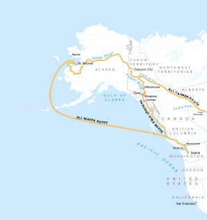
 The route from Dyea via Whitehorse to Dawson on the Klondike (middle) |
||
Dyea /ˈdaɪ.iː/ is an abandoned gold rush town in Alaska in the north of the Inside Passage at the confluence of the Taiya River in the Taiya Inlet .
history
The region around Dyea was home to the Tlingit Indians for millennia , but came into the limelight during the Klondike gold rush in the late 19th century. Dyea became the port of destination and starting point for the overland route to Dawson over the Chilkoot Pass for the prospectors alongside the neighboring Skagway .
In 1898, at the height of the gold rush, Dyea had 8,000 residents, 48 hotels , 47 restaurants , 39 saloons and 19 freight companies. However, when the White Pass and Yukon Railway , starting from Skagway, was put into operation over the White Pass on July 20, 1898 , Dyea rapidly lost its importance. Many buildings were dismantled and rebuilt elsewhere or used as firewood. In 1903 six people still lived in the city. Today Dyea, of which only remains of the cemetery from the avalanche disaster at Chilkoot Pass on April 3, 1898, is part of the Klondike Gold Rush National Historical Park .
literature
- Stan Cohen: Gold Rush Gateway Skagway and Dyea Alaska . Pictorial Histories Publishing Company, 1986, ISBN 0-933126-48-4 .

