Muskingum River
| Muskingum River | ||
|
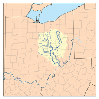
Catchment area of the Muskingum River. |
||
| Data | ||
| Water code | US : 1084024 | |
| location | State of Ohio , USA | |
| River system | Mississippi River | |
| Drain over | Ohio → Mississippi → Gulf of Mexico | |
| origin | Confluence of the Tuscarawas and Walhonding Rivers 40 ° 16 ′ 31 ″ N , 81 ° 52 ′ 23 ″ W |
|
| muzzle |
Ohio River at Marietta Coordinates: 39 ° 24 ′ 33 " N , 81 ° 27 ′ 22" W 39 ° 24 ′ 33 " N , 81 ° 27 ′ 22" W
|
|
| length | 179 km | |
| Catchment area | 20,852 km² | |
| Left tributaries | Wills Creek | |
| Right tributaries | Wakatomika Creek, Licking River, Moxahala Creek, Wolf Creek |
|
| Small towns | Conesville, Trinway, Dresden, Zanesville, Philo, Malta, Beverly, Lowell, Stockport Devola, Marietta |
|
The Muskingum River is a 179 km long tributary of the Ohio River , which in turn is a tributary of the Mississippi. It flows through the southeast of the US state Ohio . The river was an important waterway in the past.
source
The Muskingum does not spring from any source, but arises near the town of Coshocton in eastern Ohio from the confluence of its two upper courses, the Tuscarawas River and the Walhonding River . It drains large parts of the eastern Ohio.
course
The Muskingum flows from Coshocton in a generally southerly direction , forming numerous meanders . At Conesville it excludes another important tributary, the Wills Creek . Then Trinway and Dresden are passed before the river reaches Zanesville further south .
From Zanesville the course bends in a southeastern direction. In the further course the Muskingum passes or flows through the places South Zanesville , Philo , Malta , McConnelsville , Beverly , Lowell as well as Stockport and Devola . In the southeast of the state of Ohio, near the city of Marietta , the Muskingum flows into the Ohio after 178 km.
Historical meaning
The name Muskingum comes from a term used by the Delaware Indians that is said to mean "eye of the elk". The Native American name suggests a certain importance of the river for the Native Americans .
The first permanent settlement in the Northwest Territory was established on the Muskingum River in 1788 : Marietta. Here the Muskingum flows into the Ohio. In 1791, the Big Bottom Massacre took place on the nearby banks , in which Indians attacked a colonist settlement, killing 14 settlers and kidnapping three. A decade after Marietta, a few miles upstream Zanesville was founded (1799). This place was strategically located at the intersection of the Muskingum and an important, albeit hardly a path, trade route called Zane's Trace , which was regionally important during colonization and the War of Independence. In the mid-19th century, the Muskingum was an important waterway and an important trade route. For this purpose, the river was increasingly channeled and provided with dams and weirs and sluices, which could also be used to regulate the water level.
Around 1920, the importance of shipping decreased significantly as the railroad system took over a lot of transport. The locks and weirs were falling into disrepair. The facilities have been renovated since the 1960s and have since been used for the increasing traffic of recreational vehicles ( canoes , fishing boats, etc.) and excursion boats. Most of the plants are still hand-operated. At times the boaters were allowed to operate the locks themselves if necessary.
Between 1812 and 1861, many runaway slaves from the southern states fled north along the Ohio and Muskingum rivers towards Canada . This path became the path to freedom for many ex-slaves.
Name variants
For the Muskingum River, other names existed in the history or regionally:
- Big Muskingum River
- Elk River
- Mouskindom River
- Mushkingum River
- Muskingham River
- Riviere Chiagnez
Web links
- Muskingum River State Park with information about the locks.
- Muskingum River Information from The Marietta Times with information, maps and stories about the historical river.
Individual evidence
- ↑ See DeLorme (ed.): Ohio Atlas & Gazetteer . Yarmouth, Maine 1991. ( ISBN 0-89933-233-1 ).
- ↑ cf. Cayton, Andrew RL: The Contours of Power in a Frontier Town: Marietta, Ohio, 1788-1803 , in: Journal of the Early Republic, o. O. 1986, pp. 103f.
- ↑ cf. The Marietta Times (online) ( Memento of the original from October 12, 2007 in the Internet Archive ) Info: The archive link was inserted automatically and has not yet been checked. Please check the original and archive link according to the instructions and then remove this notice. .

