
Neuwied district
| coat of arms | Germany map |
|---|---|

|

Coordinates: 50 ° 34 ' N , 7 ° 28' E |
| Basic data | |
| State : | Rhineland-Palatinate |
| Administrative headquarters : | Neuwied |
| Area : | 626.9 km 2 |
| Residents: | 182,811 (Dec. 31, 2019) |
| Population density : | 292 inhabitants per km 2 |
| License plate : | NO |
| Circle key : | 07 1 38 |
| NUTS : | DEB18 |
| Circle structure: | 62 parishes |
| Address of the district administration: |
Wilhelm-Leuschner-Strasse 9 56564 Neuwied |
| Website : | |
| District Administrator : | Achim Hallerbach ( CDU ) |
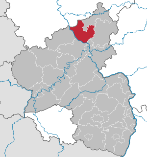
| Location of the district of Neuwied in Rhineland-Palatinate | |
  |
|
The district of Neuwied is a regional authority in the north of Rhineland-Palatinate . The seat of the district administration and at the same time the most populous city is Neuwied of the same name . The district extends roughly between Koblenz in the south and the state border with North Rhine-Westphalia in the north.
geography
location
The district of Neuwied extends north-east along the Rhine . The Rhine is the south-western border for 40 km. The district mainly has a share in the Westerwald ( Rhine-Westerwald Nature Park ). The largest river next to the Rhine is the Wied , which crosses the district from north to south.
Neighboring areas
The district borders clockwise to the north, starting with the Rhein-Sieg district (in North Rhine-Westphalia ) and the districts of Altenkirchen (Westerwald) , Westerwaldkreis , Mayen-Koblenz and Ahrweiler (all in Rhineland-Palatinate).
history
Before 1803, the area of today's Neuwied district was predominantly part of the electorates of Trier and Cologne and the county of Wied . In 1806 the entire current district area belonged to the Duchy of Nassau . After the Congress of Vienna , the area became part of the Kingdom of Prussia in 1815 . In 1816 the district of Neuwied was formed within the province of Grand Duchy of Lower Rhine (from 1822 Rhine province ) and belonged to the administrative district of Koblenz .
Under the Prussian administration, the district was divided into mayor's offices . In 1817 the Neuwied district included the mayor offices of Altenwied , Anhausen , Asbach , Dierdorf , Heddesdorf , Neuerburg , Neustadt , Neuwied , Niederwambach and Puderbach . The Linz district, also formed in 1816, was dissolved in 1822 and the mayor's offices of Leutesdorf , Linz and Unkel were incorporated into the Neuwied district. At the same time, the Engers mayor's office from the Koblenz district was assigned to the Neuwied district. The mayor's office Altenwied was dissolved in 1823 and the communities were divided between the mayor's offices of Asbach and Neustadt. The mayor's offices were renamed to offices in 1927 and existed until 1968. The association communities emerged from them .
The name Neuwied district was changed to Rhein-Wied district in 1935 and to Neuwied district in 1938 . In 1946 the Neuwied district became part of the then newly formed state of Rhineland-Palatinate, and the term Neuwied district is still often in use today. On November 7, 1970, the district received the community of Marienhausen from the Unterwesterwaldkreis and the district Heckenhahn of the community of Rott from the district of Altenkirchen (Westerwald).
Population statistics
With just under 300 inhabitants per km², the Neuwied district has the third highest population density of all districts in Rhineland-Palatinate .
| year | Residents | source |
|---|---|---|
| 1816 | 38.175 | |
| 1838 | 54,342 | |
| 1871 | 68.194 | |
| 1885 | 74,620 | |
| 1900 | 82,838 | |
| 1910 | 92,793 | |
| 1925 | 100.116 | |
| 1939 | 109,027 | |
| 1950 | 120,874 | |
| 1960 | 133,000 | |
| 1970 | 148,200 | |
| 1980 | 154,300 | |
| 1990 | 163,000 | |
| 2000 | 184,300 | |
| 2010 | 180.995 | |
| 2020 | 188,851 |
Denomination statistics
According to the 2011 census , in 2011 26.3% of the population were Protestant , 44.4% were predominantly Roman Catholic and 29.3% were non-denominational , belonged to another religious community or did not provide any information. Currently (as of April 30, 2020) of the 185,153 inhabitants (with main residence), 42,001 (22.7%) are Protestants, 71,490 (38.6%) are Roman Catholics and 38.7% belong to another religious community or are non-denominational.
politics
District council
The district council of the Neuwied district consists of 50 district council members elected in a personalized proportional representation and the district administrator as chairman. After the last district election on May 26, 2019 , the following distribution of seats results:
| year | SPD | CDU | Green | FDP | left | AfD | FWG | total |
|---|---|---|---|---|---|---|---|---|
| 2019 | 12 | 17th | 8th | 3 | 2 | 4th | 4th | 50 seats |
| 2014 | 15th | 21st | 4th | 2 | 2 | 3 | 3 | 50 seats |
| 2009 | 17th | 20th | 3 | 4th | 2 | - | 4th | 50 seats |
| 2004 | 15th | 25th | 3 | 3 | - | - | 4th | 50 seats |
| 1999 | 19th | 24 | 2 | 2 | - | - | 3 | 50 seats |
- FWG = Free Voting Group of the District of Neuwied e. V.
Due to the peculiarities of the Rhineland-Palatinate electoral system in local elections ( personalized proportional representation ), the percentage of votes shown in the graphic are shown as "weighted results", which can only represent the voting behavior arithmetically.
District Administrator
- Achim Hallerbach (CDU) has been the district administrator since 2018 , and in the last election on September 24, 2017, he received 52.84 percent of the votes cast.
- The councilors are Michael Mahlert (SPD), and honorary Werner Wittlich (CDU) and Birgit Haas (SPD).
Former district administrators were:
- 1816–1822 Carl von Gaertner
- 1822–1851 Philipp von Hilgers
- 1851–1877 Eduard Justus von Runkel
- 1877–1906 Friedrich von Runkel
- 1906–1919 Kurt von Elbe
- 1919–1933 Robert Grossmann
- 1933–1945 Rudolf Reppert
- 1945 Ludwig Schmidt-Weyland (provisional)
- 1945–1947 Kurt Goebel
- 1947–1960 Wilhelm Bruchhäuser (provisional until 1948)
- 1960–1981 Josef Oster
- 1981 Hans-Valentin Kirschner (acting)
- 1982–1983 vacant
- 1983–1993 Hans-Dieter Deckert
- 1993-2017 Rainer Kaul
Landtag and Bundestag
- The district of Neuwied is divided into the state electoral districts of Linz am Rhein / Rengsdorf (constituency 3) and Neuwied (constituency 4). The directly elected members of the Landtag in the 2016 state elections were Ellen Demuth (CDU) in constituency 3 and Fredi Winter (SPD) in constituency 4 . Jan Bollinger (AfD) also received a seat in the Rhineland-Palatinate state parliament from the Neuwied district via the state list (3rd place on the list) . Fredi Winter resigned from the state parliament on June 7, 2019, his successor is Sven Lefkowitz .
- Together with the Altenkirchen (Westerwald) district, the Neuwied district is part of the Neuwied constituency . In the general election in 2017 was Erwin Rüddel (CDU) directly elected. Sandra Weeser was able to move into the Bundestag via the FDP state list (2nd place) and Andreas Bleck via the AfD state list (3rd place).
Local partnership
The Neuwied district has had a municipal partnership with the Namysłów district in the Opole Voivodeship ( Poland ) since 2000.
Coat of arms, flag and banner

Hoist flag
banner

The Neuwied district has a coat of arms, a hoisted flag and a banner .
|
|
Blazon : “In silver a looped golden tip, inside ablue peacock striding to the right with a lowered tail; A continuous black cross at the top in front, a continuous red cross at the back. " |
|
Reasons for the coat of arms: The three coat of arms figures refer to the three territorial rulers that existed in the district until 1803 or 1806: the peacock stands for the County of Wied , the black cross for Kurköln and the red cross for Kurtrier .
The peacock is a rather rare symbol in heraldry . The coat of arms was designed in 1925 by the Neuwied painter and graphic artist Gustav Bernhard Rüschhoff and approved by the responsible Prussian State Ministry on July 14, 1927. It is one of the oldest district coats of arms in Germany. The Prussian districts - like the mayor's offices (offices since 1927) and rural communities - were not considered to be "coat of arms" until the period after the First World War. It was not until the Weimar Republic that various decrees of the Prussian Minister of the Interior 1927–1932 regulated the basics of the coat of arms of the districts. |
Economy and Transport
In the 2016 Future Atlas, the Neuwied district was ranked 230 out of 402 districts, municipal associations and independent cities in Germany, making it one of the regions with a “balanced risk-opportunity mix”. In the 2019 edition, it was ranked 261 out of 401.
traffic
The Cologne – Neuwied – Vallendar – Koblenz line of the Rheinische Eisenbahn-Gesellschaft has been running along the right bank of the Rhine since 1869 . The direct Neuwied – Koblenz line was not put into operation by the Prussian State Railways until 1918. The following year the Rhine crossing at Remagen was also completed. Up into the Westerwald, branch lines led from Engers via Siershahn – Dierdorf to Altenkirchen since 1884 and from Linz via Neustadt (Wied) to Flammersfeld since 1912. The northern tip of the district around Asbach and Buchholz received a narrow-gauge connection to Hennef in 1892 by the Brölthaler Eisenbahn AG . There were also pure freight railways in Neuwied and Bad Hönningen.
Passenger traffic was stopped on routes 59 km in length. Only the main line on the right bank of the Rhine remained with one branch (45 km). Local traffic in the district town of Neuwied and its suburbs was served by a 20 km long electric tram network from 1901, which the district operated on its own. It was converted to trolleybus traffic in 1949/1950 and later to bus routes.
The federal motorway 3 ( Cologne - Frankfurt am Main ) runs through the district . Furthermore, several federal roads, country roads and district roads run through the district area, including the B 42 (Koblenz – Bonn), the B 256 and the B 413 .
Communities
The Neuwied district comprises 62 communities. 61 of them are local churches. These belong to seven association communities , one city is free of association and therefore does not belong to any association municipality. The largest city is Neuwied with 64,765 inhabitants, the smallest municipality is Ratzert with 237 inhabitants. The following is a list of the municipalities with their local municipalities and the number of inhabitants on December 31, 2019. The administrative offices of the municipalities are marked with an asterisk (*).


The following municipalities in the district have lost their independence to this day:
|
|
Several parishes have been renamed:
- The municipality of Alberthofen was renamed Steimel on May 1, 1967 .
- The municipality of Bertenau was renamed Neustadt (Wied) in 1953 .
- The Bremscheid community was renamed Hausen (Wied) on October 1, 1971 .
For lists on the term "area changes" see area reforms in Rhineland-Palatinate .
License Plate
On July 1, 1956, the district was assigned the distinctive sign NW when the vehicle registration number that is still valid today was introduced . This identifier was changed to NR (derived from Neuwied am Rhein ) on August 1, 1956, in order to be able to transfer the old distinctive sign to the urban district of Neustadt an der Weinstrasse and the district of the same name . The NR label is still issued today.
Web links
|
Further content in the sister projects of Wikipedia:
|
||
|
|
Commons | - multimedia content |
|
|
Wiktionary | - Dictionary entries |
- Website of the district of Neuwied
- Statistical data for the district of Neuwied from the State Statistical Office of Rhineland-Palatinate
- Literature from and about Neuwied district in the catalog of the German National Library
- Literature on the district of Neuwied in the Rhineland-Palatinate state bibliography
Individual evidence
- ↑ State Statistical Office of Rhineland-Palatinate - population status 2019, districts, communities, association communities ( help on this ).
- ↑ Official municipality directory 2006 ( Memento from December 22, 2017 in the Internet Archive ) (= State Statistical Office Rhineland-Palatinate [Hrsg.]: Statistical volumes . Volume 393 ). Bad Ems March 2006, p. 164 (PDF; 2.6 MB). Info: An up-to-date directory ( 2016 ) is available, but in the section "Territorial changes - Territorial administrative reform" it does not give any population figures.
- ^ Contributions to the statistics of the Königl. Prussian Rhineland. 1829, p. 20 , accessed November 11, 2017 .
- ^ The Rhine Province under Prussia, Willemsen, 1842
- ↑ a b Community encyclopedia for the Kingdom of Prussia 1885
- ↑ a b c d e f Michael Rademacher: German administrative history from the unification of the empire in 1871 to the reunification in 1990. neuwied.html. (Online material for the dissertation, Osnabrück 2006).
- ↑ Statistical Yearbook for the Federal Republic of Germany 1972
- ↑ Statistical Yearbook for the Federal Republic of Germany 1981
- ↑ Statistical Yearbook for the Federal Republic of Germany 1992
- ↑ Statistical Yearbook for the Federal Republic of Germany 2002
- ↑ Landkreis Neuwied municipal statistics , accessed on May 9, 2020
- ↑ Landkreis Neuwied Religion , 2011 census
- ↑ Landkreis Neuwied municipal statistics , accessed on May 17, 2020
- ↑ election results. Retrieved May 30, 2019 .
- ↑ Explanation by the Land Returning Officer on the "Weighted Result"
- ^ Horst Romeyk : The leading state and municipal administrative officials of the Rhine Province 1816–1945 (= publications of the Society for Rhenish History . Volume 69 ). Droste, Düsseldorf 1994, ISBN 3-7700-7585-4 , p. 285-286 .
- ↑ a b c d e f g The district administrators of the Linz and Neuwied districts from 1816 to 2016. Heimatverein Rheinbreitbach e. V., accessed June 24, 2016 .
- ↑ SPD parliamentary group welcomes new MP Sven Lefkowitz. Press release. SPD parliamentary group Rhineland-Palatinate, June 7, 2019, accessed on June 11, 2019 .
- ↑ Future Atlas 2016. (No longer available online.) Archived from the original on October 2, 2017 ; accessed on March 23, 2018 . Info: The archive link was inserted automatically and has not yet been checked. Please check the original and archive link according to the instructions and then remove this notice.
- ↑ Future Atlas 2019 | Handelsblatt. Retrieved December 10, 2019 .
- ↑ State Statistical Office of Rhineland-Palatinate - population status 2019, districts, communities, association communities ( help on this ).
Districts:
Ahrweiler |
Altenkirchen (Westerwald) |
Alzey-Worms |
Bad Dürkheim |
Bad Kreuznach |
Bernkastel-Wittlich |
Birkenfeld |
Cochem cell |
Donnersbergkreis |
Eifelkreis Bitburg-Prüm |
Germersheim |
Kaiserslautern |
Kusel |
Mainz-Bingen |
Mayen-Koblenz |
Neuwied |
Rhine-Hunsrück District |
Rhein-Lahn district |
Rhine-Palatinate District |
Southern Wine Route |
Southwest Palatinate |
Trier-Saarburg |
Vulkaneifel |
Westerwaldkreis
Independent cities:
Frankenthal (Pfalz) |
Kaiserslautern |
Koblenz |
Landau in the Palatinate |
Ludwigshafen am Rhein |
Mainz |
Neustadt an der Weinstrasse |
Pirmasens |
Speyer |
Trier |
Worms |
Zweibrücken