Döttesfeld
| coat of arms | Germany map | |
|---|---|---|

|
Coordinates: 50 ° 38 ' N , 7 ° 33' E |
|
| Basic data | ||
| State : | Rhineland-Palatinate | |
| County : | Neuwied | |
| Association municipality : | Puderbach | |
| Height : | 226 m above sea level NHN | |
| Area : | 5.86 km 2 | |
| Residents: | 645 (Dec. 31, 2019) | |
| Population density : | 110 inhabitants per km 2 | |
| Postal code : | 56305 | |
| Area code : | 02685 | |
| License plate : | NO | |
| Community key : | 07 1 38 013 | |
| Community structure: | 4 districts | |
| Association administration address: | Hauptstrasse 13 56305 Puderbach |
|
| Website : | ||
| Local Mayor : | Martin Fischbach | |
| Location of the local community Döttesfeld in the district of Neuwied | ||
Döttesfeld is a municipality in the Neuwied district in the north of Rhineland-Palatinate . The municipality belongs to the Verbandsgemeinde Puderbach , which has its administrative seat in the municipality of Puderbach . Döttesfeld is a state-approved resort .
Geographical location
The community lies in the Westerwald in the valley of Wied in the nature reserve Rhein-Westerwald . The district is surrounded by three cardinal points from the Altenkirchen district ; Neighboring communities are Oberlahr in the west, Eichen in the northwest and Pleckhausen and Dürrholz in the south.
The community consists of the districts of Bauscheid, Breitscheid, Döttesfeld and Oberehre .
history
Today's municipality of Döttesfeld was created on June 7, 1969 through the merger of the municipalities of Döttesfeld, Bauscheid and Oberehren.
- Population development
The development of the population of Döttesfeld in relation to today's municipality area; the values from 1871 to 1987 are based on censuses:
|
|
politics
Municipal council
The council in Döttesfeld consists of twelve council members, who in the local elections on May 26, 2019 in a majority vote were elected, and the honorary mayor as chairman.
mayor
Martin Fischbach became the local mayor of Döttesfeld in 1994. In the direct election on May 26, 2019, he was confirmed in his office for another five years with 84.40% of the votes.
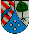
coat of arms
|
Blazon : “With a looped blue tip, in it four 1: 2: 1 set silver edge cubes, split; in front, divided obliquely by silver and red, and covered by a blue peacock turned to the left; behind in silver a green linden tree with a rooted black trunk. "
The coat of arms has been legally valid since January 26, 1971 based on a design by Ernst Zeller, Raubach. |
|
| Justification of the coat of arms: The peacock on the diagonal division is taken from the coat of arms of the Counts of Wied , whose territory Döttesfeld belonged to until 1806. Red and silver are the colors of Isenburg , which Döttesfeld originally owned. The judicial linden tree indicates the formerly Wied judicial district of Puderbach. The four cubes symbolize the four districts of Döttesfeld, Bauscheid, Oberehre and Breitscheid. |
Cultural monuments
See the list of cultural monuments in Döttesfeld
traffic
- In the immediate vicinity of the community runs the federal highway 256 , which leads from Neuwied to Altenkirchen .
- The next motorway junction is Neuwied on federal motorway 3 .
- Nearest ICE - station is Montabaur on the high-speed line Cologne-Rhine / Main .
Web links
Individual evidence
- ↑ State Statistical Office of Rhineland-Palatinate - population status 2019, districts, communities, association communities ( help on this ).
- ↑ State Statistical Office Rhineland-Palatinate (ed.): Official directory of the municipalities and parts of the municipality. Status: January 2019 [ Version 2020 is available. ] . S. 51 (PDF; 3 MB).
- ↑ Official municipality directory (= State Statistical Office of Rhineland-Palatinate [Hrsg.]: Statistical volumes . Volume 407 ). Bad Ems February 2016, p. 162 (PDF; 2.8 MB).
- ↑ State Statistical Office Rhineland-Palatinate: My village, my city. Retrieved July 3, 2019 .
- ↑ Local election Rhineland-Palatinate 2019, local council
- ↑ Local council Döttesfeld constitutes itself. NR-Kurier, August 1, 2014, accessed on March 15, 2020 .
- ^ The Regional Returning Officer for Rhineland-Palatinate: direct elections 2019. see Puderbach, Verbandsgemeinde, second line of results. Retrieved March 15, 2020 .


