
Hümmerich
| coat of arms | Germany map | |
|---|---|---|

|
Coordinates: 50 ° 34 ' N , 7 ° 30' E |
|
| Basic data | ||
| State : | Rhineland-Palatinate | |
| County : | Neuwied | |
| Association municipality : | Rengsdorf-Waldbreitbach | |
| Height : | 358 m above sea level NHN | |
| Area : | 4.27 km 2 | |
| Residents: | 759 (Dec. 31, 2019) | |
| Population density : | 178 inhabitants per km 2 | |
| Postal code : | 53547 | |
| Area code : | 02687 | |
| License plate : | NO | |
| Community key : | 07 1 38 030 | |
| Association administration address: |
Westerwaldstrasse 32–34 56579 Rengsdorf |
|
| Website : | ||
| Local Mayor : | Achim Schmidt | |
| Location of the local community Hümmerich in the district of Neuwied | ||
  |
||


Hümmerich is a municipality in the Neuwied district in the north of Rhineland-Palatinate . It belongs to the community of Rengsdorf-Waldbreitbach .
geography
The place is located in the Rhine-Westerwald nature park around 10 km north of Rengsdorf. The closest places are Krunkel in the north and Willroth in the east (both to the Altenkirchen district ). A distinction is made between the districts of Ober- (about 360 m above sea level ) and Niederhümmerich ( 320 m above sea level ). To the west, the municipality falls with the Hümmericher Bach into the valley of the Dasbach , where it is 207 m above sea level in the outer southwest . NHN reaches its lowest point of the ground . The Hümmericher Mühle and Karlshof residential areas belong to Hümmerich.
climate
The annual precipitation is 896 mm. The rainfall is high. They are in the upper quarter of the values recorded in Germany. Lower values are registered at 77% of the measuring stations of the German Weather Service . The driest month is February, the most precipitation falls in August. In August there is 1.5 times more rainfall than in February. The rainfall is distributed fairly evenly over the year. Lower seasonal fluctuations are recorded at 31% of the measuring stations .
history
The oldest evidence of human settlement in the area of Hümmerich was found in Upper Hümmerich 1935, a sharp nackiges stone ax from Flint (Flint) and comes from the younger Stone Age about 3000 to 1600 BC. Chr.
It is estimated that Hümmerich emerged from a single farm at the end of the 9th century. In a document from the Archbishop of Trier from the year 857, the "White Stone" is mentioned as a border mark. In this document the tenth district of the Rengsdorf church belonging to the St. Kastorstift in Koblenz is delimited.
For many years the border between the County of Wied and the Electorate of Trier ran near Hümmerich . Several boundary stones with the year 1788 were found.
Mining and ore were already being mined here in the Middle Ages, as can be seen today, funnel-shaped depressions, so-called pingen fields . In the second half of the 19th century, a small amount of brown iron stone was mined here again .
See also the list of cultural monuments in Hümmerich
- Statistics on population development
The development of the population of Hümmerich, the values from 1871 to 1987 are based on censuses:
|
|
politics
Municipal council
The council in Hümmerich consists of twelve council members, who in the local elections on May 26, 2019 in a majority vote were elected, and the honorary mayor as chairman.
mayor
Achim Schmidt became the local mayor of Hümmerich on July 11, 2014. In the direct election on May 26, 2019, he was confirmed in his office for another five years with a share of the vote of 86.23%. Achim Schmidt's predecessor was Edwin Roth, who held the office for 15 years.
Culture and sights
The Hümmerich "Thick Oak" ( Quercus petraea ) planted around 1700 at the entrance to the village on Landesstrasse 270 as part of the local coat of arms is registered as an official natural monument of the State of Rhineland-Palatinate (No. ND-7138-441).

Natural monument oak, entrance to town on L270
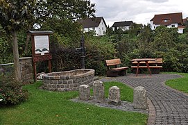
Fountain with landmarks

Old syringe house, now a scale museum


traffic
- Hümmerich is on Landesstraße 270, via this the B 256 , which leads from Neuwied to Altenkirchen , can be reached.
- The next motorway junction (36) is Neuwied on the A3 .
- Nearest ICE - station is Montabaur on the high-speed line Cologne-Rhine / Main .
tourism
After winning first place in the competition “ Our village should be more beautiful ” in 1969/1970, Hümmerich was awarded the title “State-approved climatic health resort ” in 1970 , but this was canceled in 2015 in the State Gazette for Rhineland-Palatinate.
Web links
Individual evidence
- ↑ State Statistical Office of Rhineland-Palatinate - population status 2019, districts, communities, association communities ( help on this ).
- ↑ State Statistical Office Rhineland-Palatinate (ed.): Official directory of the municipalities and parts of the municipality. Status: January 2019 [ Version 2020 is available. ] . S. 53 (PDF; 3 MB).
- ↑ State Statistical Office Rhineland-Palatinate - regional data
- ^ The Regional Returning Officer Rhineland-Palatinate: Local elections 2019, city and municipal council elections
- ^ The Regional Returning Officer Rhineland-Palatinate: direct elections 2019. see Rengsdorf-Waldbreitbach, Verbandsgemeinde, eighth line of results. Retrieved March 10, 2020 .
- ↑ Local parish Hümmerich: 1st meeting of the local parish council of the local parish Hümmerich (public). July 11, 2014, accessed March 10, 2020 .
- ↑ Natural monument received an information board. Local community Hümmerich, 2016, accessed on April 18, 2019 .
- ↑ Local community Hümmerich: Chronicle Verkehrs- und Verschönerungsverein Hümmerich e. V. Accessed April 19, 2019 .
- ^ Local community Hümmerich: Report 5th meeting of the local council OG Hümmerich (5.3.2015). (PDF) March 5, 2015, accessed April 19, 2019 .

Cities: Bad Hönningen | Dierdorf | Linz on the Rhine | Neuwied | Uncle . Municipalities: Anhausen | Asbach | Bonefeld | Breitscheid (Westerwald) | Bruchhausen | Buchholz (Westerwald) | Dattenberg | Datzeroth | Dernbach | Döttesfeld | Dry wood | Ehlscheid | Drake | Oath of May | Hammerstein (on the Rhine) | Hanroth | Hardert | Harschbach | Hausen (Wied) | Hümmerich | Isenburg (Westerwald) | Kasbach-Ohlenberg | Kleinmaischeid | Kurtscheid | Leubsdorf (on the Rhine) | Leutesdorf | Linkenbach | Marienhausen | Meinborn | Melsbach | Neustadt (Wied) | Niederbreitbach | Niederhofen | Niederwambach | Oberdreis | Oberhonnefeld-Gierend | Upper wheels | Ockenfels | Puderbach | Ratzert | Raubach | Rengsdorf | Rheinbreitbach | Rheinbrohl | Rodenbach near Puderbach | Rossbach (Wied) | Rüscheid | Saint Catherine | Stebach | Steimel | Street house | Thalhausen | Urbach (Westerwald) | Vettelschoss | Waldbreitbach | Windhagen | Woldert .