
Rheinbreitbach
| coat of arms | Germany map | |
|---|---|---|

|
Coordinates: 50 ° 37 ' N , 7 ° 14' E |
|
| Basic data | ||
| State : | Rhineland-Palatinate | |
| County : | Neuwied | |
| Association municipality : | Uncle | |
| Height : | 75 m above sea level NHN | |
| Area : | 6.58 km 2 | |
| Residents: | 4493 (Dec. 31, 2019) | |
| Population density : | 683 inhabitants per km 2 | |
| Postal code : | 53619 | |
| Area code : | 02224 | |
| License plate : | NO | |
| Community key : | 07 1 38 062 | |
| Association administration address: | Linzer Strasse 4 53572 Unkel |
|
| Website : | ||
| Local Mayor : | Roland Thelen | |
| Location of the local community Rheinbreitbach in the district of Neuwied | ||
  |
||


Rheinbreitbach is a municipality in the Neuwied district in the north of Rhineland-Palatinate (Germany). With Bad Honnef in the Rhein-Sieg district, it borders directly on the state of North Rhine-Westphalia . The municipality belongs to the Unkel association, which has its administrative seat in Unkel .
geography
The local community is located as a southern suburb of Bad Honnef on the northern Middle Rhine opposite Oberwinter and south of the Siebengebirge . In terms of natural space, the west of the municipality in the Rhine Valley can be assigned to the Honnef valley widening , a middle section to the Linz Terraces and the east to the Rheinwesterwälder volcanic ridge ( Niederwesterwald ).
The largest north-south extension of the municipality is about 2 km, the largest east-west extension about 7 km. It comprises an area rising from the west (bank of the Rhine) to the east. The district of Breite Heide lies roughly in the middle between east and west at about 190 m above sea level. NHN . The municipality to the east of the Breiten Heide is about 200-300 m wide and, with the exception of the Rottlandhof ( 310 m above sea level ) on the northeastern municipality border, uninhabited. Below the Asberg is at a good 375 m above sea level. NHN reached the highest point of the municipality, the lowest at 52 m above sea level. NHN on the banks of the Rhine. At 8.4%, a small proportion of the 6.58 km² municipal area is used for agriculture, 51.8% are forest. The residential areas Rolandsmühle , Rottlandhof and (group of houses) Ziegelei belong to Rheinbreitbach .
The residential development Rheinbreitbach extends from the federal highway 42 and the right Rhine route in the west to the slopes of the mountains (from north to south) Auf dem Hohn , Koppel , Mühlenberg and Müllershardt and into the valley of the Breitbach, which gives the municipality its name, in the east. This rises in the urban area of Unkels north of the Bruchhausen pit Sankt Marienberg , in its valley lies the brickworks group of houses, half of which also belong to the Scheuren district . To the west of the railway line and the B 42, the Rolandsmühle residential area at the mouth of the Honnefer Graben border brook south of the Bad Honnefer Lohfeld and the Mühlenweg settlement are the only permanently inhabited areas of the municipality on the Rhine. There are also two excavated ponds east and west of the railway line in the so-called maar . There is also a campsite on the Rhine in the corridor Auf dem Salmenfang, lined with tall poplars . A drinking water protection area extends north of the center of Rheinbreitbach , the core of which is Bad Honnefer Lohfeld.
Neighboring communities are Bad Honnef in the north, Windhagen in the east, Unkel in the south and Remagen in the west, to which the border runs in the middle of the Rhine.
history
Finds from Roman times
Since several Roman coins from the period 150 to 350 AD were found in the area of the later Virneberg mine (also Firneberg ; at that time still open-cast mining ), it can be assumed that mining (copper) took place in Rheinbreitbach as early as Roman times. Other mining activities of the Romans north of the Limes are evidenced by rock mining (trachite quarry) on the Drachenfels .
First historical mention

Rheinbreitbach was probably founded in Franconian times, but was first mentioned in a document in 966 as "Breitenbach". The place has been called "Rheinbreitbach" since 1604. In the Middle Ages it was protected by a moat and four fortified gates. Only one archway of the Lower Castle has survived, the foundation walls and the grounds of the castle have been extensively renovated in recent years. The work was completed in spring 2009. The Upper Castle from the 15th century still exists in its entirety. The parish church also dates from the 15th century and the Leonhard's chapel from the 17th century.
Viticulture
The Rheinbreitbacher viticulture is almost as old as the place itself. In 1143 the monastery Rolandswerth (today Nonnenwerth ) is mentioned as the owner of large vineyards in Rheinbreitbach. Also in the Westerwald lying Cistercian monastery Marie Instead , founded in 1222, was well off in Rheinbreitbach. The monastery Schwarz-Rheindorf owned further vineyards , as well as the Cologne churches of St. Aposteln , St. Severin , St. Maria ad Gradus , St. Gereon and St. Martin . In addition to the Freiherr von Breidbach , the Duke von Berg himself had vineyards here. Most of the Rheinbreitbacher winemakers were employed as halves or third halves on the estates of the nobles and the clergy; they had to pay half or a third of the harvest to the landlord. In order to protect the extensive vineyards that stretched as far as the Rhine from grape thieves, the community employed “grape guardians”.
In the church book of Rheinbreitbach 1661 there is a record of 110 vineyards in Rheinbreitbach. From the 17th century there were reports of frequent crop failures due to cold winters or storms. A particularly good harvest was achieved in 1889, and the winemakers' income was estimated at over 100,000 marks . At the end of the 19th century, the Rheinbreitbach winemakers' sales were significantly reduced due to poor harvests (frost) and the increased occurrence of vine pests and sales difficulties for red wine due to cheaper foreign competition. As a result, the Rheinbreitbach winegrowers' association was founded in 1897. The appearance of phylloxera in Rheinbreitbach in 1907 and 1908 intensified the decline of Rheinbreitbach viticulture. After the two world wars, a severe frost followed in May in 1953 and a very cold winter in 1956, in which thousands of vines froze to death. Except for one, the remaining vintners gave up their vineyards and fields and specialized in growing vegetables, fruit and potatoes. The last professional winemaker continued viticulture until 1975. In the years that followed, a few vineyards were still tended by amateur winemakers. Until the end of the 19th century, red Burgundy varieties dominated the Rheinbreitbacher viticulture, which were pressed white and were known in earlier centuries under the collective name Rheinbleichart (Bleichert) .
Weinbau in Rheinbreitbach has been on the upswing again since 2017. A winemaker recultivated part of the Hohnerberg with the historic vineyards Im Hohn and Im Vogelsang below the Rheinblickstraße above a former winery. In 2018, a transverse terracing was carried out in the sites on an area of around 1.1 hectares, which are now planted with the grape varieties White Riesling and Red Riesling as well as Cabernet Cubin and Merlot . The grape variety Souvignier Gris is in trial cultivation.
Copper mining
.jpg)
The first documented mining in Rheinbreitbach began in 1604 with a Bartholomäus Brück (Brüggen) who put the electoral mine back into operation . Various documents and finds have shown that on the Virneberg (today the district of Breite Heide) copper was extracted in underground mining and smelted on site as early as the Middle Ages . In a log, Brück mentions a 200-year-old slag dump that was discovered at the time, and in the 18th century a previously unknown main tunnel was found at a depth of approx. 40 meters. In 1629 almost 500 quintals of copper were being produced. During the Thirty Years War , important parts of the mining facilities were destroyed by the Swedes passing through.
Around 1720 the tunnels were already over 1,000 meters long. In 1724/25 the Im Siepen mine near Bruchhausen was economically separated as St. Marienberg from the Virneberg mine, so that after 1728 the smelter (a copper smelter ) in the Breitbach valley could only be used by the Virneberg. In 1744 the workforce consisted of 80 men. During this time the mine must have been renamed St. Josephsberg . At the entrance arch of the Martinskapelle in neighboring Selhof there is a keystone with the inscription S (t.) Josepsbergh and the year 1735 as well as the depiction of the miner's mark Eisen und Bohrer. In 1756, 8,000 pounds of Breitbacher copper were used to cast a church bell at the Bonn Minster Church . In 1789 the young Alexander von Humboldt visited the Rheinbreitbacher mines on one of his first study trips, in 1791 the Elector of Cologne came .

Mining came to a temporary standstill in 1794. A little later, in 1800, a new shaft was dug to a depth of 85 meters. A busy period of activity began in the first half of the 19th century. In 1840, the 51-strong miners' union extracted 8,500 tons of ore from the mine. At the same time, the smelter in the Breitbachtal was shut down. After a few good years, civil engineering was discontinued in 1867 , one of the shafts had already reached a depth of 138 m, and in 1870 another new shaft was built. The workforce increased to 164 people and in 1880 a depth of 255 m was reached (about 115 m below the Rhine level). In 1886 the “Virneberg” was finally closed. In the 1960s, part of the former mining area was opened up and the new district of Rheinbreitbach, the Breite Heide, was built.
In the Rheinbreitbach local history museum, evidence from the mining era is on display.
In an overview map of the Bonn Higher Mining Office from 1912, 38 different mine fields are shown in the vicinity of Rheinbreitbach and Bruchhausen . In addition to the St. Josephsberg mine described here, the St. Marienberg mine in Bruchhausen and the Phinchen and Clemenslust mines east of Bruchhausen in the Kasbach valley were the most important.
Cable car to Asberg

From 1887 to 1902 there was a steam powered cable car in Rheinbreitbach for the transport of basalt mined on the Asberg . The 6.3 km long route began below the Asberg plateau in the Unkeler district and ended on the bank of the Rhine at Mühlenweg, overcoming a height difference of 362 m and bridging seven valleys. The 120 wooden pillars of the cable car were on average around 10 m high and were about 50 m apart. The railway ran south of what was then Rheinbreitbacher local expansion and also crossed vineyards . There were several buildings and facilities for recycling the basalt on Mühlenweg, the place of onward shipping. The cable car, construction of which began in 1886, was closed in 1901 due to legal disputes - dismantling began the following year.
Administrative history
Rheinbreitbach is the southernmost town in the medieval Auelgau . Wonderfully country belonged to the town since the year 1265 to the electorate of Cologne . Since the 15th century it was under the administration of the Electoral Cologne Office of Linz , which was elevated to the Oberamt around 1700, and belonged to the parish and city court of Unkel. With the 1801 peace treaty of Lunéville and the result of the Reichsdeputation Hauptschluss , Rheinbreitbach was assigned to the Principality of Nassau-Usingen (from 1806 Duchy of Nassau ) as part of the Linz office . Then it was part of the Nassau Office of Linz .
After the treaties concluded at the Congress of Vienna , Rheinbreitbach came to the Kingdom of Prussia in 1815 , which introduced new administrative structures in the Rhineland in 1816. Since then, Rheinbreitbach has belonged as a municipality to the mayor's office of Unkel (renamed “Amt Unkel” in 1927) in the Linz district , after its dissolution in 1822 to the Neuwied district. In 1885, the community of Rheinbreitbach included Benden with 7, Mühlenweg am Rhein with 18, Rolandsmühle (Lohfeld) with 3 and Virneberg with 4 residents. Since the dissolution of the Unkel office on October 1, 1968, Rheinbreitbach has been part of the Unkel community as a local community.
Postal history
In 1846, a mail expedition was set up in Unkel in the district of the Bonn post office (from 1850 Oberpostdirektion Koblenz ), whose delivery area also included Rheinbreitbach. The community had its own delivery person and left the Unkel postal district in 1863 with the opening of its own "Post Expedition 2nd Class". After the road between Rheinbreitbach and Beuel running along the banks of the Rhine was expanded, daily personal mail was set up on the Linz – Bonn route in 1852. It was discontinued temporarily in 1858 and finally in 1860. In 1876 Unkel received its own 3rd class post office , to which Rheinbreitbach was also assigned, which thus lost its postal independence. It was not until 1925 that the community received its own postal agency again, which belonged to the Honnef post office within the Cologne Post Office . In 1958 the branch post office moved into new premises. In contrast to the rest of the Unkel community, Rheinbreitbach still belongs to Bad Honnef by post.
Population development
Development of the population (December 31):
|
|
|
politics
Municipal council
The municipal council in Rheinbreitbach consists of 20 council members who were elected in a personalized proportional representation in the local elections on May 26, 2019 , and the honorary local mayor as chairman.
The distribution of seats in the municipal council:
| choice | SPD | CDU | Green | FDP | UWG | total |
|---|---|---|---|---|---|---|
| 2019 | 5 | 8th | 3 | - | 4th | 20 seats |
| 2014 | 5 | 8th | 2 | 1 | 4th | 20 seats |
| 2009 | 7th | 8th | 2 | 3 | - | 20 seats |
| 2004 | 5 | 10 | 2 | 3 | - | 20 seats |
- UWG = Independent Voting Association Rheinbreitbach
mayor
Roland Thelen became the local mayor of Rheinbreitbach in June 2018. In the direct election on May 26, 2019, he was confirmed in office for five years with 58.26% of the votes.
coat of arms
|
|
Blazon : “Divided by green and red, above a silver diagonal wave bar, below a soaring, gold-armored silver dragon , the right wing covered with a red shield with three 2: 1 set, silver labels, the left with a red shield black mallet and iron . " |
| Reasons for the coat of arms: The wavy bar indicates the location in the Rhine Valley. The dragon is the coat of arms of the Lords of Breitbach . The three silver labels in red are intended to remind of the poets and writers who lived and worked here: Brothers Grimm , Freiligrath , Simrock . Mallets and iron symbolize the old copper ore mines that were operated in the Rheinbreitbach area. The coat of arms has been legally valid since May 25, 1927. |
Culture and sights

Rheinbreitbach's medieval townscape is characterized by half-timbered houses in the center, including the Waldorfhof as one of the oldest buildings, and a few stately villas. The Lower Castle , formerly the seat of the Lords of Breitbach , has only survived as a ruin, was largely restored from 2007 to 2009 and the surrounding area was converted into a leisure area (Renesseplatz) while the Upper Castle , the residence of the early 20th century Writer Rudolf Herzog , is used today as a mayor's office and for events, in particular for the Obere Burg support group .
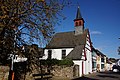
The late Gothic Catholic parish church of St. Maria Magdalena is a plastered, coral-colored building from the 15th / 16th centuries. Century with an upstream west tower and a modern extension. The interior of the church is largely from the Baroque period . The three altars are made of wood, the painting of which imitates marble. The high altar, which is described as "newly built" in a visitation report from 1620, dates in part from the 18th century.
The older Leonardus Chapel on Hauptstrasse originally dates from the 16th century and was rebuilt from 1655 after it was destroyed in the Truchsessian War . The arm reliquary of St. Leonhard of Limoges made the place a well-known pilgrimage church. The reliquary equipment includes u. a. also parts of the bones of companions of St. Ursula . The beautiful winged altar in the chapel is worth mentioning.
Also in the main street is the museum for everyday history of the Rheinbreitbacher Heimatverein, which is open on the second and fourth Sunday of the month. At the end of the village in the Breitbach valley, the so-called forest cemetery with a mourning hall has been located on a steep slope at 105–140 m since 1936 . From the paddock ( 136 m above sea level ), an elevation east of the town center, in good weather you can see Cologne Cathedral and far into the Eifel . A red oak and a copper beech north of the town center are designated as natural monuments . On the Rheinbreitbacher district in the forest east of the Breiten Heide, the wayside shrine, the Eye of God, is one of the most important sights.

Parish Church of St. Maria Magdalena
Leonard Chapel
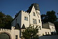
Upper castle

The eye of god


Regular events
- Carnival is traditionally celebrated in Rheinbreitbach with several meetings and a parade on Carnival Sunday.
- Rhine in Flames : on the 1st Saturday in May. Large fireworks and boat tour from Linz along the Rhine along Erpel , Unkel, Remagen, Rheinbreitbach, Rhine island Nonnenwerth near Bad Honnef, Bad Godesberg , Königswinter to Bonn's Rheinaue near Bonn .
- Museum festival on the grounds of the Heimatmuseum in Hauptstraße in even years in June. Event of the Heimatverein Rheinbreitbach.
- Fair Maria Magdalena in July
- Park festival: the last weekend in August. Joint event of the Rheinbreitbach clubs in the park of the Upper Castle.
- Wine exchange in September on Renesseplatz
- District fire brigade festival in Rheinbreitbach
Economy and Infrastructure

Rheinbreitbach is a community characterized by industrial and commercial enterprises. The number of out-commuters only slightly exceeds that of in-commuters. The more important local companies include Bluhm Systeme , a manufacturer of marking technology , MEPA - Pauli und Menden GmbH , which is active in the field of sanitary technology , and formerly the automotive supplier Recticel (location was closed at the end of 2015). In the 1990s, funds from the agreement on compensatory measures for the Bonn region were used to support the development of an industrial area east of Bundesstraße 42, in which, among other things, the “ Rheinbreitbach Technology Center for Surface Technology ” is located. This is also where the Institute for Thin Film Technology at the University of Kaiserslautern is based. At the end of the 2000s, a new retail center was built on the northern municipal boundary in the immediate vicinity of the Bad Honnef-Süd industrial park, to which the local post office has also moved.
The local community is supplied with drinking water by Bad Honnef AG in the Lohfeld waterworks .
traffic
Trunk roads
Rheinbreitbach has a junction with federal highway 42 , which has been designed as a bridge since 1992 , which connects with all neighboring cities on the Rhine (including Linz am Rhein, Unkel, Bad Honnef, Königswinter and Bonn) as well as the adjoining airport highway, Bundesautobahn 59, with Cologne Airport / Bonn connects. In May 2012 a new connection road was opened between the junction of the B 42 and Bad Honnef-Süd.
railroad
The right-hand section of the Rhine runs through the Rheinbreitbacher municipality with two barred level crossings , including a call barrier until 2014 . Depending on the location, the closest train stations are in the neighboring towns of Bad Honnef and Unkel , which can be used to take Regional Express 8 and Regionalbahn 27 in the direction of Cologne and Koblenz . Both train stations can be reached quickly via the 565 bus.
Transportation
The bus line 565 runs from Linz train station to the Bad Honnef Stadtbahn terminus of the Siebengebirgsbahn (line 66) and connects Rheinbreitbach with the Bonn light rail network . The buses run daily, every hour on weekends and up to twice an hour on weekdays during rush hour. In addition, line 133 runs from Unkel-Scheuren via Rheinbreitbach to Rheinbreitbach-Breite Heide.
Organizations
The Federation of Energy Consumers , founded in 1987, was based in Rheinbreitbach . In 2007, the association moved its federal office and thus its headquarters to the neighboring municipality of Unkel. The basketball club Rhöndorfer TV 1912 was also temporarily based in Rheinbreitbach.
Personalities
- Will Glahé (1902–1989), German accordionist, composer and band leader, died in Rheinbreitbach
- Hermann Gründel (1931–2013), German diplomat, lived and died in Rheinbreitbach
Web links
- Official website of the Rheinbreitbach community
- Historical information about Rheinbreitbach at regionalgeschichte.net
- Rheinbreitbach local history museum and archive
- Routing of the Asberg cable car (Map 1: 100,000 from 1909) ( Deutsche Fotothek )
- Historical information on viticulture in Rheinbreitbach
Individual evidence
- ↑ State Statistical Office of Rhineland-Palatinate - population status 2019, districts, communities, association communities ( help on this ).
- ↑ a b State Statistical Office Rhineland-Palatinate: Regional data.
- ↑ State Statistical Office Rhineland-Palatinate (ed.): Official directory of the municipalities and parts of the municipality. Status: January 2019 [ Version 2020 is available. ] . S. 52 (PDF; 3 MB).
- ^ The decline of viticulture in Rheinbreitbach until 1975. Retrieved on April 25, 2018 .
- ↑ Viticulture History . Retrieved April 25, 2018 .
- ↑ New viticulture on the Hohn. Retrieved April 25, 2018 .
- ↑ Cable car - Basalt vom Asberg
- ^ Dorothea F. Voigtländer: 1000 years Rheinbreitbach - community between tradition and progress. In: Heimat-Jahrbuch des Landkreis Neuwied 1977 , p. 44
- ↑ R. Knipping: The Regest of the Archbishops of Cologne in the Middle Ages , Vol. 3, No. 2.318, p. 23
- ^ Hellmuth Gensicke : Landesgeschichte des Westerwaldes . 2. Reprint. Historical Commission for Nassau, Wiesbaden 1987, ISBN 3-922244-80-7 , p. 477/478.
- ^ Community encyclopedia for the Kingdom of Prussia. Volume XII Province of Rhineland . Publishing house of the Royal Statistical Bureau, 1888, p. 44. ( online PDF ; 1.4 MB)
- ^ Albert Weidenbach: The transport system in the Honnef area in the last 100 years . In: Bad Honnef am Rhein. Contributions to the history of our home community on the occasion of their city elevation 100 years ago. Verlag der Honnefer Volkszeitung, Bad Honnef 1962, p. 144.
- ^ Theo Winterscheid: 125 years of Post in Unkel. In: Landkreis Neuwied (Ed.): Heimat-Jahrbuch des Landkreis Neuwied , Neuwied 1972, pp. 46–50.
- ^ The Regional Returning Officer Rhineland-Palatinate: Local elections 2019, city and municipal council elections
- ↑ Horst-Dieter Küsters: Roland Thelen plans to run again in 2019. May 29, 2019, accessed on February 20, 2020 .
- ^ The Regional Returning Officer for Rhineland-Palatinate: direct elections 2019. see Unkel, Verbandsgemeinde, third line of results. Retrieved February 20, 2020 .
- ↑ Landscape information system of the Nature Conservation Administration ( Memento of the original from January 4, 2016 in the Internet Archive ) Info: The archive link has been inserted automatically and has not yet been checked. Please check the original and archive link according to the instructions and then remove this notice.
- ^ Recticel closes location in Rheinbreitbach , General-Anzeiger , October 9, 2014
- ↑ KunststoffWeb.de: Recticel: New order from BMW for interior trim. KunststoffWeb GmbH, Bad Homburg, July 4, 2016, accessed on May 19, 2020 .
- ^ Rhein-Sieg-Kreis (Ed.): Yearbook of the Rhein-Sieg-Kreis. Edition 28, year 2013, Edition Blattwelt, Reinhard Zado, Niederhofen 2012, ISBN 978-3-936256-52-9 , p. 195.
- ↑ They still exist - The Call Barriers , General-Anzeiger , August 21, 2013

Cities: Bad Hönningen | Dierdorf | Linz on the Rhine | Neuwied | Uncle . Municipalities: Anhausen | Asbach | Bonefeld | Breitscheid (Westerwald) | Bruchhausen | Buchholz (Westerwald) | Dattenberg | Datzeroth | Dernbach | Döttesfeld | Dry wood | Ehlscheid | Drake | Oath of May | Hammerstein (on the Rhine) | Hanroth | Hardert | Harschbach | Hausen (Wied) | Hümmerich | Isenburg (Westerwald) | Kasbach-Ohlenberg | Kleinmaischeid | Kurtscheid | Leubsdorf (on the Rhine) | Leutesdorf | Linkenbach | Marienhausen | Meinborn | Melsbach | Neustadt (Wied) | Niederbreitbach | Niederhofen | Niederwambach | Oberdreis | Oberhonnefeld-Gierend | Upper wheels | Ockenfels | Puderbach | Ratzert | Raubach | Rengsdorf | Rheinbreitbach | Rheinbrohl | Rodenbach near Puderbach | Rossbach (Wied) | Rüscheid | Saint Catherine | Stebach | Steimel | Street house | Thalhausen | Urbach (Westerwald) | Vettelschoss | Waldbreitbach | Windhagen | Woldert .