Siebengebirge
| Siebengebirge | |
|---|---|
|
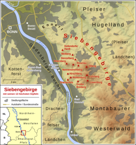
Map of the Siebengebirge with the 13 highest peaks |
|
|
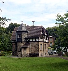
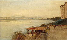
Siebengebirge 1900 |
|
| Highest peak | Great Mount of Olives ( 460.7 m above sea level ) |
| location | Rhein-Sieg-Kreis , North Rhine-Westphalia |
| part of | Lower Middle Rhine Region , Rhenish Slate Mountains |
| Classification according to | Handbook of the natural spatial structure of Germany |
| Coordinates | 50 ° 40 ′ N , 7 ° 15 ′ E |
| Type | Low mountain range |
| rock | Trachyte , latite , basalt |
The Seven Mountains is a right bank of the Rhine , southeast of Bonn , in the eastern area of the cities Königswinter and Bad Honnef located mountain range consisting of more than 50 mountains and hills. It is of volcanic origin and formed about 25.5 million years ago in the Oligocene . The last volcanic activity occurred in the Miocene and led to the formation of the Petersberg . The Siebengebirge is part of the Siebengebirge Nature Park , one of the oldest nature parks in Germany. The protection is regulated in a specific set of rules. The Siebengebirge nature reserve with even stricter protection regulations is somewhat narrower, but contains the entire Siebengebirge in addition to the western part of the Ennert to the north and the northern half of the Rheinwesterwälder volcanic ridge to the south . It is the largest contiguous nature reserve in North Rhine-Westphalia . The Siebengebirge was added to the list of 77 national geotopes awarded in 2006.
The Siebengebirge borders directly on the (natural) Westerwald to the south-east , but is already counted as part of the Middle Rhine Region ( Lower Middle Rhine Region ).
The mountains of the Siebengebirge
The following surveys are of importance (height and position in brackets, the "seven big mountains of the Siebengebirge" are printed in bold):
-
Great Mount of Olives ( 460.7 m , east) with summit restaurant
- Little Mount of Olives ( 331.7 m ; northern sub-peak of the Great Mount of Olives, northeastern rim mountain)
- Löwenburg ( 455 m , east) with castle ruins
- Lohrberg ( 432.8 m , east)
- Nonnenstromberg ( 335.9 m , west)
- Petersberg ( 335.9 m , west), name in the earlier Middle Ages Stromberg , with a Celtic ring wall, Peterskapelle, guest house of the Federal Republic of Germany
- Wolkenburg ( 324 m , west)
- Rosenau , also Grosse Rosenau ( 322.1 m , east); with castle ruins
- Drachenfels ( 320.7 m , western Siebengebirge) with castle ruins and summit restaurant
- Großer Breiberg ( 312.9 m , west)
- Stenzelberg ( 287 m , eastern edge mountain); former climbing mountain
- Hirschberg ( 256.8 m , western edge mountain)
- Dollendorfer Hardt ( 246.7 m , northernmost mountain of the (western) Siebengebirge)
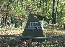
- Weilberg ( 242.1 m , eastern edge mountain); First award of the European Diploma for the Siebengebirge on October 15, 1971
Origin of the name "Siebengebirge"

The origin of the name “Siebengebirge” has not been clearly clarified. There are several explanations:
- The oldest attribution (Moller, 1590) is Seven Mountains (septem montes). Depending on the direction you are looking up or down the Rhine, you can actually see around seven mountains, although they are not always the same and also not the highest. These seven mountains can be clearly made out from Cologne Cathedral and the Kölntriangle . This explanation is the most commonly cited, albeit in the not entirely correct form, that the term "Siebengebirge" refers exactly to the seven main peaks. Rather, the number seven is often symbolic of totality, e.g. B. " Siebensachen " or " Siebenbürgen ".
- In addition, the number seven, which is also regarded as magical, seems obvious for a mountain range that until the beginning of the 19th century was considered repellent, difficult to penetrate, eerie and the setting for legends and haunted stories. For example, according to legend, the Rhine dammed up at this point because there was a chain of hills there. Behind this chain was a city that suffered from lack of water. So the citizens decided to commission seven giants to liberate the Rhine. When the work was done, the giants cleaned their spades and the mountains were formed. Another version, upstream of the Rhine, reads: Seven giants were called from Holland to dig the Binger Loch so that the Rhine could drain away. After their work they stopped on the way home to Holland near Königswinter and poked their spades into the ground. As they moved on, the chunks of earth from the spades remained as seven mountains.
- Seven could have arisen through folk etymology from the Ripuarian word Siefen , which denotes a damp brook valley, or from boiling , because of the soap makers who were active in the valleys; Since soap-boiling is associated with odor nuisance, this profession has been relocated from the surrounding villages to the remote valleys. However, there is no evidence for these folk etymological explanations: Even the oldest historically proven name is, as mentioned above, after the number seven.
The name "Siebenhaargebirge" has less local distribution. For the meaning of “hair” as a (wooded) mountain range see Hardt (toponym) and cf. Haard , tress , Hardthöhe , Rothaar etc.
Formation of the Siebengebirge
Around 400 to 350 million years ago, in the time of the Lower Devonian Sea, the bedrock of greywacke , slate and sandstone was deposited by the Devon Sea and the rivers that flow into it . About 350 to 280 million years ago this rock was pressed open and folded up. The Variscan Mountains formed , the area of which stretched from Brittany to Poland . About 67 to 58 million years ago the Variscan Mountains were affected by environmental influences, e.g. B. Wind and water removed to form a rump with a wavy surface.
About 37 million years ago, as a result of this subsidence, the North Sea shifted to the area of present-day Bonn and withdrew again to the north about 25 million years ago. From approx. 28 million years before today there was volcanic activity in the Siebengebirge region , whereby large amounts of trachytic ash were expelled and led to an originally several hundred meters thick tuff deposit . Trachytes , latites and alkali basalts penetrated the tuff cover in the form of spring dome , chimney fillings and passages . The strongest activity ended about 22 million years ago, only the extraction of basaltic rocks lasted longer, it stopped at most 15 million years ago (Walter, 1995).
The layers (especially ash) that were not resistant were again removed by the effects of wind and water. About 450,000 years ago the Rhine began to cut through the rising Rhenish Slate Mountains . The numerous curves and kinks in the course between Bingen and Bonn were created as free meanders (river loop) in a flat valley and were cut as a forced meander during the uplift. The Siebengebirge is characterized as the "core of the Middle Rhine volcanic area", which is 35 km in length in the northwest-southeast direction and 30 km in the southwest-northeast direction. It differs from the rest of this volcanic area in that it has a greater number and density of volcanic rock types .
The Siebengebirge volcanic region was formed within millions of years.
Previous use of the Siebengebirge
Quarries
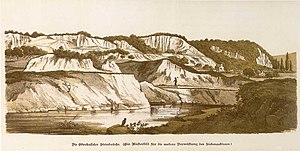
The first Roman quarries were built in the Siebengebirge as early as the 1st century AD . The Romans opened three quarries on the Drachenfels, the Rüdenet and the Großvaterstuhl. There was Trachyt mined that with vessels on the Rhine was taken away. Presumably the hard rock was used for the construction of representative buildings.
After the fall of the Roman Empire, numerous stone quarries were not reopened until the 11th century. The stones that were now extracted were used to build numerous churches in the Rhenish region . The construction of the Cologne Cathedral began in 1248 with stones from the Siebengebirge, the dismantling lasted 312 years until 1560.
Further quarries were operated by the Cistercian Abbey of Heisterbach (today's Heisterbach Monastery ) and used to erect the monastery building and the abbey church with latite stone.
In 1827 the Königswinterer Steinhauergewerkschaft acquired the mountain cone of the Drachenfels and opened several quarries in the upper mountainside. A section of the wall that fell from the castle ruins into the valley led to the quarrying being stopped by the royal government on May 4, 1828 in Cologne . In the following years, the Prussian treasury acquired the mountain cone of the Drachenfels for 10,000 Taler and was thus able to preserve the Drachenfels castle ruins . The mining in numerous other quarries in the Siebengebirge (Stenzelberg, Wolkenburg, Ennert , Dollendorfer Hardt, Rabenlay ) was not affected by this rescue measure.
Mining
The veins of the non-ferrous metals copper , lead and zinc formed in the Devonian period have been mined since Roman times at the latest. Since the 16th century, tuff stone has been extracted from the tunnel for furnace construction in Königswinter. The approximately 48,000 m² tunnel system of the Ofenkaulen was created through dismantling by 1960 .
In 1857 the discovery of a Roman silver coin was recorded in the Bonn yearbooks of the Rheinisches Landesmuseum , which was "found at a depth of 18 feet" on the Virneberg . In 1905 a Roman vessel with bronze objects was discovered in an old tunnel .
At Rheinbreitbach was the most important St. Josefs gangway, in which copper ore was mainly mined. In Schmelztal and Einsiedlertal lead and zinc ore were carved. There were numerous mines in the Aegidienberg districts of Neichen and Brüngsberg and in the nearby Quirrenbach . The northernmost deposits of the mining area were near Bennerscheid .
With the decline in the prices of non-ferrous metals, mining in the Siebengebirge came to a standstill from 1875 onwards.
Protection of the Siebengebirge
history
The numerous quarries between the 1st century AD and the 19th century led to the gradual destruction of the landscape. The quarries threatened to completely devastate the Siebengebirge. In order to save the most striking mountain and its castle ruins from the quarry operation and thus from final change, the Prussian king expropriated the owners of the Drachenfels without having any legal authorization. In 1836 the Prussian government acquired the Drachenfels including the castle ruins to protect nature for 10,000 thalers. To protect the Siebengebirge, the VVS (Beautification Association for the Siebengebirge) was founded in 1869, to which numerous wealthy citizens from Bonn belonged. After the concept of nature conservation was anchored in law for the first time in 1920 , the Siebengebirge was declared a nature reserve on June 7, 1922 by the Prussian Minister for Science, Art and Education as well as Agriculture and Forests (together with the Lüneburg Heath ). It is therefore one of the oldest nature reserves in Germany. A year later, clear cutting of forests was banned by a regulation and numerous plants and animal species were placed under protection. By another decree in 1930 each on was recovering from natural resources -related activities prohibited. All quarrying activities came to an end.
It is no coincidence that nature conservationist and patron Alfred Toepfer initiated the establishment of nature parks in Germany in a speech on June 6, 1956 in Bonn. Nature parks were set up in Germany as early as 1956, and the Siebengebirge was one of the first parks.
In 1971, the Council of Ministers of the European Council awarded the Siebengebirge Nature Park with the European Diploma (today: European Diploma for Protected Areas) for the first time. The Siebengebirge is also one of the largest Natura 2000 areas in North Rhine-Westphalia, which the member states of the EU committed to protecting with the adoption of the Fauna-Flora-Habitat Directive in 1992.
National park project
Between 2007 and 2009 the establishment of the 15th German and second North Rhine-Westphalian National Park , the Siebengebirge Citizens National Park , was discussed and operated by the state, Bonn and the Rhein-Sieg district. The plan was to upgrade the state's share of the 4800 hectare nature reserve in the Siebengebirge Nature Park to a national park. A national park center was to be built in Rhöndorf for five million euros from state funds . In Bad Honnef the national park was rejected by large parts of the population; With the first referendum in the city's history at the same time as the federal election in 2009 , the municipality was finally forbidden in September 2009 to lease the urban parts of the nature park to the country; so the national park failed.
Beautification Association for the Siebengebirge (VVS)
The Beautification Association for the Siebengebirge (VVS) was responsible for the nature park from 1986 to 2018. The association was founded on December 4, 1869 in Bonn. The first president of the VVS was Ernst Heinrich von Dechen . The main goal is to protect the Siebengebirge. The forest on the Drachenfels and the Löwenburg as well as some leased properties are owned by the VVS. Forestry, the maintenance and construction of paths are some of the subtasks. The association currently has around 1,500 members. Today the association has its headquarters in the "Nature Park House" on Margarethenhöhe , where an information center for the Siebengebirge is also located.
Today's Siebengebirge

The Siebengebirge is a wooded hilly landscape. The Siebengebirge Nature Park comprises an area of 4800 hectares and approx. 200 km of signposted hiking trails. The owners of the Siebengebirge are the cities of Bad Honnef and Bonn , the Siebengebirge embellishment association, the Federal Republic of Germany , the former Mannesmann AG (succession not finally clarified) and numerous smaller forest owners. The Siebengebirge Nature Park serves today as a recreation area and, apart from parts of the nature reserve, is used for agriculture and forestry (regulated deforestation, cultivation of wine, grain, etc.).
The Siebengebirge achieved political importance through the grand hotel and later federal guest house on the Petersberg .
traffic
Since the city of Königswinter has been designing massive building land in the Siebengebirge for years , the main roads L 331 ( Königswinter - Ittenbach ), L 268 ( Oberdollendorf - Oberpleis ) and L 490 ( Oberkassel - Birlinghoven ), which connect these areas to the main workplaces in Bonn, overloaded in rush hour traffic. That is why the city of Königswinter and a citizens' initiative are calling for the Ennert ascent (also relieving the Siebengebirge ) as part of the southern bypass, which would connect the A 562 to the A 3 with a road through the Ennert (northern foothills of the Siebengebirge) that is largely above ground and in part as a tunnel . Other citizens' initiatives, the city of Bonn and numerous places in the city of Königswinter reject this new road connection.
Since the project's chances of realization have decreased due to the removal from the federal transport route plan, a transport concept for the Siebengebirge region was drawn up and alternative relief options examined. Measures such as a bypass of Ittenbach and a tunnel through the Great Mount of Olives are now being proposed. An improvement in local public transport , on the other hand, is rejected by the traffic planners of the Rhein-Sieg district, who continue to campaign for the southern bypass.
Hiking trails
The Rheinsteig from Bonn to Wiesbaden leads over the most beautiful parts of the Siebengebirge. In Königswinter- Oberdollendorf , part of the 2.2 km long wine hiking trail there is integrated into the Rheinsteig.
Remarkable hiking trails can also be found in the countless valleys on the western slope of the Siebengebirge. Examples are the Nachtigallental (starting from Königswinter) and the Annatal / Tretschbachtal (starting from Rhöndorf).
Attractions
In addition to hiking and cycling trails through the volcanic mountain region, the Siebengebirge has numerous other attractions :
- Choir ruins of the Heisterbach Monastery
- Castle "Drachenburg
- Arboretum Park Härle at the foot of the Siebengebirge in Bonn-Oberkassel
- Drachenfels and Drachenfelsbahn
- Siebengebirgsmuseum
- Sea Life Koenigswinter
- The Brückenhof Museum in Königswinter - Oberdollendorf
- The wine hiking path in Königswinter - Oberdollendorf
- The Konrad-Adenauer-Haus in Rhöndorf
The park of Schloss Drachenburg and the Arboretum Park Härle were added to the street of garden art between the Rhine and Maas .
Legends and sagas about the Siebengebirge
There are many legends about the Siebengebirge; the medieval saga about the evil dragon is one of the most famous.
It is about a dragon who waited from his mountain - the Drachenfels - for merchant ships that sailed along the Rhine. As soon as a ship was close enough, he spat fire in that direction and watched happily as the crew burned to death or drowned in the waves of the Rhine.
One day a ship came along the Drachenfels again. However, it was loaded to the brim with powder, but the dragon did not notice it. He waited in a safe hiding place on the slope of the mountain and again spat fire in that direction when the ship was close enough. But he could just see how the ship caught fire - because in the next moment the ship exploded with a bang that could be heard as far as Cologne. The explosion carried the kite far away and it was never seen again.
Philatelic
On January 2, 2020, the first day of issue, Deutsche Post AG issued a postage stamp with a face value of 60 euro cents, which in the series shows Germany's most beautiful panoramas of the Siebengebirge. The design comes from the graphic designers Stefan Klein and Olaf Neumann from Iserlohn.
Songs
The well-known Cologne songwriter Willi Ostermann paid tribute to the Siebengebirge and the Nachtigallental valley starting from Königswinter with the song
- "Where the seven mountains stand on the Rhine beach,
you can see the blond girls with blue eyes.
And then you think a thousand times of the beautiful hours
when they happily marched through the nightingale valley. "
See also

- Oven roast
- Drachenfelsbahn and Petersbergbahn
- Heisterbacher Talbahn (1889–1950)
- Bröltalbahn
- Siebengebirgsbahn
- List of volcanoes in Germany
literature
- State Surveying Office North Rhine-Westphalia Hiking map Bonn and the Siebengebirge. ISBN 3-89439-662-8 .
- Frieder Berres, Christian Kiess: Siebengebirge - Nature Park - Places - Sights. Rheinlandia Verlag, Siegburg 1994, ISBN 3-935005-79-2 .
- Bruno P. Kremer: The Siebengebirge - nature, landscape, culture. Wienand Verlag, Cologne 2002, ISBN 3-87909-770-4 .
- Wolfgang Wegener: From the happy Elise to God's help. In: Archäologie im Rheinland 1992, Rheinland Verlag Köln 1993, ISBN 3-7927-1384-5 , p. 159ff.
- Guido Berg: Siebengebirge. KOBO Verlag, Remagen 2000, ISBN 3-930884-18-6 .
- Winfried Leischner: Siebengebirge. The huge geotope on the Rhine. A geological documentation of its formation and reshaping as well as its natural components and deposits. Rheinlandia Verlag, Siegburg 2006, ISBN 3-938535-16-4 .
- Ansgar S. Klein: Rise and Rule of National Socialism in the Siebengebirge. Essen 2008. ISBN 978-3-89861-915-8 .
Individual evidence
- ^ Arnold Gawlik, Karl-Heinz Ribbert: Oldest nature reserve in Central Europe . In: Ernst-Rüdiger Look, Ludger Feldmann (Ed.): Fascination Geology. The important geotopes of Germany , E. Schweizerbart'sche Verlagsbuchhandlung, Stuttgart 2006, ISBN 3-510-65219-3 , p. 46 f.
- ↑ Hiking map of the Siebengebirge Nature Park , State Surveying Office North Rhine-Westphalia, 7th edition 1995
- ^ Geological State Office North Rhine-Westphalia (ed.); Gangolf Knapp, Klaus Vieten: Geological map of North Rhine-Westphalia 1: 25,000. Explanations for sheet 5309 Königswinter . 3rd, revised edition, Krefeld 1995, p. 20.
- ↑ Natura 2000 area “Siebengebirge” in the specialist information system of the State Office for Nature, Environment and Consumer Protection in North Rhine-Westphalia , accessed on June 1, 2016.
- ↑ 5309-301 Siebengebirge. (FFH area) Profiles of the Natura 2000 areas. Published by the Federal Agency for Nature Conservation . Retrieved November 22, 2016.
- ^ Annette Claus, Claudia Sülzen: Answers to 15 central questions about the national park . General-Anzeiger from September 23, 2009 (accessed September 11, 2017).
- ↑ Claudia Sülzen, Rüdiger Franz: Honnefer prevent the national park . General-Anzeiger of September 28, 2009 (accessed September 5, 2017).
- ↑ Siebengebirge Nature Park - VVS . Website of the Beautification Association for the Siebengebirge. Retrieved October 30, 2012.
Web links
- "Siebengebirge" nature reserve in the specialist information system of the State Office for Nature, Environment and Consumer Protection in North Rhine-Westphalia
- World Database on Protected Areas - Siebengebirge (English)
- Pictures and historical postcards from the Siebengebirge with Drachenfels and Petersberg - focus on the Rhine
- Christoph Schwarz, The history of geological exploration of the Siebengebirge (pdf)
