
Rheinsteig
| Rheinsteig | |
|---|---|
 View from the Rheinsteig over the Rhine |
|
| Data | |
| length | approx. 320 km |
| location | on the right bank of the Rhine, on the Middle Rhine |
| Markers | Stylized R on a blue background  |
| Starting point |
Bonn 50 ° 44 ′ 8 ″ N , 7 ° 6 ′ 8 ″ E |
| Target point |
Wiesbaden 50 ° 2 ′ 17 ″ N , 8 ° 13 ′ 59.3 ″ E |
| Type | Long-distance hiking trail |
| Height difference | 11700 m |
| The highest point | 365 m |
| Lowest point | 60 m |
| Level of difficulty | light |
| season | All year round |
| particularities | Premium hiking trail . A Rheinhöhenweg runs parallel on both sides of the Rhine . |
The Rheinsteig is a long-distance hiking trail that follows the Middle Rhine and the northernmost part of the Upper Rhine on the right bank of the Rhine over a length of around 320 kilometers . It was officially opened on September 8, 2005 after the Rheinburgenweg was completed in August 2004 . On the Koblenz – Rüdesheim route, the Rheinsteig crosses the Upper Middle Rhine Valley UNESCO World Heritage Site and the Rheingau wine-growing landscape .
The parallel Rheinhöhenweg leaves the slopes of the Rhine Valley again and again and leads over the adjacent mountain tops. In places, however, it also runs closer to the Rhine than the Rheinsteig, so that often the choice remains between the paths in the river valley and the mountainous region.
The establishment of the hiking trail was a joint project of the federal states of North Rhine-Westphalia , Rhineland-Palatinate and Hesse to promote tourism in the regions along the Rhine. The German Hiking Institute in Marburg has awarded the Rheinsteig the "German Hiking Seal Premium Trail ".
The Rheinsteig was a founding member of the Top Trails of Germany association in 2009.
course
The Rheinsteig begins in Bonn (at the market square), changes to the right bank of the Rhine and leads over the Siebengebirge , around the Neuwied basin , through Koblenz- Ehrenbreitstein, crosses the Lahn at Lahnstein and then follows the Upper Middle Rhine Valley to Rüdesheim . Starting at Lorchhausen, it goes along the upper edge of the Rheingau vineyards and then back down to the wine villages. From the Niederwald monument near Rüdesheim, it stays on the edge of the Taunus and from the Eberbach Monastery makes a loop through the Taunus via Schlangenbad and then goes down to Wiesbaden , where it ends at Biebrich Castle . It accompanies the Rhine preferably on the heights, mostly near the edge of the valley, and crosses many side valleys. It leads past a number of castles and palaces. In addition to numerous viewpoints, it also has a high proportion of rocky or earthy paths and sporty challenging passages. It also connects to the existing network of hiking trails in the regions crossed and is intended to bring additional tourists to them.
A blue rectangle with a white "R" stylized as a river serves as a path marker. The blue lettering "Rheinsteig" can be read underneath. A total of around 8,000 of these signs and around 900 signposts with distance information were attached, the existence of which is suffering from souvenir hunters and vandalism. In order to get to the Rheinsteig, yellow ocher signs are placed at the next train stations, at the landing stages of the Rhine shipping and in the center of the communities. These mark the access routes to the main route. The markings are also often painted in simplified form on stones or similar fixed points.
Above Lahneck Castle, the Rheinsteig crosses the Lahnhöhenweg on the left side of the Lahn and on the right at the Ruppertsklamm the Lahnwanderweg, created in 2010 . In Bad Hönningen there is a connection to the Westerwaldsteig, which opened in May 2008 . In the Rheingau , the parallel paths Hessenweg 7 and Rheingau-Riesling-Path also lead from Kaub to Wiesbaden. The former Rheinburgenweg on the right bank of the Rhine, which is almost identical from Bendorf-Sayn to Rüdesheim am Rhein , was reduced in 2010 to the part on the left bank of the Rhine. Some old way markings can still be found.
Attractions
Special sights are: Beethoven city Bonn , Drachenfels (Siebengebirge) , ruins Löwenburg (Siebengebirge) , Erpeler Ley , historical town hall Linz , Castle Arenfels , world cultural heritage Upper Germanic-Raetian Limes , Castle Hammerstein , Castle Monrepos (Neuwied) , Römergraben Rengsdorf , Zoo Neuwied , Castle Sayn , Marienburg Vallendar , Ehrenbreitstein , Ruppertsklamm , Mark Burg , Castle Liebeneck , Filsener Ley, Steal Little , Pulsbachklamm, Burg Maus , Loreley , Pfalzgrafenstein Castle , Nollig Castle , Assmannshausen / Höllenberg, Niederwald monument , monastery Marienthal , Schloss Johannisberg , Schloss Vollrads , monastery Eberbach , the marriage vineyard near Scharfenstein Castle (Kiedrich) , Schlangenbad spa park , Grauer Stein natural monument , Goethestein , Biebrich Castle in Wiesbaden-Biebrich .
Rheinsteig guides
Rheinsteig guides operate on the Rheinsteig on behalf of cities and municipalities. Distinguishing marks are blue T-shirts and beige peaked caps .
The Rheinsteig-Lotsen project started in 2006 in the Loreley community. The municipality of Lorch am Rhein started this in 2007. The project is to be extended to Walluf by 2008.

The task of the pilots is to inform and support hikers. They also have the task of repairing minor damage, reporting major damage to the responsible authorities, and maintaining and maintaining the paths. They have a plaster on hand for minor injuries.
Rheinsteig circular tours
5 "Rheinsteig circular tours" have been set up in the immediate vicinity of the Rheinsteig:
- Fürstenweg, length 10.8 km
- Traumpfad Saynsteig, length 15.3 km
- Traumpfad Waldschluchtenweg, length 11.1 km
- Loreley extra tour, length 14.8 km
- Rauenthaler Spange, length 8.4 km
gallery

Blue markings lead along the Rheinsteig

Access: Ocher-yellow markings show the way to the main path

View of the Erpeler Ley

In Lahnstein - In the Ruppertsklamm

Lahnstein - View of Stolzenfels Castle
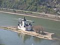
Kaub - View of Pfalzgrafenstein Castle

Between Kaub and St. Goarshausen - view from Roßstein to Oberwesel

St. Goarshausen - Wellmich and Maus Castle


Literature and maps
- Renate and Olaf Goebel: Rheinsteig WanderTOUREN / A beautiful day. 20 daily stages between Bonn and Wiesbaden, 40 short tours, altitude profiles, route maps and GPS data with download. Update 2010 with new access routes Neuwied, ideemedia, 2010, ISBN 978-3934342415 .
- Wolfgang Todt and Ulrike Poller: Rheinsteig - Better hiking. Pocket guide with tour maps, removable folding map, elevation profiles, GPS data. Professional tips, round tours and the Rheinburgenweg - 320 km hiking experience from Wiesbaden to Bonn. (Paperback). Added: Two new via ferratas. Neuwied, ideemedia, 3rd edition 2011, ISBN 978-3-934342-50-7 .
- Manfred Böckling: Hiking on the Rheinsteig and the Rheinburgenweg. 4th update Edition - Ostfildern: DuMont Reiseverlag 2012 (= DuMont active), ISBN 978-3-7701-8016-5 .
- Klaus Harnach: Rheinsteig. 17 stages over 320 km in length. With top route maps and altitude profiles. - rum b. Innsbruck: KOMPASS Karten GmbH 2013, ISBN 978-3850266321 .
- Rheinsteig. Topographic leisure map 1: 50,000. Publisher: State Office for Surveying and Geographic Base Information Rhineland-Palatinate, Hessian State Office for Soil Management and Geoinformation, State Surveying Office North Rhine-Westphalia in cooperation with the Rheinsteig project office. 3. Edition. - Koblenz: State Office for Surveying and Basic Geographic Information Rhineland-Palatinate 2009, ISBN 978-3-89637-369-4 .
- Rhine hiking. Rheinsteig / RheinBurgenWeg. North. Topographic map 1: 25,000 with hiking and biking trails. Ed .: State Office for Surveying and Basic Geographic Information Rhineland-Palatinate in cooperation with: Romantischer Rhein Tourismus GmbH. - Koblenz: State Office for Surveying and Basic Geographic Information Rhineland-Palatinate 2011, ISBN 978-3-89637-388-5 .
- UNESCO World Heritage Upper Middle Rhine Valley. Topographic leisure map 1: 25,000. Jointly ed. from the State Office for Surveying and Geographic Base Information Rhineland-Palatinate and the Hessian State Office for Soil Management and Geoinformation. 3. Edition. Koblenz: State Office for Surveying and Basic Geographic Information Rhineland-Palatinate 2008. (Set of three maps: Koblenz - Loreley - Rüdesheim / Bingen.) ISBN 3-89637-363-3 , ISBN 3-89637-364-1 , ISBN 3-89637- 365-X .
- Jonas Bublak: Rheinsteig - from Wiesbaden to Bonn . Hiking guide with directions in 18 stages, maps, elevation profiles, GPS track, Welver, Conrad Stein Verlag , 1st edition 2016, ISBN 978-3-86686-277-7
Movie
- The Rheinsteig. Documentary, Germany, 2008, 43:30 min., Script and director: Johannes Höflich, production: WDR , series: Wanderlust, first broadcast: May 1st, 2008 on WDR, summary by 3sat .
Web links
- rheinsteig.de - Official website of the Rheinsteig
- Tour planner Rhineland-Palatinate - Official GPS data for the Rheinsteig
- Rheinsteig GPS - More GPX data for the Rheinsteig
- Literature on Rheinsteig in the Hessian Bibliography
Individual evidence
- ↑ http://www.wibolt.de/ Wibolt
- ↑ Christian Haas: For Castle fans: the Rheinsteig. In: Focus Online . July 13, 2013, accessed October 14, 2018 .
- ↑ Premium hiking trail Rheinsteig at the German Hiking Institute eV Marburg
- ↑ Rheinsteig website , accessed on December 14, 2015.