
Ruppertsklamm
|
Ruppertsklamm nature reserve
|
||
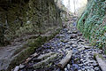
 View up in the Ruppertsklamm (2015) |
||
| location | Lahnstein , Rhineland-Palatinate , Germany | |
| surface | 14.83 ha | |
| Identifier | NSG 7141-001 | |
| WDPA ID | 82465 | |
| Natura 2000 ID |
(FFH), DE-5611-401 (SPA) DE-5613-301 (FFH), DE-5611-401 (SPA) |
|
| FFH area | 14.83 ha | |
| Bird sanctuary | 14.83 ha | |
| Geographical location | 50 ° 19 ' N , 7 ° 38' E | |
|
||
| Setup date | 1936 | |

The Ruppertsklamm is an approximately 1.2 km long gorge along a right tributary of the Lahn, originally called Michelsbach , in the area of the city of Lahnstein . It is located in the Niederwesterwald and overcomes a difference in altitude of about 235 m. It has been designated as a nature reserve since 1936 .
Surname
Originally the stream was called Michelsbach , the gorge didn't have a special name. Probably due to a misunderstanding during research, the Bachtal was first recorded as Ruppertsthal on the 1901 Coblenz map of the Prussian New Admission .
Michelbach (without s) is the name of another stream a few hundred meters further west today, which is not connected to the Ruppertsklamm.
Development
The gorge was made accessible to hikers between 1910 and 1912 by the railroad telegraphist and nature lover Theodor Zais, of which a memorial plaque commemorates halfway.
The lower entrance is on the B 260 to Bad Ems at the level of the former Hohenrheiner hut. A parking bay offers space for a few vehicles. The path up through the gorge leads as a mostly unpaved hiking trail always close to the stream, often changing sides over nine bridges and footbridges as well as some fords with stepping stones . In the steep middle section there are steps carved into the rock, here the path is secured with steel cables.
The upper end can be reached in 30 to 45 minutes on foot. There is a large, unmanaged refuge that offers seating for around 50 people and an open fireplace. Self-caterers can grill or light a fire here. Other hiking trails to Allerheiligenberg , Lichterkopf or Fachbach meet at the refuge .
With the Rheinsteig and the Lahnwanderweg , two long-distance hiking trails run through the Ruppertsklamm.
Other protected areas
The nature reserve, which is characterized by species-rich deciduous forest , is included in two significantly larger protected areas: The NSG area is also located in the European Lahnhang bird sanctuary (identifier DE-5611-401) and in the Lahnhang FFH area (DE-5613-301). As a result, the Ruppertsklamm - just like the surrounding forest areas - belongs to the European Natura 2000 network of protected areas .
The region and thus the Ruppertsklamm is part of the UNESCO World Heritage Upper Middle Rhine Valley .
photos

Lower entrance

Memorial plaque to Theodor Zais

Cliff path with safety ropes in the middle section
Stream bed in the gorge

Rock wall in the gorge

Refuge at the apex


See also
Individual evidence
- ↑ a b Ordinance on the "Ruppertsklamm" nature reserve from 1936. (PDF) In: www.naturschutz.rlp.de. Retrieved February 15, 2016 .
- ↑ Distance measured by router from the lower entrance to the upper crossroads
- ↑ Local history treatise by Dr. Fritz Michel, July 31, 1921, accessed March 12, 2018
