
Chew
| coat of arms | Germany map | |
|---|---|---|

|
Coordinates: 50 ° 5 ' N , 7 ° 46' E |
|
| Basic data | ||
| State : | Rhineland-Palatinate | |
| County : | Rhein-Lahn district | |
| Association municipality : | Loreley | |
| Height : | 74 m above sea level NHN | |
| Area : | 12.98 km 2 | |
| Residents: | 834 (Dec. 31, 2019) | |
| Population density : | 64 inhabitants per km 2 | |
| Postal code : | 56349 | |
| Area code : | 06774 | |
| License plate : | EMS, DIZ, GOH | |
| Community key : | 07 1 41 069 | |
| LOCODE : | DE KUB | |
| Association administration address: | Dolkstrasse 3 56346 St. Goarshausen |
|
| Website : | ||
| City Mayor : | Martin Buschfort (The Free) | |
| Location of the city of Kaub in the Rhein-Lahn district | ||
  |
||


Kaub (until 1933 written Caub ) is a town on the Rhine in the Rhein-Lahn district in Rhineland-Palatinate . It belongs to the Verbandsgemeinde Loreley , which has its administrative headquarters in St. Goarshausen . According to the number of its population with around 860 inhabitants, Kaub is the smallest town in Rhineland-Palatinate and is best known for the Pfalzgrafenstein Castle in the Rhine . The city has been part of the Upper Middle Rhine Valley UNESCO World Heritage Site since 2002 .
geography
Geographical location
Kaub is located on the right bank of the Rhine at river kilometer 546 and thus exactly in the middle between Mainz (river kilometer 500) and Koblenz (river kilometer 592). The city is picturesquely situated between the banks of the Rhine and the steep rocky slopes of the Rhenish Slate Mountains , into which the river has cut. At Kaub, the Volkenbach and the Holzbach cut two valleys with a steep gradient into the steep slopes that accompany the Rhine. In the intervening lying ridge of Kaub plate carries a rocky spur , the castle Gutenfels .
Pfalzgrafenstein Castle is built on the small rocky island in the Rhine near the Volkenbach Valley . The Kauber Werth begins one kilometer above this rocky island and is connected to it by a tail unit . It is next to the Wild Hazard , a former rapids on the Rhine. A few hundred meters further upstream at the Bacharacher Werth , the Niedertal ends on the banks of the Rhine, recognizable by two residential buildings there. The steeply rising valley floor of the Niedertal was for centuries the border between the Electoral Palatinate and the Rheingau (Kurmainz). After the Second World War, this was the zone boundary between the French zone of occupation , to which Kaub belonged, and the American zone of occupation . At the same time, the Niedertal became the state border between Rhineland-Palatinate and Hesse . Downstream, the Roßstein across from Oberwesel belongs to Kaub.
Between the Blüchertal , through which the Holzbach ( Blücherbach since 1894 ) flows, and the Niedertal , the Kauber city forest extends between Weisel and Sauerthal for 5 kilometers to just before the locality of Ransel . There are several abandoned slate pits in this area . In the city forest, the highest elevation in the Kauber district is located at a height of 424.8 m above sea level. NHN .
City structure
In addition to the urban area, Kaub has the following residential spaces :
- On the grove
- Gutenfels Castle
- Ernestine shaft in the Volkenbachtal
- Kauber plate
- Niedertal
- Racing team lugs
- Viktoriastollen (partially)
- Water house
Neighboring communities
The district boundary of Kaub is eight kilometers in the Rhine channel. On the opposite bank, Kaub borders Bacharach in the south and Oberwesel in the north . On the banks of the Rhine near the Urbach valley , Kaub shares a very short border with Sankt Goarshausen . The neighboring villages of Dörscheid and Weisel follow in the north . In the east there is a common border with the Lorch district of Ransel and with Sauerthal. The series of neighboring towns in the south is concluded with the Lorch district of Lorchhausen .
history
Prehistory and early history
The district was settled in prehistoric times. During excavation work on the thick tower, fragments of a clay vessel were found that are attributed to the Latène period around 500 BC. A Roman one-handled jug found during the construction of a wine cellar in the area of the Kauber train station is dated to around 260 AD. At the time of the Carolingians the area belonged to the Einrichgau .
There are various theories about the origin of the place name. It could be derived from the Celtic “cabi” (little house) or from the Latin “cubile” (deposit, slate warehouse) or “cupa” (wine barrel, vat). The legend traces the name back to the Mainz bishop Theonest . It is said to have been stoned by the Arian Teutons in 406, put into a perforated wine barrel (vat) and then pushed into the Rhine. The barrel was washed ashore at Kaub. In gratitude for his salvation, Theonest taught the residents Christianity and viticulture . In historical sources the place is sometimes written with a C and occasionally with a K. Medieval / early modern spellings handed down for the place name include: Cuba (983,1315); Cuoba (1250); Cubio (1255); Kuben (1257), Kawbe (1433); Kub (1434); Cub (1490); Caube (1581).
On June 14, 983, the place was first mentioned as "Cuba villula" (little village of Kaub) in a deed of donation from Emperor Otto II (donation from Verona) as a border town outside of the Rheingau.
Medieval Kaub
Around 1220, Cuba Castle (later Gutenfels) was built on a rock spur above the city. Knights or Burgmannen in Kaub ("in Kuben") have been mentioned in a document for the first time since 1241. In 1252, Kaub was besieged by King Wilhelm of Holland for several weeks without success.
In 1257, Philip I von Falkenstein - Münzenberg grants the Eberbach monastery duty-free on the Kauber Rhine toll . This is the first documentary mention of the customs post. In 1261, Cuba Castle ("castrum meum cuben") was first mentioned by name. In an arbitration award in the Falkenstein family, Kaub was first described as a walled city on August 19, 1275.
In 1277, Philipp II von Falkenstein-Münzenberg sells Castle Cuba and the fortified city below, with all rights, the church patronage to Weisel and all accessories, to Count Palatine Ludwig II the Strict for 2100 Aachen denarii . In 1287, Count Adolf von Nassau becomes Burgmann of the Count Palatine in Kaub. This is said to have received the news of his election as German king at Kaub Castle on May 5, 1292. Two years later, Count Wilhelm I von Katzenelnbogen was accepted into the line of Kauber Burgmannen.
A church in Kaub is mentioned for the first time in 1315. It was temporarily a branch church of the parish of Weisel. In 1324 Ludwig the Bavarian gave Kaub city rights like those of the city of Boppard. At this time, the city fortifications were expanded to include the market and bakery district in front of the old city wall. In the same year Ludwig the Bavarian donated the parish of Weisel to the Klarenthal monastery near Wiesbaden .
After the construction of Pfalzgrafenstein Castle (from 1326/27), Kaub became the most important customs office of the Counts Palatinate alongside Bacharach . The execution of the customs collection was incumbent on several officials with the customs clerk, the besehrer, the successor and the post clerk. The customs collection to Kaub was by Pope Johannes XXII. cited as the justification for the ban against King Ludwig of Bavaria.
In addition to customs, Kaub gained its importance in the course of time mainly through viticulture and until the mid-1980s through shipping and pilotage . The Kauber pilot station was the largest on the Rhine.
Presumably in the 1330s the city became an independent parish. A document from Count Palatine Rupprecht I. d. Ä. from 1353 documents the Kauber slate mining for the first time. Slate was a popular building material due to its weather resistance. Between 1368 and 1372 the Count Palatine maintained a mint in the city.
The customs quarter in the south was fortified in 1485–1487. For the first time a school in the village is documented for 1477.
Kaub had been the seat of the Electoral Palatinate from the 15th century . As a sub-office of the Oberamt Bacharach, it included Kaub and the villages of Weisel, Ober- and Niederdörscheid, Sauerthal as well as the Fronborn, Sauerburg, Rheinberg Castle, the Sachsenhäuser Hof (near Prath) and the wood field on the left bank of the Rhine.
The still preserved council and court minutes provide information about the city constitution of the 15th century. At the head of the city stood an elected mayor who was confirmed by the Electoral Palatinate bailiff. The mayor was supported by a legally trained town clerk. The city council (aldermen) consisted of six members. There was also the councilor and the common mayor. The council mayor was elected by the lay judges. He was responsible for managing the current official business. The common mayor was elected jointly by the quarter masters and the lay judges. He was responsible for a control function. The quarter masters were representatives of the city quarters: Bächerviertel, Linderviertel, Städterviertel and Zöllerviertel. The municipal jurisdiction was incumbent on the city court composed of mayor and lay judges. It had "neck and main jurisdiction" and was also responsible for property issues. The court had its own seal. This showed a blessing bishop over a stone wall with a round arched gate opening. The bishop is mistakenly interpreted as St. Theonest. However, the patron saint of Kaub is St. Nicholas, as is the oldest Kauber church bell “St. Nicholas ”from 1379. The medieval city constitution lasted until 1803.
The siege of 1504

As a result of the Landshut or Bavarian-Palatinate War of Succession , Kaub was besieged for 5½ weeks. In 1504, King Maximilian I commissioned Landgrave Wilhelm von Hessen to enforce the imperial ban on the Electoral Palatinate. The Landgrave began the siege of the town and castle of Kaub on August 18th. Although the Hessians took the castle and town under intense fire, they did not succeed in capturing them. As a result of a gunpowder accident, a fire broke out in the city, killing 11 people and destroying 20 buildings. On September 7th, the young Count Palatine Ruprecht arrived with his troops to reinforce the besieged at Kaub. The Hessians then withdrew, with considerable losses of people and guns. [The often read claim that Kaub Castle was renamed Gutenfels Castle after 1504 because of the brave defense is wrong. Even before its siege, the castle was referred to as “Guttnfels” and “Gudenfels” in the “Reißbuch” (war book) of the Electoral Palatinate. She must have come to this honorary name earlier.]
The legend of Elslein von Kaub , the daughter of the local gun founder, who disguised as a soldier, showed the Electoral Palatinate reinforcement troops the right way into the city , also belongs to this time . A memorial plaque at the administrative building recalls that Kaub remained in the Electoral Palatinate region despite 900 fired stone balls and 830 cast iron balls.
Early modern age
.jpg)
In the middle of the 16th century, the Reformation began in the Electoral Palatinate. The residents of Kaub converted to the new faith and the church system was extensively transformed. In 1578 90 citizens lived in the city.
During the Thirty Years' War , Kaub, as an important customs post for shipping on the Rhine, was repeatedly a conquest target for the warring parties. The Electoral Palatinate was a founding member of the Protestant Union .
The city was first conquered by Catholic Spanish troops in 1620 . In the winter of 1620/21 57 inhabitants died of the plague . In 1622 a pastor from Dörscheid, who represented the Protestant service in Kaub, was shot dead by a Spanish soldier in the pulpit or at the church door. There are no reliable documents. In the winter of 1624/25, 22 residents died of the plague. In 1631 Swedish troops and in 1632 Hessian troops stormed the city. In 1635 imperial troops occupied the place, the remaining inhabitants had fled to the surrounding area. A campfire that got out of control burned down numerous houses in the city district. In 1639/40 the town was again occupied by Swedish soldiers, in 1645 by French soldiers and in 1646 by imperial soldiers. Hessian troops conquered the place in 1647, but returned it to the Electoral Palatinate after the Peace of Westphalia .
The reconstruction work will take several years. In 1663 the town hall was restored. The restoration of the church organ is documented for 1684. Between 1684 and 1699 there was even a Latin school in the city. As a result of the Palatinate Church Simultaneum, a Catholic parish was founded in 1686, which used the town church together with the Protestant community. However, both communities had independent schools and cemeteries. The Jewish community also had its own cemetery on Schlossweg below Gutenfels Castle.
During the War of the Palatinate Succession , French troops advanced against Kaub in 1689, but refrained from looting the city after paying a substantial sum of money.
180 citizens and 32 widows are recorded in Kaub for the year 1742. Many citizens were involved in viticulture. There were also 133 traders. The most important branches of industry were slate mining and shipping on the Rhine. The slate of the Kauber slate train had the best quality in the Upper Middle Rhine Valley and was world famous.
In a storm disaster in 1748, two women died when the water from the Holzbach rushed to the valley. Several houses were badly damaged. Despite attempts to regulate the stream, severe water damage occurred again and again in the following years.
Since 1714 a post office of the Imperial Post Office operated by the Thurn und Taxis can be traced in Kaub.
During the First Coalition War , some Prussian battalions crossed the Rhine near Bacharach in March 1793 with the help of a pontoon bridge. On September 22nd, 1795, the French Revolutionary Army succeeded in conquering Gutenfels Castle.
After the Peace of Lunéville , Kaub came to the Principality of Nassau-Usingen . The city was part of the compensation Nassau was claiming for its losses on the left bank of the Rhine. On December 2, 1802, the official act of homage was carried out in Kaub. The seizure of ownership was legitimized by the Reichsdeputationshauptschluss 1803. The house of Nassau-Usingen was raised in 1806 as a reward for joining the Rhine Confederation to the Duchy of Nassau .
Blucher crossing the Rhine in 1814
On their march to France after the Battle of Leipzig in the Wars of Liberation , the Silesian Army gathered under the command of Field Marshal Blücher in December 1813 on the right bank of the Rhine on a width from Mannheim to Neuwied . The center of the army with Blücher and the Yorck and Langeron corps gathered above Kaub on the Taunus with the plan to advance from Weisel through the Holzbachtal and the city to the Rhine and cross it. On New Year's Eve 1813/14, the Kauber boatmen, reinforced by boatmen from St. Goarshausen, set an advance guard and the first troops in boats across the Rhine, while Russian pontoniers built a bridge from canvas pontoons. After the bridge was built, Blücher's army crossed the Rhine from January 2nd to 5th [5] . The Holzbachtal has since been known as the Blüchertal and the road that leads from Weisel to Kaub is called Blücherstraße .
At the same time as Blücher, the Sacken corps crossed the Rhine near Mannheim and the St. Priest corps between Neuwied and the mouth of the Lahn (near Lahnstein ) with a focus on Koblenz .
Duchy of Nassau
.jpg)

At the beginning of the 19th century there were 166 houses, three mills and a few outbuildings in the city. Floods regularly caused considerable problems in the area. The first half of the 19th century was characterized by particularly severe winters. According to records, the Rhine froze over almost every year between 1822 and 1847 (see Little Ice Age ).
With the incorporation of the city into the Duchy of Nassau, there were extensive administrative reforms. In 1805 a new local constitution was introduced. There was only a six-member city council and an annual mayor elected. The place was incorporated into the newly established St. Goarshausen Office in 1816 and lost its status as an official city. Tax law has been fundamentally redesigned. An official pharmacy was set up in the village in 1803 , the market fountain was supplied with water via a new lead pipe from 1810 and children of all denominations were taught together in the simultaneous school from 1817. On November 3rd, the Dutch “De Zeeuv” (The Zealander) came as the first steamship on the Middle Rhine to Kaub as far as the Sandweg not far from the Wild Vessel and returned to Holland. The Holzbach / Blücherbach was vaulted in 1828/29 and built over with a paved road.
The garrison in Gutenfels Castle was dissolved in 1804. The castle complex and the city towers were sold until 1807 or z. T. auctioned for demolition. Only the purchase of the castle ruins by the archivist Friedrich Gustav Habel in 1833 prevented its complete destruction.
In the Nassau era there was a strong expansion of slate mining. In 1823 there were 12 pits, in 1828 there were already 62 pits. The annual production was about 13,500 fissured shale. In the founding year of the Wilhelm-Erbstollen mine union in 1837, over 24,000 torn slates were mined in 131 pits, mostly underground. The listed site of the former Wilhelm Erbstollen mine still bears witness to the importance of mining for the city. The main tunnel of the Victoria mine gave its name to the Viktoriastollen district of Kauber . See also: [List of mines in the Taunus]
One consequence of the upswing was the increasingly narrow development of the local area, which allowed fire to spread very easily. In a fire in the town on October 7, 1843, a total of 25 of the town's 212 buildings were destroyed. Today's parking lot and memorial square in front of the two churches were built on the site of the burned-down buildings. Two years later, the simultaneous cemetery at the "Rauscheley", which is still in use today, was set up. On the initiative of Friedrich Gustav Habel, a trade school was opened in Kaub in 1846 . In the same year, a fire destroyed 22 buildings, including the pharmacy with the synagogue in the rear building. Another fire in the Zöllerviertel in 1848 destroyed over 30 buildings and left more than 60 families homeless.
In 1860 the sewer system in Kaub was expanded. The work ran at the same time as the construction work on the Nassau State Railroad (Rheintalbahn) from Rüdesheim to Oberlahnstein . This was opened to traffic in February 1862. In 1862 a private business school was established; it had to close again in 1879 due to financial difficulties.
Prussia
After the annexation of the Duchy of Nassau by Prussia , the place was part of Prussia from 1866 until the end of the Second World War. He belonged to the province of Hessen-Nassau and the administrative district of Wiesbaden. In 1866 the Prussian district and provincial order abolished the Nassau office division. Kaub initially belonged to the Rheingau district and from 1886 to the newly established district of Sankt Goarshausen . After the Prussian annexation, the Rhine toll was finally lifted on January 1, 1867.
At the beginning of the Prussian era, the new school and town hall was built from 1866 to 1868 according to plans by the building councilor Eduard Zais . 71 people from Kaub took part in the Franco-Prussian War.
In the Prussian era, as in other Prussian cities, the place name was written with a C after a decree of the Interior Ministry . It wasn't until the early 20th century that the spelling changed. [7] By resolution of the city council meeting of June 23, 1933, the spelling of the name of the city of Caub was changed to Kaub with K from January 1, 1934 . The change in the spelling of the Caub train station in Kaub came into effect on December 15, 1933. [8th]
Landslide in 1876

Even before 1876, rock movements had been detected on the steep slope above the town, which made it necessary to plan protective measures. Their costs were calculated at 150,000 marks, and the measures were to be implemented over several years.
As a result of persistent rain in the first two weeks of March 1876 , almost all rivers in the German Reich , including the Rhine, were flooded . In addition, due to the persistent heavy rain, the rising water pressure in the mountain interior at a point on the lower mountain slope, which had previously been considered from the technical side to be fixed and outside the movement, on March 10, 1876, the scree of the slate mountains had a width of 65 to 85 Meters detached. On the way down, this tore away the protective walls and buried five front houses in Hochstrasse and five rear houses in Zollstrasse at the foot of the mountain . This landslide killed 26 people.
For the permanent securing of the slope and to remove the rock debris and debris that had been in motion, total costs of 540,000 marks were estimated.
Local history in the empire
In October of the same year, five buildings in the village were destroyed by fire. Of the houses newly built after the landslide, three were destroyed in another landslide on February 9, 1879.
In 1888 the Gutenfels ruins were rebuilt. A fire in the Zöllerviertel in 1893 destroyed a total of eleven buildings. In 1900 a gym was inaugurated. The first kindergarten was also located in the building. A year later, the Kauber School reached the highest level in its history with 454 children.
The water supply was further expanded in 1904. In the same year, street lighting powered by acetylene gas was installed. For this a gas works had to be built in Kaub. In the following year the Kauber level tower was built. The landing stage of the Cologne-Düsseldorfer was established in 1909. A year later, the city was struck again by fire. Five of the town's 232 buildings burned down in Metzgergasse. With 233 hectares , Kaub had the largest wine-growing area on the Rhine.
During the First World War , 59 residents died in combat operations, and another 26 are missing.
Bottleneck Free State (1919–1923)
During the Allied occupation of the Rhineland after the end of the First World War, two bridgeheads with a radius of 30 kilometers each were formed on the right bank of the Rhine around Koblenz and Mainz , between which a narrow bottleneck remained unoccupied around Kaub , which was self-administered as the Free State of Bottleneck from 1919 to 1923 he was cut off from almost all connections to the territory of the Weimar Republic .
The Free State ended on February 25, 1923. French and Moroccan troops marched into Kaub . 24 residents of Kaub were expelled, six were arrested and one was shot.
20th century
In 1920 electric street lighting was introduced. As a result, the gas power plant could be demolished. The vacated space was later used for the Schiffer children's home.
Adolf Hitler and Paul von Hindenburg were declared honorary citizens of the city in 1933. This declaration was withdrawn after the National Socialist era by resolution of the city council.
During the Second World War , the area around the city was hit several times by Allied bombs. This damaged the Palatinate. Several people died in an attack on a passenger train in 1944. On March 26, 1945, American tanks entered Kaub at 2 p.m. That ended the war for Kaub.
Kaub was added to the French occupation zone and thereby came to the state of Rhineland-Palatinate .
In 1965 a new outdoor swimming pool called "Elsleinbad" was completed in Kaub.
In 1969, Kaub joined the newly created Rhein-Lahn district. Due to the local government reform of 1972, Kaub became part of the Loreley community .
The 1970s were marked by a decline in traditional industries in Kaub. With the expansion of the Rhine, pilotage became increasingly unnecessary. The acreage for wine sank to 71 hectares. The last slate quarries closed in 1972. In the following years there was a considerable decrease in population.
Population development
| year | Residents |
|---|---|
| 1578 | 90 citizens |
| 1654 | 198 inhabitants |
| 1814 | 1228 inhabitants |
| 1843 | 1501 inhabitants |
| 1885 | 2169 inhabitants |
| 1905 | 2028 inhabitants |
| 1939 | 2357 inhabitants |
| 1952 | 2554 inhabitants |
| 1982 | 1323 inhabitants |
| 2006 | 996 inhabitants |
| 2011 | 840 inhabitants |
politics
In elections to the German Bundestag, the place belongs to the Bundestag constituency of Koblenz (constituency 201). In elections to the Landtag of Rhineland-Palatinate , he belongs to the constituency of Koblenz / Lahnstein (constituency 8). Kaub is a member of the Loreley community, created on July 1, 2012 .
City council
The city council in Kaub consists of twelve council members, who were elected in the local elections on May 26, 2019 in a personalized proportional representation, and the honorary city mayor as chairman. Until 2009 the city council had 16 members.
The distribution of seats in the city council:
| choice | SPD | CDU | Free | FWG | KBL | WGR | total |
|---|---|---|---|---|---|---|---|
| 2019 | 4th | 3 | 5 | - | - | - | 12 seats |
| 2014 | 4th | 3 | 5 | - | - | - | 12 seats |
| 2009 | 3 | 2 | - | 3 | 4th | - | 12 seats |
| 2004 | 5 | 3 | - | 7th | - | 1 | 16 seats |
- FWG = Free Voting Group Kaub e. V.
- KBL = Kauber Bürgerliste e. V.
- Free = The Free - FWG Kaub / Kauber Bürgerliste e. V. (merger 2013)
mayor
The honorary city mayor is Martin Buschfort (Die Freie). In the direct election on May 26, 2019, he was elected with a share of the vote of 59.96% and is the successor to Karl-Heinz Lachmann (SPD), who did not run again after 10 years in office.
The first election of Karl-Heinz Lachmann as city mayor in 2009 took place in an unusual way. In a runoff election on June 21, 2009 against the incumbent incumbent Heribert Werr (KBL), who has been in office since 1989, each received 309 votes. Given the high number of votes counted, this stalemate situation, which was rare in view of the high number of votes, and the resulting necessary drawing of lots on the day after the election, attracted widespread media attention.
coat of arms

The current city coat of arms was awarded to the city on May 12, 1956. It is a quartered shield. In the right upper corner are the Wittelsbacher diamonds as a symbol of the 525 year membership in the Electoral Palatinate. The remaining fields have symbols that match the traditional professions represented in Kaub. Rhine and anchor for shipping and pilotage, grapevines with grapes for the winemakers and mallets and iron for slate mining.
The previous coat of arms of the city of Kaub referred to the Theonest legend. His blazon read: “In blue a bishop in a golden robe, with a silver miter and golden nimbus, with a raised right hand in blessing and a silver staff in his left hand, growing out of a perforated ship, on both sides of 2 golden angels, one of them on his right, the other stands on the crenellated turret. ”The coat of arms had been in use since 1907 and was officially approved in 1934. It went back to the court seal used from 1390 to 1761. Other preserved seals and city coats of arms also show figures of bishops interpreted as Theonest or Nicholas.
religion
In February 2018 the ten formerly independent parishes St. Martin ( Osterspai ), St. Margaretha ( Filsen ), St. Nikolaus ( Kamp-Bornhofen ), St. Jakobus the Elder ( Dahlheim ), St. Georg ( Kestert ), St. Martin ( Wellmich ), St. John the Baptist ( St. Goarshausen ), St. Nikolaus (Kaub), St. Peter and Paul ( Nastätten ) and St. Florin ( Strüth ) to the newly founded Roman Catholic parish “Heilige Elisabeth von Schönau ”, based in Kamp-Bornhofen, is part of the Limburg diocese .
Culture and sights


- The Castle Pfalzgrafenstein situated on an island in the Rhine. The island of the Palatinate itself does not have a special name, but is still often referred to in the literature as Falkenau, which has been scientifically refuted since 1878. The Rheinzollburg "Valckinowe" (Falkenau) was once near Gernsheim.
- As remains of the city fortifications , six main towers and the battlement between the old town hall and the Mainz gate tower have been preserved. This arcade-covered walkway is still accessible today and can be used as an emergency route in the event of flooding. The six towers are the Mainz gate tower (in the core of the 13th century, changed several times at times as half-timbered and with a battlement, today a hotel restaurant), today's church tower of St. Trinitatis , the thick tower or the thief tower (1485–1487, dome with twelve- sided wooden surrounds, privately owned since 1806), the Zollschreiber Tower in the inner courtyard of the Electoral Palatinate Office, the Weseler Tower and the Leiterberger Tower (Philippinenburg) in the middle of the vineyards on the northern slope of the Blüchertal Valley.
- The Blücher Monument was created by Fritz Schaper 80 years after the historic event and is located on the Rhine front. A small promenade with parks, cafes and restaurants runs here.
- The toll road (parallel to the Rhine River running, separated by the railway line from the promenade), the second boulevard of the town with some historical buildings, cafes and restaurants. In the old customs house (formerly "Golden Deer"), a half-timbered building, lived August Neidhardt von Gneisenau 1813/1814. Lieutenant Colonel Freiherr Ernst von Klüx took up quarters in the former Stadt Heidelberg inn (around 1780, formerly the seat of a winery) .
- The former customs office (Zollstrasse 42) was built on the old city wall in 1552 and served as the Electoral Palatinate office until 1803; since then it has been privately owned. The coat of arms of the Count Palatine near Rhine, which was embedded in the city wall, dates from 1485. Flood markings are placed in the inner courtyard with its half-timbered building, gallery and customs office tower.
- The Kurpfälzische Amtskellerei next door was already in the 14th century an official cellar, wine press, fruit house and salt store; the rear building in the inner courtyard with a stair tower stands on the walls of an older building. The main building on the street side dates from 1722 and served as an administrative authority for the Electoral Palatinate, later as a forest administration; it has been privately owned since 1969. The Apocalyptic Sun Woman from chapter 12 of the Book of Revelation is emblazoned above the entrance with the inscription Mulier amicta sole et luna sup pedibus eius (German: 'A woman clothed with the sun and the moon under her feet'). The Rheinsteig Youth Hostel , one of the most modern youth hostels in Germany, has been located in this building since summer 2010 .
- Some buildings of historical importance, which have been completely changed today, are located in Metzgergasse . No. 2 is the alleged birthplace of Elslein von Kaub . Nothing is left of the former Mainz cathedral courtyard from the earliest times in the city's history (No. 21). Maria Spes von Bielefeld, Baroness von Witzleben , acquired the building in 1734 and donated it to the Allerheiligen monastery in Oberwesel in 1755 . This building (rectory until 1802) burned down in 1876. The coat of arms of Baron Adam Heinrich von Witzleben , commandant at Gutenfels Castle in the years 1714–1751, and his wife Maria are still attached to the new building .
- The Blüchermuseum is housed in the former Gasthaus Zur Stadt Mannheim at Metzgergasse 6 (Quartier Blüchers). The wine merchant Jacob Meinhard Külp had a concession here since 1764 (Great Shield Justice).
- Opposite the small market square with the octagonal fountain, which is served by four water-spouting mascarons and crowned by a stone lion as a symbol of the house of Nassau in memory of Wilhelm I , and the pharmacy from 1803, the Protestant and Catholic churches are next to each other.
- The oldest part of the parish church is the 27 meter high five-storey tower that was part of the city fortifications. The original church building dates from the 12th century. The nave was rebuilt around 1440. This was consecrated since ancient times to the Holy Trinity ( St. Trinitas ), the choir, however, was under the patronage of St. Nicholas . From 1560 only Protestant services were held in the church. From 1687 Catholics and Protestants used the church together for 20 years after the Palatinate Church Simultaneum. When the choir arch was walled up in 1707, a double church was built . From then on, the Protestants celebrated their services in the nave of the Church of St. Trinity , the Catholics in the choir. This was demolished in 1771 in order to erect the Catholic Church of St. Nicholas on this site in 1772 as a late Rococo building with a roof turret for two bells and a St. Nicholas figure above the entrance. The most valuable piece of equipment was the so-called Cauber Madonna , an important sculpture from Rhenish late Gothic , which has been in the Hessian State Museum in Kassel since 1924 ; in the Catholic Church there is a true copy.
- The old town hall (Marktstraße 4) with its half-timbered upper floor is a reconstruction (1655–1663) of a building that burned down in the Thirty Years' War .
- Narrow streets lead to the upper areas of Hochstraße and Schlossweg.
- The Gutenfels Castle is located since 2007 in private ownership.
- A stud with a breed of thoroughbred Arabians is located on the Kauber Platte
- The Kauber boat mast on the banks of the Rhine near the level tower and the former pilot station.
- The first German Scooter Museum has been located in Gartenstrasse since summer 2010.
See also: List of cultural monuments in Kaub
Views of Kaub

Hotel "Zum Turm"

Kaub around 1900
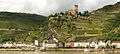
Gutenfels Castle above Kaub
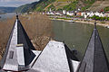
View from Pfalzgrafenstein Castle to Kaub

Ferry to Pfalzgrafenstein Castle, Kaub in the background
High water mark from March 1988 in Kaub


Economy and Infrastructure
traffic

Kaub is located on the railway line on the right bank of the Rhine , which is mainly used for freight traffic . In the passenger hold in Kaub regional trains. The federal highway 42 leads past Kaub between the city wall and the Rhine. Important passenger ships, such as those of the Cologne-Düsseldorfer Rheinschifffahrtsgesellschaft (KD), call at Kaub. A high-speed car ferry connects Kaub via Bundesstraße 9 with Oberwesel and Bacharach on the left bank of the Rhine. The road through the Blüchertal to Weisel is the southern starting point for trips to the Loreley plateau from Bornich and to Nastätten .
Kaub gauge

For navigation on the Rhine to destinations above Koblenz, the Kaub gauge is of central importance as a calculation variable. According to this, the possible loading depth and thus the immersion depth of the ship is measured for cargo shipping , especially at low tide . For example, you can load 80 to 120 cm to the Kaub gauge, depending on the willingness to take risks and the level trend (rising or falling).
The level tower and the high water marks I and II are at the height of the ferry ramp. The level zero point is at 67.66 above sea level , mark I at level 460 (72.26 above sea level) and mark II, at which shipping is stopped, at level 640 (74.06 above sea level), short below the top of the sea wall.
Tourism and hiking trails
Kaub benefits from moderate tourism with a few hotels, inns, guest houses and holiday apartments away from the stream of international guests on the Rhine, who concentrate on the Rheingau and the Loreley and usually go by ship to Kaub. Many car tourists on Bundesstraße 42 also only frequent Kaub as a transit point.
The dominant tourist themes are Blücher and Elslein . Some cafes and restaurants used to be named after Blücher. A contemporary Elslein is chosen every year as the counterpart of a wine queen common elsewhere .
- The Rheinsteig is a hiking trail from Biebrich Castle in Wiesbaden to Bonn via the Loreley , the Enemy Brothers ( Liebenstein and Sterrenberg ) and Lahneck Castle .
- The Hessenweg 7 has its starting point in Kaub. It leads over 204 kilometers to Erbach in the Odenwald .
Viticulture
Viticulture in Kaub is subsumed under the Herrenberg site within the Middle Rhine region . The individual layers are called Ofen, Blüchertal, Pfalzgrafenstein, Rauschelay and Roßstein . The steepest vineyards around Gutenfels Castle have been re-cultivated since 2008 after extensive land consolidation. The Burg Gutenfels vineyard site lay fallow for years and was becoming increasingly overgrown, which was very detrimental to the landscape. Further vineyards lie north of the village, which are cultivated by family wineries with around 60% Riesling , 30% Pinot Noir and 10% other grape varieties. Predicate levels up to Beerenauslese are achieved, especially from the Riesling variety. In addition to wine production, the local businesses also produce brandy and pomace brandy .
Personalities
Sons and daughters of the city of Kaub
- Johann Wonnecke von Cube (around 1430–1504) Herbal Book Hortus Sanitatis , City Doctor in Frankfurt a. M.
- Dietrich von Cube (1435–1474) German order, papal legate, bishop of Samland
- Joh. Hochgesang von Geyse (Hans Schmydt von Cube) (around 1405 / 10–1474) gunsmith, clock bellman and inventor
- Jacob Müller (1779–1856) teacher and chronicler
- Heinrich Kessler (1834–1915) locomotive driver, inventor and manufacturer
- Leonhard von Bonhorst (1840–1915), politician and first party secretary of the SDAP
- Karl Joseph Wilhelm Juchheim (1886–1945), confectioner and company founder in Japan
- Patrik Kimpel (* 1967), cook
People who worked on site
.jpg)
- Adam Heinrich von Witzleben (1673–1751), builder of the Mainz cathedral courtyard in Kaub
- Gebhard Leberecht von Blücher (1742–1819), Field Marshal General, 1813/1814 crossing the Rhine at Kaub with his army
- Ludwig Yorck von Wartenburg (1759–1830), General Field Marshal, 1814 crossing the Rhine at Kaub as General of the Infantry
- Franz Friedrich Karl Ernst von Klüx (1776–1858), at that time lieutenant colonel and city commandant, preparer of Blücher's crossing of the Rhine
- Erich Nikutowski (1872–1921), landscape painter from the Düsseldorf School , “uncle painter” in the Mainz Tower
- Karl Hahn (1867–1953), teacher and writer
- Albert Scheinpflug (1888–1971,) dentist and local researcher
literature
- Magnus Backes : Kaub am Rhein with the Gutenfels Castle and the Pfalzgrafenstein. Rheinische Kunststätten booklet 43. 2nd edition. Neuss 1976.
- Bruno Dreier: New Year 1813/14: With Blücher at Kaub across the Rhine. 6th corrected edition. Self-published, Kaub 1996.
- Wilhelm Kimpel: The helmsmen and pilots on the mountain stretch of the Middle Rhine with their stations in Bingen, Kaub and St. Goar. 2nd ext. Edition. Kaub 1999, ISBN 3-929866-04-8 .
- Werner Schäfke : The Rhine from Mainz to Cologne. DuMont art travel guide. Cologne 2006, ISBN 3-7701-4799-5 .
- Christian Daniel Vogel : Description of the Duchy of Nassau . Beyerle, Wiesbaden 1843.
- Kurt Dehe: 1000 years of Kaub 983-1983 . Ed .: City administration Kaub. Mönch-Verlag, Koblenz / Bonn 1983.
- The large book of arms of the Loreley community. Verbandsgemeinde Loreley (Ed.). St. Goarshausen 1994.
- Georg Dehio : Handbook of the German art monuments. Rhineland-Palatinate and Saarland. Hans Caspary, Wolfgang Götz, Ekkart Klinge (arr.). Munich u. Berlin (1967) 1972.
- Karl Ernst Demandt (edit.): Regesten der Grafen von Katzenelnbogen 1060–1486, 4 vol. Publications of the Hist. Commission for Nassau 11. Wiesbaden 1953–1957.
- Karl Ernst Demandt / Renkhoff, Otto (arrangement): Hessisches Ortswappenbuch. Double volume 1 and 2. Glücksburg 1956.
- Kappus, Christian / Struck, Wolf Heino: Kaub, Loreley Circle. In: Keyser, Erich (ed.): City book of Rhineland-Palatinate and Saarland. Stuttgart 1964.
- Koch, Adolf / Wille, Jacob (arr.): Regesten der Pfalzgrafen am Rhein 1214-1400. Baden Historical Commission (ed.). Innsbruck 1894.
- Menzel, K. / Sauer, W. (Eds.): Codex diplomaticus nassoicus [Nassau document book]. 1. Vol. 1. – 3. Abt., Wiesbaden 1886–1887.
- Upper Middle Rhine Valley. Topographic leisure map 1: 25,000. State Office for Surveying and Basic Geographic Information Rhineland-Palatinate and Hessian State Office for Soil Management and Geoinformation (ed.). 3. Edition. Koblenz 2008.
- Rang, Helmut / Schick, Manfred u. a .: Loreley district Montabaur district. In: The districts in Rhineland-Palatinate. Central Committee for German Regional Studies (ed.). Vol. 5, Speyer 1965.
- Sponheimer, Meinhard: State history of the Niedergrafschaft Katzenelnbogen and the adjacent offices on the facility. Marburg 1932.
- Johann Goswin Widder : Attempt of a complete geographic-historical description of the Kurfürstl. Palatinate on the Rhine. 3rd part. Frankfurt and Leipzig 1787.
Documents
- Image by Pfalzgrafenstein from JF Dielmann, A. Fay, J. Becker (draftsman): FC Vogel's Panorama of the Rhine, images of the right and left banks of the Rhine, FC Vogel lithographic institution, Frankfurt 1833
- Picture by Kaub from JF Dielmann, A. Fay, J. Becker (draftsman): FC Vogel's panorama of the Rhine, pictures of the right and left banks of the Rhine, FC Vogel lithographic institution, Frankfurt 1833
- Image 2 by Kaub from JF Dielmann, A. Fay, J. Becker (draftsman): FC Vogel's panorama of the Rhine, images of the right and left banks of the Rhine, FC Vogel lithographic institute, Frankfurt 1833
Web links
- City of Kaub
- Tourist office of the city of Kaub
- Heimat- und Kulturverein Kaub: Historical information about Kaub
- Historical information about Kaub at regionalgeschichte.net
- Historic Free State of Bottleneck 1919–1923
Individual evidence
- ↑ State Statistical Office of Rhineland-Palatinate - population status 2019, districts, communities, association communities ( help on this ).
- ↑ a b c d Topographic map 1: 25,000
- ↑ State Statistical Office Rhineland-Palatinate (ed.): Official directory of the municipalities and parts of the municipality. Status: January 2018 [ Version 2020 is available. ] . S. 45 (PDF; 2.2 MB).
- ↑ Die Stadt Kaub , on www.vgloreley.de, accessed on July 26, 2018
- ↑ see section History near Cologne
- ^ The landslide on March 10th, 1876 . Homepage City of Kaub ( Memento from January 3, 2019 in the Internet Archive )
- ↑ Nothstandsvorlage the Prussian state government for the prevention of a further landslide at Caub am Rhein
- ^ The Regional Returning Officer Rhineland-Palatinate: Municipal Council Election 2019 Kaub. Retrieved November 2, 2019 .
- ^ The Regional Returning Officer Rhineland-Palatinate: Municipal elections 2014, city and municipal council elections
- ^ The State Returning Officer Rhineland-Palatinate: direct elections 2019. see Loreley, Verbandsgemeinde, eighth line of results. Retrieved November 2, 2019 .
- ^ Thorsten Herdickerhoff: Mayoral election in Kaub - SPD in luck. Frankfurter Rundschau, June 23, 2009, archived from the original on November 17, 2016 ; accessed on November 2, 2019 .
- ↑ State Statistical Office: direct elections of the local and city mayors as well as the mayors ( Memento of November 16, 2016 in the Internet Archive )
- ↑ www.rhein-zeitung.de: Founding service: Parish "Heilige Elisabeth von Schönau" has its seat in Kamp-Bornhofen , accessed on February 6, 2018.
- ↑ Kauber Platte Stud
- ↑ Kaub gauge at ELWIS ( Memento of the original from November 16, 2016 in the Internet Archive ) Info: The archive link was automatically inserted and not yet checked. Please check the original and archive link according to the instructions and then remove this notice.

Allendorf | Altendiez | Arzbach | Attenhausen | Auel | Aull | Bad Ems | Balduinstein | Becheln | Mountain | Berghausen | Berndroth | Bettendorf | Biebrich | Birlenbach | Bogel | Bornich | Braubach | Bremberg | Book | Burgschwalbach | Charlottenberg | Cramberg | Dachsenhausen | Dahlheim | Dausenau | Dessighofen | Dienethal | Diethardt | Diez | Dörnberg | Dornholzhausen | Dörscheid | Dörsdorf | Ebertshausen | Honor | Eisighofen | Endlichhofen | Eppenrod | Ergeshausen | Eschbach | Fachbach | Filsen | Flat | Fruit | Geilnau | Geisig | Gemmerich | Gückingen | Gutenacker | Hahnstätten | Hainau | Hambach | Heistenbach | Herald | Himmighofen | Hirschberg | Holzappel | Holzhausen an der Haide | Holzheim | Hömberg | Horhausen | Hunzel | Isselbach | Kaltenholzhausen | Kamp-Bornhofen | Kasdorf | Katzenelnbogen | Kaub | Kehlbach | Kemmenau | Kestert | Klingelbach | Kördorf | Lahnstein | Langenscheid | Laurenburg | Lautert | Liiffer | Lipporn | Lohrheim | Lollschied | Lykershausen | Marienfels | Miehlen | Mielle | Misselberg | Mittelfischbach | Mudershausen | Nassau | Nasta | Netzbach | Niederbachheim | Niederneisen | Niedertiefenbach | Niederwallmenach | Never | Nochern | Oberbachheim | Oberfischbach | Oberneisen | Obernhof | Obertiefenbach | Oberwallmenach | Oberwies | Oelsberg | Osterspai | Patersberg | Pohl | Prath | Reckenroth | Reichenberg | Reitzenhain | Rescue Grove | Rescues | Roth | Ruppertshofen | Sankt Goarshausen | Sauerthal | Scheidt | Schiesheim | Schönborn | Schweighausen | Seelbach | Singhofen | Steinsberg | Strüth | Sulzbach | Wasenbach | Weidenbach | Weinähr | Weisel | World destruction | Weyer | Winches | Winter advertising | Room difference