
Rhine shipping

The Rhine has due to the traffic strategic location of the Rhine and between important economic and industrial areas of Europe - not only in modern times - a long and distinguished tradition. Today the Rhine between Basel and its confluence with the North Sea is one of the busiest waterways in the world. Accordingly, there are extensive provisions and agreements that regulate shipping traffic on the Rhine.
history

The Rhine was already an important water and trade route in Roman times . The river trade at that time used a type of river barge that was about 30 m long and 9 m wide and had a draft of about 70 cm. Such a ship, both rowed and sailed, could carry 100 to 150 tons of cargo. Around 13 BC The Classis Germanica , one of the largest naval associations of the Roman Empire, was set up on the Rhine . Until the invention of the steamship, people and goods were transported on the Lower Rhine by flat-keeled sailing ships . In Cologne (Dutch banks / Oberlander banks), they were transferred to smaller barges, which then by horses or by human power on ropes from the towpath from both banks towed were. Before the river was tamed and deepened by hydraulic engineering, towing up the mountain was not always easy. Difficult, rocky places often had to be avoided. The customs barriers ( Rheinzölle ) set up by the territorial lords were also gladly avoided . The High Rhine between Schaffhausen and Basel reached at the beginning of the modern era at its peak.
Today the Rhine is the preferred (because cheapest) transport route for bulk goods and container ships .
After the Congress of Vienna , a commission met in Mainz in 1816 (later the Central Commission for Navigation on the Rhine ) to work out a joint agreement between the states on the banks of the Rhine for navigation on the Rhine. With the Rhine Shipping Act of March 31, 1831 (Mainz Act), freedom of navigation was guaranteed to the open sea, the stacking rights in Cologne and Mainz were abolished and the riparian states were obliged to remove barriers to shipping. In order to make the Rhine reasonably navigable at all, the Upper Rhine was straightened from 1817. With the revised Rhine Shipping Act Mannheim Act of October 17, 1868, shipping was, among other things, exempted from fees and charges that were based solely on the fact of the ship. Also Rhine courts were established. It was stipulated that all signatory states - including all those bordering the Rhine and Great Britain - apply the same laws and the same approval criteria for means of transport , and that the navigability of the Rhine downstream from Basel must be ensured. For example, anyone planning a new power station would have to create a free bypass option.
The Central Commission for Navigation on the Rhine has been housed in the Palais du Rhin in Strasbourg since 1920 . Switzerland, France, Germany, the Netherlands and Belgium are represented in it.
On the difficult fairway of the "mountain route" from St. Goar to Bingen , a local Rhine pilot was called in as a helmsman until the 1980s . On the route from Mannheim to Iffezheim lock, pilots are still operated at times.
Shipping accidents
In 1958 the coal-laden "Birsigtal" capsized near the Mittlere Brücke in Basel.
On October 7, 1960 there was a collision near Emmerich between the Danish ferry Tina Scarlett , which was towed to the valley, and the tanker Diamant, which was loaded with 1,100 m³ of petrol . Large amounts of gasoline leaked and ignited. A total of ten ships burned. The Rhine was on fire at a width of around 300 meters. The tanker sank, the ferry ran aground and later sank. Two people died and 22 were injured, some seriously. The reason for the accident was a rudder failure on the Tina Scarlett .
Also in October 1960 the tanker "Padella" capsized near the Johanniterbrücke in Basel.
At the chemical company BASF in Ludwigshafen am Rhein there was an explosion in March 1970 on the tanker St. Jürgen loaded with benzene . The burning, leaking benzene turned the Rhine into a sea of flames almost as far as Worms . The accident claimed five lives.
September 28, 1984, in Basel: The tug "Vogel Gryff" pushed the barge "Corona" loaded with 971 tonnes of clay upstream, under the Middle Bridge. The tug hit a pillar of the bridge and the vehicle got out of control. The current pushed the barge to the left against the bridge piers. For almost three weeks, the "Corona" lay across the direction of travel and prevented shipping to Birsfelden and Rheinfelden. The salvage work attracted countless onlookers.
In an accident on April 5, 1998, of three ships in thick fog near the Düsseldorf district of Kaiserswerth , a tanker exploded, causing considerable property damage. People were only slightly injured. The Rhine had to be closed for over ten hours.
On May 7, 1999, when filling gasoline, there was an explosion on the Bayer Erdölchemie tanker bridge in Dormagen . An inland tanker on the Rhine and another ship caught fire. 750 tons of the gasoline mixture ended up in the river. Three people died, ten people were injured, some seriously.
On the morning of January 13, 2011, the tank motor ship Waldhof, loaded with 2,377 tonnes of sulfuric acid, had an accident in the Rhine near St. Goarshausen not far from the Loreley. Two of the four crew members were killed. As a result of the accident, the Rhine had to be temporarily closed completely at the height of the ship that had crashed. The last of 420 pent-up ships were only allowed to pass the scene of the accident three and a half weeks after the accident.
navigability
From Breisach to shortly before Basel, shipping and most of the Rhine water is led through the Rhine side canal, which lies entirely on French territory , the rest of the Rhine forming the border is of no importance for shipping. Due to the structural measures from Rotterdam to Rheinfelden (the one in Aargau and that in Baden-Württemberg), the Rhine can now be navigated without problems. Above, there are slip or other transfer systems at the barrages for small ships, and locks at the Laufenburg and Eglisau power plants for vehicles up to 2.20 m × 10 m, sometimes significantly more. Above the Rhine Falls, the Rhine is closed to all shipping traffic up to the bridge at Neuhausen am Rheinfall . Above the Rhine bridge in Schaffhausen there is a continuous boat connection to Constance in the summer months . The weir in Schaffhausen ensures a constant water level up to Diessenhofen . The bridge at Diessenhofen is very low, and some ships “sink” the driver's cabin for passage. The Rhine is not regulated as far as Stein am Rhein , so it is only navigable depending on the water level. Also, the Lake is very popular with sailors and navigable. The Alpine Rhine is closed to shipping, but the Old Rhine is navigable for two kilometers from the mouth to Rheineck SG.
In the 1950s and 1960s there were plans to make the Rhine navigable as far as Eglisau . In view of these plans, Migrol built an underground tank farm in the "Tössriederen" area. The landing stage was never built; and the petroleum products were transported by road.
Ports
The most important commercial Rhine ports on the Upper, Middle and Lower Rhine are: Basel , Strasbourg , Kehl , Karlsruhe , Wörth am Rhein , Germersheim , Speyer , Ludwigshafen , Mannheim , Worms , Gernsheim , Mainz , Lahnstein , Koblenz , Bendorf , Andernach , Godorf / Wesseling , Cologne-Niehl , Leverkusen , Dormagen , Neuss , Düsseldorf , Krefeld , Duisburg-Ruhrort , Orsoy , Walsum , Rheinberg , Wesel , Emmerich am Rhein , Nijmegen , Dordrecht and Rotterdam .
Canal connections to other rivers

The Rhine has connections to other rivers via canals:
- The Rhine-Rhône Canal branches off from the Rhine Lateral Canal between Kembs and Niffer . Since the mid-1990s it has been navigable for European ships from there to Mulhouse , this section is sometimes referred to as the Mühlhauser Canal (Canal de Mulhouse). Until a restructuring in the early 1960s, there were also connections to Mulhouse via the Hüningen Canal from the town of the same name and from the Neu-Breisach and Strasbourg areas. These have now been shut down in sections. So still available are only interesting for tourism.
- The Rhine-Marne Canal ( Canal de la Marne au Rhin ) connects with two canal tunnels over two watersheds Strasbourg over the Moselle and Marne with the Seine near Paris , only suitable for pleasure craft and smaller ships
- From Duisburg the Rhine-Herne Canal and from Wesel the Wesel-Datteln Canal connect the Rhine via other canal and river systems with the Ems , Weser , Elbe and Oder .
- The Meuse near Venlo was to be connected with the Fossa Eugeniana from Rheinberg in 1626 and, according to Napoleon's will, in 1809 by the northern canal from Neuss . Both projects were started but not completed.
- The Maas-Waal Canal branches off in Nijmegen (km 887.1) .
- From Tiel (km 913.5) the Amsterdam-Rhine Canal connects the Waal with Amsterdam .
- At km 926.1 there is a connection to the Maas via the Sint Andries Canal .
- At Woudrichem (km 925.5) is the access to the Afgedammte Maas.
- In Gorinchem (km 955.5) the Merwede Canal branches off to the Amsterdam-Rhine Canal .
level

The current water levels are regularly retrieved from the Rhine gauges . The measured values are transmitted to the responsible waterways and shipping offices and directorates as well as to the Federal Institute for Hydrology in Koblenz . Automatic answering machines are also available for everyone (in Germany: area code plus 19429), through which Rhine boatmen and the population can find out the water levels and their trend. The water levels and provide more information on the Internet, the el ektronische W asserstraßen- I nformation s ystem . and level online.
Water levels
For the assessment of the fairway conditions, the equivalent water level (GlW) applies at a number of guide gauges. The equivalent water levels are the water levels that occur in the case of discharges determined as equivalent along a stretch of river. They represent a low water level, which is below the long-term average on twenty ice-free days a year at the respective reference levels. Because of the natural changes in the river bed (deposits or erosion), the GlW is redefined every ten years by the Central Commission for Navigation on the Rhine (CCNR). At the moment, the equivalent water levels from 2012 apply. The Dutch authorities determine the GlW for their level themselves in consultation with the German authorities.
The Federal Waterways and Shipping Administration endeavors to maintain, restore or even improve the following fairway depths related to GlW 2012:
- from Krefeld (km 763.0) to the valley 2.80 m
- from Krefeld to Berg to Koblenz (mouth of the Moselle) (km 592.2) 2.50 m
- from Koblenz (mouth of the Moselle) to St. Goar (km 557.0) 2.10 m
- from St. Goar to Budenheim-Niederwalluf (km 508.0) 1.90 m 1 and
- from Budenheim-Niederwalluf to Iffezheim lock (km 334.0) 2.10 m
Equivalent water levels 2012 [cm] at the reference levels:
|
|
The following 31 important shipping gauges exist on the Rhine: Konstanz , Basel-Rheinhalle , Iffezheim , Maxau , Speyer , Mannheim , Worms , Mainz , Oestrich , Bingen , Kaub , Koblenz , Andernach , Oberwinter , Bonn , Cologne , Düsseldorf , Duisburg-Ruhrort , Wesel , Rees , Emmerich am Rhein , Lobith , Pannerdense Kop , IJsselkop, Nijmegen Hafen, Tiel , Zaltbommel , Vuren , Krimpen , Dordrecht and Rotterdam .

The most important gauges for shipping within the free-flowing Rhine route are Maxau, Kaub and Duisburg-Ruhrort. Duisburg is relevant for the route to Koblenz, Kaub and Maxau for southern destinations. Ships entering the Wesel-Datteln Canal count on the Wesel level. The water levels at the gauges (colloquially also for short: water levels) are important for the loading depth and thus the diving depth at low tide . For example, you load 80 to 120 cm onto the Kaub gauge, depending on your willingness to take risks. If necessary, must be a port of call for the ship easier . For uphill travel on the Middle Rhine, for example, this was possible up to the 1970s in Bad Salzig for tankers and in St. Goarshausen for other cargoes, today this practice has lost its importance. If the ships can no longer carry the full load, the freight becomes more expensive. For this reason, a small water surcharge (Kwz) is levied for cargo shipping at certain water levels at the Duisburg-Ruhrort, Cologne and Kaub gauges:
- Kwz. Kaub gauge from 150 cm for southern ports
- Kwz. Cologne gauge from 195 cm for ports between Koblenz and Cologne
- Kwz. Duisburg-Ruhrort gauge from 270 cm for ports north of Cologne to Duisburg
- Kwz. Emmerich gauge from 70 cm for all ports downstream from Duisburg.
All navigation gauges on the Rhine have a high water mark I and II. At high water mark I, according to the Rhine Shipping Police Ordinance ( RheinSchPV ), in order to avoid damage to the banks, all vehicles, with the exception of small vehicles without a machine drive, must stay in the middle of the fairway when downhill and in the middle third of the river when uphill. The width of the stream is the distance between the bank lines. When driving, including overtaking, a maximum of two ship or formation widths are permitted. The maximum speed of the vehicles must not exceed 20 km / h opposite the bank. Only those vehicles that are equipped with a radiotelephone may continue their journey within the corresponding section of the route. This is monitored by the water police. When the high water mark II is reached, shipping is completely blocked in the relevant area (the corresponding high water marks are described e.g. at Cologne level ).
Fairway depths
The desired water depths are not always available. It should be noted that these depths do not extend to the entire width of the river, but only to the navigation channel, so that especially towing trains and longer push convoys must avoid getting too close to the limits of the fairway or crossing them when unloading deeply. The responsible waterways and shipping directorate announces at certain time intervals, as soon as there are significant changes, which shallow water depths have been determined by bearings on individual sections.
When unloading the ships, it must always be ensured that the channel depths resulting from the level readings and the notifications of the waterways and shipping directorates only indicate the available depths, but not the maximum permissible immersion depth of the ships; Depending on the nature of the river bed (rock or gravel), the design of the vehicles, the amount of cargo, the height and tendency of the water levels, this is in any case less than the bed depth. The Federal Waterways and Shipping Administration generally refuses to give the shipping operators any regulations or advice on the size of the unloading.
On the basis of Sections 1.04 and 1.06 of the RheinSchPV , the skipper must determine the draft of his ship on his own responsibility, taking all circumstances into account, in particular the draft during the journey (lowering due to screw suction) and the possible danger in connection with the cargo.
The responsibility of the officials of the "competent authority" (water police or water and shipping authority) to issue instructions to the boatmen in accordance with § 1.19 RheinSchPV remains unaffected. In this way, vehicles that are too deeply loaded and which endanger the safety, orderliness and the speed of shipping can be prevented from continuing their journey.
In passenger ships , the draft can hardly influence. The skipper decides on his own responsibility whether the fairway depth required for his vessel is still given at low tide. In 2003 there was a spectacular ship accident on the Rhine due to grounding in passenger shipping during extremely low water .
Locks on the Upper and Upper Rhine


From Augst to Birsfelden (Upper Rhine) and from Kembs to Iffezheim (Upper Rhine) the Rhine has 12 steps.
| Surname | Rhine km | Lock dimensions (m) | Height of fall (m) |
|---|---|---|---|
| Augst (CH) | 155.50 | 110.00 x 11.45 | 4.63 to 6.65 |
| Birsfelden (CH) | 163.43 | 187.50 x 11.45 and 180.00 x 11.45 | 5.91 to 9.28 |
| Kembs (F) | 179.10 | 185.00 × 22.80 and 186.50 × 22.80 | 14.26 |
| Ottmarsheim (F) | 193.64 | 185.00 x 22.80 and 185.00 x 12.50 | 15.50 |
| Fessenheim (F) | 210.51 | 185.00 x 22.80 and 185.00 x 12.50 | 15.70 |
| Bird green (F) | 224.54 | 185.00 x 22.80 and 185.00 x 12.50 | 12.30 |
| Marckolsheim (F) | 239.88 | 185.00 x 22.80 and 185.00 x 12.50 | 13.20 |
| Rhinau (F) | 256.15 | 185.00 x 22.80 and 185.00 x 12.50 | 13.30 |
| Gerstheim (F) | 272.23 | 185.00 x 22.80 and 185.00 x 12.50 | 11.75 |
| Strasbourg (F) | 287.36 | 185.00 x 22.80 and 185.00 x 12.50 | 13.25 |
| Gambsheim (F) | 308.83 | 270.00 × 22.80 and 270.00 × 22.80 | 10.35 |
| Iffezheim (D) | 334.00 | 270.00 × 24.00 and 270.00 × 24.00 | 10.30 |

Ottmarsheim lock
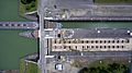
Ottmarsheim lock
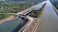
Marckolsheim lock

Rhinau lock


Truth and traffic rules

In the technical jargon of sea and inland waterway shipping, "truth" means something like "attention" or "caution". The word is related to the Dutch word waarschuwing (warning) .
Shipping police truth
Fixed landmarks
On the 5 km long, deeply cut, strongly winding and narrow Rhine route between Oberwesel and St. Goar, certain vehicles must be avoided in the curves. Since neither sufficient visual contact nor interference-free radio communication is possible for the ships, signal points have been set up on the bank since 1972 for light viewing, i.e. to regulate ship traffic with the aid of light signals. For the descent there are the signal points A Am Ochsenturm near Oberwesel and B “Am Kammereck”, for the ascent E “An der Bank” near St. Goar, D “Opposite the Loreley” and C “Am Betteck”. Since 1997, the light signals are centrally from the traffic center Oberwesel, as an organ of the Marine Police Department Federal, using four land-based radar stations connected (§ 12.2 RheinSchPV).

See also: Wahrschau am Mittelrhein , shallows of the Rhine
Floating landmarks

Probation rafts are anchored at special temporary danger spots, such as ship accidents, dredging work or temporary lack of depth. Perception rafts are about 5 × 3 meters in size, painted yellow, with devices for attaching navigation signs by day and night to regulate traffic with the signs “no passage” and “passage free” (§ 6.08 RheinSchPV). If necessary, the traffic is also monitored by the state's water police on behalf of the federal government.

Private viewers or order stations
Private spectators inquire about or explore the ship's positions. This information is passed on to the relevant freight forwarders or shipping companies for a fee. Example: The cargo is sold en route, it now has a different owner and possibly a new port of destination. Or: The shipping companies want to know when their ship is where. On the entire Rhine, from Mothern to Dordrecht , only a few of the former 30 order stations were preserved until the 1970s, on the Lower Rhine only one of the former nine. The modern communication options make a "new order" superfluous.
Traffic rules
Detailed traffic rules apply on the Rhine. Without these, such a dense traffic of different vehicles would not be possible. The rules are contained in the Rhine Shipping Police Ordinance (RheinSchPV), the "Road Traffic Regulations" for the Rhine, which are drawn up by the Central Commission for Navigation on the Rhine and adopted by the riverside states in their own national law. The most important of these are:
- From Rhine kilometer 769 (Duisburg-Ehingen) to the German-Dutch border, the "regulated encounter" takes place ( port to port encounter ), the descent goes down on the right bank to the valley, the ascent on the left bank to the mountain.
- Above the Rhine kilometer 769, the ascent of the descent shows the way. Here the descent and ascent change sides depending on the course of the fairway. If two ships meet on starboard ("left-hand traffic"), a blue square board is unfolded to the right (starboard). This board is coupled with a white twinkling light (flashing light) for driving at night.
- There is also the “regulated encounter” from the mouth of the Neckar (km 428.2) to Lorch (km 540.2), and after that a “right-hand drive” applies up to km 556.0, which means that the center line of the fairway must not be crossed .
- The ship's name and a 7-digit official ship number or, now, an 8-digit European ship number (ENI) are attached to the stern for identification. The name of the home or register location is either on both sides or on the stern of the ship. On both sides of the bow there is only the name of the ship. On the long sides the information for the size (tonnage), length and width are added.
- The draft indicators, divided into decimeters, are on the left and right of the ship's side.
- The "calibration mark" is welded above the indicated displays.
- The flag of the home country is set on the stern, the shipping company flag, also called the "driving flag", on the front mast.
- Blue signal lights or "blue cones" indicate the transport of dangerous goods (according to ADNR) by tankers or dry freighters.
- Signal lights: masthead light in white, port light red and starboard light green, on the sides of the wheelhouse. Tail light white, aft at the stern.
- In the event of an accident, a red and white flag is set.
- Towing convoys are marked with a yellow-black bucket and a yellow ball.
Compliance with these rules is monitored by the shipping police in the respective countries.
In 2000, Germany and France agreed to cooperate in the performance of shipping police duties for the stretch on the Upper Rhine, on which the Rhine forms the border between the two countries. As a result, the Franco-German water police (Compagnie fluviale de gendarmerie du Rhin) was set up with its headquarters in Kehl and branches in Gambsheim and Vogelgrun , which provides its service with its own boats and mixed crews.
See also
Web links
- Rhine Shipping Police Ordinance (RheinSchPV) (PDF file; 196 kB)
- The Rhine in detail, route description
- Central Commission for the Navigation of the Rhine
literature
- Wilhelm Kimpel: The helmsmen and pilots on the mountain stretch of the Middle Rhine with their stations in Bingen, Kaub and St. Goar. 2., ext. Edition. Kaub 1999, ISBN 3-929866-04-8 .
- Josef Dollhoff: Rhine shipping - excursions into the history of the great river. Köhlers Verlagsgesellschaft, Hamburg 1999, ISBN 3-7822-0768-8 .
- Karl-Heinz Lautensack: Rheinschif (f) trip - yesterday and today. 2nd Edition. Weiler bei Bingen 2004, ISBN 3-938184-01-9 .
- Günther J. Janowitz: Why is it so beautiful on the Rhine: a book for connoisseurs and lovers; Technology, romance, nature, history, art, shipping in two millennia; New Rhine river maps from Mainz to Cologne. Sera-Print publishing house, Einhausen 2000, ISBN 3-926707-09-7 .
- Josef Dollhoff: The Cologne Rhine Shipping. From Roman times to the present. Bachem, Cologne 1980, ISBN 3-7616-0528-5 .
- Karl-Heinz Lautensack: Rheinschif (f) rides - yesterday and today, [100 years of shipping on the Rhine, pictures from 100 years of shipping on the Rhine]. 2nd Edition. Lautensack publishing house, 2004, ISBN 3-00-012331-8 .
- Werner Böcking: The history of navigation on the Rhine. Ships on the Rhine in three millennia. Moers 1980, ISBN 3-921564-39-5 .
- European Shipping and Port Calendar (WESKA) 2010 . Publisher: Association for European Inland Shipping and Waterways e. V. Inland Shipping Publishing House, Duisburg-Ruhrort.
- Wasser- und Schifffahrtsdirektion Südwest: Compendium of the Wasser- und Schifffahrtsdirektion Südwest. Organizational and technical data, inland navigation, tasks, waterways. Self-published, Mainz June 2007.
- Hans Renker: Rhine shipping in the 20th century, from steam to diesel - from tug to push barge. DGEG Medien, 2012, ISBN 978-3-937189-66-6 .
Individual evidence
- ↑ Costs and financing of shipping. In: bfs.admin.ch . Retrieved May 3, 2020 .
- ↑ Emmerich disaster rp-online, September 30, 2010, accessed on June 7, 2012.
- ^ "Rhine in Flames" - tanker explosion in Ludwigshafen. In: The professional divers. Retrieved June 7, 2012.
- ↑ Alexander Müller: When the "Corona" was part of the cityscape. In: Basler Zeitung. August 17, 2011, accessed November 13, 2018 .
- ↑ fireboat Dusseldorf: Tanker explosion in Kaiserswerth ( Memento of 21 August 2011 at the Internet Archive ), accessed on 7 June 2012 found.
- ↑ List of accidents at Bayer Coordination against BAYER Hazards, accessed on June 7, 2012.
- ↑ Ship accident in front of the mystical Loreley. derwesten.de, January 13, 2011, accessed June 7, 2012.
- ^ Federal Waterways and Shipping Administration: Electronic Information System for Inland Waterways ELWIS .
- ↑ pegelonline.wsv.de
- ↑ ELWIS, April 8, 2019: Fairway situation on the Rhine
- ↑ a b Waterways and Shipping Directorate Southwest: Compendium of the Waterways and Shipping Directorate Southwest. Organizational and technical data, inland navigation, tasks, waterways. Self-published, Mainz June 2007.
- ↑ List of order stations
- ↑ z. B. German Implementation Ordinance of December 19, 1994 , last amended on October 22, 2014, which also contains a long catalog of fines. On laws on the Internet
- ^ Agreement of Vittel of November 10, 2000; Law on the Agreement of 10 November 2000 between the Government of the Federal Republic of Germany and the Government of the French Republic on cooperation in the performance of shipping police duties on the Franco-German section of the Rhine ( Federal Law Gazette 2002 II p. 1891 )
- ^ Gregor Wenda: Police work without borders. In: Public Safety. 5–6 / 14, pp. 49–52 (The magazine of the Federal Ministry of the Interior of the Republic of Austria)