
Woerth on the Rhine
| coat of arms | Germany map | |
|---|---|---|

|
Coordinates: 49 ° 3 ' N , 8 ° 16' E |
|
| Basic data | ||
| State : | Rhineland-Palatinate | |
| County : | Germersheim | |
| Height : | 104 m above sea level NHN | |
| Area : | 131.64 km 2 | |
| Residents: | 18,120 (Dec. 31, 2019) | |
| Population density : | 138 inhabitants per km 2 | |
| Postal code : | 76744 | |
| Primaries : | 07271, 07277 , 06340 | |
| License plate : | GER | |
| Community key : | 07 3 34 501 | |
| City structure: | 4 districts | |
City administration address : |
Mozartstrasse 2 76744 Wörth am Rhein |
|
| Website : | ||
| Mayor : | Dennis Nitsche ( SPD ) | |
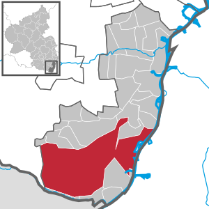
| Location of the city of Wörth am Rhein in the district of Germersheim | ||
  |
||

Wörth am Rhein is an association-free city with 18,120 inhabitants (as of December 31, 2019) in the district of Germersheim and in the southeast of Rhineland-Palatinate . It is located across from Karlsruhe on the left bank of the Rhine . The settlement of the Mercedes-Benz plant in Wörth , the largest truck assembly plant in the world, and a refinery in the 1960s meant that the population rose from around 3,500 in 1960 to 9,000 in the mid-1970s. Large residential areas and a new center on the Dorschberg emerged as a result of the industrial settlement. Since 1977 Wörth has been known as the “city”.
According to state planning, Wörth am Rhein is designated as a medium-sized center.
geography
location
The Bienwald , a large forest area, takes up most of the urban area . In the far north-west, the urban area extends right up to the cattle line . The district of Südliche Weinstrasse is already to the west of the city markings . Maximiliansau is located directly on the Rhine . Wörth is located on the eastern edge of the Bienwald . Büchelberg is located on a cleared island in the Bienwald, about ten kilometers west of Wörth. Schaidt is located on the northern edge of the Bienwald, about 15 kilometers west of Wörth.
Waters
.jpg)
In the east, the Rhine forms the city limits. The Wörther Old Rhine reaches right up to the city center. In the north, the Otterbach partially forms the boundary with Kandel. Its right tributary Bruchbach flows through Schaidt. The Schmerbach , Heilbach , Wiebelsbach and Heßbach , all of which run mainly in a west-east direction, run further south . The Heilbach also takes on the Saugraben from the right , into which the Aschbach flows and the Hessbach the Langen Graben .
climate
The annual precipitation is 752 mm. The precipitation is in the middle third of the values recorded in Germany. Lower values are registered at 52% of the measuring stations of the German Weather Service . The driest month is March, with the most rainfall in June. In June there is 1.6 times more rainfall than in March. The rainfall hardly varies and is evenly distributed over the year. Lower seasonal fluctuations are only registered at 15% of the measuring stations .
City structure
The city is divided into four districts (residents as of February 12, 2020):
| District | Residents (main and secondary residences) | Area km² |
|---|---|---|
| Büchelberg | 866 | 96.99 (of which 93.74 Bienwald) |
| Maximiliansau | 6,794 | 10.47 |
| Schaidt | 1,851 | 4.91 |
| Wörth | 9,141 | 19.26 |
| City of Wörth | 18,652 | 131.63 |
Neighboring communities
| Freckenfeld , Vollmersweiler | Neupotz , Kandel , Jockgrim , Minfeld , | Eggenstein-Leopoldshafen |
| Steinfeld |
.svg)
|
Karlsruhe |
| Scheibenhardt | Hagenbach , Berg (Palatinate) |
history
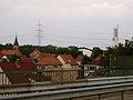
View over the old district

View into Ludwigstrasse, on the left the Church of St. Giles

Old town hall, now used as a gallery


The oldest document in which Wörth was mentioned comes from the year 1280. Settlers from the neighboring villages are likely to have settled in the meadow landscape and called the place "Werde" ("fenced in or others", alluding to its location on the water) Wise protected area "), later" Wörth ": island.
In 1628 the Wörther were forced by a flood disaster to give up their settlement and to settle in the desert of Forlach, to which they gave the name of their submerged place.
The places Wörth and Pfortz (later Maximiliansau) belonged to the Duchy of Pfalz-Zweibrücken and were subordinate to the office of Hagenbach . Büchelberg, Schaidt and the Bienwald, however, belonged to the Prince Diocese of Speyer , Lauterburg . At the end of the 17th century, sovereignty over parts of today's southern Palatinate, including Wörth with all of its current districts, passed to the Kingdom of France . With the French Revolution, the remaining sovereign rights of Zweibrücken expired, Wœrth-sur-le-Rhin - as it was called at the time - was fully incorporated into the Canton of Kandel . In 1815 Wörth came from France to Austria , in 1816 to Bavaria and in 1946 to Rhineland-Palatinate.
In 1864, Wörth received a train station on the Winden – Karlsruhe line , which was then opened between Winden and Maximiliansau. In 1876 the Schifferstadt-Wörth and Wörth-Strasbourg railway lines were opened.
The animal painter Heinrich von Zügel (1850–1941) trained artists from Germany and abroad in Wörth for decades . Wörth was therefore considered a "painter's village".
In 1960 Daimler AG bought space near Wörth and built a truck assembly plant there in the following years. In 1962, Mobil Oil bought land to build the Wörth refinery , which began production in 1970. In addition, the state built the Wörth state port, which was handed over in 1967.
Inspired by the industrial settlement, a new district ("Dorschberg") arose west of the old town of Wörth. In 1964 the land sold 30 hectares to the community in the Bienwald west of the Bienwaldsiedlung. In an urban planning competition, the concept of Albert Speer jr. through, which provided for a new city center there. In 1967 the land sold a further 32.5 hectares of Bienwald to the community, where mainly residential buildings were built until 1977. In 1967 the Dorschberg School was completed, which initially housed the grammar school until it moved into its own school building in 1970. In 1970/71 the town hall with underground car park, the indoor swimming pool, the public park and in 1973 the festival hall and the Catholic Church of St. Theodard were completed. Between 1974 and 1977 the Bienwaldhalle was built as a multi-purpose hall. In addition, two kindergartens were built.

Pedestrian zone in Dorschbergzentrum Wörth

Skyscrapers and water tower

High-rise buildings in Wörth

Bienwaldhalle with mural by Wolfgang Trust


With a deed dated May 14, 1977, the local community of Wörth am Rhein was elevated to a town. The then Prime Minister of Rhineland-Palatinate, Helmut Kohl, referred to Wörth in 1972 as the “calling card of the state of Rhineland-Palatinate” due to the rapid economic growth.
On June 30, 1996, Mobil-Oil closed the refinery. After the refinery had been dismantled and renovated by 2000, the city of Wörth bought the site back. From 2001 the Palm paper mill moved to the eastern part of the site. Other companies also settled here. Between 2005 and 2007, Daimler AG built a development and test center with a test track on Hafenstrasse, south of the former refinery.
Administrative and territorial reform

As part of the Rhineland-Palatinate functional and territorial reform that began in the second half of the 1960s, it came into force on April 22, 1972 on the basis of the “Thirteenth State Law on Administrative Simplification in the State of Rhineland-Palatinate” of March 1, 1972, the Verbandsgemeinde Wörth formed, to which the independent communities Büchelberg , Maximiliansau , Schaidt and Wörth belonged.
On June 8, 1979, the municipality of Büchelberg was incorporated into Wörth and on June 10, 1979 the Wörth community, the city of Wörth am Rhein and the local communities of Schaidt and Maximiliansau were dissolved and a community -free community was formed from these . At the same time, a part of the area with 60 inhabitants was reassigned from Wörth am Rhein to Scheibenhardt . Also on June 10, 1979, the new municipality of Wörth am Rhein was elevated to a city.
Population development
The industrial settlement in the 1960s meant that the population of Wörth rose from 3558 in 1961 to 7282 by 1970 and to 9144 in 1978.
In relation to the current territorial size, the population increased from 10,294 in 1963 by almost 72% to 17,698 in 1978, fell to 16,880 by 1986 and reached its highest level in 2001 with 17,732. In 2015 it was just below that with 17,645 inhabitants.
- Statistics on population development
The development of the population of Wörth am Rhein in relation to today's urban area; the values from 1871 to 1987 are based on censuses:
|
|
religion
Denomination statistics
According to the 2011 census , 25.4% of the population in 2011 were Protestant , 44.9% were mostly Roman Catholic and 29.6% were non-denominational , belonged to another religious community or did not provide any information. The number of Protestants and Catholics has fallen since then and with almost 42% people who do not belong to any religious community under public law are a relative majority of the population. Currently (as of March 31, 2020), 20.9% of the population are Protestant, 37.4% Roman Catholic and 41.7% are non-denominational or belong to another religious community.
Protestant churches
Maximiliansau
The so-called Protestant parish of Maximiliansau exists .
Wörth
The Protestant Christ Church is located in the middle of the old district. It was expanded from 1835 to 1836. In 1890 the wooden church tower was replaced by a stone tower.
The Protestant Church of Peace was built between 1981 and 1984 according to plans by the architect Peter Roth, head of the building department of the Prot. Landeskirche in Speyer. It is a two-story building with an octagonal church room on the upper floor, which can be expanded with two additional rooms. The community rooms are on the floor below. In the church there is art glazing by Johannes Schreiter , which was installed between 1986 and 2007. The municipality of Wörth supported the construction with 100,000 marks and made the land available.

Christ Church in Wörth

Peace Church in Wörth


Catholic churches
Since 2015, the parishes from Wörth, Hagenbach, Maximiliansau, Berg, Büchelberg and Neuburg have been forming a common parish under the name of St. Christophorus with the permanent place of worship in the Church of the Assumption of Mary in Maximiliansau. The Schaidt parish together with Kandel, Steinweiler and Minfeld form the parish of Hll. Fourteen emergency helpers with a permanent place of worship in Kandel.
Büchelberg
St. Laurentius Church
Maximiliansau
The Church of the Assumption of Mary was built in 1787, expanded in 1843 and expanded from 1936 to 1938.
Schaidt
St. Leo Church
Wörth

Church of St. Aegidius
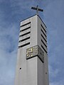
Tower of the Church of St. Aegidius

St. Theodard Church


The Catholic Church of St. Giles was built in 1961 according to plans by Erwin van Aaken . Before that, the old Catholic church, which was consecrated in 1837 and badly damaged in the Second World War, stood in the same place. It has a free-standing tower.
The Church of St. Theodard on Dorschberg was consecrated in 1973. The church, the youth home and the parsonage were built from 1970 according to plans by Alois Atzberger from the Speyer Episcopal Building Office. The municipality of Wörth supported the construction with 100,000 marks and made the land available.
Islam
The mosque named Wörth Ulu Camii (Wörth Ulu Mosque) was opened in 1993. The building on Bahnhofstrasse was bought in 1990 and converted into a mosque in 1992. It is supported by the Turkish-Islamic Community of Wörth eV , which is part of the DITIB umbrella organization . The first predecessor association was founded in 1976, prayer rooms were initially made available by the Wörth community and halls and churches were also used. The club moved to Maximiliansau at the end of the 1970s.
politics
In 1972 the municipalities of Büchelberg, Maximiliansau, Schaidt and Wörth formed the Verbandsgemeinde Wörth . The first mayor was the local mayor of Wörth, Karl-Josef Stöffler. In 1979 the Verbandsgemeinde became an association-free city, in which four local districts were established instead of the previously existing local communities. In federal elections, the city belongs to the constituency of Southern Palatinate . In state elections, Wörth initially belonged to the Germersheim constituency from 1991 ; Due to the strong population growth there in the following decades, the city will belong to the newly created constituency of Wörth am Rhein from 2021 .
City council
The city council in Wörth consists of 32 honorary council members, who were elected in the local elections on May 26, 2019 in a personalized proportional representation, and the full-time mayor Dennis Nitsche as chairman.
The distribution of seats in the city council:
| choice | SPD | CDU | FDP | GREEN | FWG | total |
|---|---|---|---|---|---|---|
| 2019 | 12 | 11 | 2 | 5 | 2 | 32 seats |
| 2014 | 14th | 14th | 1 | 3 | - | 32 seats |
| 2009 | 12 | 14th | 3 | 3 | - | 32 seats |
| 2004 | 10 | 17th | 2 | 3 | - | 32 seats |
City council election results from 1979 to 2019 (share of votes in percent):
| year | voter turnout | SPD | CDU | FDP | GREEN | FWG |
|---|---|---|---|---|---|---|
| 1979 | 76.9 | 34.0 | 53.7 | 5.3 | - | 7.0 |
| 1984 | 74.3 | 33.1 | 53.3 | 3.4 | 10.2 | - |
| 1989 | 76.1 | 37.3 | 41.9 | 4.2 | 9.1 | 7.5 |
| 1994 | 73.0 | 37.3 | 42.3 | 3.2 | 10.3 | 6.9 |
| 1999 | 63.8 | 38.2 | 49.6 | 2.6 | 5.6 | 3.9 |
| 2004 | 54.3 | 32.8 | 53.7 | 5.5 | 8.0 | - |
| 2009 | 49.7 | 37.6 | 44.4 | 8.3 | 9.7 | - |
| 2014 | 51.4 | 42.9 | 43.6 | 3.8 | 9.7 | - |
| 2019 | 58.2 | 37.4 | 34.8 | 6.3 | 14.9 | 6.9 |
mayor
- 1960–1980: Karl-Josef Stöffler (CDU)
- 1980–2016: Harald Seiter (CDU)
- since 2016: Dennis Nitsche (SPD)
In the direct election on March 13, 2016, Dennis Nitsche was elected with 54.8% of the vote. He began his eight-year term on July 1, 2016.
coat of arms
The blazon of the coat of arms reads: "In blue a fallen golden anchor with a looped black sign in the form of an S with a comma at the bottom left and a golden goose foot on the right and a golden beech tree on the left".
It was approved by the Neustadt district government in 1981 and shows the four main elements of the historical coats of arms of Wörth (anchor), Büchelberg (beech), Pfortz / Maximiliansau (S) and Schaidt (goose foot).
Town twinning
- Maximiliansau district: Cany-Barville ( France )
- Schaidt district: Geltendorf (Bavaria)
- City of Wörth am Rhein: Drezdenko ( Poland )
Culture and sights
Theaters and museums
- Gallery “Altes Rathaus”, where, in addition to the Heinrich von Zügel memorial exhibition, regular exhibitions by the Kunstverein Wörth eV take place
- Viehstrich-Museum (local history museum) in the Schaidt district
Buildings
- Church of St. Leo in Schaidt
- Sculpture garden 2000 in the Bürgerpark von Wörth, built between 1990 and 1999
- Europa-Brunnen at the Europa-Gymnasium, built in 1987
See also: List of cultural monuments in Wörth am Rhein
nature
Within the city limits there are a total of 15 natural monuments as well as the nature reserves Riedried and Bruchbach-Otterbachniederung . In terms of green spaces and local recreation, there is the Bürgerpark , the Promenadeweg , the Altrheinanlagen and the Cany-Barville-Anlage within Maximiliansau.
Sports
In Wörth there is the bathing park , a large swimming pool and a stadium. There is a sports center in Schaidt with a DFB football base.
Economy and Infrastructure
Companies
Daimler AG
The city's largest employer is the Mercedes-Benz plant in Wörth, the largest truck assembly plant in Europe. The Unimog , Econic , Zetros , Atego , Axor , Actros , Arocs and Antos types are manufactured. The plant has around 11,000 employees and is the second largest employer in Rhineland-Palatinate. In 1960, what was then Daimler-Benz AG bought the “Wörther Insel” on the Rhine from the municipality of Wörth and built a plant in which truck cabs were assembled with 100 employees from 1963. In the years that followed, the plant was expanded to become the largest truck assembly plant in Europe. The first truck rolled off the production line in 1965, and in 1967 Daimler-Benz moved truck assembly from Mannheim and Gaggenau to the Wörth plant. The factory premises are 2.4 million m², of which 480,000 m² are production space. The production capacity is up to 470 trucks per day. More than three million vehicles have been built since 1965. The most recent expansion of the site is a more than 50 hectare development and test center for commercial vehicles of Daimler AG , which went into operation in 2007, as well as the construction of the industrial park in several construction phases since 2000. The most recent expansion of the industrial park was completed at the end of 2010.
Palm paper mill

From 2001 the Palm paper mill with the world's largest paper machine was built on the site of the former Wörth refinery (closed in 1996) . It went into operation in 2002 and has a production capacity of 650,000 tons per year. Corrugated cardboard base papers are made from waste paper. In 2006, the Eurowell corrugated cardboard plant and the Europack packaging plant were built next to the paper mill, both of which belong to the Palm packaging group . The installation of the corrugated board system began in November 2006. The system went into operation at the end of February 2007. 250 million m² of corrugated cardboard formats are produced there every year. In addition, a combined cycle power plant was built on the factory premises.
Other companies on the former refinery site

Two freight forwarders, seat manufacturer SKA Sitz GmbH, a ThyssenKrupp plant , a distribution center of Netto Marken-Discount (in operation since 2009) also settled here.
Since the end of 2013, a beverage plant belonging to the Palatinate Refreshments, which is part of the Schwarz Group, has been in operation. Construction of the plant was approved in March 2012. The necessary groundwater is taken from a well about 1.5 kilometers southwest of the company premises. Six wells were built for this purpose. The investment was stated at more than 100 million euros. The plant covers an area of around 22 hectares, the buildings have a floor area of around 60,000 square meters and 1.2 million cubic meters of enclosed space. According to the works, around 150 jobs have been created. About half of it is made of mineral water and soft drinks such as cola or juice spritzers. Around 20 products are filled. The annual production is a little over a billion six-packs.
Other larger companies
The automotive supplier Faurecia produced plastic parts on the Daimler AG site in Wörth until 2014, for example dashboards for various car manufacturers. Webasto Mechatronics manufactures electronic components in Schaidt (previously production of car radios and navigation systems under the names Schaidt Innovations and Harman / Becker ). There are also several automotive suppliers and shipping companies as well as a larger metal processing company.
Trade associations
There are trade associations in the districts of Wörth, Maximiliansau and Schaidt.
media
The Rheinpfalz maintains an editorial branch in Wörth am Rhein.
As the Official Journal of the city are the Official Journal Wörth am Rhein out the weekly published since 1972 on Thursdays and free of charge to all households in the catchment area is distributed in an edition of 8000 copies. It contains all official announcements and official dates of the city of Wörth, but also editorial contributions to cultural events and information on the activities of the associations and the churches.
Public facilities
There is a police station in Wörth, whose service district includes the city of Wörth and the municipalities of Hagenbach, Jockgrim and Kandel.
In Wörth there is the festival hall with up to 886 seats and the Bienwaldhalle (multi-purpose hall). The Tullahalle culture hall is located in Maximiliansau, named after Johann Gottfried Tulla . The city belongs to the judicial district of the Kandel District Court .
education

In addition to kindergartens and elementary schools, there is a grammar school (Europa-Gymnasium), an integrated comprehensive school , named Carl Benz comprehensive school in 2020. Until 2015 there was a Realschule plus , a vocational school and a school for students with learning disabilities (Bienwaldschule).
Further training and further education institutions are the CJD Maximiliansau and the Institute for Educational Support in Wörth.
traffic
Street
At the Wörther Kreuz intersection , the federal highway 65 from Neustadt an der Weinstrasse and the federal roads 9 ( Kranenburg - Lauterbourg ) and 10 ( Lebach - Augsburg ) meet . At Maximiliansau there is a road bridge and the Rhine bridge Maximiliansau / Karlsruhe . The state road 540 runs in a north-south direction through the middle of the city and connects it with Neustadt an der Weinstrasse and Berg . The state road 546 leads through Schaidt and connects the place with Schweigen-Rechtenbach and Minfeld.
rail
tram
| Line S 5 , tram section in Wörth Stadtbahn Karlsruhe |
|||||||||||||||||||||||||||||||||||||||||||||||||||||||||||||
|---|---|---|---|---|---|---|---|---|---|---|---|---|---|---|---|---|---|---|---|---|---|---|---|---|---|---|---|---|---|---|---|---|---|---|---|---|---|---|---|---|---|---|---|---|---|---|---|---|---|---|---|---|---|---|---|---|---|---|---|---|---|
| Route number (DB) : | 9498 | ||||||||||||||||||||||||||||||||||||||||||||||||||||||||||||
| Course book section (DB) : | 710.5 | ||||||||||||||||||||||||||||||||||||||||||||||||||||||||||||
| Route length: | 2.7 km | ||||||||||||||||||||||||||||||||||||||||||||||||||||||||||||
| Gauge : | 1435 mm ( standard gauge ) | ||||||||||||||||||||||||||||||||||||||||||||||||||||||||||||
| Power system : | from km 0.6: 750 V = | ||||||||||||||||||||||||||||||||||||||||||||||||||||||||||||
| Power system : | Up to km 0.6: 15 kV 16.7 Hz ~ | ||||||||||||||||||||||||||||||||||||||||||||||||||||||||||||
| Minimum radius : | approx. 40 m | ||||||||||||||||||||||||||||||||||||||||||||||||||||||||||||
| Dual track : | to Bürgerpark | ||||||||||||||||||||||||||||||||||||||||||||||||||||||||||||
|
|||||||||||||||||||||||||||||||||||||||||||||||||||||||||||||
From the Wörth train station, a light rail line leads west through the Dorschberg development area . The Wörth Alte Bahnmeisterei , Wörth Bienwaldhalle , Wörth Bürgerpark , Wörth Rathaus , Wörth Badallee and Wörth Badepark stops are located here . The connection created as a tram was built between 1996 and 2003; the section between the train station and the provisional Rathaus stop in front of the Europa-Gymnasium was opened on September 27, 1997, the section from the town hall to the bathing park on June 14, 2003. By the time the second section of the route went into operation, the first was electrified with 15 kV AC voltage.

The route is served by the Albtal-Verkehrs-Gesellschaft's S5 light rail line , which runs from Wörth Badepark via the city center through Wörth to Wörth station and from there on the Winden – Karlsruhe line in the direction of Maximiliansau. At Knielingen it changes over a connecting route to the Karlsruhe tram network .
railroad

The railway lines Schifferstadt – Wörth , Wörth – Strasbourg and Winden – Karlsruhe meet at Wörth (Rhine) station .
Another direct connection to Karlsruhe consists of the S5 line from the city center with the S51 and S52 light rail lines, which run between Germersheim and Karlsruhe city center via the Wörth train station. The Wörth Zügelstraße stop between Abtswaldstraße and Heinrich-Schütz-Straße was opened for the S51 and S52 in December 2011 .
The Wörth Mozartstraße stop is on the Winden-Karlsruhe railway line and has been in operation since March 2009. Maximiliansau has the Maximiliansau Eisenbahnstraße and Maximiliansau West stops on this line . In the course of the reactivation of the German part of the line to Strasbourg in 2002, the place in the west received Maximiliansau Im Rüsten, a newly created stop for regional trains that run every hour to Lauterbourg .
The Schaidt stop is on the Neustadt – Wissembourg railway line (Maximiliansbahn). It was built in 1997 near the center of the village on Vollmersweilerer Strasse. The district Bahnhof Schaidt , where the former train station was located, is already on the outskirts of the Steinfeld community .
In 1964 an industrial trunk line was built between the Wörth train station and the state port . There are siding of Daimler AG, the paper mill Palm and the port.
water
At the port Wörth are handling facilities for containers, for cars and for paper. The port area is 186 hectares. There are three container loading bridges, the storage area is 153,000 m². A freight transport center was also opened in 2004 . The port of Wörth is one of the most important and efficient container terminals on the Upper Rhine, in 2014 143,378 TEU were handled.
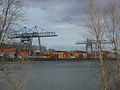
Wörth harbor

Cranes for handling containers at the Wörth port


tourism
Wörth is the eastern end point of the Petronella Rhine Cycle Route and two hiking trails; one begins in Saarbrücken is marked with a green bar and belongs to the Saar-Rhein hiking trails. Another is marked with a white and blue bar and begins in Battenberg . The path, which is also one of the so-called Saar-Rhein hiking trails and marked Schwarzer Punkt on a white bar , also runs through Wörth and leads from Saarbrücken to Rülzheim.
Personalities
Honorary citizen
- Max Bergmann (1884–1955)
- Hans Mohr, head of the Rhineland-Palatinate port operations, granted honorary citizenship in May 1969
- Karl-Josef Stöffler (1915–1995), mayor from 1960 to 1980, honorary citizenship granted in April 1980
- Heinrich von Zügel (1850–1941), painter
sons and daughters of the town
- Valentin Schwende (15th century), author of a medical-pharmaceutical textbook
- Ferdinand Brossart (1849–1930), 1915–1923 Bishop of the Diocese of Covington, Kentucky, USA.
- Martin Walzer (1883–1958), priest, prelate
- Paul Wever (1893–1944), naval officer, most recently Vice Admiral in the Navy in World War II
- Willibald Gänger (1903–1994), politician (SPD), member of the state parliament
- Emil Geörger (1912–1967), politician (CDU)
- Ludwig Damminger (1912–1981), football player
- Klaus Blumentritt (* 1941), administrative lawyer
Connected with Wörth
- Kevin Akpoguma (* 1995), German soccer player, played for FC Bavaria Wörth in his youth
- Friedel Grützmacher (* 1942), former member of the state parliament ( Bündnis 90 / Die Grünen ), lived in Wörth
- Tobias Lindner (* 1982), member of the Bundestag (Bündnis 90 / Die Grünen), lives in Wörth
- Arthur Nísio (1906–1974), Brazilian painter, lived in Wörth until 1944, a street is named after him
- Katrin Rehak-Nitsche (* 1978), member of the state parliament (SPD)
- Ludwig Siffling (1921–2020), soccer player at SV Waldhof Mannheim , lived in Wörth and is buried there
- Amelie Solja (* 1990), table tennis player
- Petrissa Solja (* 1994), table tennis player
- Herbert Wetterauer (* 1957), artist and author, lives in Wörth
- Marlene Zapf (* 1990), grew up in Wörth and plays in the handball Bundesliga for TuS Metzingen
literature
- Manfred Bader, Albert Ritter and Albert Schwarz: Wörth am Rhein. Local history . Two volumes. City of Wörth am Rhein and Manfred Bader, Wörth am Rhein 1983, together 1831 p.
- Norbert Bartsch and Ernst Röhrig: The city forest of Wörth on the Rhine. Forest history, current condition, vegetation units and stand types, information on forest treatment . Notices from the State Forestry Administration of Rhineland-Palatinate, No. 11. Ministry of Agriculture, Viticulture and Forests, Mainz 1993
Web links
- Website of the city of Wörth
- Website of the Festhalle Wörth
- Website of the Wörth trade association
- Website of the trade and industrial association Schaidt eV
- Literature about Wörth am Rhein in the Rhineland-Palatinate state bibliography
Individual evidence
- ↑ a b State Statistical Office of Rhineland-Palatinate - population status 2019, districts, municipalities, association communities ( help on this ).
- ↑ a b State Statistical Office Rhineland-Palatinate - regional data
- ↑ Numbers, data, facts - www.woerth.de
- ↑ a b City history of Wörth am Rhein ( Memento from January 6, 2010 in the Internet Archive )
- ↑ a b c Official Journal Wörth am Rhein: Special supplement paper mill Palm ( Memento from March 31, 2016 in the Internet Archive ) (PDF; 17.0 MB), April 2, 2006
- ↑ a b c d e f g h Official Journal of the City of Wörth am Rhein: Special supplement “50 Years Contract between Daimler-Benz AG and the Wörth Municipality” , November 25, 2010, written by Albert Ritter, accessed on January 21, 2014.
- ↑ Official municipality directory (= State Statistical Office of Rhineland-Palatinate [Hrsg.]: Statistical volumes . Volume 407 ). Bad Ems February 2016, p. 183 (PDF; 2.8 MB).
- ↑ Official municipality directory (= State Statistical Office of Rhineland-Palatinate [Hrsg.]: Statistical volumes . Volume 407 ). Bad Ems February 2016, p. 188 (PDF; 2.8 MB).
- ↑ official population , cf. Statistical yearbook of the city of Karlsruhe 1978, p. 109, quoted. n. Manfred Bader, Albert Ritter and Albert Schwarz: Wörth am Rhein. Local history. 1983, p. 1626
- ↑ Regional data from the Rhineland-Palatinate State Statistical Office, population development 1963 to 2015 , number based on the sole or main residence. Results of the population extrapolation based on the 1987 and 2011 census. Accessed on October 24, 2016.
- ↑ 2011 census, city of Wörth am Rhein, population in regional comparison by religion -in% -. In: results.zensus2011.de. Federal and State Statistical Offices, 2014, accessed on May 2, 2020 .
- ^ Municipal statistics , association-free municipality Wörth am Rhein, city. (PDF; 11.3 KB) April 1, 2020, accessed on May 2, 2020 .
- ^ Manfred Bader, Albert Ritter and Albert Schwarz: Wörth am Rhein. Local history. 1983, p. 1199
- ↑ Förderverein Farbfenster Friedenskirche Wörth on the website of the Prot. Friedenskirchengemeinde Wörth, accessed on March 5, 2014.
- ↑ a b Church of St. Theodard ( Memento of May 7, 2013 in the Internet Archive ) on the pages of the parishes of St. Giles and St. Theodard, accessed on March 5, 2014.
- ^ Diocese of Speyer ( Memento of March 14, 2016 in the Internet Archive ), parish structure of the Diocese of Speyer 2015, accessed on April 7, 2014.
- ^ Diocese of Speyer ( memento of March 14, 2016 in the Internet Archive ), The names of the new parishes, accessed on April 7, 2014.
- ↑ Homepage of the parish of Maria Himmelfahrt , accessed on April 7, 2014.
- ↑ The cath. Church of the parish of St. Agidius ( memento of February 2, 2014 in the Internet Archive ) on the pages of the parishes of St. Agidius and St. Theodard, accessed on March 5, 2014.
- ↑ Turkish-Islamic Community of Wörth e. V. ( Memento of February 23, 2014 in the Internet Archive ), accessed on March 5, 2014.
- ^ The Regional Returning Officer RLP: Municipal elections 2019 Wörth am Rhein. Retrieved August 15, 2019 .
- ↑ Local election Rhineland-Palatinate 2014, City Council
- ↑ a b Local election Rhineland-Palatinate 2009, City Council
- ↑ State Statistical Office Rhineland-Palatinate: City Council election results from 1969 to 2009
- ^ The Rhine Palatinate: Wörth: Dennis Nitsche (SPD) elected mayor. March 13, 2016, accessed December 7, 2019 .
- ^ Karl Heinz Debus: The great book of arms of the Palatinate . Neustadt an der Weinstrasse 1988, ISBN 3-9801574-2-3
- ↑ Archive link ( Memento from December 22, 2015 in the Internet Archive )
- ↑ Archive link ( Memento from December 22, 2015 in the Internet Archive )
- ↑ Daimler AG: Das Werk Wörth: Data & Facts ( Memento from December 28, 2011 in the Internet Archive ), accessed on June 14, 2012.
- ↑ a b c Wörth plant on the Mercedes-Benz Lkw website ( memento from August 6, 2013 in the Internet Archive ), accessed on September 7, 2013.
- ^ History of the Wörth plant on the website of Daimler AG ( Memento of October 12, 2007 in the Internet Archive ), accessed on September 7, 2013.
- ^ Werk Wörth on the pages of the Palm paper mill ( Memento from April 21, 2014 in the Internet Archive ), accessed on April 20, 2014.
- ↑ sides of Euro Well , accessed October 25, 2014.
- ↑ sides of Euro Pack , accessed October 25, 2014.
- ↑ Wörth branch on the website of Netto ( Memento from July 14, 2014 in the Internet Archive ), accessed on June 8, 2014.
- ↑ a b c Dieter Wiebelt: "'Saskia' springs from the Rhine", in: Die Rheinpfalz , Pfälzer Tageblatt, edition Rheinschiene , page Wirtschaft regional, 14 May 2014.
- ↑ Archive link ( Memento from December 24, 2013 in the Internet Archive ) Press release from the Structural and Approval Directorate South
- ^ Official Journal Wörth am Rhein: It will soon be bubbling at the Wörther Hafen ( memento from March 6, 2016 in the Internet Archive ), September 2, 2010 (PDF; 5.5 MB), accessed on September 7, 2013.
- ↑ https://www.webasto-group.com/de/presse-events/pressemitteilungen/news-article/webasto-uebernehmen-elektronik-dienstleistungs-schaidt-innovations/?no_cache=1
- ^ Official Journal Wörth am Rhein ( Memento from January 7, 2010 in the Internet Archive )
- ↑ Police Inspection Wörth am Rhein ( memento from January 6, 2013 in the Internet Archive ) on the website of the Rhineland-Palatinate State Police
- ^ Page of the Integrated Comprehensive School Wörth , accessed on February 25, 2020.
- ↑ History of Realschule plus , accessed on September 7, 2013. Realschule plus will expire from the 2010/11 school year to the 2014/15 school year, with the integrated comprehensive school being set up in parallel.
- ^ Klaus Bindewald: The Albtal traffic company. Exemplary local transport system worldwide . 2007, p. 100 .
- ^ Port of Wörth der Häfen RLP ( Memento from June 17, 2013 in the Internet Archive ), accessed on June 17, 2012.
- ↑ Archived copy ( memento of March 4, 2016 in the Internet Archive ) data on the port
- ↑ Susanne Nägele: Valentin Schwendes 'book of menicherhande gendered kornnes and menicherley fruitte': the 'Liber de diaetis particularibus' ('Kitāb al-Aġḏiya') of Isaak Judäus in an Upper Swabian translation of the 15th century. Introduction and critical text output. Würzburg 2001 (= Würzburg medical historical research. Volume 76).

Bellheim | Berg (Palatinate) | Erlenbach near Kandel | Freckenfeld | Freisbach | Germersheim | Hagenbach | Hatzenbühl | Heard | Jockgrim | Candelabra | Knittelsheim | Kuhardt | Leimersheim | Lingenfeld | Lustadt | Minfeld | Neuburg am Rhein | Neupotz | Ottersheim near Landau | Rheinzabern | Rülzheim | Scheibenhardt | Schwegenheim | Steinweiler | Vollmersweiler | Weingarten (Palatinate) | Westheim (Palatinate) | Winches | Wörth am Rhein | Zeiskam