
Vollmersweiler
| coat of arms | Germany map | |
|---|---|---|

|
Coordinates: 49 ° 4 ' N , 8 ° 5' E |
|
| Basic data | ||
| State : | Rhineland-Palatinate | |
| County : | Germersheim | |
| Association municipality : | Candelabra | |
| Height : | 142 m above sea level NHN | |
| Area : | 2.18 km 2 | |
| Residents: | 198 (Dec. 31, 2019) | |
| Population density : | 91 inhabitants per km 2 | |
| Postal code : | 76744 | |
| Area code : | 06340 | |
| License plate : | GER | |
| Community key : | 07 3 34 031 | |
| LOCODE : | DE V2R | |
| Association administration address: | Gartenstrasse 8 76870 Kandel |
|
| Website : | ||
| Local Mayor : | Roland Kelemen | |
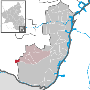
| Location of the local community Vollmersweiler in the district of Germersheim | ||
  |
||

Vollmersweiler is a municipality in the district of Germersheim in Rhineland-Palatinate . It has been a member of the Kandel community since 1972 .
Geographical location
The place is in the southern Palatinate between Karlsruhe and Landau in the Palatinate . Neighboring communities are - clockwise - Dierbach , Freckenfeld , Wörth am Rhein (district Schaidt ), Niederotterbach and Steinfeld .
history
Vollmersweiler belonged to Guttenberg until the end of the 18th century . At times in the 18th century it shared the mayor with the village of Niederotterbach to the west .
Population development
If not listed separately, the source of the data is the State Statistical Office of Rhineland-Palatinate.
|
|
|
religion
In 2012, 47.1 percent of the population were Protestant and 23.8 percent Catholic . The rest belonged to another religion or were non-denominational. In 1871, of a total of 227 residents, 173 were Protestant (76 percent) and 54 were Catholic (24 percent).
politics
Municipal council
The council in Vollmersweiler consists of six council members, who in the local elections on May 26, 2019 in a majority vote were elected, and the honorary mayor as chairman.
mayor
Roland Kelemen became the local mayor of Vollmersweiler on May 21, 2015. In the direct election on May 26, 2019, he was confirmed in his office for a further five years with a share of the vote of 69.63%. His predecessor Stefan Gärtner had to resign in January 2015 for health reasons. Before that, Sibylle Rauch-Toussaint (SPD) was Mayor of Vollmersweiler from 2009 to 2014 and Elvira Oberle (SPD) from 1991 to 2009.
coat of arms
The coat of arms description reads: "In red an inclined silver plow knife."
It was approved by the Bavarian State Ministry of the Interior in 1931 and goes back to a joint court seal of Vollmersweiler and Niederotterbach from 1581.
Culture and sights
Buildings

See: List of cultural monuments in Vollmersweiler
Regular events
In the first place is the annual Kerwe on the third Sunday in September, which lasts for three days. At the end of June / beginning of July the fountain festival takes place in the village square.
traffic
Vollmersweiler is connected to the local transport network via bus line 547, which connects the Kandel and Bad Bergzabern train stations . The Schaidt railway stop on the Winden-Weißenburg railway line is 800 m away.
Web links
- Local community Vollmersweiler on the website of the Verbandsgemeinde Kandel
- Literature about Vollmersweiler in the Rhineland-Palatinate state bibliography
Individual evidence
- ↑ State Statistical Office of Rhineland-Palatinate - population status 2019, districts, communities, association communities ( help on this ).
- ↑ State Statistical Office Rhineland-Palatinate: Vollmersweiler
- ↑ a b c Official directory and statistics of the Royal Bavarian Government District of the Palatinate, 1863, p. LX of the appendix
- ↑ a b Results of the census in the Kingdom of Bavaria from December 1, 1871 according to individual communities, 1873, p. 65
- ↑ KommWis, as of December 31, 2012
- ^ The Regional Returning Officer Rhineland-Palatinate: Local elections 2019, city and municipal council elections
- ^ The State Returning Officer Rhineland-Palatinate: direct elections 2019. see Kandel, Verbandsgemeinde, sixth result line. Retrieved April 26, 2020 .
- ^ Karl Heinz Debus: The great book of arms of the Palatinate . Neustadt an der Weinstrasse 1988, ISBN 3-9801574-2-3

Bellheim | Berg (Palatinate) | Erlenbach near Kandel | Freckenfeld | Freisbach | Germersheim | Hagenbach | Hatzenbühl | Heard | Jockgrim | Candelabra | Knittelsheim | Kuhardt | Leimersheim | Lingenfeld | Lustadt | Minfeld | Neuburg am Rhein | Neupotz | Ottersheim near Landau | Rheinzabern | Rülzheim | Scheibenhardt | Schwegenheim | Steinweiler | Vollmersweiler | Weingarten (Palatinate) | Westheim (Palatinate) | Winches | Wörth am Rhein | Zeiskam