
Knittelsheim
| coat of arms | Germany map | |
|---|---|---|

|
Coordinates: 49 ° 12 ' N , 8 ° 15' E |
|
| Basic data | ||
| State : | Rhineland-Palatinate | |
| County : | Germersheim | |
| Association municipality : | Bellheim | |
| Height : | 120 m above sea level NHN | |
| Area : | 6.37 km 2 | |
| Residents: | 1065 (Dec. 31, 2019) | |
| Population density : | 167 inhabitants per km 2 | |
| Postal code : | 76879 | |
| Area code : | 06348 | |
| License plate : | GER | |
| Community key : | 07 3 34 014 | |
| Association administration address: | Schubertstrasse 18 76756 Bellheim |
|
| Website : | ||
| Local Mayor : | Ulrich Christmann ( CDU ) | |
| Location of the local community Knittelsheim in the district of Germersheim | ||
  |
||

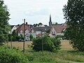
Knittelsheim

chapel

Spiegelbach


Knittelsheim is a municipality in the district of Germersheim in Rhineland-Palatinate . It belongs to the community of Bellheim .
geography
The place is between Germersheim and Landau in the Palatinate . The Knittelsheimermühle , Am Hochweg and Im Obersand residential areas also belong to Knittelsheim.
history
Finds from the Younger Stone Age, the Bronze Age and the Roman Ages prove that today's municipality was settled early. At Gollenberg, south of today's settlement, there was evidence of a larger settlement and a burial ground. In Roman times clay was extracted here. Another Roman burial ground was discovered near today's street Am Hochweg.
Knittelsheim was first mentioned in 808 in the " Weißenburger Codex Traditionum " as Cnutilesheim as a place in Speyergau . The ending -heim suggests that it was founded in the 5th to 6th centuries during the Franconian conquest . The first part of the place name is probably derived from the name Knutil - a diminutive of Knut.
The oldest written evidence of a church in Knittelsheim dates back to 1468. With interruptions, it was reserved for Protestants from 1556 to around 1680. In 1705 it finally fell to the Catholics according to the Electoral Palatinate Declaration of Religion. In the 1740s, the Protestants received a new church, which was demolished around 1827. In 1830/31 a new, still existing church was built elsewhere. The Catholic Church was torn down in 1832 "due to age and lack of space" except for the tower. The architect August von Voit was responsible for the current building (built 1833–1836).
Population development
If not listed separately, the source of the data is the State Statistical Office of Rhineland-Palatinate.
|
|
|
religion
In 1835 Knittelsheim had 667 inhabitants, of which 415 (62%) were Catholic and 252 (38%) were Protestant.
In 2012, 61.3 percent of the population were Catholic and 24.2 percent Protestant. The rest belonged to another religion or were non-denominational.
politics
Municipal council
The municipal council in Knittelsheim consists of 16 council members, who were elected in the local elections on May 26, 2019 in a personalized proportional representation, and the honorary local mayor as chairman.
The distribution of seats in the municipal council:
| choice | SPD | CDU | FWG | Zik | total |
|---|---|---|---|---|---|
| 2019 | 1 | 7th | 5 | 3 | 16 seats |
| 2014 | 1 | 7th | 5 | 3 | 16 seats |
| 2009 | 1 | 7th | 5 | 3 | 16 seats |
| 2004 | 1 | 7th | 3 | 1 | 12 seats |
- FWG = Free Voters Group Knittelsheim e. V.
- Zik = Voting Group Future in Knittelsheim e. V.
mayor
|
|
Ulrich Christmann was confirmed in his office for another five years in the direct election on May 26, 2019 with a share of 62.99% of the votes.
coat of arms
| Banner, coat of arms and flag | |

|
|

|
|
|
Blazon : "In silver three green reeds with brown reeds rising from the base of the shield, the middle of which is exaggerated by the two outer ones, obliquely to the right and left, covered with a blue horseshoe with downward sloping studs, into which the central reed grows."
It was approved on December 14, 1950 by the Mainz Ministry of the Interior and goes back to a seal from 1730. An application for approval submitted in 1939 was not implemented due to the war. |
|

Partner communities
Knittelsheim has had a partnership with the Hungarian municipality of Bősárkány since 2006 .
Culture and sights
Knittelsheim mill
The Knittelsheimer Mühle am Spiegelbach ( Lage ) was built in the second half of the 17th century. From 1768 to 1898 it was owned by the Disqué family, who owned a total of 12 mills in the Queich catchment area . A few years after the Disqué family sold the mill, it lost its original function. Today the property functions as a restaurant and country hotel.
Regular events
- Knittelsheimer Kerwe (parish fair), annually on the first weekend in October, every two years the coronation of the "Knillsemer Kätzel"
- Flammkuchen Festival (since 1996), annually on the day before Midsummer , with a Midsummer bonfire
traffic
The federal highway 9 , which leads from Karlsruhe to Speyer , runs east of the municipality . Knittelsheim is connected to the larger towns in the area by two bus routes.
Honorary citizen
- Eduard Antoni (1914–1995), pastor in Knittelsheim
- Kurt Starck (* 1941), Mayor of Knittelsheim
See also
literature
- Knittelsheim community (ed.): 1200 years of Knittelsheim. Knittelsheim 2008, ISBN 978-3-00-024787-3 .
Web links
- Local community Knittelsheim
- In this country: Kirchstrasse in Knittelsheim. State show Rhineland-Palatinate, SWR television, July 10, 2014
- Literature about Knittelsheim in the Rhineland-Palatinate State Bibliography
Individual evidence
- ↑ a b State Statistical Office of Rhineland-Palatinate - population status 2019, districts, municipalities, association communities ( help on this ).
- ↑ State Statistical Office Rhineland-Palatinate (ed.): Official directory of the municipalities and parts of the municipality. Status: January 2019 [ Version 2020 is available. ] . S. 146 (PDF; 3 MB).
- ↑ 1200 years of Knittelsheim. P. 25 ff.
- ↑ suedpfalz-tourismus-vg-bellheim.de: Knittelsheim.
- ↑ 1200 years of Knittelsheim. P. 11 ff.
- ↑ 1200 years of Knittelsheim. P. 71 ff.
- ↑ State Statistical Office Rhineland-Palatinate: My village, my city. Retrieved February 25, 2020 .
- ↑ 1200 years of Knittelsheim. P. 299 → Michael Frey: Attempt at a geographical-historical-statistical description of the royal Bavarian Rhine district. Volume 1, 1836, p. 573. Explicit reference to incorrect indication of 344 instead of 444 inhabitants, as recorded, for example, in the work Directory of Officials and Statistics of the Royal Bavarian Government District of the Palatinate , 1863, on p. XXI of the appendix.
- ↑ a b Directory of officials and statistics of the Royal Bavarian Government District of the Palatinate. 1863, p. XXI of the appendix.
- ^ Results of the census in the Kingdom of Bavaria from December 1, 1871 by individual communities. 1873, p. 64.
- ↑ Ewois. As of December 31, 2012
- ^ The Regional Returning Officer Rhineland-Palatinate: Local elections 2019, city and municipal council elections.
- ↑ a b 1200 years of Knittelsheim. P. 273 f.
- ^ The Regional Returning Officer of Rhineland-Palatinate: direct elections 2019. see Bellheim, Verbandsgemeinde, second line of results. Retrieved April 25, 2020 .
- ^ Karl Heinz Debus: The great book of arms of the Palatinate. Gräber, Neustadt an der Weinstrasse 1988, ISBN 3-9801574-2-3 , p. 100.
- ↑
- ↑ partner community. Verbandsgemeinde Bellheim, accessed on February 25, 2020 : "Since October 2006, Knittelsheim has had a partnership with the Hungarian municipality of Bösárkánay."
- ↑ Carl Heupel, Peter Sinn: Die Knittelsheimer Mühle , in: 1200 Jahre Knittelsheim , p. 133 ff.
- ↑ Website Waldhaus Knittelsheimer Mühle

Bellheim | Berg (Palatinate) | Erlenbach near Kandel | Freckenfeld | Freisbach | Germersheim | Hagenbach | Hatzenbühl | Heard | Jockgrim | Candelabra | Knittelsheim | Kuhardt | Leimersheim | Lingenfeld | Lustadt | Minfeld | Neuburg am Rhein | Neupotz | Ottersheim near Landau | Rheinzabern | Rülzheim | Scheibenhardt | Schwegenheim | Steinweiler | Vollmersweiler | Weingarten (Palatinate) | Westheim (Palatinate) | Winches | Wörth am Rhein | Zeiskam