
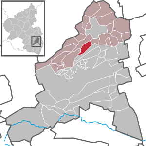
Battenberg (Palatinate)
| coat of arms | Germany map | |
|---|---|---|

|
Coordinates: 49 ° 32 ' N , 8 ° 8' E |
|
| Basic data | ||
| State : | Rhineland-Palatinate | |
| County : | Bad Dürkheim | |
| Association municipality : | Leiningerland | |
| Height : | 300 m above sea level NHN | |
| Area : | 5.45 km 2 | |
| Residents: | 395 (Dec. 31, 2019) | |
| Population density : | 72 inhabitants per km 2 | |
| Postal code : | 67271 | |
| Area code : | 06359 | |
| License plate : | DÜW | |
| Community key : | 07 3 32 003 | |
| Association administration address: | Industriestrasse 11 67269 Grünstadt |
|
| Website : | ||
| Local Mayor : | Hans-Peter Schmidt (independent) | |
| Location of the local community Battenberg (Pfalz) in the Bad Dürkheim district | ||
 _in_D%C3%9CW.svg) |
||


Battenberg (Pfalz) is the smallest municipality in terms of population in the Rhineland-Palatinate district of Bad Dürkheim . It is located 20 km west of Ludwigshafen am Rhein directly on the western fracture zone of the Rhine rift valley and belongs to the community of Leiningerland .
Geography and geology
Location and surroundings
Battenberg is located in the northwest of the European metropolitan region Rhine-Neckar and on the western edge of the Upper Rhine Plain . Geologically, this is the interface between the low mountain range of the Palatinate Forest and the deep rift valley of the Rhine Valley. The neighboring communities are - clockwise - Neuleiningen , Kleinkarlbach , Bobenheim am Berg and Altleiningen .
Battenberg sits on the Leininger Sporn , the northeastern foothills of the Palatinate Forest, from where the altitude drops to the northwest to the Eisenberg basin . On the eastern slope of the spur runs the fault line where the former floor of today's Upper Rhine Rift valley sank over 10 km and was filled with younger sediments to the present level.
The edge of the mountain consists largely of red sandstone , which was created here from blown desert sand 250 million years ago . The so-called Kapuzinerstein also occurs on site. The Haardtrand nature reserve - Im Baumgarten is partly on the parish of the local community.
Waters and elevations
At 300 m above sea level NHN , about 150 m above the right bank of the Eckbach , the small village is grouped west of the castle of the same name , without the watercourse itself touching the parish of the local community. Through the southeast of the municipal territory, but away from the settlement area, which runs Krumbach , which was named after him Krumbachtal south traverses the building.
The Harzweilerkopf ( 415 m ) and the Pickelhaube ( 361 m ) are striking elevations in the parish of the municipality .
history
Antiquity and the Middle Ages
There is an old Paleolithic site with anvil stones, rubble tools, heavy house stones, cleavers and massive scrapers, from which the Acheuléen is partly covered with desert varnish . The room was free of glaciers during the Ice Age. The quartzite artifacts found by Kurt E. Kocher , in which he recognizes facial profiles, idols or animal sculptures that he assigns to Homo erectus and the Neanderthals , are very controversial (see Old Paleolithic Cabaret ) . Most are over 120,000 years old. A similar find, dated 230,000 years ago, came from the Golan Heights.
The Lorraine Abbey of Glandern , which was wealthy in Grünstadt and Mertesheim , exercised the right of patronage for the still-preserved Martinskirche early on , which in 1231 passed to the Worms Cathedral Chapter . The often mentioned first mention of the Glanderer property in Battenberg in 836 is based on a forged document. Even after 1231, Glandern still seems to have had rights to the church, because in 1324 the abbot there gave his consent to the 1315 foundation of a measurement pledge on a newly built altar in the Battenberg church.
Battenberg Castle , owned by the noble family of Leininger since the Middle Ages , to which the Leiningerland belonged at that time , controlled the entrance to the Eckbachtal together with Neuleiningen Castle , located to the north (1,400 m as the crow flies) .
Modern times
Until the end of the 18th century, the place belonged to Leiningen-Dagsburg . From 1798 to 1814, when the Palatinate was part of the French Republic (until 1804) and then part of the Napoleonic Empire , Battenberg was incorporated into the canton of Grünstadt and was subordinate to Mairie Bobenheim . In 1815 the place Austria was added.
From 1816 on, the Protestant parish village of Battenberg belonged to the Kingdom of Bavaria and was still part of the now Bavarian canton of Grünstadt in the Rhine district . From 1818 to 1862 he was a member of the Frankenthal Land Commissioner ; from this the district office of Frankenthal emerged. In 1840 the place had 45 houses and 269 inhabitants, including 48 Mennonites .
From 1939 Battenberg was part of the Frankenthal (Palatinate) district . After the Second World War , the place became part of the then newly formed state of Rhineland-Palatinate within the French occupation zone . On September 7, 1966, the community received the addition of "Pfalz" to its name to distinguish it from Battenberg (Eder) . In the course of the first Rhineland-Palatinate administrative reform , the place moved to the newly created district of Bad Dürkheim . Three years later, it became part of the newly created community of Grünstadt-Land , before it was merged into the community of Leiningerland in 2018 .
Population development
The development of the population of Battenberg; the values from 1871 to 1987 are based on censuses.
|
|
politics
Municipal council
The local council in Battenberg consists of eight council members, who were elected in a majority vote, and the honorary local mayor as chairman.
In the local elections on May 26, 2019, Peter Schmidt was elected local mayor with 60.5 percent.
coat of arms
The Battenberg coat of arms is based on the connection between the Counts of Leiningen and the Benedictine abbey of Murbach in Upper Alsace . It is divided and shows the silver Leininger Adler in blue at the top and the jumping Black Dog von Murbach in white at the bottom .
Sights and culture
Buildings and nature

The main sights are the aforementioned Battenberg Castle and the Gothic village church of St. Martin (around 1200), which also contains older - Romanesque - components. To the west of the community, in the Palatinate Forest , is the baroque hunter's cross in memory of a homicide in 1702. The Kleinkarlbach transmitter is located in the north of the community, not far from the boundary with Kleinkarlbach . The lightning tubes on the driveway to the site are the only on-site property classified as a natural monument .
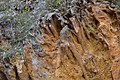
Flash tubes

Stair tower of Battenberg Castle
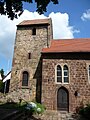
Prot. Martinskirche

Romanesque door on the church with tympanum

Hunter's Cross, 1702


Events
Every year at the beginning of April, the Stabaus takes place on a Sunday .
Economy and Infrastructure
economy
-_Hauptstra%C3%9Fe-_Richtung_S%C3%BCdwest_(Altleiningen)_26.4.2008.jpg)
Battenberg is a residential community in which viticulture is also practiced. As such, it belongs to the Palatinate wine-growing region . The Schloßberg single site is located on site ; the local vineyards are concentrated in the area to the north and east of the development.
traffic
Because of the geographic location, there is no through traffic in Battenberg. The community is connected to the road network via Kreisstraße 30, which leads to Kleinkarlbach. The federal autobahn 6 , which connects Saarbrücken and Mannheim , passes Battenberg 1 km north, but the next connection at Grünstadt is 5 km away.
From 1903 the Neuleiningen-Kleinkarlbach station was the closest train station to the Grünstadt – Altleiningen railway line that opened that year , before passenger traffic there was discontinued in 1967. Since then, the next train station in Kirchheim an der Pfälzische Nordbahn Neustadt an der Weinstrasse - Monsheim is 4 km.
Battenberg is located on the Palatinate Weinsteig , which is of tourist importance for hikers and cyclists.
Personalities
- Karl Ludwig von Leiningen-Dagsburg-Emichsburg (1704–1747), count and sovereign, temporarily resided in Battenberg, where he also died and was buried in the Martinskirche.
- Johann Höpffender , 1792/93 member of the Rhine-German National Convention
- Rosmarien Weber-Markert (1927–2010), painter, had an on-site studio from 1975.
- Dieter Spiess (1924–2017), entrepreneur and honorary consul, died on site.
literature
- Literature about Battenberg in the Rhineland-Palatinate State Bibliography
Web links
- Private website about Battenberg
- Local community Battenberg on the website of the Verbandsgemeinde Grünstadt-Land
Individual evidence
- ↑ a b State Statistical Office of Rhineland-Palatinate - population status 2019, districts, municipalities, association communities ( help on this ).
- ^ Emil Hoffmann: Lexicon of the Stone Age. CH Beck Verlag, Munich 1999, ISBN 3-406-42125-3 , p. 38.
- ^ Website about the Battenberg Church.
- ^ Regest of the forged document from 836 ( Memento of January 4, 2014 in the Internet Archive ).
- ↑ Regest with a picture of the certificate
- ^ Max Siebert: The Kingdom of Bavaria topographically and statistically in lexicographical and tabular form , Verlag Georg Franz, Munich 1840. P. 157 ( Google Books ).
- ↑ Official municipality directory 2006 ( Memento from December 22, 2017 in the Internet Archive ) (= State Statistical Office Rhineland-Palatinate [Hrsg.]: Statistical volumes . Volume 393 ). Bad Ems March 2006, p. 203 (PDF; 2.6 MB). Info: An up-to-date directory ( 2016 ) is available, but in the section "Territorial changes - Territorial administrative reform" it does not give any population figures.
- ↑ State Statistical Office Rhineland-Palatinate - regional data
- ↑ Regional Returning Officer Rhineland-Palatinate: Municipal elections 2019. Accessed on September 17, 2019 .
- ↑ Mayor of Battenberg 2019. Accessed on September 17, 2019 .

Altleiningen | Bad Dürkheim | Battenberg (Palatinate) | Bissersheim | Bobenheim am Berg | Bockenheim an der Weinstrasse | Carlsberg | Dackenheim | Deidesheim | Dirmstein | Ebertsheim | Ellerstadt | Elmstein | Erpolzheim | Esthal | Forest on the Wine Route | Frankeneck | Freinsheim | Friedelsheim | Gerolsheim | Gönnheim | Grosskarlbach | Grünstadt | Hassloch | Herxheim am Berg | Hettenleidelheim | Kallstadt | Children's home | Kirchheim an der Weinstrasse | Kleinkarlbach | Lambrecht (Palatinate) | Laumersheim | Lindenberg | Meckenheim | Mertesheim | Neidenfels | Neuleiningen | Niederkirchen near Deidesheim | Obersülzen | Obrigheim (Palatinate) | Quirnheim | Ruppertsberg | Tiefenthal | Wachenheim an der Weinstrasse | Wattenheim | Weidenthal | Weisenheim am Berg | Weisenheim am Sand