Frankeneck
| coat of arms | Germany map | |
|---|---|---|

|
Coordinates: 49 ° 23 ' N , 8 ° 3' E |
|
| Basic data | ||
| State : | Rhineland-Palatinate | |
| County : | Bad Dürkheim | |
| Association municipality : | Lambrecht (Palatinate) | |
| Height : | 173 m above sea level NHN | |
| Area : | 4.76 km 2 | |
| Residents: | 816 (Dec. 31, 2019) | |
| Population density : | 171 inhabitants per km 2 | |
| Postal code : | 67468 | |
| Area code : | 06325 | |
| License plate : | DÜW | |
| Community key : | 07 3 32 018 | |
| LOCODE : | DE FRK | |
| Association administration address: | Sommerbergstrasse 3 67466 Lambrecht (Palatinate) |
|
| Website : | ||
| Local Mayor : | Marco Fränzel ( SPD ) | |
| Location of the local community Frankeneck in the Bad Dürkheim district | ||
Frankeneck is a municipality in the Bad Dürkheim district in Rhineland-Palatinate . It belongs to the Verbandsgemeinde Lambrecht (Palatinate) , within which it is the second smallest local community in terms of population.
geography
location
The community is located in the Middle Palatinate Forest in the Elmstein Valley . Neidenfels , Deidesheim , Lambrecht , Esthal and Weidenthal are neighboring communities - clockwise .
Elevations and waters
Frankeneck itself is located at the confluence of the Speyerbach and Hochspeyerbach rivers . In the southwest, the Esthalbach forms the boundary to Esthal. The Zigeunerkopf extends northwest of the settlement area, the Kleine Pflasterberg in the district triangle with Neidenfels and Weidenthal and the 506 meter high Mollenkopf in the district triangle with Esthal and Weidenthal .
history
The parish was founded in 1785. At first it belonged to Leiningen-Dagsburg . From 1798 to 1814, when the Palatinate was part of the French Republic (until 1804) and then part of the Napoleonic Empire , Neufrankeneck - as it was then called - was incorporated into the canton of Neustadt (Donnersberg) and was subordinate to the Mairie Esthal . In 1815 it was added to Austria . Just one year later, the place, like the entire Palatinate, changed to the Kingdom of Bavaria . From 1818 to 1862 the community belonged to the Landkommissariat Neustadt ; from this the district office of Neustadt emerged.
From 1939 Frankeneck was part of the Neustadt district . After the Second World War , the place became part of the then newly formed state of Rhineland-Palatinate within the French occupation zone . In the course of the first Rhineland-Palatinate administrative reform , the place moved in 1969 to the newly created district of Bad Dürkheim . Three years later, Frankeneck became part of the also newly created Verbandsgemeinde Lambrecht (Palatinate) .
Religions
In 2013, 41.0 percent of the population were Protestant and 29.6 percent Catholic . The rest belonged to another religion or were non-denominational .
politics
Municipal council
The municipal council in Frankeneck consists of twelve council members , who were elected in a personalized proportional representation in the local elections on May 26, 2019 , and the honorary local mayor as chairman.
The distribution of seats in the municipal council:
| choice | SPD | CDU | total |
|---|---|---|---|
| 2019 | 8th | 4th | 12 seats |
| 2014 | 8th | 4th | 12 seats |
| 2009 | 8th | 4th | 12 seats |
| 2004 | 8th | 4th | 12 seats |
mayor
The local mayor is Marco Fränzel (SPD). In the direct election on May 26, 2019, he was elected with 63.64 percent of the vote and is the successor to Jürgen Schlupp (SPD), who no longer took up this office.
coat of arms
| Blazon : "Through a blue shaft, above right in red a floating blue ax with a golden handle, above left in red a floating blue forest sickle hook with golden handle, below in silver a blue-frosted red vat with silver contents, in front of it a red stirring sieve." | |
| Reasons for the coat of arms: It was approved by the Mainz Interior Ministry in 1951 . The figures remind of the foundation of the community as a woodcutter village. |
Community partnerships
With Tenbury Wells in Worcestershire , United Kingdom and Le Thuit de l'Oison ( Le Thuit-Anger , Le Thuit-Signol , Le Thuit-Simer ) in France are partnerships maintained.
Culture and sights
Cultural monuments
There are a total of six objects on site that are under monument protection , including the papermaking and local history museum ; it houses information about the local history and the development of the local paper industry.
nature
The municipality is located in the Palatinate Forest Nature Park , which in turn belongs to the Palatinate Forest-Vosges du Nord Biosphere Reserve . There are two natural monuments in the municipality . Ritterstein 129 is located on the northern edge of the municipality marker ; it is called Am Herrentisch and refers to a stone table that was presumably frequented by foresters and hunters.
societies
The TV Frankeneck offers football and gymnastics , there has also been the Friendship Club, which only men can become members, since 1892, and numerous other clubs.
Infrastructure
economy
Due to the geographical conditions, the forest and timber industry initially dominated the area. The Julius Glatz GmbH paper mill is located in Frankeneck . Another such in the past was the Goßler paper mill , which was bought by the Scheufelen paper mill in 1925 .
rail
Towards the end of the 19th century , the Frankeneck timber loading area was set up between Weidenthal and Lambrecht on the Palatinate Ludwig Railway .
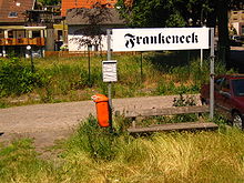
In 1909 Frankeneck was connected to the railway network by the cuckoo train that runs from Lambrecht to Elmstein ; the section to the Sattelmühle was built in 1902 as a pure freight railway. In 1960 passenger traffic was stopped; the freight followed in 1977. Meanwhile, the route serves exclusively as a heritage railway . The stop and former station Frankeneck is located in the district of Lambrecht not far from the north-eastern edge of the settlement of the local community. During the time of the Bavarian State Railways it was listed as "Station Type 2". Since the space in the Lambrecht train station was cramped and it had reached the limits of its capabilities, it also functioned as the Lambrecht freight yard for decades . A few years after the branch line was closed, it was converted into the "Frankeneck station section of the Lambrecht Bf (Pfalz)". Julius Glatz GmbH has a siding until 2004 and again since 2009 .
With the regular opening of the railway line in 1909, the station was the only intermediate station along the route to receive a reception building , which was comparatively small due to its rather minor importance. It was demolished in the mid- 1970s and rebuilt 200 meters away not far from the local valley road. By the turn of the millennium , however, it was no longer inhabited and dilapidated.
Street
The federal highway 39 touches the northeastern edge of the settlement. State road 499 , which runs through the Elmstein Valley to Waldfischbach-Burgalben, runs through the village itself . From this, in the extreme south of the municipality, the county road 23 branches off to Esthal.
tourism
A hiking trail that is marked with a green and white bar and leads from Hertlingshausen to Sankt Martin and a path marked with a yellow and red bar that runs from Lichtenberg Castle to Wachenheim run through the forest .
Personalities
Honorary citizen
- Karl Erhard Scheufelen, entrepreneur
Sons and daughters of the church
- Walter Faller (1909–2003), politician (SPD)
People who worked on site
- Georg Köber , 1792/93 member of the Rhine-German National Convention
- Frank Schwender, multiple medalist at the " World Championships in Christmas Tree Throwing "
literature
- Literature about Frankeneck in the Rhineland-Palatinate State Bibliography
Web links
Individual evidence
- ↑ State Statistical Office of Rhineland-Palatinate - population status 2019, districts, communities, association communities ( help on this ).
- ↑ KommWis, as of December 31, 2013
- ^ The Regional Returning Officer RLP: City Council Election 2019 Frankeneck. Retrieved October 18, 2019 .
- ^ The Regional Returning Officer Rhineland-Palatinate: Municipal elections 2014, city and municipal council elections
- ^ The Regional Returning Officer RLP: direct elections 2019. see Lambrecht (Pfalz), Verbandsgemeinde, third line of results. Retrieved October 18, 2019 .
- ↑ Ewald Metzger: The Frankeneck municipal council can begin its new legislative period. Mittelpfalz.de, news portal in the Verbandsgemeinde Lambrecht, August 21, 2019, accessed on October 18, 2019 .
- ^ Karl Heinz Debus: The great book of arms of the Palatinate. Gräber, Neustadt an der Weinstrasse 1988, ISBN 3-9801574-2-3 .
- ↑ Reiner Frank: Railway in the Elmsteiner Valley then and now . 2001, p. 9 .


