Hochspeyerbach
| Hochspeyerbach | ||
|
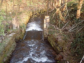
Hochspeyerbach near Weidenthal |
||
| Data | ||
| Water code | DE : 23784 | |
| location | Palatinate Forest , Rhineland-Palatinate , Germany | |
| River system | Rhine | |
| Drain over | Speyerbach → Rhine → North Sea | |
| source | in Hochspeyer 49 ° 26 '27 " N , 7 ° 53' 34" E |
|
| Source height | 267 m above sea level NHN | |
| muzzle | near Frankeneck from the left in the Speyerbach Coordinates: 49 ° 22 '34 " N , 8 ° 3' 12" E 49 ° 22 '34 " N , 8 ° 3' 12" E |
|
| Mouth height | approx. 170 m above sea level NHN | |
| Height difference | approx. 97 m | |
| Bottom slope | approx. 4.5 ‰ | |
| length | 21.3 km | |
| Catchment area | 119 km² | |
| Drain |
MQ |
841 l / s |
| Left tributaries | Fischbach , Glasbach , Erlenbach | |
| Right tributaries | Leinbach | |
| Communities | Hochspeyer, Frankenstein , Weidenthal , Neidenfels , Frankeneck | |
The Hochspeyerbach is a 21 km long stream in the Palatinate Forest in Rhineland-Palatinate and a left tributary of the Speyerbach .
Surname
The medieval name Hospira of the Hochspeyerbach is proven as early as the 10th century; it may have been derived from the Speyerbach ( Spira , Spiraha ).
Another theory says: "According to this theory, the word Spiraha would be formed from ahd. Spiwan = spit (also not known as spiran, but can be deduced from mhd. Spiren) and the ancient suffix -aha = (flowing) water, Originally related to the Latin aqua = water. Spiraha would mean gushing out, spewing out water , whereby the source would have given the river its name. "
geography
course
The Hochspeyerbach has its source in the municipality of Hochspeyer in the immediate vicinity of the swimming pool. In earlier times the brook was dammed about 200 m after the source, the lake was a bathing place; the spring pond, which has recently been created as a biotope , overflows into an underground pipe system. About 600 m to the east the brook comes out again and flows eastward through Hochspeyer parallel to the Mannheim – Saarbrücken railway line . After crossing under the connecting loops to the Alsenz Valley Railway , it takes the Fischbach from the left . A few kilometers further, it flows through the former Franzosenwoog reservoir . At the entrance to Frankenstein , the Glasbach flows out of the Diemerstein valley from the left . In the local area of Frankenstein, the stream changes its direction noticeably and then flows in a south-easterly direction parallel to the B 39 beginning in the village towards Neustadt an der Weinstrasse . One kilometer after Frankenstein he takes the Leinbach from the right . After that it flows through even the communities Weidenthal and Neidenfels before on the municipal boundary between Frankeneck and Lambrecht from the left in the Speyerbach flows .
Tributaries
- Springentalbach ( right ), 0.6 km
- Münchhoferbach ( right ), 0.4 miles
- Fischbach ( left ), 3.1 km
- Glasbach ( left ), 3.7 km
- Erlenbach ( left ), 2.8 km
- Leinbach (right), 14.3 km
- Langentalbach ( right ), 1.4 km
- Weisenbach ( right ), 1.6 km
- Russmühlenbach ( right ), 0.8 km
- Retschbach ( left ), 1.0 km
particularities
The Hochspeyerbach no longer has a natural stream bed anywhere. Immediately after the source it runs in a pipe, then in a canal in the local area of Hochspeyer. In the other places, too, it is partly canalised and partly piped. From the inflow of the Fischbach it was straightened very early for the Trift and the banks were fortified. For this purpose, wood wickerwork was used in earlier times, and stone from the middle of the 19th century. The brook floor was also paved with stones. These fastenings, made without any mortar, are still intact today, with the exception of a few places.
Web links
- Course and catchment area of the Hochspeyerbach on the online map server for the state information system of the Rhineland-Palatinate Nature Conservation Administration (LANIS)
- Speyerbach.info
Individual evidence
- ↑ William Ludt: Hochspeyer - The story of a village f, p. 18
- ↑ Martin Grund, Heinz Schimpf: The special history of the Speyerbach. Retrieved March 31, 2008 .
