
Glasbach (Hochspeyerbach)
| Glasbach | ||
 |
||
| Data | ||
| Water code | DE : 237844 | |
| location |
Haardt Mountains
|
|
| River system | Rhine | |
| Drain over | Hochspeyerbach → Speyerbach → Rhine → North Sea | |
| source | in the Diemersteiner Wald northwest of Frankenstein 49 ° 27 ′ 49 ″ N , 7 ° 56 ′ 45 ″ E |
|
| Source height | 307 m above sea level NN | |
| muzzle | near Frankenstein in the Hochspeyerbach Coordinates: 49 ° 26 '22 " N , 7 ° 58' 1" E 49 ° 26 '22 " N , 7 ° 58' 1" E |
|
| Mouth height | 242 m above sea level NN | |
| Height difference | 65 m | |
| Bottom slope | 18 ‰ | |
| length | 3.7 km | |
| Catchment area | 13.647 km² | |
| Left tributaries | Seven Wells Brook | |
| Reservoirs flowed through | various fish ponds | |
| Communities | Frankenstein | |
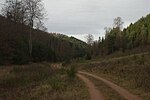
The Glasbach is an approximately 3.7 km long left tributary of the Hochspeyerbach in the Palatinate Forest in Rhineland-Palatinate , Germany .
geography
course
The Glasbach rises at 317 m above sea level. NN from an unconstrained source in the Glastal in the Diemersteiner Forest named after him , on the district of Frankenstein . On its path leading in a south-easterly direction, it takes its strongest tributary after about 500 m from the left, the Siebenquellenbach from the adjacent Vallunga . From there, the Glasbach is the municipality boundary between Frankenstein and Bad Dürkheim .
On its further way, the Glasbach passes some abandoned fish ponds before it flows into the first of four small reservoirs, one behind the other, which were used as fish ponds until a few years ago. They are now owned by NABU .
Then the Glasbach flows past below Diemerstein Castle before being piped for a distance of around 500 m. Thereupon it flows again for about 100 m above ground, through an abandoned pond, before it disappears again in a pipe and only at its end at 242 m above sea level. NN height flows into the Hochspeyerbach from the left .
Tributaries
- Siebenquellenbach ( Langentalbach ) ( left ), 1.0 km
history
The names Glasbach and Glastal came about because a glassworks was located in the valley in modern times until the Thirty Years' War . Thereafter the Glastal remained inhabited until 1812.
In autumn 2009 the upper reaches of the Glasbach fell dry up to the inflow from the Vallunga.

One of the springs feeding the stream (fallen dry here)
The upper Glastal belongs to the neighboring Fischbach

