Frankenstein (Palatinate)
| coat of arms | Germany map | |
|---|---|---|

|
Coordinates: 49 ° 26 ' N , 7 ° 59' E |
|
| Basic data | ||
| State : | Rhineland-Palatinate | |
| County : | Kaiserslautern | |
| Association municipality : | Enkenbach-Alsenborn | |
| Height : | 242 m above sea level NHN | |
| Area : | 13.82 km 2 | |
| Residents: | 926 (Dec. 31, 2019) | |
| Population density : | 67 inhabitants per km 2 | |
| Postal code : | 67468 | |
| Area code : | 06329 | |
| License plate : | KL | |
| Community key : | 07 3 35 010 | |
| Association administration address: | Hauptstrasse 18 67677 Enkenbach-Alsenborn |
|
| Website : | ||
| Local Mayor : | Eckhard Vogel | |
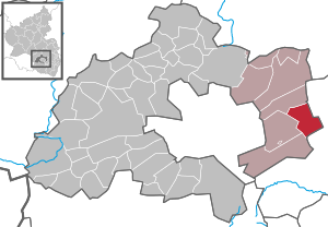
| Location of the local community Frankenstein in the Kaiserslautern district | ||
Frankenstein is a municipality in the Kaiserslautern district in Rhineland-Palatinate . It has been a member of the Enkenbach-Alsenborn community since July 1, 2014 .
geography
Geographical location
Frankenstein is located in the Palatinate in the middle of the Palatinate Forest in the city triangle of Kaiserslautern , Neustadt an der Weinstrasse and Bad Dürkheim . It is located directly at the transition from the Middle to the Lower Palatinate Forest . The north of the district is part of the Diemerstein forest . The community also forms the eastern end of the Kaiserslautern district. Your boundary protrudes like a wedge into the neighboring Bad Dürkheim district . In a clockwise direction, neighboring communities are Bad Dürkheim, Weidenthal (both districts of Bad Dürkheim), Waldleiningen , Hochspeyer and Fischbach (near Kaiserslautern) (all districts of Kaiserslautern).
Community structure
The local community of Frankenstein includes the district of Diemerstein as well as the residential areas Alte Straße, Bordmühle am Leinbach, Bordmühle an der Kehr, Galgental, Klaftertalerhof and Rußhütte.
Surveys
Striking elevations on the municipality markings are the 424.3 meter high Schlossberg of Frankenstein Castle , which is located near the settlement , and the 424 meter high Schlossberg of Burg Diemerstein in the northwest of the municipality. In the extreme south on the border with Waldleiningen and Weidenthal is the 439 meter high Hohe Loog and in the west on the border with Hochspeyer the 422 meter high Hohe Kopf .
Waters
The central flowing water is the Hochspeyerbach , which initially runs in a west-east direction, which changes the direction of flow to north-south in the middle of the Frankenstein settlement area. In the west on the border to Hochspeyer it flowed through the now defunct Franzosenwoog in the 19th century . Shortly before reaching the development, the brook takes on the Glasbach from the left , which in its upper reaches forms the boundary to Bad Dürkheim and further east the Erlenbach .
In the south of the municipality, the Leinbach flows into the Hochspeyerbach from the right . In the Frankenstein area, the former first takes on the Finsterbach from the left , then flows through the Biedenbacher Woog , before it takes up the Bittenbach from the right and passes the Mühlwoog shortly before the mouth .
history
By the end of the 18th century, Frankenstein formed a condominium as it belonged jointly to the Electoral Palatinate and the Counts of Leinigen . It then formed a community with the neighboring Diemerstein.
From 1798 to 1814, when the Palatinate was part of the French Republic (until 1804) and then part of the Napoleonic Empire , Frankenstein and Diemerstein were incorporated into the canton of Kaiserslautern and were under the Mairie Hochspeier . In 1815 the place Austria was added. Just one year later, the place, like the entire Palatinate, changed to the Kingdom of Bavaria . From 1818 to 1862 the community belonged to the Land Commissioner Kaiserslautern ; from this the district office of Kaiserslautern emerged.
Frankenstein has been part of the Kaiserslautern district since 1939 . After the Second World War , the place became part of the then newly formed state of Rhineland-Palatinate within the French occupation zone . In the course of the first administrative reform in Rhineland-Palatinate , the municipality was added to the newly formed Hochspeyer association in 1972 . Frankenstein has been part of the Enkenbach-Alsenborn community since 2014 .
Residents
Population development
| year | 1618 | 1648 | 1787 | 1800 | 1815 | 1823 | 1855 | 1900 | 1905 | 1946 | 1950 | 1956 | 1961 | 1969 | 1980 | 1990 | 1996 | 2004 | 2017 |
|---|---|---|---|---|---|---|---|---|---|---|---|---|---|---|---|---|---|---|---|
| population | 75 | 45 | 355 | 414 | 352 | 607 | 710 | 818 | 858 | 968 | 1147 | 1302 | 1332 | 1469 | 1213 | 1078 | 977 | 1083 | 959 |
| source | (1) | (1) |
religion
The Catholics belong to the diocese of Speyer and are subordinate to the dean's office in Kaiserslautern . The local Catholic Church, the Holy Trinity , is the converted, former synagogue of the village. The Palatinate Israelite community donated it to the church in 1933, with the condition that it be used as a religious space, as its Frankenstein community had dissolved. It was in 1935 inside by the artist Paul Thalheimer painted, a staunch opponent of Nazism , in 1938 in Ludwig Church Bad Durkheim , Adolf Hitler represented as a criminal on the cross. In 1936 he donated the Way of the Cross of the House of God, which he also created.
The Evangelicals belong to the Protestant Church of the Palatinate. On the Protestant side, Frankenstein forms a parish together with Weidenthal and Neidenfels .
The Jews living in the village were buried in Mehlingen .
politics
Municipal council
The local council in Frankenstein consists of twelve council members, who were elected in the local elections on May 26, 2019 in a personalized proportional representation, and the honorary local mayor as chairman. In 2019, the CDU and AfD formed the parliamentary group “Progress Frankenstein”. The CDU councilor was expelled from the party. Up to 2014 the council had 16 council members.
The distribution of seats in the municipal council:
| choice | SPD | CDU | AfD | FWG | total |
|---|---|---|---|---|---|
| 2019 | - | 1 | 1 | 10 | 12 seats |
| 2014 | 4th | - | - | 8th | 12 seats |
| 2009 | 5 | - | - | 11 | 16 seats |
| 2004 | 5 | 1 | - | 10 | 16 seats |
- FWG = Free Voting Group Frankenstein e. V.
Local mayor
Eckhard Vogel (FWG) has been the local mayor since 2009 and was re-elected in 2014 and 2019. In the direct election on May 26, 2019, he achieved a share of the vote of 81.85%.
coat of arms
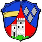
| Blazon : "In blue an ascending, curved red tip, in it a single-towered silver pinnacle castle on a green three-hill, on the left a golden bar, on the right two silver diamond stones placed over one" | |
Culture
Cultural monuments
The old cemetery is designated as a monument zone .
There are also numerous individual monuments, including Frankenstein Castle , which gave the place its name. It was first mentioned in 1146 as a protective castle of the Limburg monastery . Another castle in the village is the castle Diemerstein in the district Diemerstein of 1216. In addition, there is the Villa Denis .
nature
The municipality is located in the Palatinate Forest Nature Park , which in turn belongs to the Palatinate Forest-Vosges du Nord biosphere reserve , which is protected by UNESCO . The monolith of Frankenstein is located in the south of the parish . In addition, there are a total of eleven natural monuments on site , including the Kehrfelsen and the Woogfelsen .
Sports
The sports area Köpfchen has a grass and hard court for soccer as well as various athletics facilities.
Knight stones
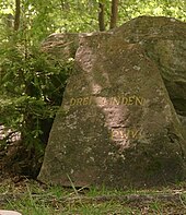
There are a total of six knight stones in the district of Frankenstein . The one with the number 154 is called Griesenfels and marks the rock formation of the same name. 155 The water stone is located in a depression that is reminiscent of a bowl. 156 Biedenbacherwoog is true to the Woog of the same name. 159 Drei Linden marks the location of three linden trees; Immediately next to this is the Ritterstein 160 with the inscription Hochstraße , which indicates an ancient traffic route. 164 Rattenfels represents a rock formation, the weathering of which shows similarities with caves of rats. 165 hunger wells are located at a spring that only brings up water when it rains heavily.
societies
In addition, Frankenstein, together with the neighboring village of Weidenthal, has a local branch of the Palatinate Forest Association , which was awarded the Eichendorff plaque in 2006.
Events
A well-known event in Frankenstein is the winter burning with summer day game with winter burning organized by the community of Frankenstein and the children and youth group of NABU . In addition, there is an Easter market and the so-called Kerwe on site. Together with Waldleiningen and Hochspeyer , the Triftfest is organized on the Biedenbacher Woog in the Leinbachtal .
The corps student association Krischertisch from Neustadt took over an Easter trip annually from 1908, which led to Frankenstein among other places.
Economy and Infrastructure
economy
Due to the geographic conditions, the forest and timber industry dominated the area for centuries. The local forest areas belong to the Otterberg State Forest .
traffic
- rail
Frankenstein is on the Mannheim – Saarbrücken railway , which emerged from the Palatinate Ludwig Railway . The lying on the western edge of settlement station was opened in late 1848, when the since July of the year in operation section Homburg - Kaiserslautern has been extended until Frankenstein. A year later, the full length of the line from Ludwigshafen to Bexbach was in operation. In the meantime, the train station has been dismantled to the halt. Frankenstein has been integrated into the RheinNeckar S-Bahn network since 2003 . In the Frankenstein area, the route also passes the Schlossberg tunnel , the Kehre tunnel and the north side of the Eisenkeil tunnel .
- Street
The Ritter post office, built in 1763, was once an important post station before it was demolished in 2012 due to the risk of collapse.
The federal highway 37 , which leads from Kaiserslautern via Bad Dürkheim to Ludwigshafen am Rhein , runs directly through the town . The federal highway 39 begins in the center and ends in Mainhardt in Baden-Württemberg . The next motorway junction is at Enkenbach-Alsenborn (17) on federal motorway 6 Saarbrücken - Waidhaus about nine kilometers away. The district road 46 also connects the Diemerstein district.
education
Frankenstein has a Protestant kindergarten. The primary school was closed after the 2017/2018 school year due to insufficient student numbers.
tourism
Several hiking trails lead over Frankenstein. Below is one that is marked with a green-blue bar and runs from Göllheim to Eppenbrunn . Another is marked with a white-green bar and leads from Enkenbach-Alsenborn to Maikammer ; another marked with a green-red bar and connects the place with Kaiserslautern and Kleinkarlbach . There is also one that is marked with a yellow bar and runs from Glanbrücken to Wachenheim an der Weinstrasse . The path, one of the so-called Saar-Rhein hiking trails, marked Schwarzer Punkt on a white bar , also runs through Frankenstein and leads from Saarbrücken to Rülzheim.
The Nahegau-Wasgau-Vosges long-distance hiking trail marked with a white cross and one marked with a white-blue bar runs through the north-west of the district .
Personalities
Honorary citizen
- Willi Koppenhöfer, appointed 1985, local mayor from 1960 to 1992; He had exercised this office "with a great deal of public spirit, great expertise and persistent energy for the benefit of the citizens of Frankenstein".
- August Hinkel, appointed in 1994 "for 40 years of activity in local politics".
Sons and daughters of the church
- Carl Adolph Ritter (1794–1863), politician
- Ludwig Sebastian (1862–1943), bishop in the Diocese of Speyer (1917–1943)
- Manfred Petry (* 1953), politician (FW), local mayor from 1992 to 2009, since 2007 regional chairman of the state association of Free Voting Groups Rhineland-Palatinate e. V. and since 2010 the party of Free Voters Rhineland-Palatinate
People who worked on site
- Wilhelm Michel (1877–1942), writer, grew up there
- Arno Platzbecker (1894–1956), painter, his works were exhibited in 2011 in the Villa Denis
- Karl Albrecht von Ritter (1836–1917), forest clerk, government director and founding chairman of the Palatinate Forest Association, worked temporarily as a forest assistant on site
literature
- Karl Lieser: Frankenstein and Diemerstein. Old time images. Arbogast, Otterbach 1996, ISBN 3-87022-225-5 .
Web links
- Internet presence of the local community Frankenstein
- Literature about Frankenstein in the Rhineland-Palatinate State Bibliography
Individual evidence
- ↑ State Statistical Office of Rhineland-Palatinate - population status 2019, districts, communities, association communities ( help on this ).
- ↑ State Statistical Office Rhineland-Palatinate (ed.): Official directory of the municipalities and parts of the municipality. Status: January 2019 [ Version 2020 is available. ] . S. 149 (PDF; 3 MB).
- ↑ State Statistical Office Rhineland-Palatinate - regional data
- ^ Website of the diocese of Speyer
- ↑ Frankenstein: Planned CDU-AfD cooperation causes trouble. In: The Rhine Palatinate. July 3, 2019, accessed July 3, 2019 .
- ↑ Exclusion from the party because of the faction community with the AfD. Deutschlandradio, accessed on October 22, 2019 .
- ^ The Regional Returning Officer Rhineland-Palatinate: Local elections 2019, city and municipal council elections. Retrieved July 30, 2019 .
- ↑ The regional returning officer RLP: direct elections 2019. see Enkenbach-Alsenborn, Verbandsgemeinde, third line of results. Retrieved October 26, 2019 .
- ↑ enkenbach-alsenborn.de: HONOR CITIZENS OF THE ENKENBACH-ALSENBORN ASSOCIATION ( Memento from May 30, 2019 in the Internet Archive )


