Mackenbach
| coat of arms | Germany map | |
|---|---|---|

|
Coordinates: 49 ° 28 ' N , 7 ° 35' E |
|
| Basic data | ||
| State : | Rhineland-Palatinate | |
| County : | Kaiserslautern | |
| Association municipality : | Weilerbach | |
| Height : | 264 m above sea level NHN | |
| Area : | 3.53 km 2 | |
| Residents: | 1983 (Dec. 31, 2019) | |
| Population density : | 562 inhabitants per km 2 | |
| Postal code : | 67686 | |
| Area code : | 06374 | |
| License plate : | KL | |
| Community key : | 07 3 35 024 | |
| LOCODE : | DE MCB | |
| Association administration address: | Rummelstrasse 15 67685 Weilerbach |
|
| Website : | ||
| Local Mayor : | Daniel Schäffner ( SPD ) | |
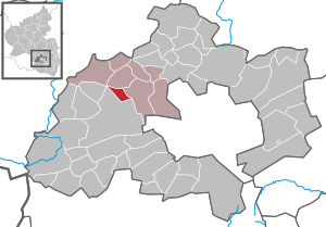
| Location of the local community Mackenbach in the district of Kaiserslautern | ||
Mackenbach is a municipality in the Kaiserslautern district in Rhineland-Palatinate . It belongs to the community of Weilerbach .
geography
Mackenbach is 13 km northwest of Kaiserslautern . The Langenfelderhof residential area also belongs to the community .
history
Mackenbach was first mentioned in 1281 indirectly. A Cunrat von Magkinbach is mentioned in the Rheinpfälzer documents no. 2089 in the main state archive in Munich . Further mentions are 1413 Jakop von Mackenbach (R. Breid. 126); 1510 (Or.) “A waeg zumachenbach” (GI.NU291); Mackenbach (LA Sp F 3/10, fol. 14) (Or.) Mackenbacher bann (Reichsld. 69) 1797 Mackenbach (Schmitt'sche Karte 9).
The place was created around the year 1000, but was first mentioned in a document in 1510.
Until the end of the 18th century, Mackenbach belonged to the Palatinate court of Steinwend . In 1787 the parish had 47 families and 200 residents. Two school houses and 33 residential buildings were recorded. The district Mackenbach included 698 acre arable land, 89 acres of meadows, 6 acres of gardens and 91 acres of wood and five ponds .
In 1794, French revolutionary troops had taken the left bank of the Rhine . From 1798 to 1814 the region and thus also the municipality of Mackenbach belonged to the canton of Landstuhl in the Donnersberg department . It was under the administration of Mairie Ramstein. In 1802 Mackenbach had 249 inhabitants: 58 Catholics , 100 Reformed and 91 Lutherans .
Due to the agreements made at the Congress of Vienna and an exchange contract with Austria , the Palatinate came to the Kingdom of Bavaria in 1816 . The municipality of Mackenbach in the canton of Landstuhl , which was part of the Landkommissariat Homburg (renamed District Office Homburg in 1862 ) in the Rhine district, remained under the Bavarian administration . In 1837 Mackenbach in the Palatinate (Bavaria) already had 604 inhabitants. Of these, 89 were Catholics and 515 Protestants .
In the Bavarian local register from 1928, the rural community of Mackenbach, now part of the Bavarian administrative district Palatinate and the district office of Kaiserslautern , is described as follows: a total of 1,408 inhabitants (144 Catholics and 1,264 Protestants), 237 residential buildings and an area of 354 hectares; there was a Protestant parish, a denominational community school and a post office in the village.
politics
Municipal council
The municipal council in Mackenbach consists of 16 council members, who were elected in a personalized proportional representation in the local elections on May 26, 2019 , and the honorary local mayor as chairman.
The distribution of seats in the municipal council:
| choice | SPD | CDU | FWG | total |
|---|---|---|---|---|
| 2019 | 9 | 3 | 4th | 16 seats |
| 2014 | 9 | 7th | - | 16 seats |
| 2009 | 9 | 5 | 2 | 16 seats |
| 2004 | 9 | 3 | 4th | 16 seats |
mayor
Local mayor of Mackenbach is Daniel Schäffner (SPD). In the direct election on May 26, 2019, he was elected with 79.78% of the vote, making him the successor to Jürgen Steinhauer (SPD), who did not run again.
coat of arms
|
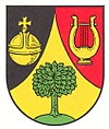
Blazon : "Of black and red through an ascending, curved golden tip, in it a green deciduous tree on a green background, divided, a golden orb at the top right, a golden lyre at the top left."
The coat of arms was approved by the Rhineland-Palatinate Ministry of the Interior in 1960 . |
|
| Justification for the coat of arms: The lyre reminds of the hiking musicians of the village. |
Culture and sights
music
Mackenbach's reputation as a musicians' village was established by the traveling musicians in the mid-19th to the 30s of the 20th century. They moved with bands and circuses all over the world and made music worldwide (all over Europe, but also in the USA, Australia and Africa) to offset the meager income from agriculture.
Today, the music is still cultivated in the Liederkranz men's choir, in the music association and in the Protestant church choir.
Museums
The West Palatinate Musicians Museum is dedicated to the West Palatinate hiking musicians.
Buildings
see list of cultural monuments in Mackenbach
Sports
In addition to a football club's grass and hard court, there is a skate park for inline skaters and skateboarders , an indoor tennis center and a tennis club with four open-air courts , as well as an 18-hole golf course in Mackenbach . Table tennis is played in the multi-purpose hall, which is also used by the village's primary school. The chess room is in the immediate vicinity. The sports mentioned are practiced in three sports clubs.
Regular events
On Rose Monday, a Rose Monday ball takes place in the multi-purpose hall (community center). Furthermore, the Kerwe is celebrated on the second weekend in September . The annual Christmas market takes place on the Saturday before the 3rd Advent.
traffic
The public transport in the transport association Rhein-Neckar integrated.
The community is connected to the motorway network by the A 6 (junctions: Kaiserslautern -West , further on Landesstraße 367 or Kaiserslautern-Einsiedlerhof , further on the L 369).
Sons and daughters of the church
- Karl-Heinz Werle (1925–2009), politician (SPD)
- Rolf Brederlow (* 1961), actor
Web links
- Mackenbach municipality
- Literature about Mackenbach in the Rhineland-Palatinate state bibliography
Individual evidence
- ↑ State Statistical Office of Rhineland-Palatinate - population status 2019, districts, communities, association communities ( help on this ).
- ↑ State Statistical Office Rhineland-Palatinate (ed.): Official directory of the municipalities and parts of the municipality. Status: January 2019 [ Version 2020 is available. ] . S. 152 (PDF; 3 MB).
- ↑ Source: Hobelsberger-Rhodes, Andreas / HR Wittner
- ^ Johann Goswin Widder : Attempt of a complete geographical-historical description of the Kurfürstl. Pfalz am Rheine , Volume 4, Frankfurt and Leipzig, 1788, p. 283 ( Google Books )
- ^ PA Müller: Statistical yearbook for the German states between the Rhine, the Moselle and the French border , Mainz: Kupferberg, 1815, p. 159 ( Google Books )
- ↑ a b Michael Frey : Attempt at a geographical-historical-statistical description of the king. bayer. Rheinkreises , Volume 4, Neidhard, 1837, p. 187 ( Google Books )
- ^ Localities directory for the Free State of Bavaria , based on the census of June 16, 1926 and the territorial status of January 1, 1928, column 744 ( Digitale-sammlungen.de )
- ^ The Regional Returning Officer Rhineland-Palatinate: Mackenbach municipal council election 2019. Retrieved October 28, 2019 .
- ^ The Regional Returning Officer Rhineland-Palatinate: Municipal elections 2014, city and municipal council elections.
- ↑ The Regional Returning Officer Rhineland-Palatinate: direct elections 2019. Retrieved on October 28, 2019 (see Weilerbach, Verbandsgemeinde, fourth row of results).
- ^ Karl Heinz Debus: The great book of arms of the Palatinate. Neustadt an der Weinstrasse 1988, ISBN 3-9801574-2-3 .


