Olsbrücken
| coat of arms | Germany map | |
|---|---|---|

|
Coordinates: 49 ° 32 ' N , 7 ° 40' E |
|
| Basic data | ||
| State : | Rhineland-Palatinate | |
| County : | Kaiserslautern | |
| Association municipality : | Otterbach-Otterberg | |
| Height : | 209 m above sea level NHN | |
| Area : | 7.22 km 2 | |
| Residents: | 1053 (Dec. 31, 2019) | |
| Population density : | 146 inhabitants per km 2 | |
| Postal code : | 67737 | |
| Area code : | 06308 | |
| License plate : | KL | |
| Community key : | 07 3 35 033 | |
| LOCODE : | DE OLJ | |
| Association administration address: | Hauptstrasse 27 67697 Otterberg |
|
| Website : | ||
| Local Mayor : | Walter Schneck ( SPD ) | |
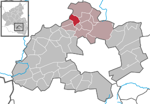
| Location of the municipality of Olsbrücken in the Kaiserslautern district | ||
Olsbrücken is a municipality in the Kaiserslautern district in Rhineland-Palatinate . It belongs to the Verbandsgemeinde Otterbach-Otterberg .
geography
Geographical location
Olsbrücken is located in the northern part of the Kaiserslautern district . All around are the hills of the North Palatinate Uplands .
Neighboring communities
The parish borders on Kreimbach-Kaulbach in the Kusel district in the north, Wörsbach in the northeast, Schallodenbach in the east, Mehlbach in the southeast, Hirschhorn / Pfalz in the south and Sulzbachtal and Frankelbach in the west.
Local division
The Olsbrücker streets bear the names: Am Berg, Am Hahngraben, Am Rutzenbach, Am Waldhof, Auf den Wingerten, Bachstraße, Bahnhofstraße, Bornweg, Dietenbachstraße, Hauptstraße, Hebelstraße, Hohlstraße, Im Holzgraben, Im Kirschgarten, Kirchweg, Schneidersäcker and Wörsbacher Straße. The street Am Habel exists, but it is a driveway to a single private house.
The district of the local community includes over 100 trade names . Many of them are known to the local population.
The two mills used to be decisive in the townscape . The Neumühle at the northern exit of the village in the direction of Kreimbach-Kaulbach , as well as the Oppensteiner Mühle to the south, about one kilometer before the village entrance. While the Neumühle building still exists, the Oppensteiner Mühle fell victim to the straightening of the local federal road in the late 1970s. Coming from Kaiserslautern on the left in the direction of travel some remains of the mill wall survived in the undergrowth next to the road.
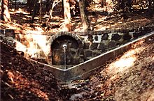
The name "Auf den Wingerten" refers to a former vineyard that must have been in the local area. The two larger forests in the Olsbrücker district are called Tierwald and Seiderswald. The enclosed spring of the snake fountain is located in the animal forest.
Elevations and waters
The Oberberg extends south of the settlement area
Olsbrücken is located in the valley of the Lauter river , which also forms the boundary with Frankelbach. This takes on the Rutzenbach and the Holzgraben from the right . The Dietenbach also flows into the latter from the right . There is also the Oppensteiner Brunnen on site.
climate
The climate of the Palatinate is generally one of the mildest and sunniest in Germany . The West Palatinate is a little cooler than the areas on the Rhine , but there is plenty of sunshine. The winter are rarely determined by longer periods of snow and ice.
history
The area around Olsbrücken was already settled in Roman times. A road led over the surrounding hills , in the neighboring village of Kreimbach-Kaulbach there are still remains of the Heidenburg to be seen. In the Middle Ages Olsbrücken was mentioned for the first time proven. It was named Alsbrucken, then Holszbrücken and then Olszbrücken, which suggests that there were probably eels in the Lauter. In the Thirty Years' War , probably around 1635, two villages between Olsbrücken and today's Sulzbachtal were completely destroyed and not rebuilt. Olsbrücken, however, was rebuilt.
At the end of the 18th century, the western Electoral Palatinate became French . Napoleon initiated extensive administrative reforms and introduced the civil code . From 1798 to 1814, when the Palatinate was part of the French Republic (until 1804) and then part of the Napoleonic Empire , the municipality was incorporated into the canton of Otterberg and the Département du Mont-Tonnerre ( Donnersberg ). In 1815 the place first belonged to Austria . A year later he moved to the Kingdom of Bavaria . From 1818 to 1862 Olzbrücken belonged - as the spelling at that time - to the Land Commissioner Kaiserslautern ; from this the district office of Kaiserslautern emerged. In the 19th century , many people from the Palatinate also emigrated to the United States .
The community has been part of the Kaiserslautern district since 1939 . After the Second World War , Olsbrücken became part of the then newly formed state of Rhineland-Palatinate within the French occupation zone . In the post-war period , the new development areas Am Waldhof, Am Rutzenbach, Im Kirschgarten, Holzgraben and, most recently, the new development areas Auf den Wingerten and Am Friedhof were built . In the course of the first Rhineland-Palatinate administrative reform , the place was incorporated into the newly created Verbandsgemeinde Otterbach in 1972 , which merged with the Verbandsgemeinde Otterberg to form the new Verbandsgemeinde Otterbach-Otterberg on July 1, 2014 .
religion
In 2012, 58.8 percent of the population were Protestant and 24.6 percent Catholic. The rest belonged to another religion or were non-denominational. The Catholics belong to the Diocese of Speyer , the Evangelicals to the Protestant Church of the Palatinate .
politics
Municipal council
The local council in Olsbrücken consists of 16 council members, who were elected in a personalized proportional representation in the local elections on May 26, 2019 , and the honorary local mayor as chairman.
The distribution of seats in the municipal council:
| choice | SPD | CDU | FWG | total |
|---|---|---|---|---|
| 2019 | 8th | 5 | 3 | 16 seats |
| 2014 | 7th | 6th | 3 | 16 seats |
| 2009 | 6th | 7th | 3 | 16 seats |
| 2004 | 6th | 7th | 3 | 16 seats |
- FWG = Free Voting Group Olsbrücken-Frankelbach e. V.
Local mayor
| Term of office | Surname | Political party |
|---|---|---|
| 1981-1989 | Arthur Hesch | CDU |
| 1989-2004 | Gerhard Klein | SPD |
| 2004-2008 | Regina Hill | SPD |
| 2008-2019 | Peter Hesch | CDU |
| since 2019 | Walter Schneck | SPD |
In the direct election on May 26, 2019, Walter Schneck was elected with 58.74% of the vote.
coat of arms
| Blazon : "In blue a two-arched brick silver bridge, underneath a swimming silver eel." | |
| Reasons for the coat of arms: The coat of arms shows a bridge and an eel. It symbolizes the original meaning of the place name Alsbrücken . |
Culture and sights
Cultural monuments

The Jewish cemetery is designated as a monument zone .
In addition, there are a total of ten individual objects that are under monument protection .
nature
There are a total of five natural monuments on site .
Economy and Infrastructure
economy
There is a branch of the Volksbank Lauterecken on site .
traffic
With the opening of the Lautertalbahn Kaiserslautern - Lauterecken in 1883, the community was connected to the railway network. The Olsbrücker Bahnhof is already on the border of the neighboring community Frankelbach . The public transport in the transport association Rhein-Neckar integrated.
The federal highway 270 runs directly through the community and leads from Kaiserslautern via Wolfstein and Lauterecken to Idar-Oberstein . The circuit road 27 provides a connection to Frankelbach forth and the circuit road 28 to Lower churches. The community is connected to the motorway network by the A 6 (junction: Kaiserslautern-West).
education
There is a primary school and a community library in Olsbrücken.
tourism
Since 1971, the hut on the Oberberg has been located within the municipality marker in the Oberberg Gewanne , which serves as the clubhouse of the local branch of the Palatinate Forest Association . The Lautertal cycle path runs right through the village and connects Olsbrücken with Kaiserslautern and Lauterecken . Olsbrücken is also the starting point for the Lautertal - Moorbachtal - Glan-Blies cycle path .
Personalities
Sons and daughters of the church
- Rudolf Henn (1880–1955), sculptor
- Hermann Bitz (* 1950), football player
People who worked on site
- Laura Kloos (* 1990), singer-songwriter, lives in Olsbrücken
- Anne Rheinheimer (* 1993), soccer player, played in her youth at TuS Olsbrücken
Web links
- Local community Olsbrücken on the website of the Verbandsgemeinde Otterbach-Otterberg
- Literature about Olsbrücken in the Rhineland-Palatinate state bibliography
Individual evidence
- ↑ State Statistical Office of Rhineland-Palatinate - population status 2019, districts, communities, association communities ( help on this ).
- ↑ KommWis, as of December 31, 2012
- ^ The Regional Returning Officer Rhineland-Palatinate: Local elections 2019, city and municipal council elections
- ^ The Regional Returning Officer RLP: direct elections 2019. see Otterbach-Otterberg, Verbandsgemeinde, eleventh line of results. Retrieved October 27, 2019 .


