Louder (Glan)
|
Louder (Waldlauter) |
||
|
River course |
||
| Data | ||
| Water code | DE : 25466 | |
| location | Rhineland-Palatinate , Germany | |
| River system | Rhine | |
| Drain over | Glan → Nahe → Rhine → North Sea | |
| source | At Kaiserslautern 49 ° 25 ′ 36 ″ N , 7 ° 49 ′ 8 ″ E |
|
| Source height | approx. 249 m above sea level NHN | |
| muzzle | At Lauterecken in the Glan Coordinates: 49 ° 39 '2 " N , 7 ° 35' 27" E 49 ° 39 '2 " N , 7 ° 35' 27" E |
|
| Mouth height | approx. 159 m above sea level NHN | |
| Height difference | approx. 90 m | |
| Bottom slope | approx. 2.3 ‰ | |
| length | 39.4 km | |
| Catchment area | 275.649 km² | |
| Left tributaries | Mooslauter | |
| Right tributaries | Eselsbach , Otterbach | |
| Medium-sized cities | Kaiserslautern | |
| Small towns | Wolfstein , Lauterecken | |
|
Artificial spring pond and course of the Lauter in the Neumühlpark of the Kaiserslautern garden show |
||
|
Louder in Wolfstein |
||
|
Ritterstein near the origin of the Lauter |
||
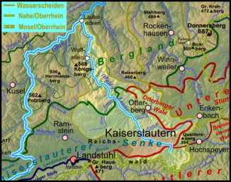
The Lauter , in contrast to the Wieslauter in southern Palatinate, also known as the Waldlauter , is a 39.4 km long right tributary of the Glan in Rhineland-Palatinate , Germany . The Lauter rises in the Palatinate Forest, flows through the Kaiserslauter Senke and then strives towards the Glan through the North Palatinate Uplands .
geography
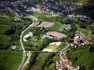
The Lauter rises about 3 km southeast of Kaiserslautern not far from the state road 504 at an altitude of 249 m above sea level. NHN . Their water entfließt the Lauter Spring on so-called Hungerbrunnen . From there it flows north along the state road and reaches the urban area of Kaiserslautern, where it canalised and mostly runs underground. In the garden show an artificial source pond was created, traversed by the "New Loud" from the the Neumühlpark. The piped Lauter and the "Neue Lauter" unite on the northern outskirts at a sewage treatment plant . From there the Lauter flows mainly in a north-westerly direction via Otterbach , Katzweiler , Hirschhorn / Pfalz , Untersulzbach , Olsbrücken , Kreimbach-Kaulbach , Wolfstein , Oberweiler-Tiefenbach , Heinzenhausen and Lohnweiler , to 159 in Lauterecken - the name of which refers to the river m above sea level NHN flows into the Glan on the right .
On its 39.4 km long path, the Lauter overcomes a height difference of 90 m, which corresponds to an average bed gradient of 2.3 ‰. The river drains a 275.649 km² catchment area via Glan, Nahe and Rhine to the North Sea .
Tributaries
The longest tributary of the Lauter is the 12.3 km long Eselsbach . The 10.3 km long Mooslauter has the larger catchment area with 50.517 km². In the following, the tributaries of the Lauter are named in the order from the source to the mouth, which are managed by the Rhineland-Palatinate water management authority. In each case, the orographic position of the mouth, the length, the size of the catchment area, the altitude of the mouth and the river code are given.
| Surname
|
location | Length in km |
EZG in km² |
Mouth height in m above sea level NHN |
GKZ |
|---|---|---|---|---|---|
| Hammerbach | Left | 3.2 | 3.813 | 233 | 25466-2 |
| Eselsbach | right | 12.3 | 27.888 | 226 | 25466-4 |
| Otterbach | right | 9.1 | 29,564 | 217 | 25466-6 |
| Frauenwiesbach | Left | 4.4 | 10,344 | 215 | 25466-72 |
| Kohbach | Left | 1.5 | 0.820 | 214 | 25466-732 |
| Eimerbach | Left | 1.1 | 1,092 | 214 | 25466-734 |
| Becherbach | right | 5.5 | 5.080 | 211 | 25466-74 |
| Mehlbach | right | 5.0 | 3.718 | 210 | 25466-76 |
| Lauterbach | right | 4.7 | 4.259 | 209 | 25466-78 |
| Mooslauter | Left | 10.3 | 50.517 | 209 | 25466-8 |
| Wohlbach | right | 2.4 | 1,979 | 209 | 25466-9112 |
| Sulzbach | Left | 2.3 | 3.603 | 207 | 25466-912 |
| Rutzenbach | right | 3.3 | 2.808 | 205 | 25466-914 |
| Wooden trench | right | 1.9 | 2.865 | 204 | 25466-9192 |
| Frankelbach | Left | 3.8 | 5.085 | 203 | 25466-92 |
| Kaulbach | Left | 2.0 | 1.545 | 202 | 25466-9312 |
| Kreimbach | right | 1.9 | 3.207 | 200 | 25466-932 |
| Schmeißbach | Left | 1.7 | 1.119 | 196 | 25466-934 |
| Lammelbach | Left | 1.8 | 1.923 | 194 | 25466-9392 |
| Selbach | Left | 1.5 | 1,781 | 190 | 25466-952 |
| Rossbach | right | 3.1 | 3.124 | 190 | 25466-94 |
| Breitbach | right | 2.8 | 3,747 | 187 | 25466-954 |
| Koenigsbach | Left | 2.9 | 3,349 | 179 | 25466-96 |
| Mausbach | Left | 2.0 | 2.155 | 166 | 25466-98 |
Notes on the table
- ↑ Water code number , in Germany the official river code number with a separator inserted after the prefix for better readability, which stands uniformly for the Lauter receiving water shared by all .
environment
In the upper reaches, the Lauter is one of the fine-material, silicate low mountain streams (type 5.1). From the mouth of the Frauenwiesbach, the Lauter is one of the fine to coarse material rich, silicate low mountain range rivers (type 9). The structure of the water is largely or completely changed. Below Oberweiler-Tiefenbach , the structural quality is given as clearly to strongly changed. The water quality on the sections Kaiserslautern to Katzweiler and Olsbrücken to Wolfstein is given as critically polluted, otherwise given as moderately polluted (as of 2005).
A renatured section is located next to the sewage treatment plant area, i.e. between Kaiserslautern and Otterbach.
Infrastructure
The Lautertal north of Kaiserslautern is an agricultural, wide meadow valley. It is accessed by the B 270 and the single-track Lautertalbahn Kaiserslautern-Lauterecken. Once a year (beginning of August) the Lautertal between the northern city limits of Kaiserslautern and Lauterecken is closed to motorized traffic from 9:00 a.m. to 6:00 p.m. ( car-free Lautertal ) and is available to cyclists, skaters, pedestrians, etc. on this day .


