
Lauter (Rhine, Neuburg)


The Lauter , in French la Lauter , on the lower reaches in Celtic - Roman times Murga , today on the entire upper reaches in the southern Palatinate Forest , the German part of the Wasgau , up to the French border called Wieslauter , is a left tributary of the Rhine in Rhineland-Palatinate and Alsace ( Grand Est region ). As a body of water III. Classified as orderly , the Lauter drains one of the four major river systems of the Palatinate Forest alongside Speyerbach , Queich and Schwarzbach . Including its main source river, the Wartenbach , it is 74 km long; Via the right tributary Salzbach , its longest flow path even reaches 80 km in length.
Surname
The river bears the name Wieslauter to distinguish it from the second Lauter in the Palatinate , which rises near Kaiserslautern and is also called Waldlauter . The extension of the name to Wies louder is unclear; Two different linguistic sources are discussed: Although the upper section of the stream leads more through forest than through meadows, in view of some broad floodplains, meadow is a conceivable source. The old name “Waschlauterhof” for the hamlet Wieslauterhof, however, makes the fact that the water from the Lauter was used to clean the laundry appear at least as plausible for the naming.
course
The source of the Wieslauter is located in the middle of the Palatinate Forest immediately southeast of the Palatinate main watershed south of Gräfenstein Castle and just above the hamlet of Wieslauterhof in a side valley of the Zieglertal on the Merzalben forest area . The place at 249 m is marked by the knight stone 230 with the inscription "Wieslauter-Ursprung". The brook immediately flows into a woog , a small reservoir, the drainage of which flows after about 500 m from the right into a much richer body of water, the Wartenbach .
At 7.16 km, this is the longest source tributary of the Wieslauter and flows almost parallel to the watershed in a south-westerly direction. First as a raft stream , it emerges at a height of 382 m on the western flank of the Hortenkopf and, as its name suggests, previously served the wood drift . For this purpose it was dammed below its source to the Gambswoog , which is also called the Gambsklause .
About 1.3 km before the confluence of the Wieslauter and Wartenbach rivers, this takes up the 4.3 km long Scheidbach from the left . Its source is 374 m above sea level on the western flank of the 610 m high Weißenberg .
In Hinterweidenthal the Wieslauter flows in a five-part valley spider from the right from almost opposite valley direction to the strongest tributary, the 16 km long Salzbach , which rises as Kröppenbach northeast of the Hohen List . It flows northeast past the hamlets of Glashütte and Langmühle and takes on the Storrbach 2 km before the municipality of Salzwoog .
Shortly before Dahn , the 8 km long, second strongest tributary, Moosbach , also flows from the right and very bluntly ; the Wieslauter flows here to the southeast. It passes Bruchweiler-Bärenbach and takes on the 8 km long Erlenbach flowing from north to south at Niederschlettenbach from the left . 5 km behind Bobenthal , the Wieslauter crosses the state border from Germany to France , where it is then called la Lauter . Immediately afterwards it reaches the Upper Rhine Plain in Wissembourg (Weißenburg, Alsace) .
From here on, the Lauter continues in a south-easterly direction on the southern edge of the Bienwald and essentially forms the border between Germany and France, before it turns left of the old drainage line as Neue Lauter France for the last 5 km at Lauterbourg (Lauterburg, Alsace) leaves again. At Neuburg the Lauter flows into the Rhine after about 74 km at an altitude of 107 m .
The Alte Lauter, south of the new estuary, continues to mark the state border up to its own confluence with the Rhine (4 km). To the right of the estuary is the easternmost point of France, to the left the southernmost point of Rhineland-Palatinate.
history
Towards the end of the 15th century, both the Roman-German emperor and two successive reigning popes , Innocent VIII and Alexander VI. , deal with the " water feud " that Hans von Trotha , knight of Berwartstein Castle, fought with the Weißenburg monastery : First, the knight, who became a child fright in the region's legends, had the Wieslauter dammed up and withdrawn from Bobenthal like the water in the little town of Weißenburg down below; After complaints from the monastery, he tore down the dam and caused a huge flood in Weißenburg with considerable economic damage.
The area around the upper Wieslauter and its source streams belonged to the margraviate of Baden until the beginning of the 19th century ; To the north of the Weißenberg there are still historical boundary stones, and the name “Scheidbach” also indicates a boundary water. With the Treaty of Lunéville (1801), all of Germany on the left bank of the Rhine became formally and under international law part of the French Republic and remained so until Napoleon's disempowerment in 1815.
As a result of the Second World War , the two parts of the German Mundatwald , which lie to the left of the Lauter - north-west and east of Weißenburg - were annexed by France and only returned to Germany in 1986.
Sightseeing and tourism
Natural monuments and cultural sights
The area at the upper reaches of the Lauter, the Dahner Felsenland , is particularly rich in sandstone rock formations , and many mountain peaks have rock castles .

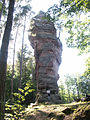
Devil table

Maiden jump

Neudahn Castle
Altdahn Castle


Tourist attractions are, for example, the mushroom rock Teufelstisch near Hinterweidenthal and the 70 m high Jungfernsprung in Dahn, which are legendary. Well-known castles are Neudahn , the Dahner Burgengruppe with Altdahn, Grafendahn and Tanstein, the Drachenfels , which was destroyed in 1523 because of the rebellious knight Franz von Sickingen , and the Berwartstein of the knight Hans von Trotha. With an interior area of 1320 m², the Gothic church of the former Weissenburg monastery , with which the knight Hans fought his "water feud", is impressive .

Drachenfels Castle

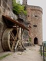
Berwartstein Castle

Collegiate church of the former Weißenburg monastery
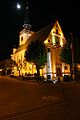
Lauterburg Church


freetime and sports
A cycle path marked by a blue sign with cyclists leads along the Lauter for about 59 km from Hinterweidenthal to the mouth , which is known as the Franco-German Pamina cycle path Lautertal or Wieslautertal cycle path for short .
The Wieslauter also serves as a canoe trail . For reasons of nature conservation , however, the river may only be used with single kayaks without a control blade and only when the water depth is sufficient; at the Bobenthal gauge , the Lauter must be at least 75 cm tall. A corresponding regulation has been in force since 2001.
The Dahner Felsenland, which flows through the Wieslauter, is the heartland of the Palatinate Forest climbing area and is a preferred destination for sport climbers .

Bride and groom climbing rock

Hochstein needle on the Hochstein

Ladder to heaven on the Lämmerfelsen
Ludwigshafen tower on the Durstigfelsen


Web links
- Louder at SANDRE (French)
- Débits caractéristiques de la Lauter (French; PDF file; 28 kB)
Individual evidence
- ↑ a b Old name according to: Albrecht Greule : Deutsches Gewässernamenbuch . Walter de Gruyter, Berlin 2014, p. 364 .
- ↑ a b Map service of the landscape information system of the Rhineland-Palatinate Nature Conservation Administration (LANIS map) ( notes )
- ↑ GeoExplorer of the Rhineland-Palatinate Water Management Authority ( information )
- ↑ According to Débits caractéristiques de la Lauter (see web link) the Lauter has an EZG of 395.3 km².
- ^ German Hydrological Yearbook Rhine Region, Part I 2009 State Institute for Environment, Measurements and Nature Conservation Baden-Württemberg, p. 92, accessed on January 22, 2016 (PDF, German, 1.85 MB).
- ^ German-French Pamina Cycle Route Lautertal. (No longer available online.) Radwanderland.de, formerly in the original ; Retrieved April 14, 2001 . ( Page no longer available , search in web archives )
- ↑ Wieslauter ordinance. (No longer available online.) District administration Südwestpfalz, 2001, archived from the original ; Retrieved April 15, 2011 .
- ↑ Overview map of the Wieslauter ordinance. (PDF; 1.1 MB) (No longer available online.) District administration Südwestpfalz, formerly in the original ; Retrieved April 15, 2011 . ( Page no longer available , search in web archives )