
Wasgau
| Wasgau | |
|---|---|
 Location of the Wasgau (lightened) in the southern part of the Palatinate Forest and in the eastern part of the northern Vosges |
|
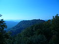
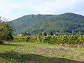
 Typical Wasgau landscape with cone mountains and leveled areas: View from Rehberg to the southwest |
|
| Highest peak | Great Wintersberg ( 581 m above sea level ) for the entire Wasgau; Rehberg ( 576.8 m above sea level ) for the German part |
| location | Rhineland-Palatinate (Germany); Départements Bas-Rhin and Moselle (France) |
| Parts | of the Palatinate Forest (southern part) and the Vosges (northern part) |
| Coordinates | 49 ° 3 ' N , 7 ° 40' E |
| rock | Buntsandstein and Zechstein rock units |
| Age of the rock | Buntsandstein 251–243 million years, Zechstein 256–251 million years |
| surface | about 1,300 km² |
| particularities | diverse relief; bizarre rock formations; Rock castles |
The Wasgau ( French Vasgovie ) is a German - French low mountain range in the state of Rhineland-Palatinate and in the departments of Bas-Rhin and Moselle . It is formed by the southern part of the Palatinate Forest and the eastern part of the Northern Vosges (French: Vosges du Nord ) and extends across the border from the Queich in the north to the Zaberner Steige (French: Col de Saverne ) in the south.
The highest mountain in the entire Wasgau is at 581 m above sea level. NHN the Great Wintersberg near Bad Niederbronn in northern Alsace (French Alsace ). It is followed by the 576.8 m above sea level. NHN only slightly lower Rehberg near Annweiler in the southern Palatinate , which is the highest elevation in the German part of the mountain area.
The Wasgau forms the southern part of the Palatinate Forest-Vosges du Nord biosphere reserve .
geography
location
The Wasgau extends from a line Pirmasens - Landau in the north, which from Wilgartswiesen coincides with the course of the Queich, to the Zaberner Steige or a line Pfalzburg (French Phalsbourg ) - Zabern (French Saverne ) in the south. Its eastern boundary from Albersweiler in Queichtal via Bad Bergzabern , Weißenburg (French: Wissembourg ) in Alsace and Bad Niederbronn (French: Niederbronn-les-Bains ) to Zabern is the western edge of the Rhine plain . In the west, the mountains flow into the landscape of the Westrich plateau ; From there, the younger rock layers of the shell limestone cover the red sandstone that dominates the Wasgau . This natural borderline runs from Pirmasens via Eppenbrunn , Bitsch (French: Bitche ) and Lemberg in Lorraine (French: Lorraine ) to the south and finally reaches the rupture zone of the narrow Zaberner Steige near Pfalzburg; this separates the Wasgau from the “actual” (north) Vosges to the south, whereby this transition is rather smooth and the dividing line is not very pronounced.
A central part of the Wasgau landscape is the Dahn-Annweilerer- Wasgauer Felsenland , which stretches from the Queichtal near Annweiler in the northeast to the Falkensteinerbach and the northern Zinsel (French Zinsel du Nord ) at Bärenthal (French Baerenthal ) and Philippsburg (French Philippsbourg ). in the southwest is enough.
structure

The elevations of the Wasgau differ from those of the Middle Palatinate Forest bordering to the north in their characteristic, more structured course, the frequent cone mountains and the clearly rounded peaks. Between the mountains there are extensive areas of tanning.
The Wasgau is mainly drained to the east by left tributaries of the Rhine , namely the Queich, the Lauter ( called Wieslauter on the upper reaches ) and the Saarbach , which continues as the Sauer in northern Alsace. There follows the Moder , whose catchment area extends beyond its right tributary Zorn and beyond the Zaberner Steige to the south.

.jpg)
There are no natural still waters in Wasgau; But especially in the area of the Saarbach, wooge from the Middle Ages have survived. These are small reservoirs that were created artificially in order to breed fish in them or to use their water to operate mills or hammer mills . In particular, the water from the northern Zinsel (French: Zinsel du Nord ) near Bärenthal (French: Baerenthal) in Bitscher Land (French: Pays de Bitche ) was used in the 18th and 19th centuries for iron processing in ironworks and blast furnaces . For this purpose, several larger and smaller ponds were created between Mutterhausen (French: Mouterhouse ) and Bärenthal, which after the closure of the last ironworks in 1923 are mainly used for tourism. The Hanauer Weiher (French: Étang de Hanau ), a few kilometers east of Bitsch near Egelshardt (French: Eguelshardt ), is an important tourist center with bathing facilities, boat rentals and a campsite.
Klausen , for example on the Wieslauter, were created for the purpose of the Holztrift , which was practiced up to the end of the 19th century . After a temporary flooding, they were able to take up logs that were transported down the stream from the water after a weir was opened.
mountains
General


Due to its small relief, the low mountain range of the Wasgau is characterized by a considerable variety of forms with rather isolated individual peaks - especially cone mountains - or individual ridges, which have an average height of 400 to 500 m above sea level. Reach NHN . The highest elevations are in the northern and central Wasgau (e.g. Wegelnburg , 570.9 m above sea level , Mohnenberg , 547 m above sea level ), and above all near the edge of the ditch (e.g. Großer Wintersberg , 581 m above sea level , Rehberg 576.8 m above sea level ). The red sandstone package to the west and south sinks from about 500 m above sea level. NHN ( Wasenkoepfel , 526 m above sea level , Großer Eyberg , 513 m above sea level ) to the Zaberner Steige at an average of about 350 to 400 m above sea level. NHN from. Another typical feature is a multitude of differently shaped rock formations, which mainly consist of rocks from the Lower Buntsandstein , the Trifels and Rehberg layers , and can be found on many mountains in the Wasgau (see section on geology and section rock formations ). In his typology of the mountain and rock shapes of the Wasgau, Geiger differentiates between the following six shapes: mountain blocks with rock nose, table rock, rock slab; Kegelückenberg with rock nose, rock slab; Mountain ridge with rock wall; Mountain cone with rock; Mountain cone with rock tower; Hilltop. In addition, a number of mountain peaks have observation towers (e.g. Großer Wintersberg, Rehberg, Stäffelsberg , Wasenkoepfel), which often offer tourists a 360-degree panorama.
Exact overview
The category structure of the list is based on the concept of the natural spatial structure of the Wasgau . The main elevations of the mountains were assigned to the corresponding sub-landscapes and sorted according to height.
| Western Wasgau | Height (m) |
Wasgau rock country | Height (m) |
Eastern Wasgau | Height (m) |
Southern Wasgau | Height (m) |
|---|---|---|---|---|---|---|---|
| Big Eyberg | 513.0 |
Großer Wintersberg (French: Grand Wintersberg) |
581 | High Derst | 560.5 | Wasenkoepfel | 526 |
| Big mosquito head | 484.9 | Rehberg | 576.8 | Mohnenberg | 547 | Immenkopf | 494 |
| High cunning | 475.8 | Schlossberg | 570.9 | Bobenthal button | 533.9 | Arnsberg | 479 |
| Alder head | 472.1 |
Hohenburg (French Hohenbourg) |
551 | Brissetischer head (French: Brissetish head) |
529 |
Michaelsberg (French: Mont Saint-Michel) |
437 |
| High head | 467.4 | Schwobberg | 495 | Schletterberg | 521 | Hochkopf | 429 |
| Braunsberg | 463 | Maimont | 515 | Dürrenberg | 521 | Holländerberg | 423 |
| Great Stephansberg | 456 | Water stone | 512 | Crooked elbow | 515 | (Up) Ebersberg | 423 |
| High Warsberg | 451 | Narrow pond | 496 | Middle head | 515 | Dürrberg (head) | 421 |
| Little Biesenberg | 451 | Jüngstberg | 491 | Treutelsberg | 503.7 | Hochfirst | 421 |
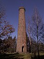
Lookout tower on the Great Wintersberg (Wasgauer Felsenland)

Rehberg with Asselstein (left) (Wasgauer Felsenland)

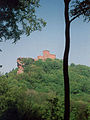
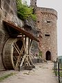
Schlossberg (Wegelnburg) (Wasgauer Felsenland)
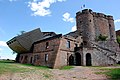
Schlossberg (Hohenburg) (Wasgauer Felsenland): View from the Wegelnburg

Hohe Derst (eastern Wasgau): View from the Stäffelsberg

Hohenberg (eastern Wasgau): View from the Rehberg

Mohnenberg (eastern Wasgau): View from Schöneck Castle
Föhrlenberg (eastern Wasgau): View from the Rehberg

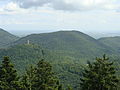
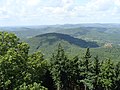
View from Rehberg towards Treutelsberg (eastern Wasgau)
Sonnenberg with Trifels (Wasgauer Felsenland)
Rothenberg with Madenburg (eastern Wasgau)
Ebersberg (Wasgauer Felsenland): View from the Rehberg

View from Sankt Johann bei Zabern to Michaelsberg (southern Wasgau)


.JPG)
.JPG)


geology
Formation and storage of the rock layers

As part of the Palatinate Forest and the Northern Vosges, the Wasgau is shaped by layers of Buntsandstein and, to a lesser extent, the Zechstein , predominantly in the late Permian (256-251 million years ago) and at the beginning of the Triassic (251-243 million years ago) desert-like climatic conditions . It emerged sedimentary sequences with a thickness of about 500 meters, which have a different strength, density and coloring and strong from often solidified, pebbly bound medium- and coarse-grained sandstones , but also partly of fine-grained sandstones with argillaceous bond and shales exist. Divided these rocks are in different layers , wherein in the region of red sandstone between the lower , middle and upper red sandstone is discriminated.
These rock layers underwent tectonically induced rearrangements in the palaeogene (65–23.8 million years ago) during the formation of the Upper Rhine Rift, which are of decisive importance for the current landscape of the Wasgau. The edges of the trench were raised and the layers of the red sandstone, and in some cases older rocks (Zechstein, Rotliegend ), were exposed after the overburden had been removed. There was inclination, bulging (displacement and bending) and breaking (formation of faults ) of the various rock layers.
Development of today's relief


Due to the saddle-trough structure of the mountains on the left bank of the Rhine running from southwest to northeast, these bulges were particularly pronounced in the northern and central parts of the Wasgau, i.e. in the area of the southern Palatinate saddle , so that the surface layers there were more heavily removed. Since the formations of the Zechstein, for example the Annweilerer and Speyerbach strata , tend to consist of finer-grain sandstones with a clayey bond and shale and therefore have a softer consistency, this material could be cleared out better and older rocks of the Zechstein and rocks of the Rotliegend could be exposed. As a result, leveling areas and wide valleys formed, as they are particularly characteristic of the northeastern Wasgau, for example near Gossersweiler and Völkersweiler , and also near Hauenstein , Busenberg or Fischbach near Dahn . At the same time, parts of the Lower Buntsandstein, the so-called Trifels and Rehberg layers, were preserved, as they largely consist of harder quartz sandstone and are therefore particularly resistant to weathering and erosion . The small-scale relief of the Wasgau developed through erosion in the Neogene (23.8 to 2.8 million years ago) and especially in the Quaternary (2.8-0.01 million years ago) , which is characterized by diverse, often conical and isolated Related mountain shapes with bizarre rock formations is characterized (Wasgau rock country) . This rock country extends from Annweiler in the northeast to about the Falkensteiner Bach near Philippsburg in the southwest and forms the actual core area of the Wasgau.

If the rock layers were undisturbed, the typical landscape structure of the rock country would end shortly after Annweiler due to their inclination. However, tectonic processes led to shifts and displacements of the individual rock layers, so that west of the Elmsteiner fault, for example from Wilgartswiesen , Spirkelbach , Schwanheim , Erlenbach , Niederschlettenbach to Lembach in Alsace, the rock-forming Trifels layers were lifted by around 80 to 100 meters and therefore in the Dahner and Schönauer Felsenland continue to shape the surface structure. Only west of (Wies-) Lauter and Sauer or Saarbach do these rocks finally submerge under the younger layers of the Middle Buntsandstein, for example under the Karlstal layers , so that the landscape of the western Wasgau is more like that of the Middle Palatinate Forest. This also applies to the southern part of the Wasgau, as the various rock formations in the area of the Zaberner Steige and the Pfalzburger Mulde are less bulky and therefore their cover layers have not been eroded as much. For this reason, younger rocks of the Middle and Upper Buntsandstein form the surface of the mountain, while the Rehberg and Trifels layers are only exposed in deeply incised valleys. In addition, south of a line from Ingweiler - Wingen ad Moder - Diemeringen, the main distribution area of the Buntsandstein from the eastern edge of the ditch to the rocks of the Lower Muschelkalk in the west is narrowed from around 15 to a minimum of 7 kilometers in the area of the Zaberner Steige (see map above).
Name and story
Wasgau and Vosges have the same linguistic origin, the initially Celtic mountain and forest god Vosegus , who was adopted by the Romans in the Latin terms Vosegus mons (Vosegus mountains) and Silva Vosegus (Vosegus forest) . This name was in French to Vosges , in Middle High German to Wasigen which to Wasgau and Wasgenwald continuously developed. The Vôge , which adjoins the Vosges to the south-west, is also linguistically related , the name of which is derived from a feminine * Vosagia.
Gradually the names diverged because of the German-French border - the Alsatian-Lorraine part of the mountains is now called the Vosges , the Palatinate Wasgau . During the period from 1871 to 1919, when Alsace and parts of Lorraine were temporarily part of Germany again, the Vosges were mostly referred to as Wasgenwald in order to emphasize the distance from the Romance-Latin term.
Within the framework of European unification ( Schengen Agreement ), however, there are also opposing tendencies: Both parts of the mountains are understood across borders as a natural spatial and cultural-historical unit and, in addition to the use of the official landscape names "Vosges du Nord" and "Southern Palatinate Forest", with the overarching term " Wasgau ”or“ Vasgovie ”; Thus, according to the historical development of the name, this designation is used not only for the Palatinate, but also for the Alsatian-Lorraine part of the landscape.
The so-called southern route of the historic Palatinate Way of St. James once led through the Wasgau , which today is of more tourist than religious importance.
Attractions
Castles

Trifels

Berwartstein

Drachenfels
Altdahn

View from Hohenburg to Fleckenstein
Lichtenberg


Some of the numerous castles in the area have made history: In the Trifels Imperial Castle , which was partially restored during the 20th century, imperial regalia were temporarily kept in the Middle Ages ; Together with the castles Anebos and Scharfenberg , the Trifels is the landmark of Annweiler. The Berwartstein of the legendary knight Hans von Trotha , called “Hans Trapp”, has been restored, inhabited and managed. The Drachenfels Castle was destroyed because a proportion of the rebellious knight Franz von Sickingen had heard. Other castles in the region are z. B. (from north to south):
- Lviv
- Neudahn
- Madenburg
- Dahner Burgengruppe , consisting of Altdahn, Grafendahn and Tanstein
- Landeck
- Lindelbrunn
- Wegelnburg , Hohenburg and Löwenstein
- Fleckenstein
- Flower stone
- Wasigenstein
- Falkenstein
- Wasenburg
- Lichtenberg
- Hueneburg
Rock formations
to form


The Wasgauer Felsenland is rich in bizarre sandstone cliffs, which have arisen over the course of millions of years through weathering and erosion of the differently solidified layers of rock of the lower and middle red sandstone (see section Geology ); In the Palatinate part of the Wasgau alone, there are over 200 rock massifs and free-standing rock towers. Depending on the erosion of the Trifels, Rehberg and Karlstal strata, a distinction is made between rock reefs (e.g. Heiden and Buhlstein pillars near Busenberg ; Lämmerfelsen near Dahn ), rock walls (e.g. Asselstein near Annweiler; pea rocks near Egelshardt) and rock walls (e.g. B. Dimberg near Dimbach ). Other rock shapes are rock towers (e.g. Hundsfelsen near Waldrohrbach ; Hühnerstein near Hauenstein ) and rock blocks (e.g. Lindelbrunn near Vorderweidenthal ; Fleckenstein near Hirschthal or Lembach ), which are often found on Kegelbergs.
Rock openings, peat rocks (e.g. Eilöchelfelsen near Busenberg ), crevices (e.g. bride and groom near Dahn) and table rocks (e.g. Teufelstisch near Hinterweidenthal ) resulted from small-scale weathering of narrow layers of different hardness . On many rocks - for example on the almost two kilometer long rocky reef of the Altschlossfelsen near Eppenbrunn - you can also see cornice-like overhangs and weathered honeycombs.
Many castles in Wasgau were also built on rocky reefs and blocks; Particularly prominent examples of this are the castles of the “Burgdrefaltigkeit” Trifels, Anebos and Scharfenberg near Annweiler and the Lindelbrunn Castle a few kilometers to the southwest. Well-known rock castles are also the Berwartstein near Erlenbach , the Drachenfels near Busenberg and the Fleckenstein near Hirschthal or Lembach (see section Castles ).
fauna and Flora
From a botanical point of view, many rocky regions form biotopes of particularly resistant and undemanding sandstone vegetation , which is mainly composed of stunted pines , heather and simple grasses (e.g. wiry Schmiele ), in more humid places also mosses and ferns . In addition, peregrine falcons have resettled on a number of rocks since the 1980s , so that considerable restrictions have become necessary for climbers, hikers and other users. In order to avoid conflicts of use, these regulations (restricted list and guarding of the breeding rocks) are jointly established annually by the Palatinate Climbers Association and the Palatinate nature conservation associations (e.g. the NABU's "Peregrine Falcon Protection" working group).
Sport climbing and hiking
The Wasgauer Felsenland offers the sport climber a variety of different possibilities, whereby the texture and weathering of the sandstone differ greatly and can therefore lead to very different degrees of difficulty. Well-known climbing areas include the regions around Annweiler (e.g. Asselstein), Lug (e.g. Luger Friedrich ) and Hauenstein (e.g. Spirkelbacher Rauhfels ), as well as the Dahner (e.g. Lämmerfelsen ) and Erfweiler area (e.g. Hegerturm ), which also includes the well-known Bärenbrunner Valley (e.g. pen-field rock) .
In order to bring this rocky landscape closer to hikers, a number of themed hiking trails have been set up in recent years , of which the Dahner Felsenpfad , the Busenberger Holzschuhpfad , the Hauensteiner Schusterpfad and the Annweilerer Buntsandsteinpfad should be mentioned as examples. While most of the rocks are reserved for experienced climbers, certain rock reefs can also be hiked (e.g. Buhlsteine , Heidenpfeiler and Rötzenstein ) or climbed with the help of climbing systems with appropriate caution (e.g. Hühnerstein near Hauenstein).
Others
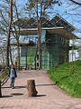
Biosphere house

Treetop Walk

German Shoe Museum

Shoe Museum: Shoe size 180

Administrative center of the Northern Vosges Regional Nature Park

Rock apartments in Graufthal


.JPG)
.jpg)
Other sights include the biosphere house with the connected treetop path in Fischbach , the wildlife and hiking park Südliche Weinstrasse in Silz , the German shoe museum and the glass shoe factory in Hauenstein as well as the administrative center of the regional nature park Northern Vosges in La Petite-Pierre (German: Lützelstein ) , which contains an exhibition on the Palatinate Forest-Northern Vosges Biosphere Reserve. In addition, La Petite-Pierre houses the Alsatian Seal Museum (Musée du sceau alsacien) and a local museum (Musée des Arts et Traditions populaires) .
Another attraction are the rock apartments located a few kilometers south of Lützelstein in Graufthal ; For centuries, up to 37 residents lived in three houses built into a rock face. After the last resident died in 1958, the rock houses were preserved as cultural monuments and can now be visited as an open-air museum.
Economy and Infrastructure
Settlement

Around 237,000 inhabitants live in the entire area of the Palatinate Forest-Northern Vosges Biosphere Reserve, spread over 215 communities. With a total area of 3,105 km², this corresponds to a population density of slightly more than 76 inhabitants per km², with 89 inhabitants per km² in the German and 59 inhabitants per km² in the French. In addition to the actual forest mountains, the biosphere reserve also includes more densely populated areas on the edge of the Rhine rift valley and in the area of the Westrich plateau. If one excludes these areas and limits oneself to the area of the actual natural area, one obtains extremely low values for Central European conditions with 20–30 inhabitants per km² (e.g. 24 inhabitants per km² near Philippsburg in the canton Bitsch); In comparison, the population density for the whole of Germany is 229 people per km². Correspondingly, depending on the natural demarcation, the number of its communities for the German part of the Wasgau is reduced to around 50 and for the French part to around 40, i.e. a total of around 90 communities. The relatively small villages only take up 5 percent of the total area, are surrounded by extensive, deserted forests (70–90% of the total area) and are mainly located in valleys and on flat areas in the low mountain range. Exceptions are hilltop villages such as Climbach in the high forest to the east, Lemberg in the Palatinate and Lorraine, as well as the tourist community of Lützelstein in the south-west ; The latter are located in the plateau-like transition area between the red sandstone relief of the Wasgau and the limestone formations of the Westrich plateau.
Other larger communities on the German side are Annweiler am Trifels , Dahn and Hauenstein , on the French side, in addition to the above-mentioned localities, Lembach , Ober- and Niedersteinbach and Wingen ad Moder . On the eastern edge of the mountains you can find Albersweiler and Bad Bergzabern in the Palatinate, and Weißenburg, Bad Niederbronn, Ingweiler (French: Ingwiller ) and Zabern in Alsace . In the south-west to north-west edge of the Wasgau are Pfalzburg and Bitsch in Lorraine, Eppenbrunn in the Palatinate and Pirmasens, the largest community in the Wasgau.
economy

The formerly important iron production and processing (e.g. iron smelting in Schönau ) was discontinued towards the end of the 19th century. Various Gienanth fountains are evidence of this tradition to this day.
In the 19th and 20th centuries, in addition to forestry, there were also small factories and small factories that mainly dealt with shoe manufacturing.
After the Second World War and with the decline of the shoe industry, the economy increasingly turned to tourism , which has now become the main branch of business. The tourist infrastructure is largely fragmented, the large-scale project of a Wasgau lake near Fischbach, which was operated from 1967 to 1987, could not be implemented against the resistance of the population and the nature conservation associations. In addition to mere relaxation, active holidays are also offered, e.g. B. Sport climbing in the climbing area Südpfalz or hiking . Several well-developed cycle paths mainly follow the valleys in Wasgau.
traffic

In addition to the B 10 main artery on the northern edge, the B 48 Annweiler– Bad Bergzabern in the east and the B 427 Hinterweidenthal –Dahn – Bad Bergzabern in the west and south open up the region on the Palatinate side. On the other side of the border, the well-developed Departementstrasse 662 (D 662) connects Bitsch, which is on the western edge of the Wasgau, with Bad Niederbronn and Hagenau (French: Haguenau ) in the Rhine plain. In the very south of the natural area, the Autobahn 4 (A4) from Paris to Strasbourg (French: Strasbourg ) and Departementstrasse 604 (D 604) cross the Zaberner Steige.
The Landau – Rohrbach railway line running parallel to the B 10 used to be part of the long-distance connection between Saarbrücken and Munich , but its importance has been increasingly downgraded. On Sundays and public holidays, excursion traffic takes place on the Wieslauterbahn in the west, including the Bundenthaler . The route from Saarbrücken via Saargemünd (French: Sarreguemines ) through the Moder valley to Strasbourg is mainly used for regional traffic. The high-speed rail link between Paris and Strasbourg is currently under construction, and will cross under the Zaberner Steige in a tunnel.
literature
- August Becker: The Palatinate and the Palatinate . 7th edition. Pfälzische Verlagsanstalt, Landau / Pfalz 2005, ISBN 3-89857-193-9 , p. 200-337 (1st edition 1857).
- Rüdiger Bernges: rock castles in Wasgau . 4th edition. Warlich Verlag, Meckenheim 2005, ISBN 3-930376-25-3 .
- Michael Geiger u. a. (Ed.): The Palatinate Forest. Portrait of a landscape . Verlag Pfälzische Landeskunde, Landau / Pfalz 1987, ISBN 3-9801147-1-6 .
- Michael Geiger: The landscapes of the Palatinate . In: Michael Geiger (ed.): Geography of the Palatinate . Verlag Pfälzische Landeskunde, Landau / Pfalz 2010, ISBN 978-3-9812974-0-9 , p. 92-113 .
- Daniel Häberle: The Palatinate Forest. A contribution to the regional studies of the Rhine Palatinate . Georg Westermann Verlag, Braunschweig / Berlin 1913, p. 10-32 .
- Karl Heinz: Palatinate with Wine Route. Landscape, history, culture, art, folklore . Glock and Lutz Verlag, Heroldsberg 1976, p. 191-238 .
- Emil Heuser: New Palatinate Leader . 14th edition. Waldkirch Verlag, Ludwigshafen / Rhein 1979 (1st edition 1900).
- Emil Knöringer: The Wasgau with its rocks and rock castles . 2nd Edition. Publishing house Palatinate Art Dr. Hans Blinn, Landau / Pfalz 1985, ISBN 3-922580-16-5 .
- State Office for Geology and Mining Rhineland-Palatinate (Ed.): Geology and Earth History of Rhineland-Palatinate . Schweizerbart'sche Verlagbuchhandlung, Stuttgart 2005, ISBN 3-510-65265-7 .
- Kurt Reh: The Palatinate Forest. An introduction to landscape and naming . In: Michael Geiger u. a. (Ed.): Palatinate regional studies . Contributions to geography, biology, folklore and history. tape 1 . Self-published, Landau / Pfalz 1981, p. 381 .
- Heinz Wittner: Great Palatinate Leader . German hiking publisher Dr. Mair & Schnabel, Stuttgart 1981, ISBN 3-8134-0106-5 , pp. 176-226 .
Web links
- Palatinate Forest – Vosges du Nord biosphere reserve
- Biosphere house with treetop path
- Castle paradise Wasgau
- Wasgau hiking paradise
Individual evidence
- ^ Emil Knöringer: The Wasgau with its rocks and rock castles. 1985, p. 14.
- ^ Karl Heinz: Palatinate with Wine Route. 1976, pp. 197-199.
- ↑ a b c State Office for Surveying and Basic Geographic Information Rhineland-Palatinate (ed.): Topographic maps 1: 25,000 and 1: 50,000 , accessed on February 13, 2012.
- ↑ a b c Institut Géographique National (ed.): Cartes Topographiques 1: 25,000 and 1: 50,000 . Paris, different years.
- ↑ a b State Office for Geology and Mining Rhineland-Palatinate: Geological overview map of Rhineland-Palatinate , accessed on February 13, 2012.
- ↑ Adalbert Pemöller: Geographical land survey: The natural spatial units on sheet 160 Landau i. d. Palatinate. Federal Institute for Regional Studies, Bad Godesberg 1969. → Online map (PDF; 4.2 MB)
- ↑ Michael Geiger et al. (Ed.): The Palatinate Forest in a geographical overview. 1987, pp. 40-41.
- ↑ Heinz Wittner among others: Vogesen - North . German hiking publisher Dr. Mair & Schnabel & Co., Stuttgart 1983, p. 81.
- ↑ Michael Geiger: The Palatinate Forest in a geographical overview. In: Michael Geiger (Ed.): The Palatinate Forest. Portrait of a landscape. 1987, p. 41.
- ↑ Michael Geiger et al. (Ed.): The Palatinate Forest in a geographical overview. 1987, pp. 24-29.
- ↑ Jost Haneke, Michael Weidenfeller: The geological building units of the Palatinate. In: Michael Geiger u. a. (Ed.): Geography of the Palatinate. Publishing house Palatinate cultural studies, Landau / Pf. 2010, pp. 82-84.
- ^ BRGM: Geological map section Zaberner Steige and Northern Vosges . Retrieved March 9, 2012.
- ↑ Bernhard Maier : The Celts. Your story from the beginning to the present . CH Beck, Munich 2000, ISBN 3-406-46094-1 .
- ^ Karl Heinz: Palatinate with Wine Route. 1976, p. 198.
- ↑ Michael Geiger et al. (Ed.): The Palatinate Forest in a geographical overview. 1987, pp. 18-19.
- ↑ The rocks of the Palatinate Forest . Website of the hiking portal Pfalz. Retrieved March 12, 2012.
- ↑ Michael Geiger: The Palatinate Forest in a geographical overview. In: Michael Geiger (Ed.): The Palatinate Forest. Portrait of a landscape. 1987, pp. 39-43.
- ↑ Klaus Hünerfauth: An overview of the natural and cultural landscapes of the Palatinate. In: Michael Geiger (ed.): Geography of the Palatinate. Verlag Pfälzische Landeskunde, Landau 2010, p. 158.
- ↑ Naturschutzbund Deutschland e. V. (NABU) in Rhineland-Palatinate: Peregrine falcon protection Rhineland-Palatinate . Retrieved June 14, 2012.
- ↑ Thomas Striebig: On foot through the Vosges . GeoHist Verlag, Neu-Anspach 2000, p. 76.
- ↑ Palatinate Forest-Vosges du Nord Biosphere Reserve: The reserve in figures ( Memento from August 12, 2013 in the Internet Archive ). Retrieved March 6, 2012.
- ↑ Bernhard Köppen: Aspects to the population dynamics in the Palatinate. In: Michael Geiger (ed.): Geography of the Palatinate. Verlag Pfälzische Landeskunde, Landau 2010, p. 192 ff.
- ↑ Rhineland-Palatinate Ministry of Economic Affairs: Welcome to the Rhineland-Palatinate cycling region! .