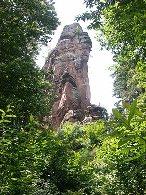
Asselstein
| Asselstein | ||
|---|---|---|
| height | 400 m above sea level NHN | |
| location | near Annweiler am Trifels ; District of Südliche Weinstrasse , Rhineland-Palatinate ( Germany ) | |
| Mountains | Palatinate Forest | |
| Coordinates | 49 ° 11 '17 " N , 7 ° 57' 36" E | |
|
|
||
| rock | Red sandstone | |
The Asselstein near Annweiler am Trifels in the Rhineland-Palatinate district of Südliche Weinstrasse is a little more than 400 m above sea level. NHN high elevation in the Palatinate Forest , on which the Asselstein rock tower is located.
Geographical location
The Asselstein is located in the eastern part of the Palatinate Forest about 1.7 km south of Annweiler am Trifels, 1 km west of its district Bindersbach and 1 km northeast of the Rehberg ( 576.8 m ). The road from Annweiler to Trifels, the Trifelsstraße ( Kreisstraße 2), leads over the southern high elevations of the Asselstein to the Rehberg north flank.
Asselstein rock tower
The rock reef, which is around 60 meters long and 10 meters wide, is 58 meters high at its highest point and consists of the rocks of the lower red sandstone ( trifle layers ). The Asselstein was first climbed in June 1860. It belongs with its almost 80 routes, e.g. B. Normalweg IV-, Westwand V-, Rolfkamin V + and Ostwand V (all UIAA scale ) to the larger climbing destinations in the climbing area Südpfalz . The hardest route is rated 9+ (UIAA). Not far east of the rock is the Asselstein climbing hut .
Individual evidence
- ↑ a b Map service of the landscape information system of the Rhineland-Palatinate Nature Conservation Administration (LANIS map) ( notes )
Web links
- "Rock 38: Asselstein. The mother of all Palatine rock ships"
- Asselstein (photo)
- Website climbing hut on the Asselstein
- Gallery of some meaningful pages from the total of 24 archived summit books of the Asselstein until 2019. Presented on the website of the Association of Palatinate Climbers. Retrieved August 20, 2019

