
Sarreguemines
|
Sarreguemines Saargemünd |
||
|---|---|---|

|
|
|
| region | Grand Est | |
| Department | Moselle | |
| Arrondissement | Sarreguemines | |
| Canton | Sarreguemines ( chief lieu ) | |
| Community association | Sarreguemines Confluences | |
| Coordinates | 49 ° 7 ' N , 7 ° 4' E | |
| height | 192-293 m | |
| surface | 29.67 km 2 | |
| Residents | 20,783 (January 1, 2017) | |
| Population density | 700 inhabitants / km 2 | |
| Post Code | 57200 | |
| INSEE code | 57631 | |
| Website | http://www.sarreguemines.fr/de | |

Saargemünd ( , French Sarreguemines , Platt Saargemìnn , ) is a French city with 20,783 inhabitants (as of January 1, 2017) in the Moselle department in the French region of Grand Est (until 2015 Lorraine ). The city is the seat of the sub-prefecture ( Arrondissement Sarreguemines ) and the capital of the canton of Sarreguemines . The inhabitants call themselves Sarregueminois ( Saagemìnner in the local Rhine-Franconian dialect ; German Saargemünder ).
geography

Sarreguemines is located in northeast France, directly on the border with the German state of Saarland , at 222 m above sea level. NHN. In Sarreguemines which opens Assemblies in the Saar , which over the Saar canal to the Rhine-Marne Canal ( Canal de la Marne au Rhin is connected).
The districts of Neunkirchen , Wölferdingen (both incorporated in 1964) and Folpersweiler, which was incorporated in 1971, belong to Saargemünd .
Neighboring communities of Saargemünd are Kleinblittersdorf in the north, Bliesgersweiler and Frauenberg in the northeast, Bliesebersingen in the east, Saareinsmingen in the southeast, Remelfingen and Neuscheuern in the south, Hambach and Wustweiler in the southwest, Iplingen in the west and Ruhlingen and Großblittersdorf in the northwest.
origin of the name
The name is derived from the German word Gemund ( Latinised gemundia in old documents ) and refers to the confluence of the Saar and Blies within the urban area.
Old names are Gumunde (1237), Gemindt / Gemündt (1380), Gemüde (1471), Sargemünt (1577), Saargemünde (1592), Sar-gemünd (1636), Gemünd an der Sar (1645), Sargueminde (1661), Zargueminde (1698).
history
The place was first mentioned in 706 as Gaimundas , then in 1577 for the first time with the addition of the Saar ( Sargemünt ). A name form Frenchized to Guemunde appeared in 1594. From 1679 to 1697 Sarreguemines were already under French occupation before it came to France for 105 years in 1766.
In 1861 Saargemünd had 6,075 inhabitants. From 1871 to 1919, Sarreguemines belonged to the German Empire as part of the realm of Alsace-Lorraine . The city was the administrative seat of the Saargemünd district . Around 1900 Saargemünd had a Protestant and a Catholic church, a synagogue , a grammar school with secondary school classes , an agricultural winter school, a former Capuchin monastery , a chief forestry , shipping , a main tax office and was the seat of a regional court .
French between 1919 and 1940, it was occupied by German troops early in World War II and annexed by Nazi Germany from 1940 ( CdZ area of Lorraine ). At the beginning of December 1944, Sarreguemines were captured by American troops and have since returned to France.


Demographics
| year | population | Remarks |
|---|---|---|
| 1871 | 6863 | in 577 buildings, including 685 Protestants , six Mennonites and 364 Israelites |
| 1872 | 6802 | |
| 1890 | 13,076 | |
| 1905 | 14,932 | with the garrison (four squadrons Bavarian Chevaulegers No. 5, a Bavarian infantry regiment No. 23); mostly Catholic residents, according to other information, 14,919 residents |
| 1910 | 15,384 |
| year | 1962 | 1968 | 1975 | 1982 | 1990 | 1999 | 2007 | 2017 |
| Residents | 17,866 | 24,846 | 25,684 | 24,763 | 23,117 | 23.202 | 21,835 | 20,783 |
Attractions
The city is known for its once flourishing ceramic production . The production facility of the old Faïencerie (earthenware factory), located around the former “Wackenmühle” on the Blies, has been converted into a museum and can be visited, as well as the France and Wolfgang Kermer donation with works by around one hundred French ceramists from 1970-2000. After its restructuring, the garden laid out in the former factory area was included in the ensemble of Gardens without Borders in the greater SaarLorLux region . Significant buildings date from the Art Nouveau era in particular . The casino on the banks of the Saar is a special attraction . This building is a structure that was built for the workers of the Faïencerie. It contains a hall for cultural events and a restaurant. The facade is adorned with ceramic pictures.
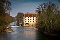
Saargemünd, Bliesmühle Ceramics Museum

Saargemünd, Bliesmühle Ceramics Museum
Saargemünd, Bliesmühle Ceramics Museum

Saargemünd, Bliesmühle Ceramics Museum

Saargemünd, Bliesmühle Ceramics Museum


Culture
The city has a rich cultural offer.
- The dialect festival “Mir redde platt” has been held annually for a decade. It serves to preserve the regional ( German ) Lorraine dialect , which has its roots in Rhine-Franconian . The festival extends over several weeks and combines the fields of art, culture and science in a rich program of events.
- An antique ceramics fair takes place in March each year. It is organized with a view to the city's long ceramic tradition, which was one of the leading ceramic manufacturers in Europe in the 20th century. Offered arts and crafts items such as earthenware , porcelain , stoneware , enamel , terracotta and majolica .
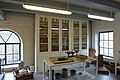
- Next to the town hall is a ceramic museum, the original winter garden of which is equipped with artistically valuable ceramic walls. In addition to a permanent exhibition of ceramic objects, there are regular changing exhibitions.
- At the end of June each year, the Saint Paul Festival takes place over a period of a few days throughout the city center . The main point of the festival is a traditional market, where regional products of all kinds are offered. Another focus is the “Street Theater Festival”, which is part of the St. Paul Festival and is now one of the most popular festivals of its kind in eastern France.
- The Vélo SaarMoselle takes place on an August weekend , an event that combines cycling with cultural experiences and culinary delights. Cultural events as well as culinary specialties of the region are offered at numerous locations on a day circuit, which also leads across the border into neighboring Saarland.
- For several years now, the city has had a media library in which cultural events such as the above-mentioned “Mir redde platt” festival take place.

Palace of Justice

City life

Sarreguemines railway station

Villa Utzschneider (1906)

Ceramic museum, Villa Geiger, winter garden


economy
In Saargemünd, a large tire plant of Continental AG and the packaging manufacturer Essentra are located.
traffic
Road traffic
The city is connected to the A4 (Paris-Strasbourg) car route running south via the N 61 and to the A320 car route and the 6 and 620 federal highways via the federal highway 51 and the N61 .
Rail transport

Until 1945, the city was connected to the Mannheim – Saarbrücken railway via the Bliestalbahn via Blieskastel to Homburg . Passenger traffic was not resumed after the war. Until 1954, the SNCF operated the line to Bliesbruck . Today trains run on the routes in the direction of Bitche (the extension via Niederbronn-les-Bains to Hagenau has now been discontinued), Sarre-Union , Metz , Strasbourg and Saarbrücken . The Saarbahn has existed since 1997 , which connects Saargemünd directly with the Saarbrücken city center and other Saarland municipalities via the Saarbrücken – Saargemünd railway line . The trains run every 30 minutes during peak times.
→ For the history of the station and its routes, see Saargemünd station
Bike paths
Saargemünd is the hub of various long-distance cycle routes . To the south the cycle path leads along the former towpath along the Saar Canal to the Rhine-Marne Canal . To the north, the cycle path accompanies the Saar to where it flows into the Moselle near Konz . To the east, the Glan-Blies cycle path leads along Blies and Glan to Staudernheim an der Nahe .
Town twinning
Personalities
- Jean-Pierre Bachasson de Montalivet (1766–1823), Minister of the Interior under Napoléon Bonaparte
- Jakob Christian Schmeltzer (1770–1864), German civil servant, District Administrator of Saarlouis
- Camille Crémer (1840–1876), French general
- Eberhard Hanfstaengl (1886–1973), German art historian
- Henri Bacher (1890–1934), painter and graphic artist
- Georg Eißer (1898–1964), German Assyriologist
- Toni Huppertz (1900–1945), German screenwriter and director
- Marianne Oswald (1901–1985), German-French singer
- Jean-Marie Rausch (* 1929), French politician, mayor of Metz
- Roland Minnerath (* 1946), Archbishop of Dijon since 2004
- Moreno Winterstein (* 1963), French jazz guitarist
- Charles Haffner (* 1976), French football player
- Mayo Hubert (* 1977), French jazz guitarist
- Eric Hassli (* 1981), French football player
- Matthieu Sprick (* 1981), French racing cyclist
literature
- Ewald Crusius: The changes in population density in the Lorraine districts of Forbach and Saargemünd 1801-1910. Metz 1913.
- Marianne Haas-Heckel: caretaker book for Saageminner Platt. Lexique du dialecte de la région de Sarreguemines. Bordeaux 2001.
Web links
- Homepage of Saargemünd
- Sarreguemines Museum
- Media library (German version) ( Memento from October 6, 2008 in the Internet Archive )
Individual evidence
- ↑ Dictionnaire topographique de l'ancien département de la Moselle - Ernest de Bouteiller (written 1868)
- ↑ a b c d M. Rademacher: German administrative history from the unification of the empire in 1871 to the reunification in 1990. (Online material for the dissertation, Osnabrück 2006)
- ↑ : Program of the college of Saargemünd for the school year 1872–1873 ( e-copy )
- ↑ a b Meyer's Large Conversation Lexicon . 6th edition, Volume 17, Leipzig / Vienna 1909, p. 351, ( online );
- ^ Georg Lang: The government district of Lorraine. Statistical-topographical manual, administrative schematic and address book , Metz 1874, p. 141 ( online ).
- ^ Complete geographic-topographical-statistical local lexicon of Alsace-Lorraine. Contains: the cities, towns, villages, castles, communities, hamlets, mines and steel works, farms, mills, ruins, mineral springs, etc. with details of the geographical location, factory, industrial and other commercial activity, the post, railway u. Telegraph stations and the like historical notes etc. Adapted from official sources by H. Rudolph. Louis Zander, Leipzig 1872, Sp. 53 ( online )
- ^ Céramique française 1970–2000: Donation France et Wolfgang Kermer. Sarreguemines: Editions Musées de Sarreguemines, 2018, ISBN 978-2-91375-924-4