
Nahe (Rhine)
| Near | ||
 The catchment area of the Nahe and their tributaries |
||
| Data | ||
| Water code | EN : 254 | |
| location | Germany | |
| River system | Rhine | |
| Drain over | Rhine → North Sea | |
| source | near Selbach (Nohfelden) 49 ° 32 ′ 27 ″ N , 7 ° 1 ′ 33 ″ E |
|
| Source height | 459 m above sea level NHN | |
| muzzle | in Bingen at river kilometer 529.1 from left in the Rhine Coordinates: 49 ° 58 '12 " N , 7 ° 53' 19" E 49 ° 58 '12 " N , 7 ° 53' 19" E |
|
| Mouth height | 79 m above sea level NHN | |
| Height difference | 380 m | |
| Bottom slope | 3 ‰ | |
| length | 125.1 km | |
| Catchment area | 4,067,068 km² | |
| Discharge at the Grolsheim A Eo gauge : 4013 km² Location: 7.4 km above the mouth |
NNQ (August 8, 1986) MNQ MQ Mq MHQ HHQ (December 21, 1993) |
1.62 m³ / s 4.48 m³ / s 29.2 m³ / s 7.3 l / (s km²) 342 m³ / s 917 m³ / s |
| Discharge at the mouth of the A Eo : 4067 km² |
MQ Mq |
29.5 m³ / s 7.3 l / (s km²) |
| Left tributaries | Traunbach , Schwollbach , Idarbach , Fischbach , Hahnenbach , Simmerbach / Kellenbach , Ellerbach , Guldenbach | |
| Right tributaries | Heimbach , Glan , Alsenz , Appelbach , Wiesbach | |
| Reservoirs flowed through | Kammerwoog , Niederhausen reservoir | |
| Medium-sized cities | Idar-Oberstein , Bad Kreuznach , Bingen | |
| Small towns | Kirn , Bad Sobernheim , Bad Munster am Stein-Ebernburg | |
 The Nahe spring near Selbach in the municipality of Nohfelden |
||
 Nahe bridge in Bad Kreuznach |
||
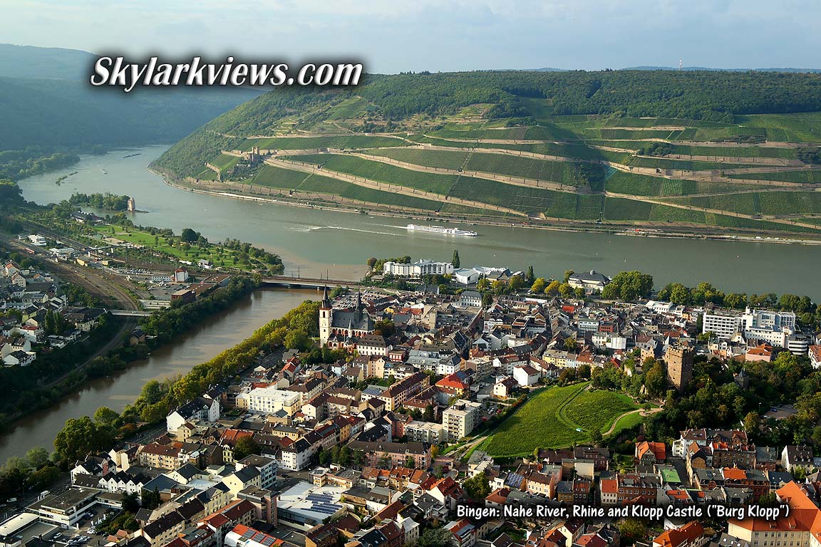
 View from Rüdesheimer Berg to the confluence of the Nahe with the Rhine with a bridge for rail and road traffic on the left bank of the Rhine ; on the left the old town of Bingen am Rochusberg , on the right the district of Bingerbrück and behind the medieval Drususbrücke |
||
The Nahe ( Latin Nava , originally Celtic Wild River ) is an approximately 125 km long left tributary of the Rhine in Saarland and Rhineland-Palatinate .
geography
course


The Nahe divides the low mountain range of the North Palatinate Bergland and Hunsrück as well as the natural areas Saar-Nahe-Bergland and Hunsrück. It flows through the Saarland district of St. Wendel and the Rhineland-Palatinate districts of Birkenfeld , Bad Kreuznach and Mainz-Bingen .
The river has its source in the Saarland in the Primstaler Heights natural area on the southern slope of the 505 m high Eckersberg . The source is located northwest of Selbach on the edge of the forest. Initially, the Nahe flows through two Nohfelden districts, initially Selbach and below Gonnesweiler . There it receives an inflow via the Bos from the Bostalsee reservoir , which it passes in the southeast. After flowing through the main town of Nohfelden, it leaves the Saarland in a north-easterly direction and crosses the border with Rhineland-Palatinate.
The course of the river continues in this direction through Hoppstädten-Weiersbach to Idar-Oberstein . In 1985, in the Oberstein district, the Nahe was built over a length of 1875 m with the Nahe High Road in order to relieve the old town of the through traffic of the federal road 41 . Down the river follow the towns of Kirn , Monzingen , Bad Sobernheim and Niederhausen as well as Bad Münster am Stein , Bad Kreuznach and Gensingen .
Finally, the Near happened - well north flowing - the Rochusberg and arrives at Bingen am Rhein , where she at Rheinknie from the south at Rhine kilometer 529.1 of the Rhine flows . The Nahe has an average water flow of 30 m³ / s here. The Nahe estuary is considered the border between the Upper and Middle Rhine .
Catchment area
The catchment area of the Nahe covers an area of 4065 km². It is drained over the Rhine to the North Sea
Because of this large catchment area in comparison to the length of the river, very strong floods can occur in the middle and lower reaches within a few hours , but they also drain away quickly. This can lead to discharge rates of over 1000 m³ / s in Bad Kreuznach and over 1300 m³ / s at the mouth.
The extent of the catchment area is shown on the map. Its boundaries are clockwise, starting in the east:
- the Rheinhessen Switzerland as a watershed to the Rhine
- the Donnersberg massif as a watershed between the Selz and Rhine
- the North Palatinate Uplands as a watershed to the Pfrimm and Rhine to the east and to Wallhalb and Schwarzbach to the south
- the Hunsrück as a watershed to the Prims , Blies and Saar to the south and to the Moselle to the northwest
- the Binger forest as a watershed to the Rhine to the north
Tributaries
- The length of the tributaries is greater than 10 km

The tributaries on the left are shown in dark, the ones on the right in light blue.
- The catchment area larger than 25 km²

The tributaries on the left are shown in dark, the ones on the right in light blue.
Sortable table
Most of the tributaries of the Nahe are listed in the following table. The orographic position of the mouth, the length including the source rivers, the catchment area , the altitude of the mouth and the water body number are given .
| Surname |
location |
Length in km |
EZG in km² |
muzzle |
Natural space |
GKZ |
comment |
|
|---|---|---|---|---|---|---|---|---|
| Height in m. ü. NHN |
place |
|||||||
| Oberthaler Bruchbach | right | 0.9 | approx. 2.5 km east of Selbach | Leißberg | in Saarland | |||
| Neunkircher Bach | Left | 3.5 | 3,944 | 389 |
Theley- Selbacher Hochmulde Leißberg |
254-1112 | ||
|
Leißbach brook from the Silzwald |
right | 2.4 | 3 | at Nohfelden-Elzenberger Mühle | Leißberg | 254-1114 | ||
| Enkersbruchbach | Left | 0.3 | north of the Elzenberger mill | 254-1115? | ||||
| Kochlands-Weiher-Bach | Left | 0.9 | 254-1115? | |||||
| Buckhorn | right | 0.8 | 254-1115? | |||||
| Schossberggraben | right | 0.6 | at Nohfelden- Gonnesweiler | 254-1115? | ||||
| Bos | Left | 5.8 | 12.634 | 379 | in Nohfelden-Gonnesweiler | 254-1116 | ||
| Gonnesweiler Dörrenbach | Left | 1.1 | northeast of Nohfelden- Gonnesweiler | 254-1117? | ||||
| Walhausen brook | right | 4.3 | 7.775 | 366 | opposite Nohfelden- Türkismühle |
Hirsteiner Bergland Nohfelder Kuppenland |
254-1118 | |
| Söterbach | Left | 9.8 | 31,452 | 365 | in turquoise mill |
Prims-Traun-Senke Söterner Mulde Nohfelder Kuppenland |
254-112 | |
| Kappbach | Left | 4.2 | 3.407 | 358 | 254-1132 | |||
| Pedelsbach | right | 1.544 | ||||||
| Moat | right | 0.7 | in Nohfelden | 254-113? | ||||
| Freisbach | right | 12.9 | 43,369 | 350 | in Nohfelden | 254-114 | ||
| Kellerbach | Left | 2.811 | 3,922 | 344 | 254-1152 | in Rhineland-Palatinate | ||
| Neubrücker Mühlbach | Left | 0.443 | 0.134 | 337 | at Ellweiler -Neubrücker Mühle | 254-1154 | Origin: tee from Traunbach | |
| Traunbach | Left | 19,183 | 64.671 | 335 | at Ellweiler-Neubrücker Mühle | 254-116 | ||
| Obels river / Rohwies raft | right | 1,348 | 2,441 | 332 | 254-1172 | |||
| Bach from the Weisenberg | right | 1.515 | 0.898 | 331 | 254-11792 | |||
| Steinaubach | Left | 10,471 | 26.092 | 330 | to Hoppstädten-Weiersbach - Neubrücke | 254-118 | ||
| Hoppstädter Bach | Left | 0.855 | 1.353 | 328 | 254-11912 | |||
| Weiersbach | right | 2.171 | 2.306 | 327 | 254-119192 | |||
| Staffelbach | Left | 5.292 | 10,439 | 326 | to Hoppstädten-Weiersbach-Hoppstädten | 254-1192 | ||
| Mühlenbach | Left | 1.162 | 1.040 | 325 | 254-11992 | |||
| Bach at the Mausemühle | right | 0.899 | 0.394 | 322 | 254-11994 | |||
| Bach at the Stone Man | right | 1,833 | 1.666 | 322 | 254-11996 | |||
| Heimbach with upper course Reichenbach | right | 10,451 | 74.136 | 317 | in front of Heimbach -Bahnhof Heimbach (Nahe) | 254-12 | ||
| NN | Left | 0.860 | 1.678 | 300 | Nohen / Hoppstädten border | 254-132 | ||
| Little Hohlbach | right | 0.473 | 0.332 | 298 | towards Nohen | 254-1332 | ||
| Nohen Bach | Left | 0.569 | 0.333 | 298 | in Nohen | 254-1334 | ||
| Hohlbach | right | 1.065 | 0.779 | 298 | towards Nohen | 254-1336 | ||
| Röhmbach | Left | 2,615 | 2.765 | 297 | in Nohen | 254-134 | ||
| Kippbach / Odelsgraben | Left | 1.216 | 1.147 | 290 | 254-13912 | |||
| Pressure wood trench | Left | 0.325 | 289 | 254-13919a | ||||
| Reilsbach / Landsgraben | right | 1.353 | 1.807 | 288 | at Nohen | 254-1392 | ||
| Brook from the lock head / lock ditch | right | 0.772 | 0.636 | 284 | at Kronweiler | 254-1394 | ||
| Schwollbach | Left | 14,451 | 66.194 | 283 | in Kronweiler | 254-14 | ||
| Reibertsbach | right | 1.575 | 1.282 | 281 | Frauenberg / Reichenbach border | 254-1512 | ||
| Ellenbach | right | 3.823 | 4,670 | 277 | north of the ruins of Frauenburg | 254-152 | ||
| Frauenberger Bach / Selbach | right | 1.415 | 0.873 | 273 | near Frauenberg | 254-15312 | ||
| Waldbach | right | 0.563 | 0.249 | 273 | to Frauenberg | 254-153192 | ||
| Schachersgraben | Left | 0.877 | 271 | Length: own measurement | ||||
| Klausgraben | right | 1.122 | 1.032 | 269 | 254-1532 | |||
| Devil's Trench | Left | 0.767 | 0.604 | 269 | 254-1534 | |||
| Lambach | Left | 2.167 | 2,671 | 267 | across from Idar-Oberstein- Hammerstein | 254-154 | ||
| Siesbach | Left | 11,348 | 24.825 | 263 | on the municipality boundary from Oberbrombach to Idar-Oberstein- Enzweiler | 254-156 | ||
| Hasbach | right | 0.846 | 0.662 | 249 | before Idar-Oberstein | 254-1592 | ||
| Idarbach | Left | 21,516 | 93.665 | 252 | in central Idar-Oberstein | 254-16 | Estuary built over by the B41 | |
| Wüstlautenbach | right | 4,542 | 4,296 | 252 | in central Idar-Oberstein | 254-172 | Estuary built over by the B41 | |
| Schönlauterbach | right | 6.165 | 10,028 | 247 | in central Idar-Oberstein | 254-174 | Estuary built over by the B41 | |
| Seitzenbach | Left | 1.498 | 0.735 | 247 | 254-1751112 | Estuary built over by the B41 | ||
| Fallbach | right | 0.373 | 0.862 | 237 | 254-1751192 | |||
| Kleintiefenbach | right | 0.753 | 0.687 | 234 | 254-17512 | |||
| Großtiefenbach | right | 3.356 | 3.124 | 233 | between central Idar-Oberstein and Idar-Oberstein- Nahbollenbach | 254-1752 | ||
| Bollenbach | right | 7.594 | 15.614 | 225 | in Nahbollenbach | 254-176 | ||
| Ringelbach | Left | 3.227 | 3.791 | 224 | across from Nahbollenbach | 254-1792 | ||
| Heidengraben | Left | 0.983 | 0.298 | 221 | opposite Nahbollenbach | 254-17932 | ||
| Kesselgraben | Left | 0.542 | 0.518 | 215 | opposite Weierbach | 254-17934 | ||
| Schnorrenbach | right | 2.809 | 2.391 | 215 | in Weierbach | 254-1794 | ||
| Dickesbach | right | 4,515 | 5.648 | 209 | in Weierbach | 254-17992 | ||
| Fischbach | Left | 21,335 | 97.614 | 208 | in Fischbach | 254-18 | ||
| Reidenbach | right | 7,868 | 11,913 | 206 | at Idar-Oberstein-Niederreidenbacher Hof | 254-192 | ||
| Bärenbach | right | 11.875 | 20.780 | 200 | near Bärenbach | 254-194 | ||
| Rohrsbach | Left | 2.272 | 2,390 | 195 | near Kirnsulzbach | 254-1952 | ||
| Bärenbach | right | 1.079 | 0.620 | 194 | opposite Kirnsulzbach | 254-19592 | ||
| Grossbach | right | 15.192 | 41.848 | 189 | in Kirn -ölmühle Spielmann | 254-196 | ||
| Hahnenbach | Left | 37.964 | 268.273 | 184 | in the central Kirn | 254-2 | ||
| Heidegraben / Meckenbach | right | 4.825 | 7.431 | 179 | to Kirn | 254-32 | ||
| Itzbach | Left | 3.018 | 2.740 | 177 | 254-332 | |||
| Simmerbach | Left | 57.159 | 395,061 | 168 | at the Simmerhammer ( Simmertal ) | 254-4 | ||
| Aresbach | right | 3.222 | 2.557 | 162 | before Merxheim | 254-512 | ||
| Naugraben | right | 1.457 | 1.627 | 161 | north of Merxheim | 254-5132 | ||
| Etterbach | Left | 3.657 | 4.830 | 160 | opposite Merxheim | 254-514 | ||
| Albach | right | 5.503 | 8.213 | 160 | north of Merxheim | 254-516 | ||
| Gaulsbach | Left | 12,862 | 44.576 | 156 | in Monzingen | 254-52 | ||
| Altenberger Bach | right | 6,047 | 8,852 | 146 | near Meddersheim | 254-54 | ||
| Hottenbach | right | 6.402 | 13.765 | 145 | opposite Bad Sobernheim | 254-552 | ||
| Dornbach | Left | 6,983 | 10.603 | 142 | in Bad Sobernheim | 254-56 | ||
| Castle moat | right | 1,300 | 3.101 | 141 | 254-5712 | |||
| Botzbach | Left | 4,683 | 4,191 | 141 | in Bad Sobernheim | 254-572 | ||
| Linenborn trench | Left | 0.917 | 1.554 | 140 | east of Bad Sobernheim | 254-5792 | ||
| Höhnebach / Hoenerbach | Left | 0.698 | 0.720 | 140 | east of Bad Sobernheim | 254-57992 | ||
| Grundbach | right | 5.707 | 10.159 | 137 | in Staudernheim | 254-58 | ||
| Glan | right | 89.686 | 1220,446 | 131 | to Staudernheim | 254-6 | ||
| Brühlgraben | right | 0.929 | 1.118 | 128 | 254-712 | |||
| Oberstreiterbach / Oberstreiter Bach | Left | 2.080 | 2.858 | 128 | 254-714 | |||
| Seibersbach | Left | 5,997 | 10,870 | 127 | at the former station in Waldböckelheim | 254-72 | ||
| Eisbach / Entenbach | Left | 3,696 | 9,388 | 125 | 254-732 | |||
| Hagenbach | right | 5.748 | 19.078 | 122 | to Oberhausen an der Nahe | 254-74 | ||
| Trombach | right | 4,541 | 6.538 | 121 | opposite Niederhausen | 254-76 | ||
| Niederhauser Wingertbach / Großbruckergraben | Left | 0.739 | 0.989 | 117 | 254-79114 | |||
| Naumberger brook | Left | 0.628 | 0.618 | 116 | 254-79114 | |||
| Grasbach | right | 3.281 | 2,778 | 110 | in Bad Kreuznach - Ebernburg | 254-792 | ||
| Alsenz | right | 49.919 | 327.664 | 110 | at Ebernburg | 254-8 | ||
| Ellerbach | Left | 27.245 | 185.998 | 99 | in Bad Kreuznach | 254-92 | ||
| Winzenheimer Graben | Left | 1.532 | 2.524 | 96 | 254-932 | |||
| Birnbach | right | 0.511 | 9.164 | 96 | 254-934 | |||
| Appelbach | right | 39.631 | 171.252 | 94 | near Bad-Kreuzbach- Planig | 254-94 | ||
| Guldenbach | Left | 32.689 | 172.463 | 93 | to Bretzenheim | 254-96 | ||
| Wiesbach | right | 44.649 | 202.01 | 88 | near Gensingen | 254-98 | ||
| Guldenbach | Left | 1.011 | 8.284 | 85 | 254-99192 | |||
| Aspisheimerbach | right | 6.8 | 7.420 | 82 | 254-992 | |||
| Trollbach | Left | 4,218 | 8.99 | 82 | at Münster-Sarmsheim -Trollmühle | 254-994 | ||
| Ockenheimer Graben | right | 4.47 | 7,566 | 82 | 254-994 | |||
| Sarmsheimer Graben | Left | 0.96 | 0.012 | 81 | 254-9956 | |||
| Krebsbach | Left | 4.87 | 6,781 | 80 | in Münster-Sarmsheim |
Waldalgesheimer Kalkmulde Horetriegel Outer Kreuznach loess hill country near lowland |
254-996 | |
| Büdesheimer Graben | right | 3.35 | 5.91 | 80 | 254-9972 | |||
| Mühbach | Left | 1.717 | 2.136 | 79 | Waldalgesheimer Kalkmulde Rochusberg breakthrough |
254-998 | ||
Reservoirs

- The Kammerwoog is located directly above Idar-Oberstein. With this dam, the flow volume of the Nahe is regulated if necessary, since the river in Idar-Oberstein has only a limited level under the Nahe overbuilding.
- The Gänsmühle in Martinstein uses the water of the slightly dammed river to generate electricity, which generates a maximum of 30 kW.
- At Hüster's mill in Idar-Oberstein, electricity is also generated using hydropower; the power of the system is a maximum of 200 kW. The operator and the Birkenfeld district installed a fish ascent and descent aid at the weir in 2008/2009 , the first and so far the only one on the Nahe.
- At Niederhausen, the Nahe flows through the reservoir of the same name , which is located behind a barrage and has a volume of 800,000 m³. Here, too, electricity is generated; under optimal conditions, two generators feed a total of 3200 kW into the 20 kV network.
places
The following places are on the river from the source to the mouth (with country and district ) :


- Saarland
-
Rhineland-Palatinate
- Birkenfeld district
- Bad Kreuznach district
- Mainz-Bingen district
- Bad Kreuznach district
- Mainz-Bingen district
- Bad Kreuznach district
- Mainz-Bingen district
geology

The valleys of the Nahe and their tributaries formed in geologically recent times as a result of an uplift of the earth's surface. This gave the waters a steeper gradient. Especially in melting periods during the ice ages, when the tundra climate prevailed here and the soil was not protected by dense vegetation, there was strong erosion due to the rapid currents of the streams and rivers. Depending on how hard the bedrock was, narrow valleys with craggy rock slopes or spacious, gently shaped valleys were created. In the Nahe area, the frequent change between the two forms is attractive. Narrow and rocky sections of the valley can be found where hard volcanic rocks stand, wide areas in the area of softer sedimentary rocks. Most of the rocks belong to the geological epoch of Rotliegend at the end of the ancient world . At that time there was lively volcanism in the area of the Nahe area.

The reddish volcanic rock rhyolite weathered into relatively acidic soil in the higher-lying, more precipitous parts of the Nahe area. There the typical flora is only weakly represented. In the area around Bad Kreuznach and Bad Münster am Stein, however, there is a warm and quite dry climate in the rain shadow of the Hunsrück. There, the rhyolite provides neutral to alkaline soils during weathering, on which a “hot spot” of botanical biodiversity has developed. This is also due to the fact that the Nahe has gnawed its way through a mighty rhyolite massif and created steep rocky slopes, including the famous Rotenfels , which rises almost vertically for around 200 m and is the highest rock face in Germany outside the Alps. It presents itself as a huge natural rock garden.

The more basic volcanic rock andesite , whose occurrences are spread over the entire North Palatinate Upland , also offers ideal locations for the warmth-loving flora . Several times the Nahe had to gnaw its way through andesite crossbars, which is why botanically significant rocky slopes, most of which are classified as nature reserves , accompany their course like pearls on a chain. The Hellberg near Kirn , the Flachsberg near Martinstein and the Gangelsberg near Duchroth should be mentioned.
The upper reaches of the Nahe crosses the andesite plateau of Baumholder. It was created at the time of the Rotliegend as a huge lava blanket with a diameter of around 20 km. The gem town of Idar-Oberstein lies on its edge. It is embedded in rocky slopes, which are also characterized by rich botanical occurrences. Upstream from Idar-Oberstein, the xerothermal vegetation gradually fades away as the climate there becomes cooler and more humid.
Also in the area of the andesite plateau is the almost 12,000 hectare Baumholder military training area , which is an excellent nature reserve. Due to extensive driving with tracked vehicles and grazing by herds of migrating sheep, the agricultural landscape of the early 20th century was preserved there. The entry ban for military reasons guarantees particularly effective protection of fauna and flora.
flora

Since the 19th century, the Nahe valley and the north-eastern Palatinate uplands to the south-east of it have been the destination of domestic and foreign botanists and nature lovers. Numerous scientific and local history publications have made it known that there are large numbers of heat-loving plant species that are mainly found in southern Europe and in the steppe areas from Eastern Europe to Asia. Characteristic species include mountain alyssum ( Alyssum montanum subsp. Montanum ) Gold Aster ( Aster linosyris ) Grundblütige sedge ( Carex Halleriana ) Diptam ( Dictamnus albus ), Cheddar pink ( Dianthus grationopolitanus ) Bleicher Wallflower ( Erysimum crepidifolium ) Pale fescue ( Festuca pallens ), rock yellow star ( Gagea bohemica subsp. Saxatilis ), blue-green bedstraw ( Galium glaucum ), steppe pointed keel ( Oxytropis pilosa ), great feather grass ( Stipa pulcherrima ) and horse-tail feather grass ( Stipa tirsa ).
These plants immigrated to Europe in a post-glacial warm period. When the climate became considerably cooler and more humid afterwards, they died out again in most of Germany. They only survived in places where, due to special geographical conditions, there was still warmth and drought on a small scale, to which they are adapted. In the Nahe valley and its side valleys, these are particularly rocky slopes that face south or south-west, so that the sun's rays strike at a steep angle in summer. On hot summer days, truly steppe-like conditions develop there with soil temperatures of 60 ° C or more. But not only rocks, but also deciduous forests and bushes, which cover less rocky steep slopes, have a fairly warm and dry local climate and are suitable as habitats for warmth-loving and drought-bearing plants. Their entirety is called xerothermal vegetation .
tourism
The region known as Naheland offers a variety of tourist attractions :
- The Nahe cycle path makes it possible to get to know the entire course of the river from its source to its mouth.
- The landscape of the middle and lower Nahe is almost congruent with the Nahe wine-growing region , which, despite its small size, had nine German wine queens by 2017 .
- On the heights of the Hunsrück and North Palatinate Uplands on both sides of the river are numerous castles and palaces , such as the Ebernburg , where the rebellious knight Franz von Sickingen was born in 1481 . The Disibodenberg monastery , whose ruins crown the Disibodenberg at the confluence of the Nahe and Glan rivers, was founded at the beginning of the 8th century.
- The gemstone museum in Idar-Oberstein and the spa facilities with thermal and brine baths and the bridge houses in Bad Kreuznach , as well as the old village center of Monzingen with its historic buildings such as the Alt'schen House and other buildings worth seeing are worth a visit. The Drusus Bridge near Bingen is the oldest stone bridge of the Middle Ages in Germany; it was built in the 11th century. The Rhineland-Palatinate Open-Air Museum in Bad Sobernheim presents four villages with restored historic houses from the various regions of Rhineland-Palatinate.
- The 202 m high and 1200 m long Rotenfels near Bad Münster am Stein-Ebernburg was created by the Nahe and is the largest steep face between the Alps and Scandinavia .
- In the Soonwald 9 km north of the Nahe, around 1800 the robber Johannes Bückler , who was known under the name "Schinderhannes" , is said to have hid in the cave named after him .
- Hahn Airport is located on the heights of the Hunsrück, exactly on the watershed of the Nahe river .
- Worth seeing

Disibodenberg Monastery

Nature reserve between Boos and Niederhausen

Ebernburg, west view (2007)

Old Nahe bridge in Bad Kreuznach with bridge houses

Drusus Bridge in Bingen
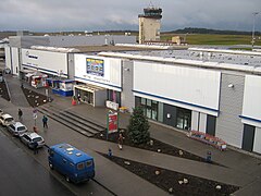
Hahn Airport, Terminal 1 (2007)


literature
- Caspar Scheuren : The Nahe valley: from the origin of the Nahe to its confluence with the Rhine; taken from nature . Verlag Kehr & Niessen, Coeln 1834, urn : nbn: de: 0128-1-4538 .
- Views from the Nahethal . Verlag Habicht, Bonn 1850, urn : nbn: de: 0128-1-2952 .
- Conrad Wiessner: Album des Nahethales . Verlag Voigtländer, Kreuznach 1862, urn : nbn: de: 0128-1-3411 .
- Francis Frith : The Nahethal . 1870, urn : nbn: de: 0128-1-3044 .
- Wilhelm Schneegans: Historical images and legends from the Nahethal . Verlag Schmithals, Kreuznach 1878, urn : nbn: de: 0128-1-9573 .
Web links
- Literature about the Nahe in the Saarland Bibliography
- Private website about the Nahe valley
- Aerial view of the Nahe estuary
- The Nahe, sometimes an irrepressible river (PDF, 934 KB)
Individual evidence
- ↑ a b c d Topographic map 1: 25,000.
- ↑ a b c GeoExplorer of the Rhineland-Palatinate Water Management Authority ( information )
- ↑ Grolsheim gauge value increased by the area runoff of approx. 5 l / (s * km²) in the remaining catchment area of 54 km².
- ↑ a b c Rhineland Water Management Administration ( memento of the original dated February 9, 2009 in the Internet Archive ) Info: The archive link was inserted automatically and has not yet been checked. Please check the original and archive link according to the instructions and then remove this notice.
- ↑ If on the map viewer Saarland studs Born called
- ^ Name at the Saarland map viewer