
Norheim
| coat of arms | Germany map | |
|---|---|---|

|
Coordinates: 49 ° 48 ' N , 7 ° 49' E |
|
| Basic data | ||
| State : | Rhineland-Palatinate | |
| County : | Bad Kreuznach | |
| Association municipality : | Rudesheim | |
| Height : | 119 m above sea level NHN | |
| Area : | 3.15 km 2 | |
| Residents: | 1541 (Dec. 31, 2019) | |
| Population density : | 489 inhabitants per km 2 | |
| Postal code : | 55585 | |
| Area code : | 0671 | |
| License plate : | KH | |
| Community key : | 07 1 33 071 | |
| LOCODE : | DE NRI | |
| Association administration address: | Nahestrasse 63 55593 Rüdesheim |
|
| Website : | ||
| Local Mayor : | Kai Michelmann | |
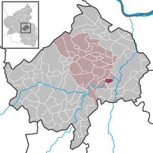
| Location of the local community Norheim in the Bad Kreuznach district | ||
  |
||

Norheim is a municipality in the Bad Kreuznach district in Rhineland-Palatinate . It belongs to the Verbandsgemeinde Rüdesheim .
Geographical location
Norheim is located in the Nahe valley near the Rheingrafenstein and the Rotenfels .
history
Norheim is the oldest documented wine village on the Nahe. It was sold to Lorsch Abbey in the “15th Year of King Pippin ”(766 or 767) called“ Narheim ”and“ in pago Nahgowe ”(Narheim im Nahegau) in the Lorsch Codex .
In 962 the property was exchanged from Lorsch to St. Maximin in Trier . In 1190 jurisdiction and property came to the lords of Bolanden from the empire as fief. From 1440 it came to the Sickinger on the Ebernburg for three centuries via the Rheingrafen and the Sponheimers . When the last representative died in 1768, the rule fell back to the Electoral Palatinate as an ownerless fief.
After the end of the Napoleonic wars and by the decisions of the Congress of Vienna (1815) Norheim was Prussian and 1816 the county Kreuznach in Koblenz assigned.
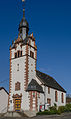
The Catholic parish church Raising the Cross at Norheim dates in parts (tower) from the first half of the 13th century. From 1363 it was incorporated into the St. Crucis Abbey (Heiligkreuzstift, also: Maria im Felde) in Mainz . After the Reformation up to 1698, the church was awarded the Evangelical Confession. It was given the current Gothic shape of the ship in 1864, and in 1911 the tower was raised by a slate sound chamber and given a pointed, eight-sided helmet . The tower stands in the east and used to form the choir . The entrance was also broken in 1911.
Norheim had three watermills . The oldest was the Witt'sche Mühle which was first mentioned in 1471. It was an old German gear mill with an undershot water wheel . There was cereal (1838-1852) also and according to Adam Karst oilseed ground. Since the mill was Bannmühle , the citizens of Norheim were only allowed to have their grain ground there. After the sale to Müller Krieger, the mill was shut down in 1833.
The second mill is the Steinsche Mühle (Krugermühle since 1910). It is 20 m below the Witt'schen Mühle and was built in 1722 as a property mill with the generous permission of Sickinger. Since the people of Norheim were banned from Witt'sche Mühle, the then owner Stein had to look for customers in Traisen and Hüffelsheim and buy grain at the Kreuznacher Kornmarkt and sell it there as flour. The Krugermühle was a grain mill with its own mill pond and an undershot picking wheel. This was in use until it was shut down in 1975. Since 1995 the system has been reactivated with a new wheel and generates electricity using an asynchronous generator . The expected annual output is 200,000 kWh.
The third mill is the willow mill at the eastern end of the village. It was built in 1726 by the miller Matthias Schmitt. It was a property mill in the Sickinger concession, where grain was ground. It was driven by an undershot water wheel. After the Witt'sche Bannmühle ceased operations at the beginning of the 19th century, the willow mill was the most important mill in Norheim. Their operation was stopped in 1950 after the death of the last miller, Hans Brosius.

- Population development
The development of the population of Norheim, the values from 1871 to 1987 are based on censuses:
|
|
politics
Municipal council
The local council in Norheim consists of 16 council members, who were elected in the local elections on May 26, 2019 in a personalized proportional representation, and the honorary local mayor as chairman.
The distribution of seats in the municipal council:
| choice | SPD | CDU | FDP | FL | total |
|---|---|---|---|---|---|
| 2019 | 4th | 3 | - | 9 | 16 seats |
| 2014 | 3 | - | - | 13 | 16 seats |
| 2009 | 5 | 9 | 2 | - | 16 seats |
| 2004 | 6th | 9 | 1 | - | 16 seats |
| 1999 | 8th | 7th | 1 | - | 16 seats |
- FL = “100% Norheim - Free list of the local community Norheim e. V. "
mayor
Kai Michelmann (FL “100 percent Norheim”) was sworn in as local mayor of Norheim on July 1, 2014. In the local elections on May 25, 2014, he was elected for the first time with a share of the vote of 75.2%. In the local election on May 26, 2019, he was confirmed in his office with a share of 71.44% of the votes.
Parish partnership
- A partnership has existed with Tannay in the Nièvre department in France since September 7, 1968.
Culture and sights
- Catholic Church Exaltation of the Cross in the center of Norheim
- former Catholic rectory; massive late baroque building from the 18th century
- Evangelical Church from 1901
See also: List of cultural monuments in Norheim
Norheim, Evangelical Church

Norheim, Catholic Church Exaltation of the Cross

Norheim, wayside cross from the 18th century.

Norheim, Catholic rectory from 1726


Economy and Infrastructure
traffic
The Norheim stop is on the Bingen – Saarbrücken railway line and is served by the RB 33 Mainz – Bad Kreuznach – Kirn – Idar-Oberstein line.
Personalities
- Kurt-Ulrich Mayer (* 1950), politician (CDU), professor and president of the Saxon State Agency for Private Broadcasting and New Media (SLM)
literature
- Gerd Spengel: Mills in the area of the Middle and Lower Nahe Volumes 1 and 2, local history series of the Bad Kreuznach district; 29.1 Verlag Gras & Jung. 1998.
- Walter Zimmermann: The art monuments of the Kreuznach district, Nachdr. D. Ed. Düsseldorf, Schwann, 1935 Pedagogical publisher Schwann-Bagel. 1985.
Web links
- Homepage of the local community Norheim
- Literature about Norheim in the Rhineland-Palatinate State Bibliography
Individual evidence
- ↑ a b State Statistical Office of Rhineland-Palatinate - population status 2019, districts, municipalities, association communities ( help on this ).
- ↑ Minst, Karl Josef [transl.]: Lorscher Codex (Volume 4), Certificate 2007, 766 or 767 - Reg. 241. In: Heidelberger historical stocks - digital. Heidelberg University Library, p. 16 , accessed on March 13, 2016 .
- ↑ The Mainz Heiligkreuz-Stift (in regionalgeschichte.net)
- ↑ Holy Cross - Maria in campis (in klosterlexikon-rlp.de)
- ↑ State Statistical Office Rhineland-Palatinate - regional data
- ^ The Regional Returning Officer Rhineland-Palatinate: Local council election 2019 Norheim. Retrieved June 8, 2020 .
- ^ The Regional Returning Officer for Rhineland-Palatinate: 2014 municipal council election, Norheim. Retrieved June 8, 2020 .
- ^ The Regional Returning Officer Rhineland-Palatinate: Local council election 2009 Norheim. Retrieved June 15, 2020 .
- ^ The Regional Returning Officer Rhineland-Palatinate: Local council election 2004 Norheim. Retrieved June 15, 2020 .
- ^ The Regional Returning Officer Rhineland-Palatinate: Local council election 2004 Norheim. see municipal council election 1999. Retrieved June 15, 2020 .
- ↑ 100% Norheim - Free list of the local community Norheim e. V. Accessed June 8, 2020 .
- ^ The Regional Returning Officer Rhineland-Palatinate: Municipal elections 2014. See Verbandsgemeinde Bad Münster am Stein-Ebernburg. Retrieved June 8, 2020 .
- ^ The Regional Returning Officer Rhineland-Palatinate: direct elections 2019. see Rüdesheim, Verbandsgemeinde, 17th line of results. Retrieved September 15, 2019 .

Abtweiler | Allenfeld | Altenbamberg | Eagle swings | Floodplains | Bad Kreuznach | Bad Sobernheim | Bärenbach | Bärweiler | Becherbach | Becherbach near Kirn | Biebelsheim | Bockenau | Boos | Braunweiler | Brauweiler | Breitenheim | Bretzenheim | Bruschied | Burgsponheim | Callbach | Dalberg | Daubach | Daxweiler | Desloch | Dörrebach | Dorsheim | Duchroth | Eckenroth | Feilbingert | Frei-Laubersheim | Fürfeld | Gebroth | Guldental | Gutenberg | Hackenheim | Hahnenbach | Hallgarten | Hargesheim | Heimweiler | Heinzenberg | Hennweiler | Hergenfeld | Hochstätten | Hochstetten-Dhaun | Horbach | Hüffelsheim | Hundsbach | Ippenschied | Jeckenbach | Kellenbach | Kirn | Cherry red | Königsau | Langenlonsheim | Langenthal | Laubenheim | Listener | Lettweiler | Limbach | Löllbach | Almond | Martinstein | Meckenbach | Meddersheim | Meisenheim | Merxheim | Monzingen | Münchwald | New Bamberg | Niederhausen | Norheim | Walnut | Oberhausen an der Nahe | Oberhausen near Kirn | Oberstreit | Odernheim am Glan | Otzweiler | Pfaffen-Schwabenheim | Pleitersheim | Raumbach | Rehbach | Rehborn | Reiffelbach | Roth | Roxheim | Rudesheim | Rümmelsheim | Saint Catherine | Schloßböckelheim | Schmittweiler | Schneppenbach | Schöneberg | Black earth | Schweinschied | Schweppenhausen | Seesbach | Seibersbach | Simmertal | Summer slump | Spa bridges | Spall | Sponheim | Staudernheim | Stromberg | Tiefenthal | Traisen | Volxheim | Waldböckelheim | Waldlaubersheim | Wallhausen | Warmsroth | Hamlet near Monzingen | Weinsheim | Weitersborn | Windesheim | Winterbach | Winterburg