
Frei-Laubersheim
| coat of arms | Germany map | |
|---|---|---|

|
Coordinates: 49 ° 48 ' N , 7 ° 54' E |
|
| Basic data | ||
| State : | Rhineland-Palatinate | |
| County : | Bad Kreuznach | |
| Association municipality : | Bad Kreuznach | |
| Height : | 180 m above sea level NHN | |
| Area : | 9.88 km 2 | |
| Residents: | 1044 (Dec. 31, 2019) | |
| Population density : | 106 inhabitants per km 2 | |
| Postal code : | 55546 | |
| Primaries : | 06703, 06709 | |
| License plate : | KH | |
| Community key : | 07 1 33 031 | |
| LOCODE : | DE FL9 | |
| Association administration address: | Rheingrafenstrasse 11 55543 Bad Kreuznach |
|
| Website : | ||
| Local Mayor : | Gustav Kühnle | |
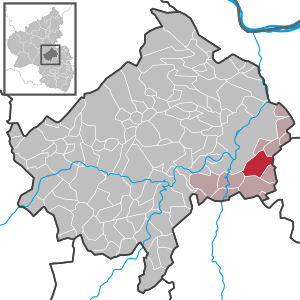
| Location of the local community Frei-Laubersheim in the Bad Kreuznach district | ||
  |
||


Frei-Laubersheim is a municipality in the Bad Kreuznach district in Rhineland-Palatinate . It belongs to the Bad Kreuznach community .
geography
The place is, like Fürfeld and Neu-Bamberg , in the Rheinhessische Schweiz . Frei-Laubersheim borders directly on the district town of Bad Kreuznach in the west .
Frei-Laubersheim also includes the residential spaces Am Bahnhof Laubersheim, Hof bei der Römerstraße, Johanneshof, Lindenhof and Rheingrafenhof.
history
The place was first mentioned in the year 767 as Liubherisheim in the Lorsch Codex . It was called Frei-Laubersheim or Kappes-Laubersheim to distinguish it from Waldlaubersheim bei Stromberg . The village was part of the Vorderen Grafschaft Sponheim early on . After the Counts of Sponheim died out, the territory was in divided ownership that changed several times. From 1707 Frei-Laubersheim belonged completely to the Electoral Palatinate due to a partition agreement . The place was assigned to the Oberamt Kreuznach .
After the Left Bank of the Rhine was taken by French revolutionary troops (1794), the region belonged from 1798 to 1814 to the Donnersberg department , which was newly established under French administration , Frei-Laubersheim was assigned to the canton of Wöllstein , and the village became the capital of a Mairie in 1800 , which also included Volxheim belonged.
Due to the agreements made at the Congress of Vienna , the region later known as Rheinhessen and thus Frei-Laubersheim became part of the Grand Duchy of Hesse in 1816 .
- Population development
The development of the population of Frei-Laubersheim, the values from 1871 to 1987 are based on censuses:
|
|
politics
Municipal council
The municipal council in Frei-Laubersheim consists of 16 council members, who were elected in the local elections on May 26, 2019 in a personalized proportional representation, and the honorary local mayor as chairman.
The distribution of seats in the municipal council:
| choice | SPD | CDU | WGR | BL | total |
|---|---|---|---|---|---|
| 2019 | 3 | 3 | 3 | 7th | 16 seats |
| 2014 | 3 | 5 | 2 | 6th | 16 seats |
| 2009 | 3 | 4th | 2 | 7th | 16 seats |
| 2004 | 3 | 5 | 2 | 6th | 16 seats |
- BL = Bürgerliste Frei-Laubersheim e. V.
mayor
The local mayor is Gustav Kühnle (list of citizens). In the local elections on May 26, 2019, he was elected with a share of the vote of 66.40% and is the successor to Heinz Bergmann (CDU), who was no longer running.
coat of arms
|
|
Blazon : “Lowered silver tip curved in front, inside a blue Franconian clasp brooch , split; front in blue and gold geschacht , back in black and a red reinforced and red crowned golden lion. " |
| Justification for the coat of arms: Blue and gold were the colors of the Counts of Sponheim . The lion refers to the belonging to the Electoral Palatinate . The blue clasp brooch is from a Franconian grave find. It is a historical reference to the early settlement of the area around Frei-Laubersheim by the Franks. |
Culture and sights
Buildings
- Catholic parish church of St. Mauritius, built from 1792 to 1796
- Free-standing defense tower, 13th century
- Former Catholic rectory from 1720
- Chaplain building
Regular events
- Frei-Laubersheimer Kerwe, every year on the third weekend in September
- Frei-Laubersheimer open studios, every year on the third weekend in September
Economy and Infrastructure
Viticulture
Frei-Laubersheim belongs to the " Bingen wine-growing area " in the Rheinhessen growing area . There are 20 wine-growing businesses in the village, and the area under vines is 121 hectares . About 77 percent of the wine grown are white grape varieties (as of 2007). In 1979 there were still 48 farms active, the vineyard area at that time was 116 hectares.
traffic
- The federal highway 420 runs through the village . In the northeast is the federal highway 61 .
- The train station in Frei-Laubersheim was on the Sprendlingen – Fürfeld railway line opened in 1898 . It was shut down in 1960. Trains from the Alsenz Valley Railway and the Nahe Valley Railway stop in nearby Bad Kreuznach .
Personalities
- Alfred Blaufuß (1912–1995), botanist, nature conservationist, headmaster, Order of Merit of the State of Rhineland-Palatinate 1982
- Bernd Rusinski (* 1956), pop singer
- Siegfried Kärcher (* 1974), visual artist, musician, Moldau scholarship holder of the state of Hesse 2009, scholarship holder of the state of Rhineland-Palatinate Künstlerhaus Schloss Balmoral 2020
Web links
- History of Frei-Laubersheim on regionalgeschichte.net
- Literature about Frei-Laubersheim in the Rhineland-Palatinate state bibliography
Individual evidence
- ↑ State Statistical Office of Rhineland-Palatinate - population status 2019, districts, communities, association communities ( help on this ).
- ↑ State Statistical Office Rhineland-Palatinate (ed.): Official directory of the municipalities and parts of the municipality. Status: January 2019 [ Version 2020 is available. ] . S. 21 (PDF; 3 MB).
- ↑ a b State Statistical Office Rhineland-Palatinate: Regional data.
- ^ The Regional Returning Officer Rhineland-Palatinate: Local elections 2019, city and municipal council elections
- ^ The Regional Returning Officer RLP: direct elections 2019. see Bad Kreuznach, Verbandsgemeinde, fourth line of results. Retrieved September 13, 2019 .

Abtweiler | Allenfeld | Altenbamberg | Eagle swings | Floodplains | Bad Kreuznach | Bad Sobernheim | Bärenbach | Bärweiler | Becherbach | Becherbach near Kirn | Biebelsheim | Bockenau | Boos | Braunweiler | Brauweiler | Breitenheim | Bretzenheim | Bruschied | Burgsponheim | Callbach | Dalberg | Daubach | Daxweiler | Desloch | Dörrebach | Dorsheim | Duchroth | Eckenroth | Feilbingert | Frei-Laubersheim | Fürfeld | Gebroth | Guldental | Gutenberg | Hackenheim | Hahnenbach | Hallgarten | Hargesheim | Heimweiler | Heinzenberg | Hennweiler | Hergenfeld | Hochstätten | Hochstetten-Dhaun | Horbach | Hüffelsheim | Hundsbach | Ippenschied | Jeckenbach | Kellenbach | Kirn | Cherry red | Königsau | Langenlonsheim | Langenthal | Laubenheim | Listener | Lettweiler | Limbach | Löllbach | Almond | Martinstein | Meckenbach | Meddersheim | Meisenheim | Merxheim | Monzingen | Münchwald | New Bamberg | Niederhausen | Norheim | Walnut | Oberhausen an der Nahe | Oberhausen near Kirn | Oberstreit | Odernheim am Glan | Otzweiler | Pfaffen-Schwabenheim | Pleitersheim | Raumbach | Rehbach | Rehborn | Reiffelbach | Roth | Roxheim | Rudesheim | Rümmelsheim | Saint Catherine | Schloßböckelheim | Schmittweiler | Schneppenbach | Schöneberg | Black earth | Schweinschied | Schweppenhausen | Seesbach | Seibersbach | Simmertal | Summer slump | Spa bridges | Spall | Sponheim | Staudernheim | Stromberg | Tiefenthal | Traisen | Volxheim | Waldböckelheim | Waldlaubersheim | Wallhausen | Warmsroth | Hamlet near Monzingen | Weinsheim | Weitersborn | Windesheim | Winterbach | Winterburg