
Auen (Hunsrück)
| coat of arms | Germany map | |
|---|---|---|

|
Coordinates: 49 ° 50 ' N , 7 ° 36' E |
|
| Basic data | ||
| State : | Rhineland-Palatinate | |
| County : | Bad Kreuznach | |
| Association municipality : | Nahe-Glan | |
| Height : | 235 m above sea level NHN | |
| Area : | 2.71 km 2 | |
| Residents: | 184 (Dec. 31, 2019) | |
| Population density : | 68 inhabitants per km 2 | |
| Postal code : | 55569 | |
| Area code : | 06754 | |
| License plate : | KH | |
| Community key : | 07 1 33 005 | |
| Association administration address: | Marktplatz 11 55566 Bad Sobernheim |
|
| Website : | ||
| Local Mayor : | Torsten Baus | |
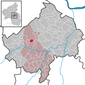
| Location of the local community Auen in the Bad Kreuznach district | ||
  |
||


Auen is a municipality in the Bad Kreuznach district in Rhineland-Palatinate . It belongs to the community of Nahe-Glan . Auen is a state-approved resort .
geography
Auen lies in the southern Hunsrück between the mountain ranges of the Soonwald and the Nahe river . Langenthal is to the west and Daubach to the east .
The Gosenhof residential area also belongs to the meadows .
population
- Statistics on population development
The development of the population of floodplains, the values from 1871 to 1987 are based on censuses:
|
|
politics
Municipal council
The municipal council in Auen consists of six council members, who were elected by a majority vote in the local elections on May 26, 2019 , and the honorary local mayor as chairman.
mayor
Local mayor is Torsten Baus. In the municipal election on May 26, 2019, he prevailed against the previous incumbent Andreas Seidenzahl with a share of 64.80% of the vote.
coat of arms
|
|
Blazon : “Shield divided by a silver sloping bar, which is covered with a black A. Above blue-gold chess, below in blue a golden curve. " |
| Justification for the coat of arms: The sloping bar with the letter “A” for floodplains goes back to a court seal from 1731. The abbot refers to Archbishop Bardo of Mainz , who listed floodplains among other localities in a deed of donation in 1044. The checkerboard pattern is reminiscent of the county of Sponheim , which Auen belonged to until the end of the 18th century. |
Buildings
- 1,000-year-old Willigis Chapel with grave of Friedrich Wilhelm Utsch ( The Hunter from Electoral Palatinate )
- Evangelical Church Lapis Primarius - front window from Röhrig / Bensberg
Economy and Infrastructure
The federal highway 41 runs in the south . In Monzingen there is a train station on the Bingen – Saarbrücken line .
Web links
- Website of the local community Auen
- Local community Auen on the website of the Bad Sobernheim community community
- Literature on floodplains in the Rhineland-Palatinate state bibliography
Individual evidence
- ↑ State Statistical Office of Rhineland-Palatinate - population status 2019, districts, communities, association communities ( help on this ).
- ↑ a b State Statistical Office Rhineland-Palatinate - regional data
- ↑ State Statistical Office Rhineland-Palatinate (ed.): Official directory of the municipalities and parts of the municipality. Status: January 2018 [ Version 2020 is available. ] . S. 17 (PDF; 2.2 MB).
- ↑ The Regional Returning Officer RLP: Municipal Council Election 2019 Auen. Retrieved September 20, 2019 .
- ↑ The regional returning officer RLP: direct elections 2019. see Bad Sobernheim, Verbandsgemeinde, first line of results. Retrieved September 20, 2019 .

Abtweiler | Allenfeld | Altenbamberg | Eagle swings | Floodplains | Bad Kreuznach | Bad Sobernheim | Bärenbach | Bärweiler | Becherbach | Becherbach near Kirn | Biebelsheim | Bockenau | Boos | Braunweiler | Brauweiler | Breitenheim | Bretzenheim | Bruschied | Burgsponheim | Callbach | Dalberg | Daubach | Daxweiler | Desloch | Dörrebach | Dorsheim | Duchroth | Eckenroth | Feilbingert | Frei-Laubersheim | Fürfeld | Gebroth | Guldental | Gutenberg | Hackenheim | Hahnenbach | Hallgarten | Hargesheim | Heimweiler | Heinzenberg | Hennweiler | Hergenfeld | Hochstätten | Hochstetten-Dhaun | Horbach | Hüffelsheim | Hundsbach | Ippenschied | Jeckenbach | Kellenbach | Kirn | Cherry red | Königsau | Langenlonsheim | Langenthal | Laubenheim | Listener | Lettweiler | Limbach | Löllbach | Almond | Martinstein | Meckenbach | Meddersheim | Meisenheim | Merxheim | Monzingen | Münchwald | New Bamberg | Niederhausen | Norheim | Walnut | Oberhausen an der Nahe | Oberhausen near Kirn | Oberstreit | Odernheim am Glan | Otzweiler | Pfaffen-Schwabenheim | Pleitersheim | Raumbach | Rehbach | Rehborn | Reiffelbach | Roth | Roxheim | Rudesheim | Rümmelsheim | Saint Catherine | Schloßböckelheim | Schmittweiler | Schneppenbach | Schöneberg | Black earth | Schweinschied | Schweppenhausen | Seesbach | Seibersbach | Simmertal | Summer slump | Spa bridges | Spall | Sponheim | Staudernheim | Stromberg | Tiefenthal | Traisen | Volxheim | Waldböckelheim | Waldlaubersheim | Wallhausen | Warmsroth | Hamlet near Monzingen | Weinsheim | Weitersborn | Windesheim | Winterbach | Winterburg