
Otzweiler
| coat of arms | Germany map | |
|---|---|---|

|
Coordinates: 49 ° 43 ' N , 7 ° 31' E |
|
| Basic data | ||
| State : | Rhineland-Palatinate | |
| County : | Bad Kreuznach | |
| Association municipality : | Kirner Land | |
| Height : | 300 m above sea level NHN | |
| Area : | 3.11 km 2 | |
| Residents: | 191 (Dec. 31, 2019) | |
| Population density : | 61 inhabitants per km 2 | |
| Postal code : | 55606 | |
| Area code : | 06757 | |
| License plate : | KH | |
| Community key : | 07 1 33 077 | |
| Association administration address: | Bahnhofstrasse 31 55606 Kirn |
|
| Website : | ||
| Mayoress : | Natalie Kleyer | |
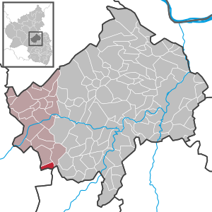
| Location of the local community Otzweiler in the Bad Kreuznach district | ||
  |
||

Otzweiler is a municipality in the Bad Kreuznach district in Rhineland-Palatinate . It belongs to the Kirner Land association.
geography
Otzweiler is located on the Großbach in the North Palatinate Bergland . In the north is Becherbach bei Kirn , in the east Hundsbach , in the south Sien and in the west is Oberreidenbach .
history
Little is known about Otzweiler from the early and high Middle Ages. In the 14th century Otzweiler belonged to the rule of the wild counts on the Kyrburg . In 1375, the wild counts Otto and Friedrich von Kyrburg shared goods and rights that they owned in the "Amt Otzweiler" (including Hundsbach , Schweinschied , Löllbach ) among themselves.
Fabricius suspects that the place arose from a wildgrave court of the Becherbach court and originally belonged to the high court on the heath. Otzweiler, which only consisted of this farm and two mills, has developed into a larger settlement in later times. At the beginning of the 16th century, the place belonged to the Schultheisserei Sien within the Wildgrave's office of Kyrburg . As Sponheim subjects also lived in Otzweiler, the Counts of Sponheim or their legal successors, the Margrave of Baden , as the owner of the Naumburg office (seat of Naumburg Castle near Bärenbach ) , also claimed territorial sovereignty over the place. The resulting legal disputes between the Salm-Kyrburg office and the Naumburg office in Baden were settled in 1757 to the effect that the property and residents of Otzweiler should remain under the joint administration of the two offices.
The local residents were only subjected to a uniform administration when the French assigned the site to the newly created Mairie Schmidthachenbach in the canton of Grumbach in 1798 in the Saar department .
After the end of French rule in 1814 and a brief membership in Prussia, Otzweiler was able to join the Becherbach high school in 1816 in the Hesse-Homburg Oberamt Meisenheim .
After the Becherbach office was dissolved (1940), Otzweiler came to the Kirn-Land office .
In 1864 71 families lived in 57 houses in Otzweiler. The majority of the community, which had more than 300 inhabitants, was Protestant. Today the place still has about 210 inhabitants.
On January 11, 1800, Schinderhannes committed a robbery in Otzweiler and then fled to the right bank of the Rhine.
- Population development
The development of the population of Otzweiler, the values from 1871 to 1987 are based on censuses:
|
|
politics
Municipal council
The council in Otzweiler consists of six council members, who in the local elections on May 26, 2019 in a majority vote were elected, and the volunteer local mayor as chairman.
mayor
Natalie Kleyer is the local mayor. No candidate ran in the local elections on May 26, 2019, so their election was made by the local council on June 26, 2019. She is the successor to Frank Müller, who was no longer running.
coat of arms
|
|
Blazon : "A red millstone topped with a golden mill iron over a blue-gold shield base in silver." |
|
Reasons for the coat of arms: The field is a reference to the former affiliation to the Vordere Grafschaft Sponheim . Mühlstein und Mühleisen reminds of the origin of the village of Otzweiler. According to Pastor Lentze in his book “Amt Naumburg und Pfarrei Becherbach”, (p. 31), Otzweiler was only a farm with two mills in 1599 - before old it was only one mill.
On February 3, 1966, the municipal council commissioned the graphic designer Brust, Kirnsulzbach, to develop a design for a municipal coat of arms. At its meeting on June 8, 1966, the Council approved the draft presented. After approval by the State Archives, the Ministry of the Interior in Mainz granted permission on July 4, 1966 to use one's own coat of arms. |
Economy and Infrastructure
Federal highway 270 runs to the south . In Kirn there is a train station on the Bingen – Saarbrücken line .
See also
Web links
- Ortgemeinde Otzweiler on the website of the Verbandsgemeinde Kirn-Land
- Literature about Otzweiler in the Rhineland-Palatinate State Bibliography
Individual evidence
- ↑ a b State Statistical Office of Rhineland-Palatinate - population status 2019, districts, municipalities, association communities ( help on this ).
- ↑ a b Statistical Maps, Verbandsgemeinde Kirn-Land, 2009
- ↑ State Statistical Office Rhineland-Palatinate - regional data
- ^ The regional returning officer RLP: Local council election 2019 Otzweiler. Retrieved September 23, 2019 .
- ↑ The regional returning officer RLP: direct elections 2019. see Kirn-Land, Verbandsgemeinde, 15th line of results. Retrieved September 23, 2019 .
- ↑ Information sheet Kirn-Land for the area of the Verbandsgemeinde: Minutes of the meeting of the Otzweiler local council on June 26th, 2019. Edition 28/2019, Official notices and notices from the local congregations. Retrieved September 23, 2019 .

Abtweiler | Allenfeld | Altenbamberg | Eagle swings | Floodplains | Bad Kreuznach | Bad Sobernheim | Bärenbach | Bärweiler | Becherbach | Becherbach near Kirn | Biebelsheim | Bockenau | Boos | Braunweiler | Brauweiler | Breitenheim | Bretzenheim | Bruschied | Burgsponheim | Callbach | Dalberg | Daubach | Daxweiler | Desloch | Dörrebach | Dorsheim | Duchroth | Eckenroth | Feilbingert | Frei-Laubersheim | Fürfeld | Gebroth | Guldental | Gutenberg | Hackenheim | Hahnenbach | Hallgarten | Hargesheim | Heimweiler | Heinzenberg | Hennweiler | Hergenfeld | Hochstätten | Hochstetten-Dhaun | Horbach | Hüffelsheim | Hundsbach | Ippenschied | Jeckenbach | Kellenbach | Kirn | Cherry red | Königsau | Langenlonsheim | Langenthal | Laubenheim | Listener | Lettweiler | Limbach | Löllbach | Almond | Martinstein | Meckenbach | Meddersheim | Meisenheim | Merxheim | Monzingen | Münchwald | New Bamberg | Niederhausen | Norheim | Walnut | Oberhausen an der Nahe | Oberhausen near Kirn | Oberstreit | Odernheim am Glan | Otzweiler | Pfaffen-Schwabenheim | Pleitersheim | Raumbach | Rehbach | Rehborn | Reiffelbach | Roth | Roxheim | Rudesheim | Rümmelsheim | Saint Catherine | Schloßböckelheim | Schmittweiler | Schneppenbach | Schöneberg | Black earth | Schweinschied | Schweppenhausen | Seesbach | Seibersbach | Simmertal | Summer slump | Spa bridges | Spall | Sponheim | Staudernheim | Stromberg | Tiefenthal | Traisen | Volxheim | Waldböckelheim | Waldlaubersheim | Wallhausen | Warmsroth | Hamlet near Monzingen | Weinsheim | Weitersborn | Windesheim | Winterbach | Winterburg