
Argwang
| coat of arms | Germany map | |
|---|---|---|

|
Coordinates: 49 ° 53 ' N , 7 ° 42' E |
|
| Basic data | ||
| State : | Rhineland-Palatinate | |
| County : | Bad Kreuznach | |
| Association municipality : | Rudesheim | |
| Height : | 295 m above sea level NHN | |
| Area : | 4.25 km 2 | |
| Residents: | 331 (Dec. 31, 2019) | |
| Population density : | 78 inhabitants per km 2 | |
| Postal code : | 55595 | |
| Area code : | 06706 | |
| License plate : | KH | |
| Community key : | 07 1 33 004 | |
| LOCODE : | DE 5AU | |
| Association administration address: | Nahestrasse 63 55593 Rüdesheim |
|
| Website : | ||
| Mayoress : | Petra Ender | |
| Location of the local community Argenschwang in the Bad Kreuznach district | ||
  |
||

Argenschwang is a municipality in the Bad Kreuznach district in Rhineland-Palatinate . It belongs to the Verbandsgemeinde Rüdesheim .
geography
Argenschwang is located in the southern Hunsrück , between the Soonwald and the Gauchswald , on the 361 meter high Geisberg.
The Webersmühle and Wiesenhof residential areas also belong to Argenschwang .
history
The place was first mentioned in 1127 as Hausen . This place name was in use until the 16th century.
- Population development
The development of the population of Argenschwang, the values from 1871 to 1987 are based on censuses:
|
|
politics
Municipal council
The council in Argenschwang consists of eight council members, who in the local elections on May 26, 2019 in a majority vote were elected, and the volunteer local mayor as chairman.
mayor
Local mayor is Petra Ender. In the local elections on May 26, 2019, she was elected with 79.36% of the vote and is the successor to Bernd Metzler, who did not run again after 20 years in office.
Culture and sights
The castle Argenschwang was in the 12th century by the Counts of Sponheim built.
See also: List of cultural monuments in Argenschwang
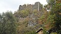
Rosenburg castle ruins

Rosenburg castle ruins; Former gatehouse

Former synagogue (17th and 18th centuries)

Argenschwang Church, Argenschwang Castle in the background


literature
- Literature about Argenschwang in the Rhineland-Palatinate State Bibliography
Web links
- Argenschwang parish
- Literature about Argenschwang in the Rhineland-Palatinate State Bibliography
Individual evidence
- ↑ a b State Statistical Office of Rhineland-Palatinate - population status 2019, districts, municipalities, association communities ( help on this ).
- ↑ State Statistical Office Rhineland-Palatinate (ed.): Official directory of the municipalities and parts of the municipality. Status: January 2018 [ Version 2020 is available. ] . S. 16 (PDF; 2.2 MB).
- ↑ State Statistical Office Rhineland-Palatinate - regional data
- ^ The Regional Returning Officer RLP: City Council Election 2019 Argenschwang. Retrieved September 16, 2019 .
- ^ The regional returning officer RLP: direct elections 2019. see Rüdesheim, Verbandsgemeinde, second line of results. Retrieved September 16, 2019 .

Abtweiler | Allenfeld | Altenbamberg | Eagle swings | Floodplains | Bad Kreuznach | Bad Sobernheim | Bärenbach | Bärweiler | Becherbach | Becherbach near Kirn | Biebelsheim | Bockenau | Boos | Braunweiler | Brauweiler | Breitenheim | Bretzenheim | Bruschied | Burgsponheim | Callbach | Dalberg | Daubach | Daxweiler | Desloch | Dörrebach | Dorsheim | Duchroth | Eckenroth | Feilbingert | Frei-Laubersheim | Fürfeld | Gebroth | Guldental | Gutenberg | Hackenheim | Hahnenbach | Hallgarten | Hargesheim | Heimweiler | Heinzenberg | Hennweiler | Hergenfeld | Hochstätten | Hochstetten-Dhaun | Horbach | Hüffelsheim | Hundsbach | Ippenschied | Jeckenbach | Kellenbach | Kirn | Cherry red | Königsau | Langenlonsheim | Langenthal | Laubenheim | Listener | Lettweiler | Limbach | Löllbach | Almond | Martinstein | Meckenbach | Meddersheim | Meisenheim | Merxheim | Monzingen | Münchwald | New Bamberg | Niederhausen | Norheim | Walnut | Oberhausen an der Nahe | Oberhausen near Kirn | Oberstreit | Odernheim am Glan | Otzweiler | Pfaffen-Schwabenheim | Pleitersheim | Raumbach | Rehbach | Rehborn | Reiffelbach | Roth | Roxheim | Rudesheim | Rümmelsheim | Saint Catherine | Schloßböckelheim | Schmittweiler | Schneppenbach | Schöneberg | Black earth | Schweinschied | Schweppenhausen | Seesbach | Seibersbach | Simmertal | Summer slump | Spa bridges | Spall | Sponheim | Staudernheim | Stromberg | Tiefenthal | Traisen | Volxheim | Waldböckelheim | Waldlaubersheim | Wallhausen | Warmsroth | Hamlet near Monzingen | Weinsheim | Weitersborn | Windesheim | Winterbach | Winterburg