Martinstein
| coat of arms | Germany map | |
|---|---|---|

|
Coordinates: 49 ° 48 ' N , 7 ° 32' E |
|
| Basic data | ||
| State : | Rhineland-Palatinate | |
| County : | Bad Kreuznach | |
| Association municipality : | Nahe-Glan | |
| Height : | 190 m above sea level NHN | |
| Area : | 0.39 km 2 | |
| Residents: | 271 (Dec. 31, 2019) | |
| Population density : | 695 inhabitants per km 2 | |
| Postal code : | 55627 | |
| Area code : | 06754 | |
| License plate : | KH | |
| Community key : | 07 1 33 062 | |
| Association administration address: | Marktplatz 11 55566 Bad Sobernheim |
|
| Website : | ||
| Local Mayor : | Paul-Walter Bock | |
| Location of the local community Martinstein in the Bad Kreuznach district | ||
Martinstein is a municipality in the Bad Kreuznach district in Rhineland-Palatinate . It belongs to the community of Nahe-Glan . With 39 hectares, Martinstein is the smallest municipality in Germany .
geography
Martinstein is located directly on the left bank of the Nahe . The Hunsrück rises to the north and the North Palatinate Mountains to the south . In the west there are Simmertal and Hochstetten-Dhaun , in the east hamlets near Monzingen and Merxheim .
history
The place was created in the High Middle Ages at a crossing of the Nahe on the district of Simmern under Dhaun . In 1340 the Archbishop of Mainz built a castle over the town during the "Dhauner Feud" against the Wildgrave on Dhaun , two years later the town received city rights . In 1518 Martinstein received its own small district . In the 18th century the place came into the possession of the margraviate of Baden and was subordinated to the office of Naumburg . From 1798 to 1814 Martinstein was assigned to the French canton of Sobernheim in the Donnersberg department. Due to the agreements made at the Congress of Vienna , the region and with it Martinstein came to the Kingdom of Prussia in 1815 . The community was from the mayor Monzingen in county Kreuznach in Koblenz managed.
In 1966, the boundary was changed so that the parts of the village, which until then lay on areas of Simmern under Dhaun, Weiler near Monzingen and Merxheim, came to Martinstein.
- Population development
The development of the population of Martinstein, the values from 1871 to 1987 are based on censuses:
|
|
politics
Municipal council
The municipal council in Martinstein consists of six council members, who were elected in the local elections on May 26, 2019 in a majority vote, and the honorary local mayor as chairman. Until 2014, the council had eight councilors.
coat of arms
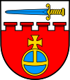
| Blazon : "From a silver shield head, inside a blue sword, divided by a pinnacle cut with four battlements, below in red a blue orb , gold edged with a golden paw cross." | |
| Justification for the coat of arms: The sword is the attribute of St. Martin , the patron and namesake of the place. The Reichsapfel stands for the former imperial knighthood status. The battlements symbolize the castle, the number four stands for the place previously divided into four districts. |
Economy and Infrastructure
The federal road 41 leads directly through the village. Martinstein has a stop (a former train station) on the Nahe Valley Railway Bingen - Saarbrücken .
Martinstein has a restaurant, an ice cream parlor, two bakeries and a household goods store.
See also
Web links
- Local community Martinstein on the website of the Bad Sobernheim community community
- Literature about Martinstein in the Rhineland-Palatinate state bibliography
literature
- Konrad Schneider: An attempt at a history of the Veste Martinstein and its owners . In: Wetzlar'sche contributions for history and legal antiquities 2 (1845), pp. 27–52 ( Google Books )
- Friedrich Toepfer: Side dishes. VII. Martinstein . In: ders. (Ed.): Document book for the history of the royal and baronial house of the Voegte von Hunolstein , Vol. II. Jacob Zeiser, Nuremberg 1867, pp. 460–464 ( Google Books )
Individual evidence
- ↑ a b State Statistical Office of Rhineland-Palatinate - population status 2019, districts, municipalities, association communities ( help on this ).
- ↑ a b State Statistical Office Rhineland-Palatinate - regional data
- ↑ Hauptstraße in Martinstein from the SWR Landesschau Rheinland-Pfalz accessed on June 16, 2014.
- ^ The Regional Returning Officer RLP: City Council Election 2019 Martinstein. Retrieved September 20, 2019 .


