
New Bamberg
| coat of arms | Germany map | |
|---|---|---|

|
Coordinates: 49 ° 48 ' N , 7 ° 55' E |
|
| Basic data | ||
| State : | Rhineland-Palatinate | |
| County : | Bad Kreuznach | |
| Association municipality : | Bad Kreuznach | |
| Height : | 160 m above sea level NHN | |
| Area : | 4.56 km 2 | |
| Residents: | 951 (Dec. 31, 2019) | |
| Population density : | 209 inhabitants per km 2 | |
| Postal code : | 55546 | |
| Area code : | 06703 | |
| License plate : | KH | |
| Community key : | 07 1 33 069 | |
| Association administration address: | Rheingrafenstrasse 11 55543 Bad Kreuznach |
|
| Website : | ||
| Local Mayor : | Markus Müller (Free Voters) | |
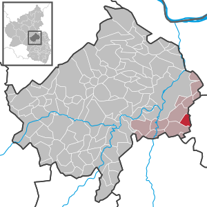
| Location of the local community Neu-Bamberg in the Bad Kreuznach district | ||
  |
||


Neu-Bamberg is a municipality in the Bad Kreuznach district in Rhineland-Palatinate . It belongs to the Bad Kreuznach community .
geography
The wine village is in the Rheinhessen Switzerland . Neu-Bamberg also includes the residential areas An der Weidenmühle, Waltershecke and Weidenmühle.
history
In the Middle Ages the place and its castle was called Neu-Baumburg, in contrast to the one hour's walk away Baumburg an der Alsenz , which was also built by the Raugrafen in the 12th century, then renamed Alt Baumburg ( Altenbaumburg ) and the village to distinguish it Altenbamberg has given its name. Until the end of the 18th century, Neubamberg belonged to Kurmainz .
During the so-called French period , the place was assigned to the canton of Wöllstein in the Donnersberg department. Due to the agreements reached at the Congress of Vienna in 1815 and a state treaty concluded in 1816 between Hesse , Austria and Prussia , the region and with it the municipality of “Neubamberg” came to the Grand Duchy of Hesse and was assigned to the province of Rheinhessen by this . After the dissolution of the Rhine-Hessian cantons, the place came to the newly established Bingen district in 1835 and to the Alzey district in 1852 . According to the writing practice in the Grand Duchy of Hesse , the place is now spelled with a hyphen.
Neu-Bamberg was on the Sprendlingen – Fürfeld railway line opened in 1898 . It was shut down in 1960.
- Population development
The development of the population of Neu-Bamberg, the values from 1871 to 1987 are based on censuses:
|
|
politics
Municipal council
The municipal council in Neu-Bamberg consists of twelve council members, who were elected in a personalized proportional representation in the local elections on May 26, 2019 , and the honorary local mayor as chairman.
The distribution of seats in the municipal council:
| choice | SPD | CDU | FWG | total |
|---|---|---|---|---|
| 2019 | 4th | 2 | 6th | 12 seats |
| 2014 | 5 | 3 | 4th | 12 seats |
| 2009 | 5 | 3 | 4th | 12 seats |
| 2004 | 6th | 3 | 3 | 12 seats |
- FWG = Free Community of Voters Neu-Bamberg
mayor
The local mayor is Markus Müller (Free Voters). In the local elections on May 26, 2019, he was elected with a share of 54.17% of the vote and is the successor to Marc Ullrich, who was no longer running.
coat of arms
|
|
Blazon : "In silver on a green three-mountain, a green leafy oak tree." |
| Justification of the coat of arms: It goes back to a court seal from 1584 and symbolizes the place name. |
Economy and Infrastructure
Viticulture
Neu-Bamberg belongs to the "Bingen wine-growing area" in the Rheinhessen growing region . Eight wine-growing businesses are active in the village, and the area under vines is 58 hectares . About 76% of the cultivated wine are white wine grape varieties (as of 2007). In 1979, 18 businesses were still active, the vineyard area at that time was 54 hectares.
traffic
The place is passed by the federal highway 420 , which serves as a feeder to the federal highway 61 .
Public facilities
- kindergarten
Born in Neu-Bamberg
- Hubert Luttenberger (* 1926), motorcycle racer
literature
- Alexander Thon, Martin Wenz: Neuenbaumburg . In: Jürgen Keddigkeit, Alexander Thon u. a. (Ed.): Palatinate Castle Lexicon (= contributions to Palatinate history . Volume 12 ). tape 3 . Kaiserslautern 2005, p. 706-717 .
See also
Web links
- Internet presence of the local community Neu-Bamberg
- Private page about the local community Neu-Bamberg
- History of Neu-Bamberg on regionalgeschichte.net
- Literature about Neu-Bamberg in the Rhineland-Palatinate state bibliography
Individual evidence
- ↑ State Statistical Office of Rhineland-Palatinate - population status 2019, districts, communities, association communities ( help on this ).
- ↑ State Statistical Office Rhineland-Palatinate (ed.): Official directory of the municipalities and parts of the municipality. Status: January 2018 [ Version 2020 is available. ] . S. 14 (PDF; 2.2 MB).
- ↑ a b State Statistical Office Rhineland-Palatinate - regional data
- ^ The Regional Returning Officer RLP: City Council Election 2019 Neu-Bamberg. Retrieved September 13, 2019 .
- ^ The Regional Returning Officer Rhineland-Palatinate: Municipal elections 2014, city and municipal council elections
- ^ The regional returning officer RLP: direct elections 2019. see Bad Kreuznach, Verbandsgemeinde, ninth line of results. Retrieved September 13, 2019 .

Abtweiler | Allenfeld | Altenbamberg | Eagle swings | Floodplains | Bad Kreuznach | Bad Sobernheim | Bärenbach | Bärweiler | Becherbach | Becherbach near Kirn | Biebelsheim | Bockenau | Boos | Braunweiler | Brauweiler | Breitenheim | Bretzenheim | Bruschied | Burgsponheim | Callbach | Dalberg | Daubach | Daxweiler | Desloch | Dörrebach | Dorsheim | Duchroth | Eckenroth | Feilbingert | Frei-Laubersheim | Fürfeld | Gebroth | Guldental | Gutenberg | Hackenheim | Hahnenbach | Hallgarten | Hargesheim | Heimweiler | Heinzenberg | Hennweiler | Hergenfeld | Hochstätten | Hochstetten-Dhaun | Horbach | Hüffelsheim | Hundsbach | Ippenschied | Jeckenbach | Kellenbach | Kirn | Cherry red | Königsau | Langenlonsheim | Langenthal | Laubenheim | Listener | Lettweiler | Limbach | Löllbach | Almond | Martinstein | Meckenbach | Meddersheim | Meisenheim | Merxheim | Monzingen | Münchwald | New Bamberg | Niederhausen | Norheim | Walnut | Oberhausen an der Nahe | Oberhausen near Kirn | Oberstreit | Odernheim am Glan | Otzweiler | Pfaffen-Schwabenheim | Pleitersheim | Raumbach | Rehbach | Rehborn | Reiffelbach | Roth | Roxheim | Rudesheim | Rümmelsheim | Saint Catherine | Schloßböckelheim | Schmittweiler | Schneppenbach | Schöneberg | Black earth | Schweinschied | Schweppenhausen | Seesbach | Seibersbach | Simmertal | Summer slump | Spa bridges | Spall | Sponheim | Staudernheim | Stromberg | Tiefenthal | Traisen | Volxheim | Waldböckelheim | Waldlaubersheim | Wallhausen | Warmsroth | Hamlet near Monzingen | Weinsheim | Weitersborn | Windesheim | Winterbach | Winterburg