
Alsenz (near)
| Alsenz | ||
 River course |
||
| Data | ||
| Water code | EN : 2548 | |
| location |
Palatinate Forest
|
|
| River system | Rhine | |
| Drain over | Nahe → Rhine → North Sea | |
| source | from Alsenborn 49 ° 29 ′ 28 ″ N , 7 ° 55 ′ 25 ″ E |
|
| Source height | approx. 292 m above sea level NHN | |
| muzzle | at Ebernburg from the right to the Nahe coordinates: 49 ° 48 '27 " N , 7 ° 50' 34" E 49 ° 48 '27 " N , 7 ° 50' 34" E |
|
| Mouth height | approx. 110 m above sea level NHN | |
| Height difference | approx. 182 m | |
| Bottom slope | approx. 3.6 ‰ | |
| length | 49.9 km | |
| Catchment area | 327.668 km² | |
| Discharge at the Altenbamberg A Eo gauge: 316.27 km². Location: 4.3 km above the mouth |
NNQ (08/13/1990) MNQ 1956/2016 MQ 1956/2016 Mq 1956/2016 MHQ 1956/2016 HHQ (05/24/1978) |
105 l / s 351 l / s 1.76 m³ / s 5.6 l / (s km²) 31.9 m³ / s 85 m³ / s |
| Small towns | Rockenhausen , Bad Munster am Stein-Ebernburg | |
.jpg) Alsenz spring with Kneipp water basin in front of the swimming pool in Alsenborn |
||
The Alsenz is a 49.9 km long right tributary of the Nahe in Rhineland-Palatinate .
geography
course
The Alsenz rises on the northern edge of the Diemerstein Forest, which is part of the Palatinate Forest Nature Park . The source is located in the Kaiserslautern district at an altitude of 292 m above sea level. NHN in the Alsenborn basin within the Alsenborn district . From there the Alsenz flows mainly in a northerly direction through the North Palatinate Uplands .
The villages of Münchweiler , Winnweiler (where the Lohnsbach flows out ), Schweisweiler , Imsweiler (where the Moschelbach flows out ), Rockenhausen , Dielkirchen , Bayerfeld-Steckweiler , Mannweiler-Cölln , Oberndorf and Alsenz lie along its course . The moschel flows below Alsenz . Via Hochstätten and Altenbamberg , the Alsenz continues to flow to Ebernburg , where it is 110 m above sea level. NHN flows into the Nahe from the right .
The Alsenz overcomes a height difference of 182 m on its 49.9 km long path, which corresponds to an average bed gradient of 3.6 ‰. It drains a 327.668 km² catchment area via Nahe and Rhine to the North Sea .
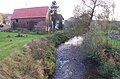
Alsenz within the municipality of the same name
Alsenz weir between Mannweiler and Cölln
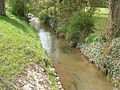
Alsenz in Oberndorf

Bridge over Alsenz and Mühlgraben in Hochstätten


Tributaries
With a catchment area of 65.997 km², the 20.4 km long Moschel is the most water-rich tributary of the Alsenz. It has a share of 20% in the Alsenz catchment area. Other noteworthy tributaries are the Moschelbach and Lohnsbach , whose catchment areas, based on the river length of around 8.5 km, are considerable with 37.329 and 35.324 km², respectively.
In the following, the tributaries of the Alsenz are named in the order from the source to the mouth, which are managed by the Rhineland-Palatinate water management authority. In each case, the orographic position of the mouth, the length, the size of the catchment area, the altitude of the mouth and the river code are given. To make the last one easier to read, a separator (-) has been inserted behind the prefix that is common to all Alsenz tributaries.
| Surname
|
location | Length [km] |
EZG [km²] |
Mouth height [m above sea level NHN ] |
GKZ |
|---|---|---|---|---|---|
| Metzwiesengraben | right | 1.1 | 2.998 | 286 | 2548-112 |
| Hasselbrunnengraben | Left | 3.3 | 5.095 | 272 | 2548-12 |
| Schwarzbach | Left | 3.5 | 9,073 | 270 | 2548-14 |
| Klosterbach | Left | 0.6 | 0.487 | 263 | 2548-152 |
| Hemsbach | right | 4.5 | 11.654 | 259 | 2548-16 |
| Stinkentalbach | Left | 1.1 | 1.674 | 257 | 2548-172 |
| Neumühlenbach | Left | 1.2 | 1.322 | 250 | 2548-174 |
| Münchweiler Bach | Left | 1.2 | 0.993 | 246 | 2548-176 |
| Gonbach | right | 3.4 | 10.268 | 242 | 2548-18 |
| Lohnsbach | Left | 8.7 | 35,324 | 242 | 2548-2 |
| Steinbach | Left | 1.8 | 1.602 | 229 | 2548-32 |
| Imsbach | right | 5.6 | 14,469 | 227 | 2548-4 |
| Zillbach | Left | 1.7 | 1.687 | 224 | 2548-52 |
| Hallergraben | Left | 1.7 | 1,320 | 220 | 2548-54 |
| Moschelbach | Left | 8.6 | 37.329 | 208 | 2548-6 |
| Dörnbach | Left | 5.3 | 8.283 | 207 | 2548-712 |
| Degenbach | right | 2.4 | 3,348 | 202 | 2548-72 |
| Schelmesbach | Left | 2.1 | 2,336 | 194 | 2548-732 |
| Langwaldbach | right | 3.1 | 5.253 | 193 | 2548-74 |
| Dörnbach | right | 1.5 | 1.097 | 193 | 2548-7512 |
| Katzenbach | Left | 2.7 | 4,368 | 189 | 2548-752 |
| Pea dig | right | 2.5 | 2,780 | 189 | 2548-754 |
| Steinmannsgraben | Left | 1.4 | 1.072 | 186 | 2548-756 |
| Rush ditch | right | 2.0 | 4.109 | 181 | 2548-76 |
| Giebelsbach | right | 1.4 | 1.726 | 177 | 2548-772 |
| Kallenbach | Left | 1.5 | 1.623 | 170 | 2548-774 |
| Weidelbach | Left | 1.4 | 0.958 | 166 | 2548-776 |
| Morsbach | right | 3.7 | 6.467 | 158 | 2548-78 |
| Talergraben | right | 2.1 | 3,936 | 151 | 2548-792 |
| Moschel | Left | 20.4 | 65.997 | 145 | 2548-8 |
| Ohlbach | right | 3.4 | 5.316 | 148 | 2548-92 |
| Leischbach | right | 3.3 | 4,549 | 133 | 2548-94 |
| Eilbach | right | 3.0 | 4,430 | 126 | 2548-96 |
Water properties
The Alsenz is a carbonate low mountain range rich in fine material . Your water structure is down to a few sections changed above the local church Alsenz to complete. In the lower reaches, the structure is somewhat better and, apart from the localities, is usually only given as moderately to significantly changed. The water quality is consistently classified as moderately polluted (quality class II, status 2005).
Viticulture
Viticulture on the Alsenz has a long tradition . Even today there are u. a. In Obermoschel , Mannweiler-Cölln , Altenbamberg , Steckweiler , Hochstätten and Steingruben there are still some winegrowers . The vines are mostly on steep slopes up to 60 °. The vineyards belong, although they are in the Palatinate, to the Nahe cultivation area . The German Wine Queen 1966/67 and the Nahe Wine Queen 1984/85 and 1996/97 come from Hochstätten.