
Mannweiler-Cölln
| coat of arms | Germany map | |
|---|---|---|

|
Coordinates: 49 ° 42 ' N , 7 ° 48' E |
|
| Basic data | ||
| State : | Rhineland-Palatinate | |
| County : | Donnersbergkreis | |
| Association municipality : | North Palatinate Country | |
| Height : | 165 m above sea level NHN | |
| Area : | 4.9 km 2 | |
| Residents: | 364 (Dec. 31, 2019) | |
| Population density : | 74 inhabitants per km 2 | |
| Postal code : | 67822 | |
| Area code : | 06362 | |
| License plate : | KIB, ROK | |
| Community key : | 07 3 33 043 | |
| LOCODE : | DE 4JK | |
| Community structure: | 2 districts | |
| Association administration address: | Schulstrasse 16 67821 Alsenz |
|
| Website : | ||
| Local Mayor : | Udo Weyh | |
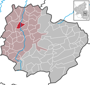
| Location of the local community Mannweiler-Cölln in the Donnersbergkreis | ||
  |
||

Mannweiler-Cölln is a municipality in the Donnersbergkreis in Rhineland-Palatinate . The wine-growing village belongs to the Nordpfälzer Land association, which has its administrative headquarters in the municipality of Rockenhausen and an additional administrative office in Alsenz .
geography
Mannweiler-Cölln is located in the North Palatinate Uplands in the Alsenz valley . Districts are Cölln and Mannweiler . The Morsbacherhof and Weidelbacherhof residential areas also belong to the Cölln district .
To the north is Oberdorf , south Steckweiler .
history
Mannweiler-Cölln was newly formed on June 7, 1969 from the dissolved communities of Mannweiler and Cölln.
Municipal council
The council in mannweiler-cölln consists of eight council members, who in the local elections on May 26, 2019 in a majority vote were elected, and the honorary mayor as chairman.
Local mayor
Local mayor is Udo Weyh. After the local elections in 2019, he was elected in the second meeting of the new municipal council, as there was no successor to Hubert Becker, who had not been a candidate.
Culture and sights
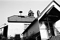
- The Protestant church in Mannweiler-Cölln was built in 1860/61.
- A Catholic chapel room is located in the former Catholic schoolhouse, which was created in 1741 by converting a farmhouse. The half-timbered house has stained glass and is still occasionally used for church services today.
- The Randeck Museum in the former Schultheißenamt and schoolhouse, built in 1748, is a local museum.
- Randeck castle ruins
- Stolzenburg ruins

Protestant Church

Catholic chapel

Morsbacher Hof
Randeck Museum on the Böhl

View from the courtyard of the Walter inn
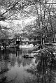
Weir on the Alsenz between Mannweiler and Cölln

Meadow on the Alsenz near Mannweiler

View of the Randeck ruins


Economy and Infrastructure
economy
In Mannweiler-Cölln there is a winery and a production site for the car seat manufacturer Adient .
traffic
The federal highway 48 runs through the village . There is a connection to long-distance traffic via the A 63 in the east.
In Mannweiler there used to be a stop of the Alsenz Valley Railway, today the next train station is in Alsenz .
Sons and daughters of the church
- Walter Giers (1937–2016), artist and one of the pioneers of electronic art
literature
- Dieter Krenke (editing): Mannweiler-Cölln . In: Cultural monuments Rhineland-Palatinate . tape 15 . Wernersche Verlagsgesellschaft, Worms 1998, ISBN 3-88462-153-X , p. 76-84 .
- Literature about Mannweiler-Cölln in the Rhineland-Palatinate state bibliography
Web links
- Local community Mannweiler-Cölln on the website of the Verbandsgemeinde Alsenz-Obermoschel ( Memento from February 21, 2014 in the Internet Archive )
Individual evidence
- ↑ State Statistical Office of Rhineland-Palatinate - population status 2019, districts, communities, association communities ( help on this ).
- ↑ State Statistical Office Rhineland-Palatinate (ed.): Official directory of the municipalities and parts of the municipality. Status: January 2019 [ Version 2020 is available. ] . S. 140 (PDF; 3 MB).
- ↑ Official municipality directory (= State Statistical Office of Rhineland-Palatinate [Hrsg.]: Statistical volumes . Volume 407 ). Bad Ems February 2016, p. 171 (PDF; 2.8 MB).
- ^ The Regional Returning Officer RLP: City Council Election 2019 Mannweiler-Cölln. Retrieved August 27, 2019 .
- ^ Die Rheinpfalz: Mannweiler-Cölln: Wahl still resonates with Kerwe. July 23, 2019, accessed August 27, 2019 .

Albisheim (Pfrimm) | Alsenz | Bayerfeld-Steckweiler | Bennhausen | Biedesheim | Bischheim | Bistiffer | Bolanden | Börrstadt | Breunigweiler | Bubenheim | Dannenfels | Dielkirchen | Dried mussel | Dreisen | Solitude | Eisenberg (Palatinate) | Falkenstein | Finkenbach-Gersweiler | Gauersheim | Gaugrehweiler | Gehrweiler | Gerbach | Göllheim | Gonbach | Gundersweiler | Höringen | Ilbesheim | Immesheim | Imsbach | Imsweiler | Jakobsweiler | Lime kiln | Katzenbach | Candle Home | Kirchheimbolanden | War field | Lautersheim | Pay field | Mannweiler-Cölln | Marnheim | Morschheim | Mörsfeld | Münchweiler an der Alsenz | Münsterappel | Niederhausen an der Appel | Niedermoschel | Oberhausen an der Appel | Upper Muschel | Oberndorf | Oberwiesen | Orbis | Ottersheim | Ramsen | Ransweiler | Rathskirchen | Reichsthal | Rittersheim | Rockenhausen | Ruppertsecken | Rüssingen | Saint Alban | Schiersfeld | Schönborn | Schweisweiler | Souls | Sippersfeld | Sitters | Stahlberg | Standenbühl | Steinbach am Donnersberg | Stetten | Teschenmoschel | Unkenbach | Waldgrehweiler | Wartenberg-Rohrbach | Weitersweiler | Winnweiler | Winterborn | Würzweiler | Zellertal