Steinbach am Donnersberg
| coat of arms | Germany map | |
|---|---|---|

|
Coordinates: 49 ° 36 ' N , 7 ° 57' E |
|
| Basic data | ||
| State : | Rhineland-Palatinate | |
| County : | Donnersbergkreis | |
| Association municipality : | Winnweiler | |
| Height : | 274 m above sea level NHN | |
| Area : | 4.43 km 2 | |
| Residents: | 733 (Dec. 31, 2019) | |
| Population density : | 165 inhabitants per km 2 | |
| Postal code : | 67808 | |
| Area code : | 06357 | |
| License plate : | KIB, ROK | |
| Community key : | 07 3 33 075 | |
| Association administration address: | Jakobstrasse 29 67722 Winnweiler |
|
| Website : | ||
| Mayoress : | Susanne Roess | |
| Location of the local community Steinbach am Donnersberg in the Donnersbergkreis | ||
Steinbach am Donnersberg is a municipality in the Donnersbergkreis in Rhineland-Palatinate . It belongs to the Winnweiler community .
geography
The place is in the North Palatinate Uplands between the Donnersberg in the northwest and the Palatinate Forest in the south. The Wildensteiner Bach flows through the middle of the community and also takes in the Laubbach from the right .
The residential areas Haus Kaiserbusch, Haus Voigtland, Obere Mühle, Rotenbusch and Untere Mühle belong to Steinbach am Donnersberg .
history
Local history
Until the end of the 18th century, Steinbach belonged to a quarter of the Kirchheim and Stauf dominion of the Nassau family and three quarters to Leiningen-Heidesheim .
From 1798 to 1814, when the Palatinate was part of the French Republic (until 1804) and then part of the Napoleonic Empire , the community was incorporated into the French Donnersberg department and the canton of Winnweiler . As a result of the Congress of Vienna in 1815, the place initially belonged to Austria . A year later it was slammed into Bavaria . From 1818 to 1862 Steinbach was part of the Kaiserslautern Land Commissioner , which was then converted into a district office. On December 1, 1900, the community moved to the newly created district office Rockenhausen.
From 1939 the community was part of the Rockenhausen district . After the Second World War , the place became part of the then newly formed state of Rhineland-Palatinate within the French occupation zone . In 1961 the community had a total of 892 inhabitants. In the course of the first administrative reform in Rhineland-Palatinate , Steinbach moved to the newly created Donnersbergkreis on June 7, 1969, together with most of the other places in the district . Three years later the place became part of the Verbandsgemeinde Winnweiler .
origin of the name
The name of the place Steinbach, also called "Schdoabach" by the local population, can be derived from a body of water with this name, as with over 100 of the same place names in German-speaking countries. The eponymous brook of Steinbach am Donnersberg comes from a rocky valley of the Donnersberg . According to a literature citation from 1887, the brook from the Wildensteinertal is called "the Steinbach". The close connection between Steinbach and Standenbühl in the early days also shows a relationship in the name. It was called “Standenböhl” in 1787, “steindte bohell” in 1662, “Steintenbohel” in 1447, “Steinachtenbuel” in 1355 and “Steinchtenbohl” in 1293. According to local researchers, this indicates that the village was initially called "Bohele" in terms of landscape, which means something like Bühel or hill, and later the nickname of the Stan- or Steinbach Stan- or Steintebohl brook. The official spelling "Steinbach am Donnersberg" has been in use since 1907. A document about it bears the date of August 15, 1957. A letter from Jan's State Archives Council dated August 15, 1957 to the district government of the Palatinate in Neustadt shows that the Steinbach comes as a small river from a valley of the Donnersberg.
politics
Municipal council
The council in Steinbach am Donnersberg consists of twelve council members, who in the local elections on May 26, 2019 in a majority vote were elected, and the volunteer local mayor as chairman.
mayor
Local mayor is Susanne Röß. In the local elections on May 26, 2019, she was elected with a share of 74.35% of the vote, succeeding Reiner Bauer, who had not run for this position after ten years in office.
coat of arms
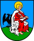
| Blazon : "In blue on a green background, sitting to the left, John the Evangelist in a silver cloak and red petticoat, writing his Gospel in a red-bound silver book,a black eagle standing behind him on the right ." | |
| Founding of the coat of arms: It was awarded in 1950 by the Rhineland-Palatinate Ministry of the Interior and goes back to a seal from 1777. |
Culture and sights
Cultural monuments
The Jewish cemetery is designated as a monument zone . In addition, there are a total of five individual objects that are listed , including the Protestant church .
nature
There are a total of two natural monuments on site .
Celtic village

The Celtic village on Donnersberg is located southwest of the settlement area . The traditionally built court settlement shows handicraft techniques that the Celts used to build houses. There is also an approximately 12-meter-high observation tower , the so-called “Celtic Tower ”, which was partly built by migrant workers without electrical devices.
NABU Celtic Garden
The 6.4 hectare Celtic garden in Steinbach shows life, work, culture and natural space during the Celtic times. There is a triskel playground for children. Display boards provide information about the occurrence and importance of the flora and fauna in the Donnersberg region, but also about agriculture and the culture of the Celts.
Economy and Infrastructure
traffic
The A 63 ( Kaiserslautern - Mainz ) and the old Kaiserstraße run directly southeast of Steinbach .
The nearby Göllheim-Dreisen train station is located on the Zellertal Railway , which lost passenger traffic in 1983 and was only used for excursions from 2001 to 2016. In Winnweiler and Münchweiler an der Alsenz to railway stations are the alsenz valley railway . The Alsenz Valley Railway is operated every hour; in the course book it is listed as KBS 672.
tourism
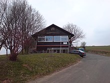
The Steinbacher Hütte is located on the Donnersberg in the municipality .
The European Celtic Route , the Staudernheim-Soultz-sous-Forêts long-distance hiking trail marked with a blue bar and a hiking trail marked with a blue-red bar and which leads from Kirchheimbolanden to Pirmasens run through the village . The Palatinate High Trail also runs through the west of the district .
Personalities
- Samuel Köster (1742–1829), Protestant pastor and Jacobin, was the local pastor from 1769 to 1780
- Gustav Adolf Bernd (1869–1942), sculptor and stonemason, created the local war memorial
literature
- CE Gross: The Donnersberg. 1887.
- Michael März: Heimatbuch from 1990 for the 800th anniversary of Steinbach am Donnersberg.
Web links
- Private website of the local community Steinbach am Donnersberg
- Portal with excerpts from the book for the 800 year celebration
- Celtic garden in Steinbach am Donnersberg
- Open-air museum Keltendorf am Donnersberg
- Literature about Steinbach am Donnersberg in the Rhineland-Palatinate state bibliography
Individual evidence
- ↑ State Statistical Office of Rhineland-Palatinate - population status 2019, districts, communities, association communities ( help on this ).
- ↑ State Statistical Office Rhineland-Palatinate (ed.): Official directory of the municipalities and parts of the municipality. Status: January 2019 [ Version 2020 is available. ] . S. 145 (PDF; 3 MB).
- ^ The Regional Returning Officer Rhineland-Palatinate: Local council election 2019 Steinbach. Retrieved September 2, 2019 .
- ↑ The Regional Returning Officer Rhineland-Palatinate: direct elections 2019. Retrieved on September 2, 2019 (see Winnweiler, Verbandsgemeinde, eleventh line of results).
- ^ Winnweiler Rundschau, Official Gazette of the Verbandsgemeinde: Reiner Bauer and Michael March honored. Edition 26/2019, official part. Retrieved September 2, 2019 .


