
Candle Home
| coat of arms | Germany map | |
|---|---|---|

|
Coordinates: 49 ° 35 ' N , 8 ° 4' E |
|
| Basic data | ||
| State : | Rhineland-Palatinate | |
| County : | Donnersbergkreis | |
| Association municipality : | Eisenberg (Palatinate) | |
| Height : | 201 m above sea level NHN | |
| Area : | 17.88 km 2 | |
| Residents: | 2078 (Dec. 31, 2019) | |
| Population density : | 116 inhabitants per km 2 | |
| Postal code : | 67304 | |
| Area code : | 06351 | |
| License plate : | KIB, ROK | |
| Community key : | 07 3 33 038 | |
| Association administration address: | Hauptstrasse 86 67304 Eisenberg (Palatinate) |
|
| Website : | ||
| Mayoress : | Andrea Schmitt ( CDU ) | |
| Location of the local community in Kerzenheim in the Donnersbergkreis | ||
  |
||

In terms of population, Kerzenheim is the seventh largest local community in the Donnersbergkreis in Rhineland-Palatinate . It belongs to the Eisenberg (Palatinate) community , within which it is the smallest local community in terms of area.
geography
location
Candle home is located on the northern edge of the Palatinate Forest and its sub-area Stumpwald , which belongs to the higher-level unit of the Lower Palatinate Forest . Just north and east of the partially to the already closes Alzeyer hills add projected Eisenberger pool to. Both belong to the superordinate unit " Rheinhessisches Tafel- und Hügelland ". The latter and the Palatinate Forest flow into one another on the municipal marker.
To the west lies the Rosenthal district , named after the Rosenthal Abbey , which is divided into the villages of Göllheimer Häuschen , Grauwald-Siedlung, Kerzweilerhof, Rosenthalerhof and Steinäcker-Siedlung. The Arles-Siedlung and Haus Dietrich residential areas also belong to Kerzenheim .
Neighboring communities are - clockwise - Göllheim , Lautersheim , Ebertsheim , Eisenberg , Ramsen , Enkenbach-Alsenborn , Sippersfeld and Breunigweiler .
Surveys
The highest elevations of the community are in the west of the municipality in the Palatinate Forest. The 377.1 m high Pfrimmerberg rises in the southwest of the district on the border with Sippersfeld . The 366 m high Kühberg extends on the border to Eisenberg . The 353 m high Salweidenkopf is located in the district triangle to Enkenbach-Alsenborn and Ramsen . The Esper , which is located in the east on the boundary of Lautersheim and measures 309 m , is already part of the Alzeyer hill country .
Waters
The Rodenbach, which runs in a west-east direction, rises at the Rosenthalerhof and flows through the Rosenthaler Weiher ; then it runs south of the settlement area of the core municipality. In the middle of the latter, the Kerzenheimer Bach flows , which then flows into the Rodenbach from the left , as does the Stehrbach , which flows east of the core municipality in a north-south direction .
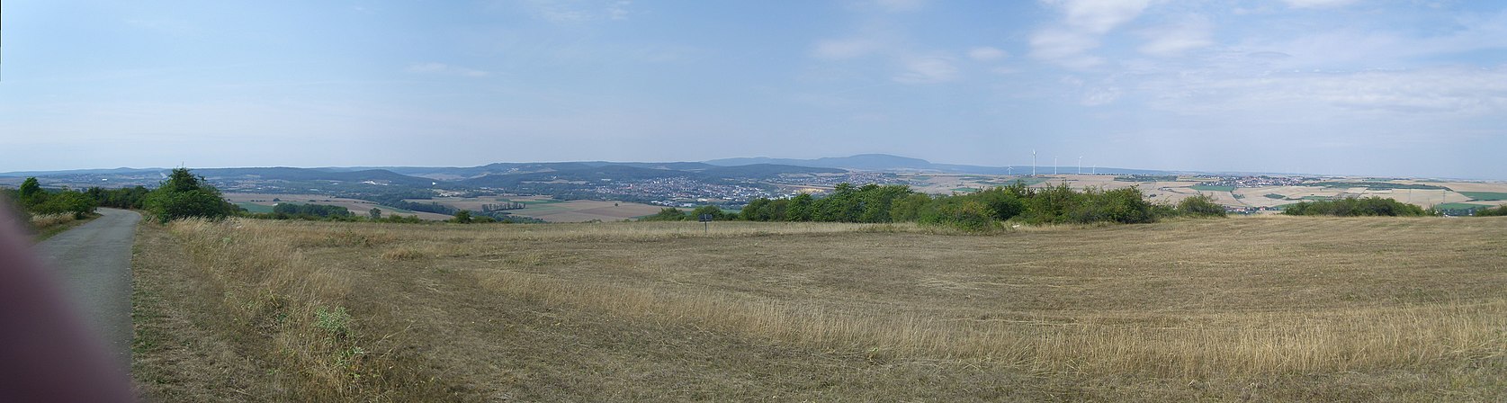
View from the Grünstadter Berg to the Eisenberg Basin with Eisenberg and Kerzenheim; to the right behind the Donnersberg
.jpg)
history

There are several indications that the demarcation was already settled in Roman times . In the middle of the 19th century, a Dianar relief from around 200 AD was found next to the road towards Göllheim . This formed part of a four-god stone and came from the base of a giant column of Jupiter . It came to the Palatinate Historical Museum in Speyer in 1875 and is shown there in the Roman collection.
The first written mention of the place as Kentzenheim took place in 1143, in 1194 and 1198 it was called Chercenheim . The place name is possibly derived from a personal name Kernzo . Until the middle of the 13th century, the community was owned by the Höningen monastery .
Until the end of the 18th century, the place then belonged to Nassau-Weilburg ; there he was under the rule of Kirchheim and Stauf, founded in 1388 . From 1798 to 1814, when the Palatinate was part of the French Republic (until 1804) and then the Napoleonic Empire , Kertzenheim belonged - as it was spelled at the time - to the canton of Göllheim and was the seat of its own mairie , which also included Rodenbach and Lautersheim . In 1815 it was added to Austria . Just one year later, the place, like the entire Palatinate, changed to the Kingdom of Bavaria . From 1818 to 1862 candle home belonged to the Landkommissariat Kirchheim - later Kirchheimbolanden - to; from this the district office of Kirchheimbolanden emerged.
From 1939 the place was part of the Kirchheimbolanden district . After the Second World War , Kerzenheim became part of the then newly formed state of Rhineland-Palatinate within the French occupation zone . In the course of the first Rhineland-Palatinate administrative reform in 1969, Kerzenheim moved to the newly formed Donnersbergkreis ; three years later the community was incorporated into the also newly formed Eisenberg (Palatinate) community . In 1989 the local district "Rosenthal" was newly formed from the settlements located in the west of the municipality.
population
Population development
The development of the population of the community in Kerzenheim, the values from 1871 to 1987 are based on censuses:
|
|
|
religion
- Christianity
The St. Remigius monastery once existed in the area of the Rosenthal district . On the catholic side, the community belongs to the diocese of Speyer and is subordinate to the dean's office in Bad Dürkheim , the Evangelicals to the Protestant regional church of the Palatinate . In 1928, on the Catholic side, candle home belonged to the parish of Göllheim and to the dean's office in Kirchheimbolanden. Later it formed a branch of Eisenberg and belonged to the parish community of Grünstadt . On January 1st, 2016, on the Catholic side, Kerzenheim has been part of the parish of St. Luke , based in Hettenleidelheim . In addition, the congregation was the location of a New Apostolic Church that was divorced in 2014.
- Judaism
There was once a local Jewish community whose members were buried in Göllheim .
politics
Municipal council
The municipal council in Kerzenheim consists of 16 council members who were elected in a personalized proportional representation in the local elections on May 26, 2019 , and the honorary local mayor as chairman.
The distribution of seats in the municipal council:
| choice | SPD | CDU | GREEN | FWG | total |
|---|---|---|---|---|---|
| 2019 | 8th | 3 | 1 | 4th | 16 seats |
| 2014 | 10 | 1 | 1 | 4th | 16 seats |
| 2009 | 11 | 1 | - | 4th | 16 seats |
| 2004 | 10 | 2 | - | 4th | 16 seats |
- FWG = Free Voting Group of the Verbandsgemeinde Eisenberg (Pfalz) e. V.
mayor
The local mayor is Andrea Schmitt from the CDU. In the local elections on May 26, 2019, she was elected with a share of the vote of 50.04 percent; this corresponds to the lead of one vote. She is the successor to Alfred Wöllner (SPD), who did not run after 20 years in office.
coat of arms
|
|
Blazon : “Split by silver and blue. On the right above a green mountain in the base of a shield a red church with a Gothic bell tower accompanied by a floating blue shield with a silver rose inside. On the left the silver letter K. " |
| Justification for the coat of arms: The church in the coat of arms and the rose refer to the Rosenthal monastery located in the municipality |
Culture
Cultural monuments

The Ebert Strasse , the Göllheimer road and lying to the west of the district former monastery Rosenthal in the district rose Thalerhof are as monument zones reported. The first two include several half-timbered houses from the 18th century. The monastery was founded in 1241 by Count Eberhard II von Eberstein .
In addition, there are a total of 13 individual objects that are under monument protection , including the former council and school building and the courtyard with the address Eisenberger Straße 3 . In 1783 a new Lutheran parish church was built, a significant Lutheran central church building by Johann Georg Christian Hess , a representative of classicism .
nature
The west of the district lies in the Palatinate Forest Nature Park , which in turn is part of the Palatinate Forest-Vosges du Nord Biosphere Reserve . The only natural monument on site is an ensemble of trees at the Rosenthalerhof.
regional customs
Among other things, there is an allotment gardening association on site. On the Sunday before the beginning of spring, it organizes the annual Stabaus .
Economy and Infrastructure
economy
At the western edge of the settlement there were pits in late Roman times in which iron was mined. 1997 closed also existed on site Regency Net Communications Facility Kerzenheim the US Army . In the north-east of the municipality is the wind farm Kerzenheim , which went into operation from 1999 to 2015 , and which is already partly in the Göllheim district.
traffic

Candle home is on the B 47 , from which the state road 449 , which runs via Göllheim to Marnheim , branches off. The state road 452 leads to Ebertsheim. The state road 396 , which runs in the west of the district, passes the hamlet of Göllheimer Häuschen. The district road 76 creates a connection to Steinborn . The county road 78 connects the local district Rosenthal to the road network.
The A 63 in the north and the A 6 in the south are just a short distance away . The closest train station is Eisenberg (Pfalz) train station on the Eistalbahn .
leisure
There is a sports field on site.
tourism
The Staudernheim-Soultz-sous-Forêts long-distance hiking trail marked with a blue bar runs through the west of the district , a hiking trail marked with a yellow bar and one marked with a blue-red bar and from Kirchheimbolanden to Pirmasens leads. Another is marked with a green-blue bar and runs from Göllheim to Eppenbrunn .
Personalities

Sons and daughters of the church
- Anton Foohs (1871–1940), prelate, Bavarian divisional pastor in World War I , founder of the Palatinate Catholic Day in St. John's Cross
- Forbesia Erhard (1892-1963), from 1929 to 1936 as a kindergarten teacher, nurse and geriatric nurse in Astheim active
- Leonhard Wüchner (1895 – after 1938), politician (NSDAP)
People who worked on site
- Eberhard IV von Eberstein († 1263), founder of the Rosenthal Monastery, buried there; Grave slab preserved in the church ruins
- Raugraf Heinrich I († 1261), nobleman, nephew of the founder of the Rosenthal monastery, was one of the main characters in the deadly jealous drama about Duchess Maria von Brabant . He was buried in the Rosenthal monastery; the tombstone was preserved there.
- Anna von Lustadt († 1485), abbess of the Rosenthal monastery, lived and died there; Grave slab preserved in the church ruins
- Margaretha von Venningen († 1505), abbess of the Rosenthal monastery, lived and died there
- Barbara Göler von Ravensburg († 1535), abbess of the Rosenthal monastery, lived and died there; Grave slab preserved in the church ruins
- Barbara von Heppenheim called vom Saal († 1567), abbess of the Rosenthal monastery, lived and died there; Grave slab preserved in the church ruins
- Johann Georg Christian Hess (1756–1816), architect, designed the local Protestant church
- Johann Jakob Ritterspach , 1792/93 member of the Rhine-German National Convention
- Johann Georg Lehmann (1797–1876), pastor and historian, became a pastor in Kerzenheim in 1840
- Johann Schiller (1812–1886), pastor, theologian and writer, took over a position as private tutor for the local pastor in 1835
Web links
- The local community in Kerzenheim on the website of the Eisenberg (Palatinate) community
- Literature about candles home in the Rhineland-Palatinate state bibliography
Individual evidence
- ↑ a b State Statistical Office of Rhineland-Palatinate - population status 2019, districts, municipalities, association communities ( help on this ).
- ↑ Main statute of the local community in Kerzenheim ( Memento from May 20, 2016 in the Internet Archive ) (PDF; 28 kB)
- ↑ State Statistical Office Rhineland-Palatinate (ed.): Official directory of the municipalities and parts of the municipality. Status: January 2019 [ Version 2020 is available. ] . S. 141 (PDF; 3 MB).
- ↑ Digital scan of the find . In: Communications of the Historical Association of the Palatinate . 1876, p. 151 ff . ( Online [accessed April 10, 2020]).
- ↑ Rheinische Vierteljahrsblätter , Volume 65, Röhrscheid, 2001, p. 177 ( Google Books )
- ↑ State Statistical Office Rhineland-Palatinate: My village, my city. Retrieved February 18, 2020 .
- ↑ daten.digitale-sammlungen.de: List of localities for the Free State of Bavaria . Retrieved April 10, 2020 .
- ↑ pfarrei-feilbingert.de: future structure of the diocese of Speyer . Retrieved April 10, 2020 .
- ^ The Regional Returning Officer Rhineland-Palatinate: Municipal Council Election 2019 Candle Home. Retrieved September 1, 2019 .
- ↑ The Regional Returning Officer Rhineland-Palatinate: direct elections 2019. Accessed on September 1, 2019 (see Eisenberg (Palatinate), Verbandsgemeinde, fourth line of results).
- ↑ SPD wants to be constructive. In: The Rhine Palatinate. June 8, 2019, accessed September 1, 2019 .

Albisheim (Pfrimm) | Alsenz | Bayerfeld-Steckweiler | Bennhausen | Biedesheim | Bischheim | Bistiffer | Bolanden | Börrstadt | Breunigweiler | Bubenheim | Dannenfels | Dielkirchen | Dried mussel | Dreisen | Solitude | Eisenberg (Palatinate) | Falkenstein | Finkenbach-Gersweiler | Gauersheim | Gaugrehweiler | Gehrweiler | Gerbach | Göllheim | Gonbach | Gundersweiler | Höringen | Ilbesheim | Immesheim | Imsbach | Imsweiler | Jakobsweiler | Lime kiln | Katzenbach | Candle Home | Kirchheimbolanden | War field | Lautersheim | Pay field | Mannweiler-Cölln | Marnheim | Morschheim | Mörsfeld | Münchweiler an der Alsenz | Münsterappel | Niederhausen an der Appel | Niedermoschel | Oberhausen an der Appel | Upper Muschel | Oberndorf | Oberwiesen | Orbis | Ottersheim | Ramsen | Ransweiler | Rathskirchen | Reichsthal | Rittersheim | Rockenhausen | Ruppertsecken | Rüssingen | Saint Alban | Schiersfeld | Schönborn | Schweisweiler | Souls | Sippersfeld | Sitters | Stahlberg | Standenbühl | Steinbach am Donnersberg | Stetten | Teschenmoschel | Unkenbach | Waldgrehweiler | Wartenberg-Rohrbach | Weitersweiler | Winnweiler | Winterborn | Würzweiler | Zellertal