
Stahlberg
| coat of arms | Germany map | |
|---|---|---|

|
Coordinates: 49 ° 40 ' N , 7 ° 47' E |
|
| Basic data | ||
| State : | Rhineland-Palatinate | |
| County : | Donnersbergkreis | |
| Association municipality : | North Palatinate Country | |
| Height : | 403 m above sea level NHN | |
| Area : | 2.59 km 2 | |
| Residents: | 172 (Dec. 31, 2019) | |
| Population density : | 66 inhabitants per km 2 | |
| Postal code : | 67808 | |
| Area code : | 06361 | |
| License plate : | KIB, ROK | |
| Community key : | 07 3 33 073 | |
| Association administration address: | Bezirksamtsstrasse 7 67806 Rockenhausen |
|
| Website : | ||
| Local Mayor : | Bernd Wirth | |
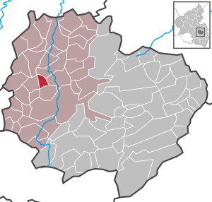
| Location of the local community Stahlberg in the Donnersbergkreis | ||
  |
||

The local community Stahlberg is located in the Donnersbergkreis in Rhineland-Palatinate . It belongs to the Verbandsgemeinde Nordpfälzer Land , within which it is the fourth smallest in terms of area and the eighth smallest in terms of population.
geography
location
The place is located in the North Palatinate Uplands northwest of the Donnersberg between Kaiserslautern and Bad Kreuznach . 73 percent of the district area is forested. The eponymous mountain is 488.6 meters high and is located in the southern municipality on the border with Katzenbach. The Forsthaus Stahlberg residential area also belongs to the community . Neighboring communities are - clockwise - Bayerfeld-Steckweiler , Dielkirchen , Katzenbach , Ransweiler and Schiersfeld .
geology
The Moschellandsbergite occurs in the municipality .
history
From 1782 to the end of the 18th century Stahlberg belonged to the Upper Austrian Upper Office of Winnweiler .
After the French Revolution , when the Palatinate was part of the French Republic (until 1804) and then part of the Napoleonic Empire , the municipality was incorporated into the canton of Rockenhausen and the Donnersberg department . As a result of the Congress of Vienna , the place belonged again to Austria in 1815 . A year later it was slammed into Bavaria . From 1818 to 1862 Stahlberg was part of the Kirchheim Land Commissioner , which was then converted into a district office. On December 1, 1900, the community moved to the newly created district office Rockenhausen
From 1939 the place was part of the district of Rockenhausen . After the Second World War , Stahlberg was part of the French occupation zone and was incorporated into the newly formed state of Rhineland-Palatinate in 1946. In the course of the first Rhineland-Palatinate administrative reform , the community moved to the newly created Donnersbergkreis. In 1972 it was added to the newly formed community of Rockenhausen . Stahlberg has been part of the Nordpfälzer Land association since 2020 .
politics
Municipal council
The municipal council in Stahlberg consists of six council members, who were elected by majority vote in the local elections on May 26, 2019 , and the honorary local mayor as chairman.
Local mayor
Local mayor is Bernd Wirth. In the local elections on May 26, 2019, he was elected with a share of 53.54% of the vote and prevailed with seven votes ahead of the previous incumbent Karlheinz Fisch.
coat of arms
|
|
Blazon : “In silver, three natural green mountain peaks; on the right elevated by a floating blue element symbol for mercury , on the left elevated by floating crossed black mallets and irons. " |
Cultural monuments

There are two objects on site that are listed , including the Langenstein .
Economy and Infrastructure
economy
In 1390, Count von Veldenz was already digging for silver on the Stahlberg, which had been mined there since the end of the previous century. The pits extended over the entire municipality.
traffic
The state road 385 touches the extreme north of the municipality marker. The district road 14 that branches off from this connects the settlement area to the road network. Bundesstraße 48 runs east of Stahlberg . There is a connection to long-distance traffic via the A 63 in the southeast.
Local traffic was organized in the West Palatinate Transport Association (WVV) from 2000 , which has been fully integrated into the Rhein-Neckar Transport Association (VRN) since summer 2006 . In Rockenhausen there is a train station for the Alsenz Valley Railway . The 913 bus operated by Behles Bus , which runs north to Schiersfeld, leads from Stahlberg .
tourism
The Palatinate High Trail and the Nahegau-Wasgau-Vosges long-distance hiking trail marked with a white cross run through Stahlberg .
Personalities
- Johann Gottfried Steinhäuser (1768–1825), physicist, mathematician, mining specialist and lawyer, visited the local mercury mines towards the end of the 18th century
literature
- Literature about Stahlberg in the Rhineland-Palatinate State Bibliography
Web links
Individual evidence
- ↑ State Statistical Office of Rhineland-Palatinate - population status 2019, districts, communities, association communities ( help on this ).
- ↑ State Statistical Office Rhineland-Palatinate (ed.): Official directory of the municipalities and parts of the municipality. Status: January 1, 2017 [ Version 2020 is available. ] . S. 91 (PDF; 1.9 MB).
- ^ The Regional Returning Officer RLP: City Council Election 2019 Stahlberg. Retrieved August 25, 2019 .
- ^ The regional returning officer RLP: direct elections 2019. see Nordpfälzer Land, Verbandsgemeinde, 28th line of results. Retrieved August 25, 2019 .
- ↑ The Rheinpfalz: Stahlberg now with women power. August 2, 2019, accessed August 25, 2019 .

Albisheim (Pfrimm) | Alsenz | Bayerfeld-Steckweiler | Bennhausen | Biedesheim | Bischheim | Bistiffer | Bolanden | Börrstadt | Breunigweiler | Bubenheim | Dannenfels | Dielkirchen | Dried mussel | Dreisen | Solitude | Eisenberg (Palatinate) | Falkenstein | Finkenbach-Gersweiler | Gauersheim | Gaugrehweiler | Gehrweiler | Gerbach | Göllheim | Gonbach | Gundersweiler | Höringen | Ilbesheim | Immesheim | Imsbach | Imsweiler | Jakobsweiler | Lime kiln | Katzenbach | Candle Home | Kirchheimbolanden | War field | Lautersheim | Pay field | Mannweiler-Cölln | Marnheim | Morschheim | Mörsfeld | Münchweiler an der Alsenz | Münsterappel | Niederhausen an der Appel | Niedermoschel | Oberhausen an der Appel | Upper Muschel | Oberndorf | Oberwiesen | Orbis | Ottersheim | Ramsen | Ransweiler | Rathskirchen | Reichsthal | Rittersheim | Rockenhausen | Ruppertsecken | Rüssingen | Saint Alban | Schiersfeld | Schönborn | Schweisweiler | Souls | Sippersfeld | Sitters | Stahlberg | Standenbühl | Steinbach am Donnersberg | Stetten | Teschenmoschel | Unkenbach | Waldgrehweiler | Wartenberg-Rohrbach | Weitersweiler | Winnweiler | Winterborn | Würzweiler | Zellertal