Oberhausen an der Appel
| coat of arms | Germany map | |
|---|---|---|

|
Coordinates: 49 ° 43 ' N , 7 ° 52' E |
|
| Basic data | ||
| State : | Rhineland-Palatinate | |
| County : | Donnersbergkreis | |
| Association municipality : | North Palatinate Country | |
| Height : | 210 m above sea level NHN | |
| Area : | 3.34 km 2 | |
| Residents: | 162 (Dec. 31, 2019) | |
| Population density : | 49 inhabitants per km 2 | |
| Postal code : | 67822 | |
| Area code : | 06362 | |
| License plate : | KIB, ROK | |
| Community key : | 07 3 33 053 | |
| Association administration address: | Schulstrasse 16 67821 Alsenz |
|
| Website : | ||
| Local Mayor : | Klaus Glass | |
| Location of the local community Oberhausen an der Appel in the Donnersbergkreis | ||
Oberhausen an der Appel is a municipality in the Donnersbergkreis in Rhineland-Palatinate . It belongs to the Verbandsgemeinde Nordpfälzer Land , which has its administrative headquarters in the municipality of Rockenhausen and an additional administrative office in Alsenz .
geography
Oberhausen is located in the North Palatinate Uplands . To the north is Münsterappel , east battlefield , in the West Alsenz and south is Gaugrehweiler . The closest cities are Bad Kreuznach , Rockenhausen and Kaiserslautern .
The Appelbach flows through the municipality . On site, it takes in the Gutenbach from the right , alternatively called Kallenbach .
history
Oberhausen was first mentioned in a certificate from Otto the Great dated June 4, 940. During the time of the tribal duchies, the place was in the Duchy of Franconia . In the Thirty Years War Oberhausen lost all residents. Only in the second half of the 17th century did new life come into the community. Until 1708 the place belonged to the County of Sponheim and was there under the Oberamt Kreuznach . At the end of the 18th century the place belonged to the Electoral Palatinate .
From 1798 to 1814, when the Palatinate was part of the French Republic (until 1804) and then part of the Napoleonic Empire , the community was incorporated into the canton of Obermoschel and was under the Mairie Niederhausen . In 1815 the place had 173 inhabitants. In the same year the place belonged again to Austria . A year later it was slammed into Bavaria . From 1818 to 1862 Ober-Hausen was - as it was spelled at the time - part of the Kirchheim Land Commissioner , which was then converted into a district office.
On December 1, 1900, the community moved to the newly created district office Rockenhausen . From 1939 the place was part of the district of Rockenhausen . After the Second World War , Steingruben became part of the then newly formed state of Rhineland-Palatinate within the French occupation zone . In 1961 the community had a total of 241 inhabitants. In the course of the first Rhineland-Palatinate administrative reform , the community moved to the newly created Donnersbergkreis. In 1972 it was added to the newly formed community of Alsenz-Obermoschel . Oberhausen has been part of the Nordpfälzer Land association since 2020 .
religion
The Jews living in the village were buried in Münsterappel .
politics
Municipal council
The municipal council in Oberhausen consists of six council members, who were elected by a majority vote in the local elections on May 26, 2019 , and the honorary local mayor as chairman. The turnout was 66.4% (2014: 63.3%).
Local mayor
The local mayor is Klaus Glass. After the local elections in 2019, he was unanimously elected in the constituent meeting of the local council and thus succeeded Thomas Dinges, who had no longer stood as a candidate.
coat of arms
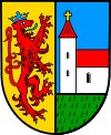
| Blazon : "Split of gold and blue, on the right a red lion, tongued, reinforced and crowned, on the left above a green shield base a silver church, roofed in red and with a golden tower cross." | |
Culture and sights
Cultural monuments
The Borngasse is a conservation zone reported. In addition, there are a total of six individual objects that are listed , including the former school building.
nature
The only natural monument on site are the eight sparrows .
Economy and Infrastructure
economy
From 1830 to 1910 the Oberhausen quarries had a boom. Many sandstone facades in the region date from this time, including the bridge over the Appelbach. The Alsenz wind farm , which was built between 199 and 2017, partially extends over the area of the local community.
traffic
Roads 399 and 400 intersect in the village . The former establishes a connection to Kirchheimbolanden and the latter to Wöllstein and Rockenhausen. There is a connection to long-distance traffic via the A 63 in the east and the A 61 in the northeast. By Gaugrehweiler of lead Behles bus operated bus lines 902 and 914. Nearest station is Alsenz at the alsenz valley railway .
tourism
The Appelbach cycle path and the Donnersberg-Donon long-distance hiking trail marked with a red bar also lead through Gaugrehweiler .
literature
- Literature about Oberhausen an der Appel in the Rhineland-Palatinate state bibliography
Web links
- Local community of Oberhausen an der Appel
- Local community Oberhausen an der Appel on the website of the Verbandsgemeinde Alsenz-Obermoschel
Individual evidence
- ↑ State Statistical Office of Rhineland-Palatinate - population status 2019, districts, communities, association communities ( help on this ).
- ^ The Regional Returning Officer Rhineland-Palatinate: Local elections 2019, city and municipal council elections
- ^ Die Rheinpfalz: Mayoral election: Klaus Glass succeeds Thomas Dinges. July 1, 2019, accessed August 29, 2019 .


