
Goellheim
| coat of arms | Germany map | |
|---|---|---|

|
Coordinates: 49 ° 36 ' N , 8 ° 3' E |
|
| Basic data | ||
| State : | Rhineland-Palatinate | |
| County : | Donnersbergkreis | |
| Association municipality : | Goellheim | |
| Height : | 244 m above sea level NHN | |
| Area : | 18.02 km 2 | |
| Residents: | 3857 (Dec. 31, 2019) | |
| Population density : | 214 inhabitants per km 2 | |
| Postal code : | 67307 | |
| Area code : | 06351 | |
| License plate : | KIB, ROK | |
| Community key : | 07 3 33 026 | |
| LOCODE : | DE 83Z | |
| Association administration address: | Freiherr-vom-Stein-Strasse 1–3 67307 Göllheim |
|
| Website : | ||
| Local Mayor : | Dieter Hartmüller ( CDU ) | |
| Location of the local community of Göllheim in the Donnersbergkreis | ||
  |
||


Göllheim is the fifth largest municipality in terms of population in the Donnersbergkreis in Rhineland-Palatinate . It is the administrative seat of the association of the same name , to which it also belongs. According to state planning, Göllheim is designated as a basic center.
geography
location
Göllheim is located in the Palatinate between the Göllheim hill country, which is part of the Rheinhessisches Tafel- und Hügelland, and the Kaiserstraßensenke . The extreme west of the district extends to the northern foothills of the Palatinate Forest , which are part of the Stumpfwald sub-area and form the so-called Göllheimer Wald . Göllheim also includes the Am Ruhweg, Auf der Füllenweide , Esper and Gundheimerhof residential spaces . Neighboring communities are - in clockwise direction - Marnheim , Rüssingen , Biedesheim , Lautersheim , Lampenheim , Breunigweiler , Börrstadt and Dreisen .
Elevations and waters
Immediately to the west of the settlement area is the Hasenbühl and to the southwest, on the border with Kerzenheim, the Kriegsberg . In the north, not far from the border with Marnheim, is the 300.9 meter high mountain Hohe Benn .
In the northwest, the Hasenbach partially forms the border with Dreisen. The Mohrbach rises in the far east .
climate
The long-term average annual precipitation is around 556 millimeters. The rainfall is low. They are in the lower quarter of the values recorded in Germany. Lower values are registered at twelve percent of the measuring stations of the German Weather Service . The driest month is January, the most precipitation falls in July. In July there is 1.6 times more rainfall than in January. Precipitation varies only minimally and is evenly distributed over the year. Lower seasonal fluctuations are recorded at just four percent of the measuring stations .
The company Meteomedia operates a weather station on site. The community and the Donnersberg local group of the Pollichia association participated in the financing . The station's data are displayed on an electronic display near the town hall. They are also included in the weather report, which is presented daily by the company on the TV programs of ARD and SWR3 .

View of Göllheim from the east, in the background the Donnersberg

history
Early history and antiquity

The place was first mentioned in the year 819 as Gylnheim , but people have settled here for several thousand years, as evidence within the place and the entire district prove. For example, arrowheads, knives and scrapers from the Neolithic period were found . In the area of the Füllenweide settlement there are two large burial mound fields that are estimated to date from around 700 BC.
Various settlements on the southern slope of the Mohrbach are known from Roman times. In 1924 a mighty stone coffin with a skeleton was found. Based on the additions, it is dated to the transition from the third to the fourth century. There is also evidence of a Roman villa on the basis of other artifacts.
Again in the area of Füllenweide there are copper and iron ore mines that were exploited by Roman settlers. In 1916 individual shafts were rediscovered and explored.
middle Ages

The place was also settled in Franconian times, as evidenced by an extensive burial ground with numerous grave goods from the sixth to seventh centuries in the southeast of the place. The place name Göllheim refers to the Franks , more precisely to a Franconian named Gilo: "Göll - Heim", "Gyln - Heim", "Gilo = Heim", corresponding to "Heim des Gilo".
Emperor Ludwig the Pious was allegedly staying in a local royal court on April 1, 828 and presumably sealed a document. However, it is difficult to prove an imperial stay and the royal court based on preserved files and finds; for the near Albisheim, however, definitely testified.

In the Middle Ages Göllheim belonged to the Stauf rule . After the Hohenstaufen dynasty died out around 1200, the Counts of Eberstein acquired their property through marriage. In the 13th century, the Göllheim church was donated to the Rosenthal monastery in 1247 by Eberhard IV von Eberstein and his wife Adelheid. The stone heraldic rose of the Ebersteiner and Rosenthal monastery above a Gothic window in the basement tower of the Protestant church still reminds of this donation and the affiliation to the monastery. Again by marriage, the entire rule came to the Counts of Zweibrücken .
On July 2, 1298, the Knight's Battle at Göllheim - alternatively known as the "Battle of the Hasenbühl" - an important event in the medieval history of the empire, in which the Roman-German King Adolf von Nassau fell. The battle was the end of the battle between Adolf von Nassau and Albrecht I of Austria for the royal dignity of the Holy Roman Empire . The King's Cross stands at Adolf's place of death, which is now located within the settlement area . It is the oldest field cross in the Palatinate and was built over with a protective chapel according to plans by August von Voit in the 19th century .
In the same year 1298, after the battle, the Graf brothers Eberhard I. and handed Walram I . from Zweibrücken village and court Göllheim to the Worms bishop Emich . Belonging to the Hochstift Worms did not even last 100 years, because between 1378 and 1388 Count Heinrich II. Von Sponheim -Dannenfels gradually bought the Stauf estate.
But already in 1393 it came - again through marriage - into the possession of Philip I of Nassau-Saarbrücken .
Modern times
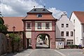
The town was fortified in the first half of the 15th century. Whether exclusively with walls and ditches or even a wall is not completely clear. In any case, the place had several gates and watchtowers; of which the Kerzenheimer and Dreisener Tor, as well as the Ullrichsturm are left. The course of the medieval fortifications can still be seen on aerial photographs around the old town center.
Göllheim remained with the Nassau family until the upheavals that followed the French Revolution at the end of the 18th century; initially ruled jointly by both Nassau-Saarbrücken and Nassau Weilburg lines, after the Nassau-Saarbrücken line died out in 1574, it was dominated by Nassau-Weilburg alone. The introduction of the Reformation at the beginning of the 16th century was made more difficult or difficult by this fact of the division of power. dragged on for several decades: because Saarbrücken remained Catholic, Weilburg switched to Protestantism.

Up until the French Revolution, Göllheim was the seat of an office in the County of Nassau-Weilburg . In 1798 Göllheim became the capital of a canton of the same name in the Donnersberg department under French rule. In 1815 the place had a total of 1137 inhabitants. Due to the agreements made at the Congress of Vienna in 1815 and an exchange contract with Austria , the region became part of the Kingdom of Bavaria in 1816 . From 1818 to 1862 Eisenberg belonged to the Land Commissioner Kirchheim , later Kirchhheimbolanden ; from this the district office of Kirchhheimbolanden emerged.
From 1939 the place was part of the Kirchheimbolanden district . After the Second World War , Göllheim became part of the then newly formed state of Rhineland-Palatinate within the French occupation zone . In the course of the first administrative reform in Rhineland-Palatinate , Göllheim moved to the newly formed Donnersbergkreis in 1969 ; three years later, the municipality became the administrative seat of the also newly created association municipality of the same name .
religion
There was also a Jewish community in Göllheim in the Middle Ages. The Judengasse in the old town center, a badly weathered Judensau on the northwest corner of the Protestant church tower, which points towards the Judengasse, and two Jewish cemeteries still bear witness to it today . The older, now abandoned, is now only recognizable by its square, tree-covered base and is located in the middle of fields. The newer one is located directly on the road to the Göllheimer Wald in the direction of Göllheimer Häuschen and Ramsen . The synagogue of the Jewish community was desecrated and devastated during the November pogroms in 1938 , as were Jewish shops, and the building was demolished in 1971. In the meantime, a plaque commemorates the synagogue at the former location.
politics
Municipal council
The municipal council in Göllheim consists of 20 council members, who were elected in a personalized proportional representation in the local elections on May 26, 2019 , and the honorary local mayor as chairman.
The distribution of seats in the municipal council:
| choice | SPD | CDU | GREEN | FWG | total |
|---|---|---|---|---|---|
| 2019 | - | 11 | 3 | 6th | 20 seats |
| 2014 | - | 11 | 3 | 6th | 20 seats |
| 2009 | 3 | 8th | 1 | 8th | 20 seats |
| 2004 | 4th | 7th | 1 | 8th | 20 seats |
- FWG = Free Voters Göllheim e. V.
mayor
Dieter Hartmüller has been mayor of the CDU since 2009 . His predecessor was Hans Appel from the FWG, who had held the office since 1964.
coat of arms
|
|
Blazon : "In blue a silver lily girdled with gold." |
Community partnerships
| local community | country | since |
|---|---|---|
| La Clayette | France | 1977 |
| Marano Equo | Italy | 1990 |
Culture and sights
Cultural monuments
The town center, the Christian cemetery, the house ensembles Hauptstrasse 2–16 and Hauptstrasse 17–38 , the Gundheimerhof and the Jewish cemetery are designated as monument zones. A large number of historical buildings, which have been gradually restored in recent years, have been preserved in the old town center. Most of the buildings date from the 17th and 18th centuries.
Parts of the old fortifications, such as two gateways and a watchtower, have been preserved, as has the Gothic tower of the medieval, now Protestant church in the center . Outside the old town center, the building dates mainly from the 19th century. Examples of this are the historicist Königskreuz monument , the Uhl'sche Haus, and a number of classicist courtyards along the old exit roads to Dreisen and Kerzenheim. The neo-Gothic Catholic parish church can be seen on a hill in the north-east . The Ludwigshalle stands on the Kriegsberg in the Göllheimer Wald . The hall in the shape of a Greek temple was completed by 1890 in honor of King Ludwig II of Bavaria .

Houses from the 17th century within the historic town center

Houses from the 18th century, also within the historical town center
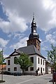
Protestant church
Dreisener Tor

Candlesheimer Tor with the Catholic parish church in the background

King's Cross Chapel
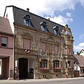
Uhl's house, also a local museum

Ludwigsplatz with Ludwigshalle


The "Uhl'sche Haus" from 1898 is an upper-class residential building in Renaissance style and has housed the local history museum since 1978 . One focus of the collection is the battle of the Hasenbühl . There are also exhibition rooms in the Kerzenheimer Tor.
Parks
Since 2010 , a Geopark or a so-called "Tertiary Park" has been set up in the abandoned Dachsberg quarry, which was part of the local cement works of the Dyckerhoff company . It is located between Göllheim and Marnheim and is freely accessible from the state road near the Elbisheimerhof . Several display boards explain the geology, flora and fauna along a circular route of around one kilometer.
Natural monuments
There are a total of five natural monuments on site .
Regular events
| Surname | time |
|---|---|
| Königskreuzrennen | every spring since 1988; Exceptions: 2010–2012, among other things because of hosting the Rhineland-Palatinate Championships |
| Spring market | the first weekend in May |
| Motorcycle meeting | every year in early May; extends over a whole weekend |
| Göllheim Archway Festival | Yearly; has meanwhile acquired regional importance |
| Autumn market | the third weekend in October |
| Göllheim pre-Christmas | mostly on the first weekend in December |
Sculptures
In 1986 the Göllheim symbolic figures were erected. Theo Rörig's three sculptures represent the night watchman, the parish servant and the local goose herdsman. The 2007 sculpture symposium had the motto “Blickachsen”. Sculptures were positioned in the old town center in such a way that they are in dialogue with one another. Sculptures that were not part of the symposium are also listed here.
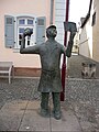
“Police and community servants” by Theo Röhrig

“Night watchman with dog” by Theo Röhrig

"Scion" from Rüdiger Krenkel
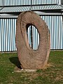
"Aufbruch" by Uta Schade
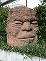
"World face" by Uli Lamp

“Kaleidoscope of memories” by Bruno Weygand

"Juggler" by Uli Lamp

"Red frame" by Motz Tietze

“Göttergewächse” by Stephan Voigtländer

"Donnersberger Netsuke " by Wolfgang Seipenbusch

"Creation of the World" at the Bible Garden of the Catholic Church


Sports
Stop machine
Göllheim has been part of the Stoppomat series since May 2014 . The Stoppomat is a device for amateur and recreational athletes and is intended for various sports activities such as cycling or running.
Königskreuzrennen
The Königskreuzrennen is a cycling race in Göllheim. The Königskreuzrennen was held for the first time on April 10, 1988. The organizer at that time was the cycling department of TUS Göllheim. Since the eleventh edition in 1998, the race has been run by RV Falke Donnersberg e. V. Göllheim organized in 1998.

At the beginning of the 20th century there were three cycling clubs in Göllheim: All Heil Donnersberg 1898 , Germania 1911 and RV Falke 1927 . During this time, regular cycling races were held in the North Palatinate community. At that time competitions were already started at the Königskreuzdenkmal, but street races were also held. At the end of the 1980s, racing was resumed in Göllheim. Today, more than a quarter of a century later, the race at the Königskreuz is a fixture in the racing calendar and continues the more than 100-year history of cycling in Göllheim.
The Königskreuzrennen was usually the prelude to the Palatinate racing season, which is known for its numerous criteria. In 2016, the race date had to be postponed to summer due to road construction work, so the race took place as an evening race for the first time.
The 1.2 kilometer long circuit runs along Königkreuzstrasse, Gutenbergstrasse and Dreisenerstrasse. This is where the name of the race comes from, because the start and finish of the lap is right in front of the Königskreuzdenkmal in Königskreuzstraße. This route has not changed since the second edition in 1989. The triangle course offers the best conditions for high speeds. In the main race of the men’s class, average speeds of up to 45 km / h are achieved, and speeds of over 60 km / h are possible at the top.
The winner is traditionally determined in criterion mode. This means that sprints are run at regular intervals, for example every five laps. The first four racing drivers receive evaluation points. Scoring scheme: 5, 3, 2 and 1 point. In the final round, double the number of points is sprinted. The driver with the most points wins.
In 1989, the record number of 730 racing drivers was recorded on race day.
| Winners list | |||||||||||||||||||||||||||||||||||||||||||||||||||||||||||||||||||||||||||||||||||||||||
|---|---|---|---|---|---|---|---|---|---|---|---|---|---|---|---|---|---|---|---|---|---|---|---|---|---|---|---|---|---|---|---|---|---|---|---|---|---|---|---|---|---|---|---|---|---|---|---|---|---|---|---|---|---|---|---|---|---|---|---|---|---|---|---|---|---|---|---|---|---|---|---|---|---|---|---|---|---|---|---|---|---|---|---|---|---|---|---|---|---|
|
|
|
|||||||||||||||||||||||||||||||||||||||||||||||||||||||||||||||||||||||||||||||||||||||
Economy and Infrastructure
economy

In Roman times, mining was carried out in the western municipality .
The largest employers in the area are Strack Tiefbau GmbH, Dyckerhoff cement factory belonging to Dyckerhoff GmbH , Linde Gas Germany and Sonima GmbH, a global company in the automotive sector. Roman Mayer Logistik Group also has a location in Göllheim. The Feistel fireworks factory used to be located in Göllheim, and it hit the headlines as a result of two major accidents - a fire in the factory building on New Year's Eve and the explosion of an underground bunker. There is also a branch of Volksbank Alzey-Worms on site .
In the south-east of the municipality is the wind farm in enforcement , which was put into operation from 1999 to 2015 , which is partly already in the area of the eponymous community in innsheim. The Göllheimer Wald wind farm has also been located in the west of the district since 2014 .
traffic
The state road 449 runs through Göllheim, which runs from Kerzenheim to Marnheim . In the middle of the village branch off the state road 396 to Ramsen (Pfalz) and the state road 450 to Bockenheim an der Weinstraße .
The community is connected to national traffic via the A 63 ( Mainz - Kaiserslautern ) and the federal road 47 ( Worms - Michelstadt , also called " Nibelungenstraße "), which runs along the western edge of the settlement, as well as the former B 40 .
Göllheim is connected to the local transport network via the bus line 920 of the Rhein-Neckar transport association operated by Omnibusverkehr Rhein-Nahe , which leads to Kirchheimbolanden and Eisenberg.
Public facilities
While it belonged to France, the municipality was the seat of a peace court that was subordinate to the Tribunal of First Instance in Kaiserslautern . As the seat of the association of the same name, Göllheim is home to its administration. There is also a therapeutic children's center in town.
education
Göllheim has a secondary school plus with an attached technical college, as well as a primary school , which are attended by students from all over the region. There is also a community and an evangelical kindergarten. The public community library is connected to the south-west German library network.
tourism

In Göllheim there is the Kriegsberg hut operated by the local group of the Palatinate Forest Association .
The Staudernheim-Soultz-sous-Forêts long-distance hiking trail, marked with a blue bar, runs through the west of the district . In the middle of the settlement area another begins, which is marked with a green-blue bar and which leads to Eppenbrunn .
Personalities
Sons and daughters of the church
- Joseph von Schmauß (1863–1932), Bavarian lieutenant general
- Heinrich Ullmann (1872–1953), architect, landscape painter and photographer
- Ludwig Ullmann (1872–1943), architect
- Emil Straus (1899–1985), educator, diplomat and politician (CVP)
People who worked on site
- Peter Röhrig , 1792/93 member of the Rhine-German National Convention
- Karl von Alwens (1820–1889), lawyer and politician, was a judge in Göllheim until 1860
- Jakob Schwalb (1872–1934), Catholic clergyman, local pastor from 1912
- Theo Fehn (1910–1984), pastor, was temporarily parish administrator in Göllheim
- Peter Roos (* 1950), writer, grew up in Göllheim
- Thomas Maria Mayr (* 1955), psychiatrist, ethnologist and author, has been practicing on site since 1996
literature
- Karl Scherer (Ed.): Göllheim - Contributions to local history. Volume I, Göllheim 2006; Volume II, Göllheim 2009.
- Alexander Thon: Göllheim. In: Jürgen Keddigkeit (Ed.): Palatinate Castle Lexicon. (= Contributions to the history of the Palatinate. Volume 12/2). Institute for Palatinate History and Folklore, Kaiserslautern 2002, ISBN 3-927754-48-X , p. 196 f.
Web links
- Website of the Verbandsgemeinde Göllheim
- Literature about Göllheim in the Rhineland-Palatinate State Bibliography
Individual evidence
- ↑ State Statistical Office of Rhineland-Palatinate - population status 2019, districts, communities, association communities ( help on this ).
- ↑ State Statistical Office Rhineland-Palatinate - regional data
- ↑ State Statistical Office Rhineland-Palatinate (ed.): Official directory of the municipalities and parts of the municipality. Status: January 2019 [ Version 2020 is available. ] . S. 141 f . (PDF; 3 MB).
- ^ Helmut Bernhard: Archaeological finds and findings on the prehistory and early history of the Göllheim area. In: K. Scherer (Ed.): Göllheim - Contributor to local history. Volume I, 2006.
- ↑ Michael Münch: On the history of Göllheim in the Middle Ages. In: K. Scherer (Ed.): Göllheim - Contributor to local history. Volume I, 2006.
- ^ The Regional Returning Officer Rhineland-Palatinate: Local elections 2019 , accessed on August 24, 2019
- ^ Markus Hoffmann: The Göllheim Association - A cultural and historical travel guide. Göllheim 1997.

Albisheim (Pfrimm) | Alsenz | Bayerfeld-Steckweiler | Bennhausen | Biedesheim | Bischheim | Bistiffer | Bolanden | Börrstadt | Breunigweiler | Bubenheim | Dannenfels | Dielkirchen | Dried mussel | Dreisen | Solitude | Eisenberg (Palatinate) | Falkenstein | Finkenbach-Gersweiler | Gauersheim | Gaugrehweiler | Gehrweiler | Gerbach | Göllheim | Gonbach | Gundersweiler | Höringen | Ilbesheim | Immesheim | Imsbach | Imsweiler | Jakobsweiler | Lime kiln | Katzenbach | Candle Home | Kirchheimbolanden | War field | Lautersheim | Pay field | Mannweiler-Cölln | Marnheim | Morschheim | Mörsfeld | Münchweiler an der Alsenz | Münsterappel | Niederhausen an der Appel | Niedermoschel | Oberhausen an der Appel | Upper Muschel | Oberndorf | Oberwiesen | Orbis | Ottersheim | Ramsen | Ransweiler | Rathskirchen | Reichsthal | Rittersheim | Rockenhausen | Ruppertsecken | Rüssingen | Saint Alban | Schiersfeld | Schönborn | Schweisweiler | Souls | Sippersfeld | Sitters | Stahlberg | Standenbühl | Steinbach am Donnersberg | Stetten | Teschenmoschel | Unkenbach | Waldgrehweiler | Wartenberg-Rohrbach | Weitersweiler | Winnweiler | Winterborn | Würzweiler | Zellertal