
Böhl-Iggelheim
| coat of arms | Germany map | |
|---|---|---|

|
Coordinates: 49 ° 22 ' N , 8 ° 18' E |
|
| Basic data | ||
| State : | Rhineland-Palatinate | |
| County : | Rhine-Palatinate District | |
| Height : | 105 m above sea level NHN | |
| Area : | 32.83 km 2 | |
| Residents: | 10,394 (Dec. 31, 2019) | |
| Population density : | 317 inhabitants per km 2 | |
| Postal code : | 67459 | |
| Area code : | 06324 | |
| License plate : | RP | |
| Community key : | 07 3 38 005 | |
| LOCODE : | DE 6B5 | |
| Community structure: | 2 districts | |
| Address of the municipal administration: |
Am Schwarzweiher 7 67459 Böhl-Iggelheim |
|
| Website : | ||
| Mayor : | Peter Christ ( CDU ) | |
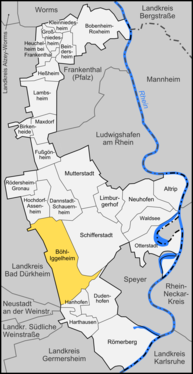
| Location of the municipality of Böhl-Iggelheim in the Rhein-Pfalz-Kreis | ||
  |
||

Böhl-Iggelheim is an association-free municipality in the Rhein-Pfalz district in Rhineland-Palatinate . Böhl-Iggelheim, part of the Rhine-Neckar metropolitan region , is designated as a basic center according to state planning .


geography
Geographical location
Böhl-Iggelheim is located in the Upper Rhine Plain near Ludwigshafen am Rhein and Mannheim (25 km), Speyer (11 km), Neustadt an der Weinstrasse (15 km) and Bad Dürkheim (12 km). The district borders in the southeast on the Ordenswald between Iggelheim and Speyer. The Rehbach flows through Iggelheim.
Neighboring communities
In the north, Böhl-Iggelheim borders on the communities of Hochdorf-Assenheim and Dannstadt-Schauernheim , in the east on Schifferstadt , in the southeast, beyond the Speyer Forest, on Dudenhofen and Hanhofen , in the west on the communities of Haßloch and Meckenheim in the Bad Dürkheim district . The city of Speyer is located southeast of Böhl-Iggelheim, but it does not border on the municipality of Böhl-Iggelheim, but is separated from it by a narrow municipality of Dudenhofen.
Community structure
The community consists of the Böhl district in the north and the Iggelheim district in the south. The Buhilohof, Erlenhof, Ostergewannenhof and Steigerthof residential areas also belong to Böhl, and the Eichschwalbe and Waldschänke residential areas to Iggelheim. An area with weekend houses extends south of Iggelheim.
history
Böhl-Iggelheim was created on June 7, 1969 through the merger in the form of a new formation from the previously independent communities Böhl and Iggelheim .
Böhl was created in the 7th / 8th Century as a Franconian foundation and was mentioned for the first time in 780 in a deed of donation in the Lorsch Codex under the name Buhilo . The name, which means something like "hill", has been documented in its current form since 1602.
Iggelheim was probably founded in the 7th century, the first reliable mention comes from a document of the Weissenburg monastery in the form "Uelteheim" in the year 991. The name changed from Ugelnheim to Ygelnheim to the current form used since the 19th century.
Both villages originally belonged to the Franconian tribal duchy, then to the German kingdom and retained their imperial status until 1330 . Together with Haßloch and probably Iggelheim too, Böhl was then pledged by Emperor Ludwig the Bavarian to Count Palatine Rudolf II and Ruprecht I. Until the beginning of French rule in 1797, Böhl and Iggelheim remained under the rule of the Electorate of the Palatinate, only interrupted by belonging to the Duchy of Pfalz-Zweibrücken from 1410 to 1507. In 1379, the places were mortgaged by the Count Palatine to the Count of Leiningen . During the Thirty Years' War , both villages were plundered several times by mercenary armies (Spaniards, Swedes) and partly burned down.
After the end of French rule, the communities of Böhl and Iggelheim belonged to the Speyer district office in the Rhine district, later Palatinate (Bavaria) . In 1886 the part of the Speyer district office, to which Böhl and Iggelheim also belonged, was incorporated into the newly formed Ludwigshafen district office, from which the Ludwigshafen am Rhein district , now part of the Rhein-Pfalz district , emerged in 1939 .
From 1930 to 1934, the town's water supply was built, the centerpiece of which is the striking Böhl water tower .
In the summer of 2001, neo-Nazis carried out arson attacks on the caravan settlements of around 30 Sinti and Roma in the green area next to the regional school . Through a note in the ARD program Tagesschau, Iggelheim briefly moved into the national spotlight and was considered an example of new right-wing extremist attacks. Since the caravans were completely uninhabitable after the attacks, the residents were placed under protection and moved to asylum seekers' homes in the area. However, around 17 of the 28 Sinti and Roma were deported to their home countries in 2003. The arsonists could never be identified and held accountable.
In April 2002 a human chain took place as a demonstrative act against US foreign policy. Approx. 300 people (including church groups, orchestras and private individuals) tied a symbolic bond along the bypass road between Böhl and Iggelheim.
religion
In 2008, 42.6 percent of the population were Protestant and 30.7 percent Catholic. The rest belonged to another religion or were non-denominational.
- The Protestant parishes
In contrast to the political community of Böhl-Iggelheim, the Protestant parishes in the districts of Böhl and Iggelheim are independent, even if both belong to the Schifferstadt parish, the Speyer church district and the Evangelical Church of the Palatinate (Protestant regional church ). The Protestant churches Bohl (1800 members) and Iggelheim (about 3000 members) are looked after a parish priest of each. The "Evangelical Christ Church Böhl-Iggelheim" (formerly "Landeskirchliche Gemeinschaft Iggelheim") is an independent congregation with around 40 members. She is looked after by a parish pastor. A total of 4800 inhabitants are Protestant.
- The Jewish community
There was a Jewish community in Böhl-Iggelheim until 1940. Its origins go back to the 18th century. In 1744 three Jewish families lived in Iggelheim, in Böhl there was only one family. They buried their dead in the Jewish cemetery in Haßloch . In Böhl a maximum number of Jewish residents was reached around 1848 with 79 people in 15 families. The number fell rapidly through emigration and emigration. By 1910 everyone left the place. In Iggelheim the maximum number was reached in 1866 with 44 Jewish community members. Here emigration and emigration did not start in the same way as in Böhl, so that around 1900 there were still 34 Jewish people here. In 1933, there were 16 Jewish residents in Böhl-Iggelheim, in 1938 14 or 15. Only after the events of the pogrom night did some of these people move away. Seven Iggelheim Jews were deported to Camp de Gurs in October 1940 and were later murdered in extermination camps in the East. The synagogue in Böhl, inaugurated in December 1840, was desecrated during the November pogrom in 1938 and completely devastated inside before it was demolished in 1941. Today a memorial stone commemorates the synagogue.
Population development
The first recorded population of Böhl names 110 households and thus 400–500 inhabitants in 1550, who settled in the area of today's Kirchenstrasse, probably also on Hauptstrasse and Ludwigstrasse. This did not change much by the end of the 17th century; 75 households are given for 1685. By the middle of the 18th century, the square of Kirchenstrasse / Hauptstrasse / Ludwigstrasse / Bismarckstrasse was fully developed; for 1785 the number of 901 inhabitants is given. With the end of the immigration restrictions (1797) the population increased sharply, in 1815 1200 inhabitants were counted, in 1840 1595 inhabitants. Thereafter, the number of inhabitants and the size of the village remained largely unchanged until around 1900; in 1900 there were only a few more inhabitants at 1752 than 60 years earlier. The expansion that followed at the beginning of the 20th century was towards the south to the train station on the Ludwigshafen - Neustadt railway line . At the end of the Second World War, Böhl then had 3,064 inhabitants. Later, new development areas were created in the area between the railway line and the old town center and to the east of it, until 1987 the population had risen to 3836.
Iggelheim developed from a typical regional street village with the church at one end and the town hall at the other end of the only populated street, here Langgasse. In the 16th century there were around 250 inhabitants in Iggelheim, and this number is unlikely to have changed in the following century. An expansion of the place then began with the reconstruction after the Palatinate War of Succession . Another rapid population increase took place at the beginning of the 19th century after the immigration restrictions were lifted. Thereafter, the population remained largely constant until 1900, when Iggelheim had about 2200 inhabitants, before the population increased again. At the end of the First World War the place had 2800 inhabitants, in 1938 there were 3412. After the Second World War the built-up area had doubled again to this day, in 1968 there were 5500 inhabitants, in 1987 it was 6551.
politics

Municipal council
The municipal council in Böhl-Iggelheim consists of 28 voluntary council members who were elected in a personalized proportional representation in the local elections on May 26, 2019 , and the full-time mayor as chairman.
Distribution of seats:
| choice | SPD | CDU | GREEN | FDP | FWG | AfD | BIL | total |
|---|---|---|---|---|---|---|---|---|
| 2019 | 6th | 9 | 5 | - | 4th | 4th | - | 28 seats |
| 2014 | 9 | 11 | 3 | - | 4th | - | 1 | 28 seats |
| 2009 | 9 | 10 | 2 | 1 | 4th | - | 2 | 28 seats |
| 2004 | 10 | 10 | 2 | - | 4th | - | 2 | 28 seats |
- FWG = Free Voting Association Böhl-Iggelheim e. V.
- BIL = Böhl-Iggelheimer List e. V.
mayor
Mayor of Böhl-Iggelheim has been Peter Christ (CDU) since 2007. In the direct election on September 21, 2014, he was confirmed in office for a further eight years with a share of 62.3% of the votes.
coat of arms

Bohl

Iggelheim


|
|
Blazon : "Divided by blue and gold, above a red armored silver eagle, below a red scales." |
Justification of the coat of arms: It was approved by the Neustadt district government in 1973 and contains elements of the historical coats of arms of Böhl and Iggelheim.
|
Community partnerships
A partnership has been maintained with Wahagnies near Lille ( France ) since 1991, and with Schlanders in South Tyrol ( Italy ) since 2004/2005 .
Since 1992 the aid association Children of Shitkowitschi - Life after Chernobyl has maintained a partnership with the region around the city of Shitkowitschi ( Ukraine ).
Culture and sights
Attractions
District of Böhl
- Böhl water tower
- Village square with baroque church, schoolhouse and old half-timbered houses, Schulstrasse
- Catholic Church, Kirchenstrasse
- Oldest house in the district at Kirchenstrasse 17 (built in 1581)
- Listed half-timbered houses, Hauptstrasse, Kirchenstrasse
- Jewish memorial of the destroyed synagogue

Water tower

Schoolhouse and Protestant baroque church

Catholic Church


District Iggelheim
- Old town hall in Iggelheim with local history museum (1569), Langgasse 2
- Old school house (today local museum), Haßlocher Straße 2
- Birthplace of Jakob Heinrich Lützel, Lützelstrasse 25
- Protestant church, Haßlocher Straße (on the cemetery grounds), tower (approx. 1000), ship (1756)
- Listed half-timbered houses, Buschgasse, Langasse
- Memorial stone at the POW camp Rheinwiesenlager opposite Wasgau
- Fallen memorial in front of the elementary school in Langasse
- Jewish grave and memorial site
- Roman Catholic Church
In addition, many half-timbered houses have been preserved in both districts, some from the 16th century.
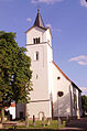
Protestant Church
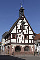
Local museum
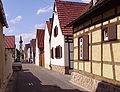
Alley with half-timbered house in Böhl

Jakob Heinrich Lützel's birth house

Inscription in the beam from the Lützelhaus
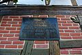
Memorial plaque at the Lützelhaus


See also: List of cultural monuments in Böhl-Iggelheim
Nature & relaxation

- Weekend area and the forests of the communities Böhl and Iggelheim
- Niederwiesenweiher recreational area
- Naturfreundehaus Böhl
- Naturfreundehaus Iggelheim
Economy and Infrastructure
The library software specialist OCLC (formerly BOND ) has an important branch in Böhl-Iggelheim. In addition, the companies Presswerk Böhl and SÜDWEST Lacke + Farben are located.
Public facilities
- town hall
- Youth center JUZ
- Wahagnieshalle
- Evangelical and Catholic community centers
- Catholic community library
schools
- Jakob Heinrich Lützel Primary School Iggelheim
- Johannes Fink Primary School Böhl

- Peter-Gärtner-Realschule plus
- Location of the FHS (district adult education center)
traffic
Böhl-Iggelheim has good transport connections in the direction of the center of the region (Mannheim / Ludwigshafen / Heidelberg), be it via the A 65 , A 61 or the RheinNeckar S-Bahn . The S-Bahn lines S1, S2, as well as the S3 and S4 in the morning and evening, depart every 15 minutes from the train station in the Böhl district during rush hour .
Personalities


Sons and daughters of the church
- Nikolaus Schöneck (~ 1500–1561), last Catholic pastor of Neustadt an der Weinstrasse before the Reformation
- Justus Siebein (1750–1812), Bavarian General, Knight of the French Legion of Honor and Commander of the Bavarian Military Max Joseph Order .
- Jakob Heinrich Lützel (1823–1899), Iggelheim composer, choir director, elementary school teacher and organist
- Walter Hauck (1910–1991), concert and opera singer specializing in the lyric baritone
- Johannes Zehfuß (* 1959), politician (CDU)
People who worked on site
- Hans Freistadt (* July 6, 1945 - October 23, 2019), former flyweight boxing world champion
- Bruno Hain (born September 24, 1954), dialect poet, born in Ludwigshafen, grew up in Böhl-Iggelheim
- Johann Valentin Metz (1745–1829), Catholic priest, first cathedral provost and vicar general of the newly established diocese of Speyer in 1818 ; 1786 to 1803 pastor of Böhl
- Christian Reif (born October 24, 1984), 2010 European Champion in the long jump
- Bernd Sauerhöfer , multiple German and world champion in dog sledding
Web links
- Municipality of Böhl-Iggelheim
- Literature about Böhl-Iggelheim in the Rhineland-Palatinate State Bibliography
Individual evidence
- ↑ State Statistical Office of Rhineland-Palatinate - population status 2019, districts, communities, association communities ( help on this ).
- ↑ State Statistical Office Rhineland-Palatinate - regional data
- ↑ State Statistical Office Rhineland-Palatinate (ed.): Official directory of the municipalities and parts of the municipality. Status: January 2018 [ Version 2020 is available. ] . S. 103 (PDF; 2.2 MB).
- ↑ Official municipality directory (= State Statistical Office of Rhineland-Palatinate [Hrsg.]: Statistical volumes . Volume 407 ). Bad Ems February 2016, p. 160 (PDF; 2.8 MB).
- ↑ Minst, Karl Josef [transl.]: Lorscher Codex (Volume 4), Certificate 2085 - Reg. 11. In: Heidelberger historical stocks - digital. Heidelberg University Library, p. 38 , accessed on January 28, 2016 .
- ↑ ewois.de, as of December 31, 2013
- ^ The Regional Returning Officer Rhineland-Palatinate: Municipal Council Election 2019 Böhl-Iggelheim, non-association municipality. Final result. Retrieved December 7, 2019 .
- ↑ Focus Online: Mayor of Böhl-Iggelheim remains in office. September 21, 2014, accessed December 7, 2019 .
- ^ Karl Heinz Debus: The great book of arms of the Palatinate. Neustadt an der Weinstrasse, 1988. ISBN 3-9801574-2-3 .

Altrip | Beindersheim | Birch heather | Bobenheim-Roxheim | Böhl-Iggelheim | Dannstadt-Schauernheim | Dudenhofen | Fußgönheim | Großniedesheim | Hanhofen | Harthausen | Heßheim | Heuchelheim near Frankenthal | Hochdorf-Assenheim | Kleinniedesheim | Lambsheim | Limburgerhof | Maxdorf | Mother city | Neuhofen | Otterstadt | Rödersheim-Gronau | Römerberg | Schifferstadt | Forest lake