
Maxdorf
| coat of arms | Germany map | |
|---|---|---|

|
Coordinates: 49 ° 29 ' N , 8 ° 17' E |
|
| Basic data | ||
| State : | Rhineland-Palatinate | |
| County : | Rhine-Palatinate District | |
| Association municipality : | Maxdorf | |
| Height : | 95 m above sea level NHN | |
| Area : | 7.35 km 2 | |
| Residents: | 7150 (Dec. 31, 2019) | |
| Population density : | 973 inhabitants per km 2 | |
| Postal code : | 67133 | |
| Area code : | 06237 | |
| License plate : | RP | |
| Community key : | 07 3 38 018 | |
| Association administration address: | Hauptstrasse 79 67133 Maxdorf |
|
| Website : | ||
| Local Mayor : | Werner Baumann ( CDU ) | |
| Location of the local community Maxdorf in the Rhein-Pfalz-Kreis | ||
  |
||

Maxdorf is a municipality in the Rhineland-Palatinate Rhein-Palatinate district with the function of a sub-center . It is the administrative seat of the association of the same name and belongs to it.
Geographical location
Maxdorf is located immediately west of the large cities of Ludwigshafen and Frankenthal in the northern Front Palatinate . Other neighboring communities are Lambsheim in the north , Fußgönheim in the south and Birkenheide in the west . The Floßbach , a right tributary of the Isenach, flows through the village from south to north .
geology
The grave fracture forms in the Oberrheinebene a relay fracture zone with a plurality of blocks. Maxdorf is located on the western moat, which is about 10 km wide here and extends from the Rhine to the Haardt . In the middle of Maxdorf there is a rise in terrain of a few meters in a north-south direction. It is the transition from the lower terrace , also known as the Frankenthaler terrace , to the high terrace to the west . The terrain step was formed in the last ice age when the Rhine flooded the lower terrace. This also the differences in soil structure explained: In the eastern part of Maxdorf where the origin of the settlement area is located, there is an almost loess free, very fertile black soil a loose shifting sand floor, the little productive agriculture -floor, in the West made possible.
history
Until the community came into being
Settlements in the area of today's Maxdorf have already been proven for antiquity, but the history of the Maxdorf community did not begin until the 18th century. In 1736, Elector Karl Philipp III. build a salinarium near Dürkheim , but could not use the wood from the Dürkheim forests that was in Liningian possession, but had to pour wood from forests to the south. At the point where the Floßbach crossed the road to Dürkheim, a wood storage area with a caretaker's house was set up, the wood yard, first mentioned in 1750. In this previously uninhabited, the district of Lambsheim belonging area some Lambsheimer settled families from the 1816th
Lambsheim with the later Maxdorf belonged to the Electoral Palatinate until the end of the 18th century . In October 1794, during the First Coalition War , the Left Bank of the Rhine, and thus also the Palatinate, was occupied by French revolutionary troops. The region was annexed to France in 1798. Until 1814, Lambsheim and the Holzhof belonged to the canton of Frankenthal in the Donnersberg department . Due to the agreements made at the Congress of Vienna , the area became part of Austria in June 1815 . On April 14, 1816, a state treaty was signed between Austria and Bavaria in which an exchange of different national territories was agreed. The Austrian areas on the left bank of the Rhine were ceded to the Kingdom of Bavaria on May 1, 1816 .
From June 22nd to 29th, 1816, King Maximilian I Joseph of Bavaria traveled to the Palatinate, which had just been acquired, but not to that small hamlet, which at that time was still called a wooden yard and is to be regarded as the origin of today's Maxdorf. It was not until May 6, 1819, that the settlement, which had grown to 227 inhabitants, was named after Maximilian I. Joseph Maxdorf . On the occasion of their trip to the Palatinate , on June 7, 1829, his son, King Ludwig I of Bavaria , and his wife Queen Therese visited the place where they were solemnly welcomed. The community, which until then had had a certain degree of independence, lost it in 1865 and was fully integrated into the Lambsheim community. The residents made efforts to achieve independence quite soon, but it was not until October 1, 1952 that Maxdorf was granted independence and its own coat of arms by state law.
BASF settlement
From 1934 onwards, the workers ' housing estate belonging to Fußgönheim was built by BASF workers. The settlers took a year off from work and built the houses together. The plots were originally very large (approx. 1000 m²), as a political goal of the time was the self-sufficiency of the citizens with agricultural products.
In 1938 the Feierabendhaus (today: Carl-Bosch-Haus ) was built as the center of the town and as a venue for parties and performances . It forms a building complex together with the elementary school built in the same year (today: Haidwaldschule ).
Whereas the primary school was previously reserved exclusively for the children of the BASF settlement, later children from Maxdorf were also taken in, as the Maxdorf mayor's strength school was no longer capable of sufficient capacity . In the meantime, the Haidwald School is the sole elementary school for the whole place. In 2004 it was decided to convert it into an all-day school .
Only during the Second World War was the sewer system laid in the village, in part by French prisoners of war. Between 2000 and 2004, the sewage system, which was meanwhile in great need of renovation, was replaced by a new one, the street space was also redistributed (e.g. parking spaces and cycle paths, sidewalks were widened) and the surfaces of the streets were paved.
On June 7, 1969, as part of the Rhineland-Palatinate administrative reform, the BASF settlement with 1602 inhabitants at that time was annexed to Maxdorf, with which it had now grown spatially.
Plane crash
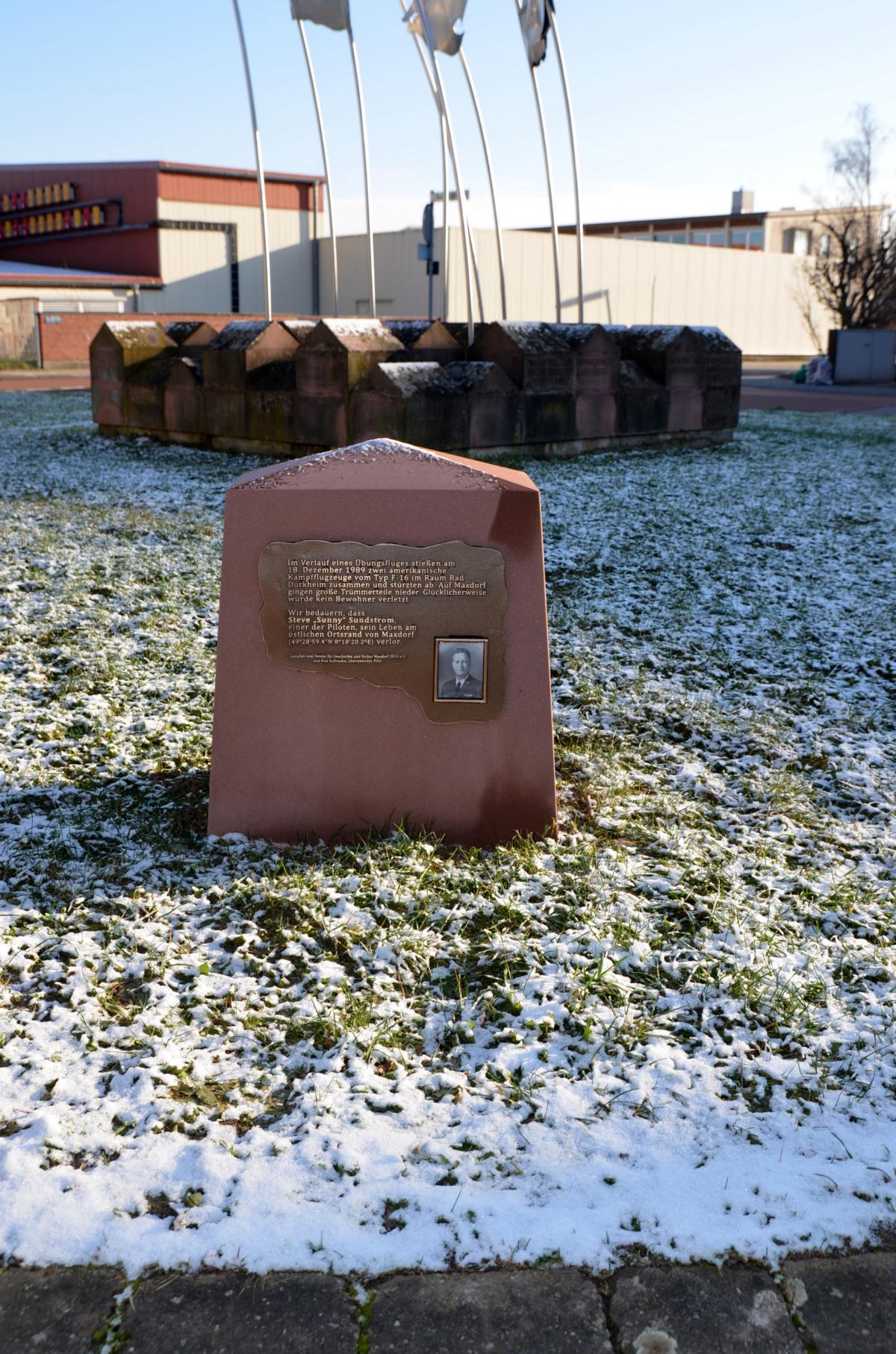
On December 18, 1989, the place was hit by an airplane accident . First, it came in the high air space (4500 m) via Frankenthal the collision of two fighter jets of the type F-16 of the US Air Force , the US-airbase and today's civil airport by then- Hahn were started.
Due to severe damage, both machines were no longer airworthy and crashed in a parabolic curve that continued a few kilometers to the southwest . One of the aircraft wrecks hit the open field, in the Maxdorf district, but only 200 m from the houses in the Ludwigshafen district of Oggersheim and immediately west of the four-lane federal highway 9 . The largest pieces of debris from the second aircraft fell in the middle of the hall of the wholesale market north of the center of Maxdorf. The market hall was almost empty at the time of the disaster and there were no deaths or injuries.
Rod Kallman, the pilot of the plane that crashed in the wholesale market, was able to save himself with the ejector seat and went down on a parachute 11 km northeast, between Frankenthal and Bobenheim-Roxheim . The other pilot, 29-year-old Steve Sundstrom, whose parachute did not deploy, died in his destroyed cockpit .
Because of the crash, a citizens' initiative against military flight exercises was founded on February 7, 1990 . She later joined the Mittelhaardter Association against Aircraft Noise as a local group and drew attention to the accident with vigils, ecumenical services and demonstrations until this association was dissolved . Also in 1990 at the Palatinate dialect competition Dannstadter Höhe, the poem Fluuchiewung (flight exercise), which dealt with the incident, was awarded a prize. The poem was reprinted several times in the following years.
Since 1992 (3rd anniversary) and 2014 (25th anniversary) a memorial and a memorial stone have stood next to each other in Maxdorf, commemorating the accident. The memorial stone, which the surviving pilot from 1989 was present when it was erected on December 28, 2014, is specially dedicated to the pilot who died.
politics

Municipal council
The municipal council in Maxdorf consists of 22 council members, who were elected in a personalized proportional representation in the local elections on May 26, 2019 , and the honorary local mayor as chairman.
The distribution of seats in the municipal council:
| choice | SPD | CDU | GREEN | FDP | total |
|---|---|---|---|---|---|
| 2019 | 6th | 9 | 4th | 3 | 22 seats |
| 2014 | 8th | 12 | - | 2 | 22 seats |
| 2009 | 9 | 9 | - | 4th | 22 seats |
| 2004 | 10 | 8th | 1 | 3 | 22 seats |
mayor
Werner Baumann (CDU), elected local mayor for the first time in 2009 with 61.7% of the votes, was re-elected in 2014 with 61.8% and in 2019 with 53.43%.
- 1952–1962: Hugo Kraft
- 1962–1964: Ludwig Pfarr
- 1964–1987: Albert Funk (SPD)
- 1987–1994: Hans Marnet (SPD)
- 1994–2009: Theo Hauck (SPD)
- 2009– : Werner Baumann (CDU)
coat of arms
|
|
Blazon : "Under a lowered shield head roughened with silver and blue, covered with a golden royal crown, set in silver and red, covered with a blue wavy bar, inside a golden tree trunk."
The coat of arms was awarded to Maxdorf on July 12, 1957. |
| Justification for the coat of arms: The diamonds stand for the Kingdom of Bavaria, under whose rule the founding of Maxdorf falls, the royal crown symbolizes the approval of the place name by King Maximilian. The silver-red quartered shield part of the noble Leyser von Lambsheim family comes from the Lambsheim local coat of arms , the corrugated beam with tree trunk reminds of the origin of the place from the wooden yard that was laid out for the rafting. |
Culture and sights
- The Catholic parish church of St. Maximilian was built in 1904/05 in the neo-Romanesque style.
- The Protestant parish church was built in the neo-Gothic style between 1914 and 1921.
- The Protestant Johanneskirche was built in the BASF settlement in 1952/53 and is looked after by the parish office in Birkenheide.
- The Maxdorf pyramid, built in 1993, is a three-sided glass pyramid in which cultural events are held.

Catholic Church

Protestant Church

pyramid

Roundabout


Economy and Infrastructure
traffic
Immediately to the east of Maxdorf, the A 61 ( Koblenz - Hockenheim ) passes as a north-south connection , 4 km further east, the B 9 (Ludwigshafen - Speyer ) runs parallel to it . The A 650 ( Bad Dürkheim –Ludwigshafen), which runs south of the town, serves as a west-east connection .
The narrow-gauge Rhein-Haardtbahn , used by RNV line 4 from Mannheim to Bad Dürkheim, connects Maxdorf to the rail network with two stops. The place belongs to the tariff area of the Verkehrsverbund Rhein-Neckar . There is also the 483 bus that connects Maxdorf with Birkenheide . There is also a very seldom used bus connection to Bad Dürkheim.
A citizen bus also connects the places of the association to places where there is no or very seldom a bus.
education

In Maxdorf there is a primary school, a secondary school plus and, since 2008, a grammar school:
- Lise-Meitner-Gymnasium G8GTS, Maxdorf
- Justus-von-Liebig-Realschule plus, Maxdorf and Lambsheim
- Haidwaldschule primary school, BASF housing estate
The community also operates a public community library and offers adult education courses.
Personalities
- Theobald Hauck (1902–1980), sculptor and honorary citizen
- Werner Schröter (* 1944), wrestler and politician (SPD), lives in Maxdorf.
- Ralf Stegner (* 1959), politician (SPD), grew up in Maxdorf.
literature
- Wilhelm Becker: Maxdorf. Chronicle of a young community . Emil Sommer Verlag, Grünstadt 1987.
- Otto Reis: Pictures of a Village . Kunstverein Maxdorf (ed.), Maxdorf 1986.
- Walter Sattel: The local history of Maxdorf . Graphics & advertising Faulhaber, Neuhofen 2006.
- Walter Sattel: Families and Individuals in Maxdorf, a local family register from 1748–1900 . Graphics & advertising Faulhaber, Neuhofen.
- Wolfgang Kunz, Henning Cramer, Wolfgang Fluck: Maxdorf: History and nature. Knecht-Verlag, Landau 2014.
- Wolfgang Kunz: The King's Journey - Max I. Joseph on Palatinate Journey 1816. Knecht-Verlag, Landau 2016.
Web links
- Verbandsgemeinde Maxdorf: History of Maxdorf
- Literature about Maxdorf in the Rhineland-Palatinate State Bibliography
Individual evidence
- ↑ State Statistical Office of Rhineland-Palatinate - population status 2019, districts, communities, association communities ( help on this ).
- ↑ Wolfgang Kunz: The King's Journey - Max I. Joseph on Palatinate Journey 1816. Knecht-Verlag, Landau 2016, p. 9.
- ↑ Georg von Jäger : Des Rheinkreis Jubelwoche , 1829, p. 32; (Digital scan of the book).
- ^ Wilhelm Volkert (ed.): Handbook of Bavarian offices, communities and courts 1799–1980 . CH Beck, Munich 1983, ISBN 3-406-09669-7 , p. 463 .
- ↑ Official municipality directory (= State Statistical Office of Rhineland-Palatinate [Hrsg.]: Statistical volumes . Volume 407 ). Bad Ems February 2016, p. 184 (PDF; 2.8 MB; footnote 41).
- ↑ a b US warplanes crash on Maxdorf. Association for History and Culture Maxdorf 2010, December 14, 2012, accessed on September 5, 2018 .
- ↑ a b c memorial stone. Association for History and Culture Maxdorf 2010, December 28, 2014, accessed on September 5, 2018 .
- ↑ Albert H. Keil: Fluuchiewung. Verlag PfalzMundArt, accessed on January 25, 2017 .
- ↑ reprint u. a. in Michael Geiger, Günter Preuss , Karl-Heinz Rothenberger (eds.): The Rhine and the Palatinate Rhine plain . Verlag Pfälzische Landeskunde, Landau in der Pfalz 1991, ISBN 3-9801147-3-2 , p. 423-424 .
- ↑ Memorial stone for Steve Sundstrom. www.maxdorfer-geschichte.de, December 2014, accessed on September 5, 2018 .
- ↑ The Regional Returning Officer: Local elections 2019, city and municipal council elections
- ^ The Regional Returning Officer Rhineland-Palatinate: Municipal elections 2014, city and municipal council elections.
- ^ The Regional Returning Officer Rhineland-Palatinate: Election of the honorary local and city mayors , accessed on December 2, 2015.
- ^ The Regional Returning Officer RLP: direct elections 2019. see Maxdorf, Verbandsgemeinde, third line of results. Retrieved October 9, 2019 .
- ↑ Description of the coat of arms. Verbandsgemeinde Maxdorf, accessed on June 25, 2018 .

Altrip | Beindersheim | Birch heather | Bobenheim-Roxheim | Böhl-Iggelheim | Dannstadt-Schauernheim | Dudenhofen | Fußgönheim | Großniedesheim | Hanhofen | Harthausen | Heßheim | Heuchelheim near Frankenthal | Hochdorf-Assenheim | Kleinniedesheim | Lambsheim | Limburgerhof | Maxdorf | Mother city | Neuhofen | Otterstadt | Rödersheim-Gronau | Römerberg | Schifferstadt | Forest lake