
Isenach


The Isenach , also called Mörschbach on the lower reaches , is a 36 km long stream and a left or western tributary of the Rhine in Rhineland-Palatinate . It flows in the northeastern Palatinate and is in the area of the mouth of the border waters to the southeastern Rheinhessen .
course

The Isenach rises in the northern Palatinate Forest 2 km southwest of Carlsberg-Hertlingshausen , where the Eckbach originates beyond the local watershed . The Isenach spring in the Diemersteiner forest on the southeast flank of a saddle at 325 m above sea level. NHN between the elevations Krummes Eck ( 449 m ) and Hohe Bühl ( 444 m ) is marked by the knight stone 277 with the inscription Isenach-Ursprung . The course of the water is initially about 5 km to the southeast, shortly after flowing through the Isenachweiher it then follows the valley in an easterly direction, in which the federal road 37 ( Kaiserslautern - Bad Dürkheim ) also runs.
At Bad Dürkheim the Isenach breaks through the Haardt , the eastern edge of the Palatinate Forest, and enters the hill country with vines on both sides of the German Wine Route . The Upper Rhine Valley , they then crossed to the northeast and passes Erpolzheim who deserted Eyersheim ( Eyersheimer mill and Eyersheimer Hof , today the district Weisenheim am Sand belonging) and Lambsheim . Below Erpolzheim the Isenach takes on the Schlittgraben from the left , below Lambsheim from the right the Floßbach . Then it crosses under the Autobahn 61 ( Koblenz - Speyer ). As a result, it forms the border between the Frankenthal districts of Eppstein and Flomersheim .
In the southeastern urban area of Frankenthal, before the piped Fuchsbach joins a small part of its water from the left , the Isenach turns north and forms the city boundary between Frankenthal and Ludwigshafen for almost a kilometer . On its course through the Frankenthal suburb of Mörsch , the Isenach is also called Mörschbach . It runs in the east of Bobenheim-Roxheim on a dam around the Roxheimer Altrhein , crosses under the federal highway 9 and finally flows into the Upper Rhine at a height of 87 m 4 km south of Worms from the left . On the last 500 m of its course it forms the border between the Palatinate in the south and Rheinhessen in the north.
history
Surname
The first part of the name Isenach combines linguistics with the iron ore that was previously mined in the region, the second with the still mainly in Southern frequent and as feminine used river or stream name Ache , from the Old High German as aha is handed down . So Isenach means Eisenbach .
timeline
In ancient times the Isenach was the border between nemeters and vangions .
The Duke pond at the western entrance of Bad Durkheim was in the Middle Ages as Woog artificially created and for the first time in 1408 as Fischwoog mentioned; In 1571 there is talk of an associated mill. This was replaced by a new building in 1588, which was initially called the Pfalzneumühle and then the Herzogmühle . The Herzogweiher also served to regulate the flow of water in the Isenach.
Further above, about 5 km after its source, the Isenach was dammed into another woog, the Isenachweiher, in 1736/37, in order to ensure that the river flows evenly. This was necessary because the pumps of the Bad Dürkheim graduation house, also built in 1736, were operated with hydropower until 1850, which was obtained from the Isenach. In addition, the reservoir ensured the supply of a mill wheel below the dam . The dam wall was repaired and restored in the mid-1980s.
In the middle of the 18th century, the Lambsheimer mill was built on the middle Isenach . In order to achieve a steeper gradient for their water supply, the creek bed above the mill was raised by 2 m over a distance of about 1400 m and the Isenach water was partly diverted into a new mill canal. This dam location, combined with later straightening of the upper course of the water, caused flooding in Lambsheim again and again after heavy rain . In 2008, the elevation of the creek bed, which was more than 250 years ago, was reversed and the water was renatured . Since the excavation was contaminated by the input and deposition of naturally occurring arsenic from the Palatinate Forest, it had to be disposed of as hazardous waste. The mill canal was preserved as an industrial monument . To prevent it from drying out, it is continuously supplied with water via a pumping station. The entire renaturation measure cost 780,000 euros, of which the state of Rhineland-Palatinate took over 500,000 euros.

In the 1780s, the Isenach on the southern edge of Frankenthal was diverted to the north from its originally eastward flow direction in order to use the water together with that of the Fuchsbach to fill the then newly built canal port . For more than a century and a half, the Frankenthal Canal functioned as the new Isenach confluence with the Rhine. With the closure of the canal, which became necessary in 1944 after severe bomb damage during the Second World War , the Isenach was led even further north at an old lock . Overall, today's Isenach estuary is about 8 km down the Rhine compared to the oldest; thus the length of the water has increased by about 5 km.
The first public bathing establishment in the city of Frankenthal consisted of a pond-like extension of the Isenach. It was outside in the south at the Post Bridge , which led across the river, and was operated until the lido in the east of the city was opened in 1933/34 . In the area of the Post Bridge, Mahlastrasse now forms the southern entrance to the city center.
In Bad Dürkheim, a 1.5 km long section of the Isenach, which was piped in the 20th century, was exposed again, so that it flows above ground through the spa gardens and past the salt works as it used to. The project, which opened in 2013, was carried out for reasons of flood protection, but also for ecological and design reasons.
Attractions

Isenachweiher
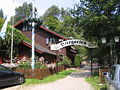
Forsthaus zur Isenach

Leininger fortress Hardenburg

Limburg monastery ruins

Celtic ring wall pagan wall

Roman quarry Kriemhildenstuhl

Isenach below the Hardenburg

Palatinate Museum for Natural History
Dürkheim giant barrel

Isenach and Michaelskapelle

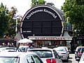
Graduation tower Bad Dürkheim

Isenach in Erpolzheim

Lambsheimer Mill

Lambsheimer Mill

Former lock of the Frankenthal Canal


.jpg)


.jpg)


Isenachweiher
At the spot where once stood the house of the guard, who had to oversee the reservoir, now stands a spacious forest inn that as blockhouse executed Forsthaus Isenach . Rowing boats can also be rented there.
Iron hammer
The Gasthaus Alte Schmelz 3 km below the Isenachweiher still contains parts of an iron hammer that was driven with the water of the Isenach like a mill.
Castle and monastery
Shortly before the Isenach breaks through the eastern edge of the Palatinate Forest, the ruins of two medieval buildings, the Hardenburg and the Limburg Monastery, lie on the right above the Dürkheim Valley . The castle goes back to the noble family of Leininger , the monastery was founded by Emperor Konrad II .
Celtic and Roman finds
To the left above the Dürkheim Valley, opposite the castle and monastery, there is the Heidenmauer , a Celtic ring wall from around 500 BC. BC, the former Roman quarry Kriemhildenstuhl and the monolith of the Teufelsstein , which was the subject of religious rites in the Celtic era .
Natural History Museum
The Palatinate Museum for Natural History to the west of the town center of Bad Dürkheim was established in 1981 in the historic Herzogmühle at the Herzogweiher . One of his most famous exhibits is the Krähenberg meteorite from 1869.
Graduation tower
The Bad Dürkheim graduation house, which is used for spa purposes , was rebuilt after arson attacks in 1992 and 2007 and reopened in 1997 and 2010, respectively.
Frankenthal Canal
At the interface between the Isenach and the abandoned Frankenthal Canal is the old lock, which was expanded in the second half of the 20th century to become a retention basin in the event of flooding.
economy
The Isenach already supplied water for the paper industry in the Dürkheim Valley. Because the process water was returned uncleared for a long time , the stream used to be an intense brown discoloration. That is why the water was popularly called "Colabach" during the 20th century. The stream still carries pollutants today, albeit less than before. That is why the Structure and Approval Directorate South in Neustadt an der Weinstrasse has opened a pilot project in Isenach ; with it, the course should be renatured and the water quality should also be raised.
On the municipal side, the Isenach-Eckbach water body is responsible for the care of the stream , which is subordinate to the Bad Dürkheim district .
Web links
- SGD Süd : Isenach pilot project (PDF; 68 kB)
- pfalzbild.de: Isenachweiher
Individual evidence
- ↑ a b Topographic map 1: 25,000.
- ↑ a b c Rhineland Water Management Administration
- ^ German Hydrological Yearbook Rhine Region, Part I 2009 State Institute for Environment, Measurements and Nature Conservation Baden-Württemberg, p. 132, accessed on January 22, 2016 (PDF, German, 1.85 MB).
- ^ Ludwig Schmidt : The West Germans. (= History of the German tribes up to the end of the migration. Volume 2), Munich 1940, reprint 1970, p. 134.
- ^ Chronicle of the duke pond. Angelsport-Club Isenach, accessed on March 11, 2016 .
- ↑ Source for the entire paragraph: Isenach spreads out in the new bed . In: Die Rheinpfalz , local edition Frankenthaler Zeitung . Ludwigshafen December 9, 2008.
- ↑ Disclosure and renaturation of the Isenach . City administration Bad Dürkheim. Retrieved March 11, 2016.
- ↑ SGD Süd: Isenach pilot project ( Memento of the original from March 27, 2012 in the Internet Archive ) Info: The archive link was automatically inserted and not yet checked. Please check the original and archive link according to the instructions and then remove this notice. (PDF; 69 kB)