Canal Harbor (Frankenthal)
The Upper Palatinate city of Frankenthal was formerly connected to the Rhine , which flowed 4 km to the east, via the canal port and the associated Frankenthal Canal .
geography
The old port basin is in the east of the city, just outside the former city wall . It is bordered in the north by the street Am Kanal , in the south by Edigheimer Straße , which Frankenthal then leaves as the B 9 towards the east and is then called Kanaldamm in the neighboring town of Ludwigshafen . The B 9 accompanies the route of the former canal, three quarters of which today leads over Ludwigshafen area, towards the Rhine.
The only remnants of the canal are a retention basin just before the end of the Frankenthal district at the site of a former lock and an approximately 300 m long section ( ⊙ ) on the southern edge of the Ludwigshafen-Pfingstweide industrial area .
investment
The canal followed the old geological drainage line of the Fuchsbach , which at that time ran parallel to the north of the Isenach and how it flowed directly into the Rhine from the left . The Fuchsbach, which still flows openly through the city, was introduced into the harbor basin just east of the Frankenthal residential development, the Isenach about 900 m east into the canal via a specially dug ditch that led it north and with the current bed of the stream between Kleiner Wald , Monte Scherbelino and the city limits of Frankenthal / Ludwigshafen is identical.
The Fuchsbach was divided up above Frankenthal in the second half of the 20th century. Its larger amount of water is now diverted to the left into the Schrakelbach , only a small amount still flows into the Isenach in Lambsheim .
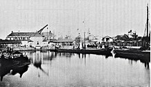
The canal was 4467 m long, 8 to 19 m wide and 2 m deep. It ran from west to east and flowed into the Rhine at what is now BASF's northern port . The harbor basin had a length of 95 m (from west to east) and a width of 48 m. The front side of the basin of massive sandstone quadern was the western quay wall , which is still preserved today. Around the middle, as old pictures show, was a square crane house with a wooden slewing crane , and behind it, parallel to the city wall, was an elongated warehouse, which also housed the customs authorities .
history
First work
In the course of the Middle Ages , the Rhine , which at that time had not yet been straightened, shifted from the periphery of Frankenthal by several kilometers to the east. This made trade difficult, which at that time was carried out to a considerable extent via the waterways. That is why the construction of a canal began in 1580 under the Count Palatine Johann Casimir , who had granted Frankenthal city rights three years earlier . The Count Palatine provided construction timber with which the canal edges were to be secured against being washed away. The work progressed slowly and dragged on even under Johann Casimir's successors. They finally came to a complete standstill during the Thirty Years War (1618–1648). The reason for this was mainly the (unsuccessful) sieges of the city - in 1621 by the Spaniards under General Córdoba and in 1622 by the Imperialists under General Tilly .
completion
It was not until a century and a half later that the project was resumed at the suggestion of Privy Councilor Joseph Fontanesi . Elector Carl Theodor had plans made by his building director Jacob Dyckerhoff and assigned 215 soldiers from his Mannheim garrison for the earthworks . The canal was built between 1772 and 1781, and the harbor basin between 1781 and 1787, which was located southeast of the old town immediately in front of the city wall, which was rebuilt from 1718. The canal ships were pulled by people or horses moving on towpaths . In addition to the connection to the Rhine, the new canal caused the damp lowlands in its vicinity to dry out, so that an additional 5000 acres of arable land could be gained. The elector had the following inscription inserted into the western quay wall, below a crane that has since been demolished, which has been preserved to this day:
"Palatinate or foreigner, if you read this, know Karl Theodor a father and Elector of the Palatinate and Baierlands completed this work in 1781, through Se. Franz Albr, loyal to the Elector's Highness . Freyh. v. Oberndorff , Minister of State and Conference, Joseph Fontanesi and Karl von Maubuißon, secret councilors, Jakob and Christoph Dyckerhoff Vatter and son, court chamber councilors. "
War and flood
When French revolutionary troops conquered the area of the Electoral Palatinate on the left bank of the Rhine from 1793 , the bridges, dams and walls of the canal were so severely damaged in the fighting that it could no longer be used only six years after it was opened. In addition, after breaking due to the Congress of Vienna (1815) in the following year, the Kingdom of Bavaria managing now Rhine district called Palatinate took over, during floods in 1816 and 1817 which also damaged Rhine dikes. As a result, large areas of the lowland around the Frankenthal Canal were flooded. This resulted in further damage to the sewer systems, especially underwashing. Only in 1821 did Bavaria approve restoration funds, and when an additional lock 76 m long had been built, the canal could be used again from 1823. But as early as October 1824, new floods again restricted the use of the canal. Nevertheless, the renovation efforts continued until 1839.
Loss of meaning and shutdown
With the construction of the railways, the importance of the canal continued to decline. However, in 1875 the 26-tonne imperial bell of the Cologne Cathedral, cast by Andreas Hamm in Frankenthal, was transported to the Rhine on one of the canal ships.
The canal was not finally closed until the Second World War in 1944, after it was badly damaged by air raids. In 1954/55 the harbor basin, which was considered to be useless, was filled with 45,000 tons of rubble, which had arisen during the bombing of Frankenthal in 1943. In 1966 the canal was filled in, except for the small section in Ludwigshafen-Pfingstweide. The backfilling of the canal also made it necessary to divert the Isenach northwards to Mörsch and Bobenheim-Roxheim .
Modern times
In 1971 the city of Frankenthal took over the western part of the canal area from the state of Rhineland-Palatinate, which is located on its district, with the following monument protection requirement:
"The western harbor basin is to be maintained over a length of at least 60 meters and integrated into the existing green area in such a way that the existing quay walls remain fully visible over the remaining total length of around 170 meters at the greatest possible height."
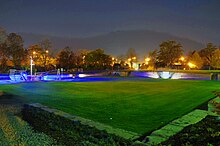
The east park pool and the sports hall at the canal were later built on the eastern part of the site, while the western part was used as a green area - while preserving some old staircases .
Today, the historic buildings - in addition to the restored foundation board from 1781 and additional information boards on site - are reminiscent of the street Am Kanal and the Kanalstrasse . In addition, the Frankenthal artist Martin Adam Foeller created a bronze sculpture “Der Treidler” in 1976 , which he dedicated to the people who once pulled the canal ships; Cast by Max Carius in 1977 or 1978, the sculpture came back to Frankenthal in 2014 and was placed at the Canal Harbor. The art association “Die Treidler” has also named itself after the old profession.
On August 9, 2007, as part of the 2001 “Citizens Project Canal Harbor”, the redesign of the harbor basin - together with the adjacent remnant of the city wall - into a recreational facility.
In November 2009 the project was basically finished, 230,000 euros were invested in the redesign. The community accident insurance, however, asked for a railing to be erected for 15,000 euros and the stairs to be renovated for 20,000 euros. Vandalism caused damage of 9,000 euros to the new lighting before it opened.
literature
- Volker Christmann: Frankenthal - a lost cityscape . 1st edition. Wartberg Verlag, Gudensberg-Gleichen 1995.
- Peter Ruf: The Frankenthaler Canal (= publications of the Ludwigshafen am Rhein city archive . Volume 14 ). Ludwigshafen 1991, ISBN 3-924667-17-9 .
Web links
- Citizens project Kanalhafen on the website of the city of Frankenthal
Individual evidence
- ↑ Anna Maus: The history of the city of Frankenthal and its suburbs . 1970, p. 76 .
- ^ The Rheinpfalz , local edition Frankenthaler Zeitung . Ludwigshafen June 20, 2007.
- ↑ hüf (Claudia Hüfner): Treidler back on the canal. September 20, 2014, accessed April 23, 2018 .
- ↑ Citizens' project: Design of the green area in the former harbor basin of the Frankenthal Canal. City of Frankenthal, accessed December 20, 2011 .
- ^ The Rheinpfalz , local edition Frankenthaler Zeitung . Ludwigshafen November 26, 2009.
Coordinates: 49 ° 32 ′ 4 " N , 8 ° 21 ′ 41" E


