
Lambsheim
| coat of arms | Germany map | |
|---|---|---|

|
Coordinates: 49 ° 31 ' N , 8 ° 17' E |
|
| Basic data | ||
| State : | Rhineland-Palatinate | |
| County : | Rhine-Palatinate District | |
| Association municipality : | Lambsheim-Hessheim | |
| Height : | 98 m above sea level NHN | |
| Area : | 12.75 km 2 | |
| Residents: | 6982 (Dec. 31, 2019) | |
| Population density : | 548 inhabitants per km 2 | |
| Postal code : | 67245 | |
| Area code : | 06233 | |
| License plate : | RP | |
| Community key : | 07 3 38 016 | |
| LOCODE : | DE ZAF | |
| Association administration address: | Mühltorstrasse 25 | |
| Website : | ||
| Local Mayor : | Herbert Knoll ( CDU ) | |
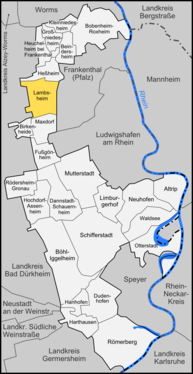
| Location of the local community Lambsheim in the Rhein-Pfalz-Kreis | ||
  |
||

Lambsheim is a municipality in the Rhein-Pfalz-Kreis in Rhineland-Palatinate . It belongs to the Verbandsgemeinde Lambsheim-Heßheim , whose administrative seat it is also.
geography


Lambsheim is located about ten kilometers northwest of Ludwigshafen am Rhein in the Palatinate . Frankenthal is the northeastern neighboring town of the municipality. Other surrounding communities are Maxdorf , Weisenheim am Sand , Gerolsheim , Heßheim and Flomersheim .
To the east of the town center is the Lambsheimer Weiher .
history
Lambsheim, a Franconian town founded in the 6th or 7th century, was first mentioned in a document in 768 in the Lorsch Codex in the form of Lammundisheim . The name developed via Lammesheim to the current spelling, which was used as early as 1387.
Lambsheim must have been owned by the Weißenburg monastery early on and was then given as a fief to the Counts of Leiningen . The first known Leininger was Siegfried Graf von Leiningen (1127). Since the 13th century, the administration has been proven by local knights who had their residence in the former castle (today Junkergasse 1) by 1400 at the latest . In 1323 Lambsheim received town charter and became a mayor's office with limited autonomy in administration. In 1389 Lambsheim came into the possession of the Count Palatinate , who over time acquired more and more shares in the place. In 1410 the city fell to the Dukes of Zweibrücken , who lost them to Elector Friedrich I in a feud in 1471 . At that time, the place was besieged and shot ready for storm by the Palatinate gunner Martin Merz . Until the French rule in 1798, Lambsheim remained in the Electoral Palatinate.
On November 14, 1795, Lambsheim was the site of a military conflict between the German Imperial Army and French revolutionary troops, with around 250 dead. See also: Battle near Lambsheim
From 1816 Lambsheim belonged to the Frankenthal district office in the Bavarian Rhine District , received the right to self-government in 1817 and renounced city rights in 1821. Even after the Second World War, it initially belonged to the Frankenthal (Pfalz) district until it was dissolved in 1969 and Lambsheim was added to the Ludwigshafen district.
In 1865 the previously independent community of Maxdorf was incorporated. The residents made efforts to achieve independence quite soon, but it was not until October 1, 1952 that Maxdorf was granted independence and its own coat of arms by state law.
In 1936, on a court the community Lambsheim awarded district part of the defunct medieval village Eyersheim that since 1952 independent municipality Birkenheide founded.
On the morning of November 10, 1938 , the synagogue was broken into, demolished and desecrated by the National Socialists . The building was demolished by 1957. 26 Jews from Lambsheim, or those born there, perished in camps.
Religions
On October 31, 2014, 38.902 percent of the population were Protestant and 25.959 percent Catholic. The rest of the inhabitants are non-denominational or belong to another religion.
Population development
Shortly after the town charter was granted (1323), Lambsheim was fortified, the fortifications enclosed the area of today's town center (north of the railway line to Turmstrasse with the main and rear streets as the main axes). This area should have been completely built on from around 1600, a condition that remained largely unchanged for 200 years.
After 1800, due to the dissolution of feudal ties, immigration was free, so that the population grew rapidly. In the second half of the 19th century, growth was interrupted when the newly founded and rapidly expanding Maxdorf , at that time still Lambsheimer district, accepted the majority of the newcomers. From 1890, the population increased continuously, also due to the up-and-coming industrial city of Ludwigshafen; until 1933 Lambsheim had 3773 inhabitants.
From 1950 to 1981, the number of residents doubled from 3931 to 5600 and is now around 6900 (as of 2016).


politics
Municipal council
The council in Lambsheim consists of 22 council members, who in the local elections on May 26, 2019 in a majority vote were elected, and the honorary mayor as chairman.
The distribution of seats in the municipal council:
| choice | SPD | CDU | GREEN | FDP | FWG | total |
|---|---|---|---|---|---|---|
| 2019 | 6th | 7th | 4th | 2 | 3 | 22 seats |
| 2014 | 8th | 9 | 3 | 2 | - | 22 seats |
| 2009 | 8th | 6th | 2 | 3 | 3 | 22 seats |
| 2004 | 6th | 8th | 2 | 2 | 4th | 22 seats |
- FWG = Free Voter Group Lambsheim e. V.
mayor
The local mayor of Lambsheim is Herbert Knoll (CDU). In the local elections on May 26, 2019, he was confirmed in his office with 57.90% of the vote.
coat of arms
|
|
Blazon : "In black, a red armored and tongued golden lion, leaning on a shield embroidered with silver and red." |
| Foundation for the coat of arms: It was approved by the Bavarian king in 1841. The Palatinate Lion comes from an old Lambsheim seal. The fourth shield was the coat of arms of the Leyser von Lambsheim , who exercised an after-fief of the Leininger over the place. |
Community partnerships
Lambsheim has had a partnership with Saint-Georges-sur-Baulche in France since 1981 and with the city of Wörlitz in Saxony-Anhalt since 1990 .
Culture and sights
Architectural monuments
- Catholic Church St. Stephanus (Hauptstraße 4)
- Built from 1785 to 1789, small-scale, simple plastered building from the transition from late baroque to classicism . The short bell tower was built from 1909 to 1912 as a ridge rider. The baroque high altar (around 1700), which was brought here from the Simultankirche in Oberndorf in 1961, is worth mentioning .
- Protestant Parish Church (Hauptstrasse 6)
- Neo-Romanesque hall church, a sandstone block built from 1844 to 1847. The tower is located in front of the middle of the south wall, its lower three floors still belong to the previous building from the 13th century, the tower structure with the high pointed spire was built from 1860 to 1861. Inside there are epitaphs of local noble families who were moved here from the previous building; the most important, Jakob von Helmstatt and his wife Maria von Affenstein († 1556), came to the Palatinate History Museum in Speyer in the early 20th century . As the tallest building in the town center, the Protestant parish church shapes the townscape. With a height of 69 meters, the tower is the sixth highest church tower of the Speyer Memorial Church (100 m), the Speyer Joseph Church (91 m), the Speyer Cathedral (two times 71.2 m) and the Castle Church of Bad Dürkheim (70 m) after the towers of the Speyer Memorial Church Front Palatinate.

- Remains of the city fortifications
- The city fortifications, originally built shortly after 1323, were probably completely destroyed in 1471. The fortification built afterwards was damaged several times over the course of time, but was not almost completely removed until 1852 by a municipal decision and against the orders of King Maximilian II . The Neutorturm , the tower of the former gatehouse of the northern city gate, has been preserved at the northern end of the main street . In 1907, a third floor and the roof were added to the original two lower floors. Also from the city fortifications comes a 50-meter-long remnant of the wall south of the two churches, running east-west .
Former Meckenheimer Schloss (Junkergasse 1)
- The building erected around 1500 was destroyed by Philipp von Hessen , then rebuilt. The extensive cellars of this building are still preserved. A kindergarten is located in the rebuilt building.
Former hunting lodge
- The building, built in 1706 and expanded in 1890, is privately owned and, as a baroque aristocratic residence outside the fortifications, of historical importance. The plastered building was designed as a moated castle and is surrounded by a garden. The administration building of the hunting lodge (Mühltorstraße 25), also built in 1706, a little further away, has served as the town hall since its renovation (1991).
See also: List of cultural monuments in Lambsheim
music
The GMV “Volkschor” 1846 has shaped the musical image of the community for 160 years. The GMV orchestra, a wind ensemble made up of almost 40 musicians from Lambsheim and the region, is the backbone of the association; the association also has a mixed choir, a project choir, the youth ensemble and the six-member jazz combo Bluescheme.
societies
In Lambsheim there is the gymnastics club 1864/04, the sport fishing club (SAV Lambsheim), the swimming club Lambsheim (SCL), the sports club Eintracht Lambsheim, the tennis club Lambsheim, the chess club 1997 Lambsheim and a tribe (local group) of the Association of Christian Scouts and Scouts , LandFrauen Lambsheim and the “Schlossnarren” carnival club. CRFN-Camping and Rally Friends Nachtweide as well as an independent local association of the German Red Cross.
Children's and youth circus school "Circus Lamundis"
Since May 2004 there is a child and youth circus school "Circus Lamundis" belonging to the community. The youth exercise leaders are trained by the Federal Circus Education Working Group and impart knowledge about the individual circus disciplines. In the circus management, social pedagogues pay attention to the implementation of the ability to social skills such as teamwork, realistic self-assessment, critical ability etc. and take care of organizational matters.
Economy and Infrastructure

Lambsheim has a stop on the Freinsheim – Frankenthal railway line . From here there is an hourly connection to Frankenthal. In addition, the municipality has connections to the nearest larger cities Frankenthal and Grünstadt as well as the rest of the Rhine-Palatinate district via the VRN bus routes 452 and 482 .
Lambsheim is only a few kilometers away from the Ludwigshafen and Frankenthal motorway junctions , which means that there is a quick connection to the Federal Motorway 6 and the Federal Motorway 61 .
Personalities
Sons and daughters of the church
- Johannes von Lambsheim (~ 1450– ~ 1500), Augustinian canon , scholar and spiritual writer in the Kirschgarten Monastery in Worms , prior in the Höningen Monastery
- Ferdinand Geib (1804–1834), co-founder of the “German Press and Fatherland Association”, participant in the Hambach Festival
- Karl Gustav Geib (1808–1864), secretary and teacher to King Otto of Greece, professor of law
- Carl Christian Baum (1840–1907), engineer
- Käthe Becker (1849 – after 1913), writer
- Franz Joseph Gebhardt (1869–1945), Catholic clergyman
- David Stempel (1869–1927), type founder and entrepreneur
- Jakob Zeiß (1886–1952), politician (SPD, USPD, KPD)
- Jürgen Kohler (* 1965), German national soccer player, world and European champion, Champions League and World Cup winner and German soccer player of the year 1997
People who worked on site
- Caspar II. Lerch (~ 1480–1548), knight, acquired land on site
- Johann Wilhelm von Efferen († 1724), General Palatinate and lord of the castle in Lambsheim
- Johann Philipp Böhm (1683–1749), pastor, worked as a teacher on site
- Franziskus von Bettinger (1850–1917), Cardinal Archbishop of Munich-Freising, served as a Catholic pastor in Lambsheim from 1879 to 1888
- Franz Vogel (1850–1926), priest, looked after the local parish for three weeks in 1879
- Ludwig Groß (1825–1894), Dr. med., Mayor from 1870 to 1894 and member of the Reichstag
- Georg Stahl (1895–1971), politician (NSDAP), lived temporarily in Lambsheim
- Anke Simon (* 1963), politician (SPD), grew up there
- Martin Haller (* 1983), politician (SPD), Lambsheim councilor since 2004
literature
- Kurt Kinkel: Lambsheim and its history ; Lambsheim municipality: 1987.
Web links
- Lambsheim website
- Literature about Lambsheim in the Rhineland-Palatinate State Bibliography
Individual evidence
- ↑ State Statistical Office of Rhineland-Palatinate - population status 2019, districts, communities, association communities ( help on this ).
- ↑ Minst, Karl Josef [transl.]: Lorscher Codex (Volume 3), Certificate 1145, November 1, 768 - Reg. 366. In: Heidelberg historical stocks - digital. Heidelberg University Library, p. 130 , accessed on February 7, 2016 .
- ^ Wilhelm Volkert (ed.): Handbook of Bavarian offices, communities and courts 1799–1980 . CH Beck'sche Verlagsbuchhandlung, Munich 1983, ISBN 3-406-09669-7 . Page 463
- ↑ Website on the history of Birkenheide ( memento of the original from June 26, 2015 in the Internet Archive ) Info: The archive link has been inserted automatically and has not yet been checked. Please check the original and archive link according to the instructions and then remove this notice.
- ↑ Municipal statistics . In: KommWis. October 31, 2014, accessed November 30, 2014 .
- ↑ The Regional Returning Officer: Local elections 2019, city and municipal council elections
- ^ The Regional Returning Officer Rhineland-Palatinate: Municipal elections 2014, city and municipal council elections
- ^ The regional returning officer RLP: direct elections 2019. see Lambsheim-Heßheim, Verbandsgemeinde, sixth result line. Retrieved October 9, 2019 .
- ^ Karl Heinz Debus: The great book of arms of the Palatinate. Neustadt an der Weinstrasse 1988, ISBN 3-9801574-2-3 .
- ↑ VRN network map of the Front and South Palatinate (PDF; 6.3 MB)

Altrip | Beindersheim | Birch heather | Bobenheim-Roxheim | Böhl-Iggelheim | Dannstadt-Schauernheim | Dudenhofen | Fußgönheim | Großniedesheim | Hanhofen | Harthausen | Heßheim | Heuchelheim near Frankenthal | Hochdorf-Assenheim | Kleinniedesheim | Lambsheim | Limburgerhof | Maxdorf | Mother city | Neuhofen | Otterstadt | Rödersheim-Gronau | Römerberg | Schifferstadt | Forest lake