
Hanhofen
| coat of arms | Germany map | |
|---|---|---|

|
Coordinates: 49 ° 19 ' N , 8 ° 21' E |
|
| Basic data | ||
| State : | Rhineland-Palatinate | |
| County : | Rhine-Palatinate District | |
| Association municipality : | Römerberg-Dudenhofen | |
| Height : | 107 m above sea level NHN | |
| Area : | 5.8 km 2 | |
| Residents: | 2576 (Dec. 31, 2019) | |
| Population density : | 444 inhabitants per km 2 | |
| Postal code : | 67374 | |
| Area code : | 06344 | |
| License plate : | RP | |
| Community key : | 07 3 38 010 | |
| LOCODE : | DE HHX | |
| Association administration address: | Konrad-Adenauer-Platz 6 67373 Dudenhofen |
|
| Website : | ||
| Mayoress : | Silke Schmitt-Makdice ( SPD ) | |
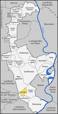
| Location of the local community Hanhofen in the Rhein-Pfalz-Kreis | ||
  |
||


Hanhofen is a municipality in the Rhein-Pfalz-Kreis in Rhineland-Palatinate . It belongs to the Römerberg-Dudenhofen community .
geography
location
Hanhofen lies within the Vorderpfalz . The northeast of the district protrudes into the Speyer forest . Hanhofen includes the residential areas Eichenhof, Im Schnepfenstoss, Peterhof, Waldhäuser and Kreuzhof. Neighboring communities are - clockwise - Böhl-Iggelheim , Dudenhofen , Harthausen , Neustadt an der Weinstrasse and Haßloch .
Waters
The Speyerbach flows through the municipality . From the right this first takes on the Kropsbach ; a short time later the Woogbach branches off to the left . Both the Speyerbach and the Woogbach flow in a west-east direction through the development. The Altwiesenbach also flows through the southern municipality .
history
Hanhofen was probably founded by the Franks in the seventh or eighth century , but it was first mentioned in 1156 as "Heinhoven". The current spelling comes from the 18th century.
Emperor Otto II placed the area of today's municipality under the jurisdiction of the diocese of Speyer , Heinrich IV. 1065 transferred the place to the prince-bishop's bishopric. Until the end of the 18th century Hanhofen remained under the sovereignty of the Speyer bishopric , although the place was probably transferred to the Speyer St. Germansstift in 1235 as a branch of the Harthausen parish with full feudal and tithe rights. The sovereignty of the Speyer bishopric was challenged in the 15th century by the city of Speyer , whose citizens destroyed the episcopal castle Marientraut in Hanhofen in 1417 . However, the diocese was able to consolidate its position, so that the castle was rebuilt and Marientraut was declared an episcopal sub-office in 1475 , i.e. the administrative seat of the Speyer Monastery for the surrounding towns. After its dissolution, Hanhofen fell to the Deidesheim office .
From 1798 to 1814, when the Palatinate was part of the French Republic (until 1804) and then part of the Napoleonic Empire , Hanhofen was incorporated into the canton of Speyer in the Donnersberg department and had its own Mairie . In 1815 it was added to Austria . Just one year later, Hanhofen, like the entire region, moved to the Kingdom of Bavaria and its Rhine district . From 1818 to 1862 the community belonged to the Landkommissariat Speyer ; from this the district office of Speyer emerged.
From 1939 the place was part of the district of Speyer . After the Second World War , Dudenhofen became part of the then newly formed state of Rhineland-Palatinate within the French occupation zone . In the course of the first Rhineland-Palatinate administrative reform , the place moved to the district of Ludwigshafen am Rhein , which has been called Rhein-Pfalz-Kreis since 2004 . 1972 Hsnhofen was incorporated into the newly created Verbandsgemeinde Dudenhofen . The place has been part of the Römerberg-Dudenhofen community since 2014 .
History of Marientraut Castle

Marientraut Castle was at the western end of the village north of the main road. The first construction took place in 1414 by the Speyer bishop Raban von Helmstatt to consolidate the claims of the diocese and to control the water sources of Speyer. With reference to an imperial privilege, this castle was destroyed by Speyer citizens in 1417, but the Roman-German King Sigismund confirmed the position of the bishop, so that the castle could be rebuilt from 1422 onwards. From 1464 to 1471, the castle was largely rebuilt by Bishop Matthias von Ramung with four times the area and protected with a tower-filled wall and a moat. After the destruction in the Réunion War , Bishop Damian Hugo Philipp von Schönborn had a baroque palace built on the site of the main castle in 1722 . During the French occupation from 1792 to 1794, the castle was finally completely burned down. The subsequent owner of the property had the ruins removed. In the middle of the 20th century fish ponds were created in the trenches of the outer bailey. The foundations and enclosing walls of a courtyard building on the opposite side of the street have been preserved from the baroque palace.
population
religion
In 2013, 47.2 percent of the population were Catholic and 22.5 percent Protestant. The rest belonged to another religion or were non-denominational.
Population development
The first number of inhabitants is only known for the year 1787, at that time 322 people lived in Hanhofen. In 1815 the place had a total of 460 inhabitants. According to the first cadastral plan from 1820, an increase in the meantime to 500 to 600 people can be estimated. The extent of the buildings remained largely unchanged until 1925, so little changed in terms of population. In 1921 636 inhabitants were counted, in 1926 there were around 700. The town expanded from 1925 to the Second World War in an east and south direction. In the 1960s, the Schillerstraße in the south of the village was built, from the 1970s new housing estates were built in the east. This started a population increase from about 1100 inhabitants in 1960 to 1599 in 1984. In 2010, 2494 people lived in Hanhofen.
politics
Municipal council
The municipal council in Hanhofen has consisted of 20 council members since 2019 (previously there were 16), who were elected in a personalized proportional representation in the local elections on May 26, 2019 , and the honorary local mayor as chairman.
The distribution of seats in the municipal council:
| choice | SPD | CDU | FDP | WGR | total |
|---|---|---|---|---|---|
| 2019 | 11 | 7th | 2 | - | 20 seats |
| 2014 | 9 | 6th | 1 | - | 16 seats |
| 2009 | 8th | 6th | 2 | - | 16 seats |
| 2004 | 6th | 7th | 1 | 2 | 16 seats |
mayor
Friederike Ebli (SPD) was local mayor of Hanhofen from 1994 to 2019. She was replaced by her party colleague Silke Schmitt-Makdice in the 2019 local elections.
Parish partnership
Hanhofen has maintained partnership relationships with Kondoros in Hungary since 1998 .
coat of arms
|
|
Blazon : "In blue a silver marking, in the form of a cross, the arm of which ends in a lying crescent moon."
It was approved by the Bavarian king in 1845 and goes back to a court seal from 1784. |
Culture
Cultural monuments

There are a total of 14 objects on site that are listed , including the St. Martin Church .
nature
In 2006 a peacock fly was sighted on site.
Economy and Infrastructure
traffic
The federal highway 39 runs through the community in a west-east direction , which runs as a bypass directly to the north of the development. From this, the district road 26 branches off to Harthausen and Römerberg. The bus line 507 operated by PalatinaBus runs through the village and creates a connection to Neustadt and Speyer.
Institutions
The community belongs to the judicial district of the Speyer District Court .
tourism
The Palatia cycle path , which leads from Lambrecht to Speyer, runs through the north of the municipality, as well as a hiking path marked with a white and red bar , which connects to Kaiserslautern and Neustadt an der Weinstrasse and Speyer . In addition, the community is on the north route of the Palatinate Way of St. James .
Personalities
- Johann Christoph Hund von Saulheim († 1624); from 1581 chief bishop and governor at Marientraut Castle
- Janina Fautz (* 1995), actress, grew up in Hanhofen
literature
- Dr. Martin Armgart, et al .: 850 years Hanhofen 1156-2006. Forays through local history . Local community Hanhofen 2006, ISBN 3-00-017775-2
- to Hanhofen Castle and Marientraut: Alexander Thon: Hanhofen . In: Jürgen Keddigkeit, Alexander Thon, Rolf Übel (eds.): Palatinate Burgenlexikon. Vol. 2. F – H (= contributions to the history of the Palatinate ). tape 12.2 , 2002, ISBN 3-927754-48-X , ISSN 0936-7640 , p. 274-279 .
Web links
- Hanhofen community
- Literature about Hanhofen in the Rhineland-Palatinate state bibliography
Individual evidence
- ↑ State Statistical Office of Rhineland-Palatinate - population status 2019, districts, communities, association communities ( help on this ).
- ↑ State Statistical Office Rhineland-Palatinate (ed.): Official directory of the municipalities and parts of the municipality. Status: January 2019 [ Version 2020 is available. ] . S. 165 (PDF; 3 MB).
- ↑ KommWis, as of June 30, 2013
- ^ The Regional Returning Officer Rhineland-Palatinate: Local elections 2019, city and municipal council elections
- ↑ The regional returning officer RLP: direct elections 2019. see Römerberg-Dudenhofen, Verbandsgemeinde, second line of results. Retrieved October 9, 2019 .

Altrip | Beindersheim | Birch heather | Bobenheim-Roxheim | Böhl-Iggelheim | Dannstadt-Schauernheim | Dudenhofen | Fußgönheim | Großniedesheim | Hanhofen | Harthausen | Heßheim | Heuchelheim near Frankenthal | Hochdorf-Assenheim | Kleinniedesheim | Lambsheim | Limburgerhof | Maxdorf | Mother city | Neuhofen | Otterstadt | Rödersheim-Gronau | Römerberg | Schifferstadt | Forest lake