
Speyer Monastery
|
Territory in the Holy Roman Empire |
|
|---|---|
| Speyer Monastery | |
| coat of arms | |

|
|
| Alternative names | Principality of Speyer |
| Arose from | Königsgut in Speyergau |
| Form of rule | Electoral principality / corporate state |
| Ruler / government |
Prince-bishop , administrator or vacant : cathedral chapter
|
| Parliament | 1 virile vote on the ecclesiastical bench in the Reichsfürstenrat |
| Reichskreis | Upper Rhine |
| Capitals / residences | Speyer , later Udenheim ( Philippsburg ), finally Bruchsal |
| Denomination / Religions | Roman Catholic , Jewish minority |
| Language / n |
German , Latin
|
| Incorporated into |
France and Margraviate of Baden 1802 (de facto) and 1803 (official)
|
The Hochstift Speyer was a territory in the Holy Roman Empire and until its final secularization in 1803 was the secular domain of the Prince-Bishop of Speyer . The territory of the bishopric included areas in what is now the federal states of Rhineland-Palatinate and Baden-Württemberg . Other areas in Lower Alsace had already come under French sovereignty in the 17th and 18th centuries.
geography
The Hochstift Speyer belonged to the Upper Rhine Empire and covered with a total area of 28 square miles (about 1540 km²) areas on both sides of the Rhine around Bruchsal with the Landfautei am Bruhrain (on the right bank of the Rhine) and in the Palatinate on the left bank of the Rhine. Around 1800 the Hochstift had about 55,000 inhabitants.
history

A diocese of Speyer possibly existed since the 3rd or 4th century, it was first mentioned in a document in 614. Initially (until 748) it belonged to the Archdiocese of Trier , then to the Archdiocese of Mainz until its dissolution in 1803 .
The history of the Speyer Monastery began in the 7th century at the latest, when the Speyer diocese received Königsgut in Speyergau . In the 10th and 11th centuries, other areas were added, including rights and property in the Lahngau , among others. a. in the county of Solms, through donations from Emperor Otto the Great . Construction of the cathedral began in 1030 and was consecrated in 1061. In 1086 Emperor Heinrich IV awarded the remaining parts of the county of Speyergau to the bishopric. The seat of the bishops was the Bischofspfalz Speyer .
From 1111 onwards, the city's citizens increasingly broke away from the rule of the bishop. A mayor was first mentioned in 1230 . In 1294 Speyer received the status of a free imperial city . In 1371 the bishop moved his residence to Udenheim , which was expanded into the Philippsburg fortress at the beginning of the 17th century by Bishop Philipp Christoph von Sötern . The prince-bishops resided there from 1371 to 1723, then in Bruchsal in a newly built castle .
Through French reunions from 1681, which were recognized in the Peace of Rijswijk in 1697 , the first parts of the areas on the left bank of the Rhine came under French sovereignty. The parts of the bishopric on the left bank of the Rhine were ceded to France by the Peace of Lunéville in 1801/02 after previous conquest by French revolutionary troops , while those on the right bank of the Rhine fell to the margraviate of Baden due to the secularization of the ecclesiastical principalities laid down in the Reichsdeputationshauptschluss of 1803 .
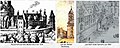
Bishopric Speyer before 1689

Udenheim- Philippsburg with the castle of the bishops of Speyer, 1590

Bishop's residence at Bruchsal Castle

Today's bishop's residence: former vicariate court


.jpg)
Domain
Over the centuries, the rulership of the Speyer Monastery comprised a large number of castles, fortresses, palaces and residences as well as associated offices and localities. Around 1765, according to Büsching's New Description of the Earth and Frey's Description of the Rhine District, the Hochstift included :

Map of the Diocese of Speyer (around 1500)

Drawing of Marientraut Castle, made by Landgrave Moritz von Hessen-Kassel , 1630

Principality of Speyer (by Homann Heirs, 1735)

Speyer Monastery 1793/94


Right bank of the Rhine
- Vizedom- or Oberamt Bruchsal with the residential town of Bruchsal and the Altenbürg hunting lodge in today's Karlsdorf , further five villages: Büchenau , Büchig , Neibsheim , Neuenbürg and Neuthard
- Oberamt Kislau with Kislau Castle , Langenbrücken , Mingolsheim , Ubstadt and eleven other villages: Forst , Hambrücken , Kirrlach , St. Leon , Östringen , Rettigheim , Rot , Stettfeld , Weiher , Kronau and Zeutern
- Office Grombach with the town of Obergrombach with an episcopal castle and the village of Untergrombach
- Amt Rotenberg with the town of Rotenberg with a ruined bishop's castle , Malsch , Rauenberg with an episcopal castle, further five villages: Balzfeld , Dielheim , Horrenberg , Malschenberg and Mühlhausen
- Philippsburg office with the city of Philippsburg , Huttenheim , Neudorf , Oberhausen , Rheinhausen , Rheinsheim , Wiesental and the Waghäusel winery as well as the Eremitage pleasure and hunting palace there , as well as Alt- and Neulußheim and the cathedral chapter of the village of Ketsch
- Waibstadt city school wholesaler
- Together with Baden : Office and city of Gernsbach with Schänen and Staufenberg
- Illingen near Rastatt, which the Vogt zu Gernsbach helped manage
- The cathedral chapter office Jöhlingen with Jöhlingen , Bauerbach , Wöschbach , Ober- and Unterwesingen and Dürrenbüchig
- Together with the Hochstift Worms : Office Neckarsteinach, whereby Neckarsteinach and Darsberg were common and Brombach only Speyer
- Reign of Neuhausen: Consisting of the villages of Neuhausen auf den Fildern and Pfauhausen am Neckar (the reign of Neuhausen had been Hohenbergian since 1269 and Habsburg since the 14th century , it was not until 1769 that it became Prince-Bishop-Speyer)
Left of the Rhine
- Oberamt Kirrweiler with the town of Kirrweiler and Marienburg Castle with Alsterweiler , Diedesfeld , Freimersheim , Geinsheim , Grevenhausen , Großfischlingen , Hambach , Maikammer , St. Martin , Venningen and Weyher
- Office Edesheim with the market town of Edesheim , Hainfeld and Roschbach
- Office Deidesheim with the city of Deidesheim and the Deidesheim Castle with forest , Hochdorf , Königsbach , Lindenberg , Niederkirchen and Ruppertsberg , further the cathedral chapter village Rödersheim
- Office Marientraut with Hanhofen and Marientraut Castle , with Berghausen , Dudenhofen , Harthausen , Heiligenstein , Schifferstadt and Waldsee , further the village Otterstadt , which belonged to the St. Guido monastery in Speyer, further the Ganerbe
Left of the Rhine under French sovereignty
- Fürstete Propstei Weißenburg with accessories
- Oberamt Lauterburg with the city of Lauterburg , Rheinzabern and Jockgrim with a castle, as well as 17 other villages
- Amt Madenburg with Madenburg , Arzheim and four other villages, which were destroyed by the French army in the Palatinate War of Succession
- Amt Dahn with seven villages
literature
- Anton Friedrich Büsching : New description of the earth, third part . 5th edition. tape 3 . Hamburg 1771, p. 1147–1153 ( full text in Google Book Search).
- Michael Frey : Attempt of a geographical-historical-statistical description of the royal Bavarian Rhine district . Second part. Speyer 1836, p. 154–158 ( full text in Google Book Search).
- Franz Xaver Remling : History of the bishops of Speyer . tape 1 . Mainz 1852, p. 151–164 ( full text in Google Book Search).
Individual evidence
- ^ Anton Friedrich Büsching : New description of the earth, third part . 1771, p. 1147–1153 ( full text in Google Book Search).
- ^ Michael Frey : Attempt of a geographical-historical-statistical description of the royal Bavarian Rhine district . 1836, p. 154–158 (( full text in Google Book Search)).
- ↑ Franz Xaver Glasschröder : Diocesan map of the Speyer diocese (around 1500, with subdivision into archdeaconates and land chapters ) . 1906.
Bank of the ecclesiastical princes: Hochstift Worms | Hochstift Speyer | Strasbourg Monastery | Principality of Basel | Hochstift Fulda | Principality of Heitersheim | Fürstpropstei Weißenburg | Prüm Abbey | Former members: Archbishopric Besançon | Hochstift Sitten | Lausanne Bishopric | Bishopric Geneva | Metz Monastery | Toul Monastery | Verdun Monastery
Bank of the secular princes: Principality of Palatinate-Lautern | Principality of Palatinate-Simmern | Principality of Pfalz-Veldenz | Principality of Pfalz-Zweibrücken | Landgraviate of Hessen-Darmstadt | Landgraviate of Hessen-Kassel | Duchy of Savoy | Principality of Hersfeld | Margraviate Nomeny | princely county of Sponheim | princely county of Waldeck | Princely county of Salm ( Wild- und Rheingrafen ) | Princely county of Salm - Kyrburg ( Wild and Rheingrafen ) | Princely county of Nassau-Usingen | Princely county of Nassau - Saarbrücken | Princely county of Nassau-Weilburg | Princely county of Solms - Braunfels | Princely county of Isenburg-Birstein | Former members: Duchy of Lorraine | Duchy of Savoy
Rhenish prelates: Odenheim monastery and knight monastery | Former members: Kaufungen Abbey
Bank of Counts and Lords: County Hanau-Munzenberg | County of Solms - Hohensolms | County of Solms - Lich | County of Solms - Laubach | County of Solms-Rödelheim | County of Koenigstein | County of Isenburg-Büdingen-Büdingen | County of Isenburg-Büdingen-Meerholz | County of Isenburg-Büdingen-Wächtersbach | County of Salm - Grumbach ( Wild and Rheingrafen ) | County of Salm - Stein - Grehweiler ( Wild- und Rheingrafen ) | County of Leiningen - Hardenburg | County of Leiningen - Westerburg | County of Sayn-Wittgenstein -Wittgenstein | County of Sayn-Wittgenstein -Berleburg | County of Kriechingen | County of Hanau-Lichtenberg | County of Salm-Dhaun ( Wild- und Rheingrafen ) | County of Falkenstein | Reipoltskirchen rule | County of Wartenberg | Lordship of Bretzenheim | Dominion Dagstuhl | Lordship of Olbrück | Mensfelden Castle and Village
Bank of the Cities (Imperial Cities): Frankfurt am Main | Friedberg | Wetzlar | Speyer | Worms | Former members: Strasbourg (Strasbourg) | Colmar | Oberehnheim (Obernai) | Kaysersberg | Türkheim (Turckheim) | Rosheim | Benfeld | Schlettstadt (Sélestat) | Hagenau (Haguenau) | Weißenburg (Wissembourg) | Münster in the Gregoriental | Landau in the Palatinate