
Rheinsheim
|
Rheinsheim
City of Philippsburg
|
|
|---|---|
 |
|
| Height : | 98 m |
| Residents : | 2784 (Dec. 31, 2013) |
| Incorporation : | 1st October 1974 |
| Postal code : | 76661 |
| Area code : | 07256 |
Rheinsheim is a district of Philippsburg in the Karlsruhe district in Baden-Württemberg .
The district, which was incorporated on October 1, 1974, has around 3,000 inhabitants today. Rheinsheim borders directly on the city of Germersheim in Rhineland-Palatinate , Huttenheim (Philippsburg) and the city of Philippsburg.
history


Finds in the area around today's Rheinsheim show that the area was already settled in the Neolithic and Bronze Ages. In addition, two Roman house altars and Franconian row graves with grave goods were found, which shows that the conveniently located place on the Rhine must have been important from an early date. In 783 Rheinsheim was mentioned as Reginesheim on the occasion of a donation to the Lorsch Monastery in a document from the Lorsch Codex .
The development of Rheinsheim has been closely linked to Udenheim / Philippsburg since the 12th century . At the beginning they were given privileges due to the proximity to the prince-bishop's residence in Udenheim, but the population had to experience a lot of suffering and misery during the time of the fortress. A normal development of the community was almost impossible due to the nearly two centuries of wars, sieges and repression. The situation only got better when Philippsburg passed to Baden and the bishopric was dissolved. In later years Rheinsheim was repeatedly hit by devastating flood disasters, which flooded the entire village. But the water has always been the livelihood of the Rheinsheimers, which was even immortalized in the coat of arms in the form of an anchor and fish. The Rhine ferry has also played an important role over the centuries. It was mentioned in a document as early as 1191 and it existed until 1960. This is exactly where the 1st French Army crossed the Rhine on March 31, 1945. During the Second World War , many buildings were destroyed, which were then rebuilt with great effort. The incorporation into the city of Philippsburg took place on October 1, 1974.
Crucifixion group

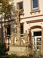
Historical building

Half-timbered house

Half-timbered house Germersheimer Strasse 2


Half-timbered house Hauptstrasse 13
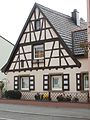
Half-timbered house Hauptstrasse 21

Wayside cross in Huttenheimer Strasse


traffic

Rheinsheim is connected to the national rail network by the Bruhrainbahn ( Bruchsal - Germersheim ). The plan is to extend the Hardtbahn from Karlsruhe via Hochstetten via Rheinsheim to Philippsburg. Rheinsheim is connected to long-distance road traffic through the B 35 ( Illingen –Germersheim). Furthermore, Speyer can be reached very quickly, as the B35 joins the two-lane B9 towards Speyer directly after the Rhine bridge near Germersheim.
Local council
The local council election on May 26, 2019 brought the following result:
| Political party | Percentage / seats |
|---|---|
| CDU : | 32.92% - 3 seats |
| SPD : | 54.43% - 4 seats |
| Free voters : | 12.65% - 1 seats |
Individual evidence
- ↑ Minst, Karl Josef [transl.]: Lorscher Codex (Volume 3), Certificate 1880, July 1, 784 - Reg. 1926. In: Heidelberger historical stocks - digital. Heidelberg University Library, p. 332 , accessed on January 30, 2018 .
- ^ Federal Statistical Office (ed.): Historical municipality directory for the Federal Republic of Germany. Name, border and key number changes in municipalities, counties and administrative districts from May 27, 1970 to December 31, 1982 . W. Kohlhammer, Stuttgart / Mainz 1983, ISBN 3-17-003263-1 , p. 482 .
- ↑ Results of the local council election Rheinsheim 2019. Accessed on July 23, 2019 .
literature
- Dieter Haas: Families and clans in Rheinsheim 1692-1910 . Philippsburg: City of Philippsburg 2009 (= Badische Ortssippenbücher 135)