Staufenberg (Gernsbach)
|
Staufenberg
City of Gernsbach
|
|
|---|---|
| Coordinates: 48 ° 45 ′ 58 ″ N , 8 ° 18 ′ 28 ″ E | |
| Height : | 226 m |
| Area : | 4.01 km² |
| Residents : | 1519 |
| Population density : | 379 inhabitants / km² |
| Incorporation : | 1st January 1971 |
| Postal code : | 76593 |
| Area code : | 07224 |
|
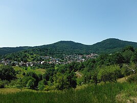
Staufenberg in front of the mountains Kleiner Staufenberg and Merkur (right)
|
|
Staufenberg is a district of Gernsbach in the Rastatt district in Baden-Württemberg .
Geographical location
The Black Forest town is located west of Gernsbach in the Hahnbach valley , below the mountains Merkur ( 669 m ) , formerly called Großer Staufenberg , and Kleiner Staufenberg ( 623 m ) . The place is nestled between two valley flanks covered with meadows, forests and grapevines . With its settlement area as a street village with annexed new building areas, Staufenberg accompanies the district road 3766 towards Baden-Baden over two kilometers .
history
Staufenberg was first mentioned in writing in 1274 as vinea Stoufenberg . It originally consisted of two separate settlements, the upper village and the lower or lower village. As a former Speyrian fiefdom of the Counts of Eberstein , Staufenberg remained Protestant even after the Ebersteiners died out, making it one of the few Protestant islands in the Baden part of the Murg Valley . Agriculture and animal husbandry were the main sources of income for the Staufenberg population. Viticulture has played an important role since the beginning. After this became unprofitable in the 19th century due to the great competition, the Staufenbergers operated the first commercial strawberry cultivation in Germany from around 1840 and well into the 20th century .
On January 1, 1971, Staufenberg was incorporated into the city of Gernsbach .
education
Staufenberg has a municipal kindergarten for children between the ages of three and six. The local elementary school has existed since 1955. It is the support school for reading, writing and arithmetic weaknesses in grades 1 and 2.
Local public transport
The bus line 244 Baden-Baden - Bad Herrenalb of the Karlsruher Verkehrsverbund (KVV) connects Staufenberg every half hour during the week and every hour at the weekend with Gernsbach, where there is a S-Bahn connection to Karlsruhe and Freudenstadt .
coat of arms
The Staufenberg coat of arms carries a red teapot in silver over two diagonally crossed green laurel branches , handle on the left.
Web links
Individual evidence
- ^ Landesarchivdirektion Baden-Württemberg, Landkreis Rastatt and Landesmedienzentrum Baden-Württemberg (ed.): District descriptions of the state of Baden-Württemberg - The district of Rastatt . Jan Thorbecke Verlag, Stuttgart 2002. Volume 2, ISBN 3-7995-1364-7 , p. 125 f.
- ↑ first commercial strawberry cultivation in Germany ; Baden kitchen customer on www.bad-bad.de
- ^ Federal Statistical Office (ed.): Historical municipality directory for the Federal Republic of Germany. Name, border and key number changes in municipalities, counties and administrative districts from May 27, 1970 to December 31, 1982 . W. Kohlhammer, Stuttgart / Mainz 1983, ISBN 3-17-003263-1 , p. 501 .
- ↑ Staufenberg primary school. In: gernsbach.de. City of Gernsbach, accessed on November 15, 2017 .


